More like 'Frank Battersby'
Narrow Results By
Subject
- Advertising Medium - Signs and Signboards 1
- Agricultural Tools and Equipment - Gardening Equipment 3
- Agriculture - Farms 3
- Animals - Deer 2
- Animals - Dogs 2
- Animals - Fowl 2
- Animals - Horses 1
- Animals - Oxen 1
- Armament 1
- Buildings - Agricultural - Greenhouses 1
- Buildings - Commercial 5
- Buildings - Commercial - Hotels and Motels 1
![Kitty Hill holding a doll, [1902] thumbnail](/media/hpo/_Data/_Archives_Images/_Unrestricted/477/477-848.jpg?width=280)
Kitty Hill holding a doll
https://search.heritageburnaby.ca/link/archivedescription39529
- Repository
- City of Burnaby Archives
- Date
- [1902]
- Collection/Fonds
- Peers Family and Hill Family fonds
- Description Level
- Item
- Physical Description
- 1 photograph : b&w ; 5 x 5.2 cm on page 21.5 x 28 cm (pasted in album)
- Scope and Content
- Photograph of Kitty Hill standing in a field holding a doll. The photograph was most likely taken on her father Claude Hill's farm in the Burnaby Lake area. A road (possibly the Pole Line Road, later renamed Sperling Avenue), can be seen in the background.
- Repository
- City of Burnaby Archives
- Date
- [1902]
- Collection/Fonds
- Peers Family and Hill Family fonds
- Physical Description
- 1 photograph : b&w ; 5 x 5.2 cm on page 21.5 x 28 cm (pasted in album)
- Description Level
- Item
- Record No.
- 477-848
- Access Restriction
- No restrictions
- Reproduction Restriction
- No known restrictions
- Accession Number
- 2007-12
- Scope and Content
- Photograph of Kitty Hill standing in a field holding a doll. The photograph was most likely taken on her father Claude Hill's farm in the Burnaby Lake area. A road (possibly the Pole Line Road, later renamed Sperling Avenue), can be seen in the background.
- Subjects
- Geographic Features - Fields
- Toys - Dolls
- Media Type
- Photograph
- Notes
- Title based on contents of photograph
- Geographic Access
- Deer Lake Avenue
- Historic Neighbourhood
- Burnaby Lake (Historic Neighbourhood)
- Planning Study Area
- Morley-Buckingham Area
Images
![Kitty Hill holding a doll, [1902] thumbnail](/media/hpo/_Data/_Archives_Images/_Unrestricted/477/477-848.jpg)
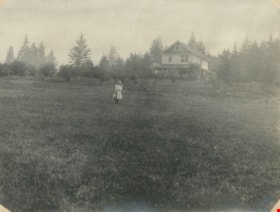
Kitty in front of Broadview
https://search.heritageburnaby.ca/link/archivedescription39556
- Repository
- City of Burnaby Archives
- Date
- 1910
- Collection/Fonds
- Peers Family and Hill Family fonds
- Description Level
- Item
- Physical Description
- 1 photograph : b&w ; 7.6 x 10.2 cm on page 21.5 x 28 cm (pasted in album)
- Scope and Content
- Photograph of Kitty Hill standing in the field in front of her family home, known as Broadview on Buckingham Avenue. This was the second Hill family home in the Burnaby Lake area and it was built around 1907. The first Hill home, Brookfield was on Deer Lake Avenue.
- Repository
- City of Burnaby Archives
- Date
- 1910
- Collection/Fonds
- Peers Family and Hill Family fonds
- Physical Description
- 1 photograph : b&w ; 7.6 x 10.2 cm on page 21.5 x 28 cm (pasted in album)
- Description Level
- Item
- Record No.
- 477-875
- Access Restriction
- No restrictions
- Reproduction Restriction
- No known restrictions
- Accession Number
- 2007-12
- Scope and Content
- Photograph of Kitty Hill standing in the field in front of her family home, known as Broadview on Buckingham Avenue. This was the second Hill family home in the Burnaby Lake area and it was built around 1907. The first Hill home, Brookfield was on Deer Lake Avenue.
- Media Type
- Photograph
- Notes
- Title based on contents of photograph
- Geographic Access
- Buckingham Avenue
- Street Address
- 5730 Buckingham Avenue
- Historic Neighbourhood
- Burnaby Lake (Historic Neighbourhood)
- Planning Study Area
- Morley-Buckingham Area
Images
![O.G. Naud house, [1908] (date of original), copied 1986 thumbnail](/media/hpo/_Data/_Archives_Images/_Unrestricted/126/172-002-003.jpg?width=280)
O.G. Naud house
https://search.heritageburnaby.ca/link/archivedescription39832
- Repository
- City of Burnaby Archives
- Date
- [1908] (date of original), copied 1986
- Collection/Fonds
- Burnaby Historical Society fonds
- Description Level
- Item
- Physical Description
- 1 photograph : b&w ; 8.8 x 12.5 cm print
- Scope and Content
- Photograph is the right side of a three-part panorama (photos 172-002a to 172-002c) showing the land beside the house of Onezime G. Naud at 4737 Victory Road (later renamed Victory Street). A number of adults and children are seen standing in a field.
- Repository
- City of Burnaby Archives
- Date
- [1908] (date of original), copied 1986
- Collection/Fonds
- Burnaby Historical Society fonds
- Subseries
- O.G. Naud subseries
- Physical Description
- 1 photograph : b&w ; 8.8 x 12.5 cm print
- Description Level
- Item
- Record No.
- 172-002-3
- Access Restriction
- No restrictions
- Reproduction Restriction
- No known restrictions
- Accession Number
- BHS1986-21
- Scope and Content
- Photograph is the right side of a three-part panorama (photos 172-002a to 172-002c) showing the land beside the house of Onezime G. Naud at 4737 Victory Road (later renamed Victory Street). A number of adults and children are seen standing in a field.
- Media Type
- Photograph
- Notes
- Title based on contents of photograph
- b&w ; 5.5 x 24.5 cm photocopy of entire panorama accompanying in accession file
- Geographic Access
- Victory Street
- Street Address
- 4737 Victory Street
- Historic Neighbourhood
- Alta-Vista (Historic Neighbourhood)
- Planning Study Area
- Sussex-Nelson Area
Images
![O.G. Naud house, [1908] (date of original), copied 1986 thumbnail](/media/hpo/_Data/_Archives_Images/_Unrestricted/126/172-002-003.jpg)
![Rushing water and forest, [191-] thumbnail](/media/hpo/_Data/_BVM_Images/2022/2022_0032_0099_001.jpg?width=280)
Rushing water and forest
https://search.heritageburnaby.ca/link/museumdescription19677
- Repository
- Burnaby Village Museum
- Date
- [191-]
- Collection/Fonds
- Esther Love Stanley fonds
- Description Level
- Item
- Physical Description
- 1 photograph : b&w ; 11 x 8.5 cm
- Scope and Content
- Photograph view of rushing water and forest.
- Repository
- Burnaby Village Museum
- Collection/Fonds
- Esther Love Stanley fonds
- Description Level
- Item
- Physical Description
- 1 photograph : b&w ; 11 x 8.5 cm
- Scope and Content
- Photograph view of rushing water and forest.
- Accession Code
- BV022.32.99
- Access Restriction
- No restrictions
- Reproduction Restriction
- No known restrictions
- Date
- [191-]
- Media Type
- Photograph
- Scan Resolution
- 600
- Scan Date
- 2023-04-04
- Notes
- Title based on contents of photograph
- Photograph is part of Esther Love Stanley photograph album 1 (BV022.32.1)
Images
![Rushing water and forest, [191-] thumbnail](/media/hpo/_Data/_BVM_Images/2022/2022_0032_0099_001.jpg)
![Diving platform and floating dock on Pitt Lake, [191-] thumbnail](/media/hpo/_Data/_BVM_Images/2022/2022_0032_0073_001.jpg?width=280)
Diving platform and floating dock on Pitt Lake
https://search.heritageburnaby.ca/link/museumdescription19651
- Repository
- Burnaby Village Museum
- Date
- [191-]
- Collection/Fonds
- Esther Love Stanley fonds
- Description Level
- Item
- Physical Description
- 1 photograph : b&w ; 7 x 10.5 cm
- Scope and Content
- Photograph of wooden diving platform and floating dock on Pitt Lake. Mountains are visible in the background.
- Repository
- Burnaby Village Museum
- Collection/Fonds
- Esther Love Stanley fonds
- Description Level
- Item
- Physical Description
- 1 photograph : b&w ; 7 x 10.5 cm
- Scope and Content
- Photograph of wooden diving platform and floating dock on Pitt Lake. Mountains are visible in the background.
- Accession Code
- BV022.32.73
- Access Restriction
- No restrictions
- Reproduction Restriction
- No known restrictions
- Date
- [191-]
- Media Type
- Photograph
- Scan Resolution
- 600
- Scan Date
- 2023-04-04
- Notes
- Title based on contents of photograph
- Photograph is part of Esther Love Stanley photograph album 1 (BV022.32.1)
Images
![Diving platform and floating dock on Pitt Lake, [191-] thumbnail](/media/hpo/_Data/_BVM_Images/2022/2022_0032_0073_001.jpg)
![Douglas Road, Burnaby, [1908] thumbnail](/media/hpo/_Data/_Archives_Images/_Unrestricted/371/449-009.jpg?width=280)
Douglas Road, Burnaby
https://search.heritageburnaby.ca/link/archivedescription38514
- Repository
- City of Burnaby Archives
- Date
- [1908]
- Collection/Fonds
- Burnaby Historical Society fonds
- Description Level
- Item
- Physical Description
- 1 photograph : sepia postcard ; 8.8 x 14 cm
- Scope and Content
- Photographic postcard taken looking northwest along Douglas Road (now Canada Way) near Stanley Street. Two unidentified people are standing next to a wooden fence running alongside the road (above Lubbock's Creek) and a number of houses (including the Sprott house) are visible in the background. To…
- Repository
- City of Burnaby Archives
- Date
- [1908]
- Collection/Fonds
- Burnaby Historical Society fonds
- Subseries
- Photographs subseries
- Physical Description
- 1 photograph : sepia postcard ; 8.8 x 14 cm
- Description Level
- Item
- Record No.
- 449-009
- Access Restriction
- No restrictions
- Reproduction Restriction
- No known restrictions
- Accession Number
- BHS2007-04
- Scope and Content
- Photographic postcard taken looking northwest along Douglas Road (now Canada Way) near Stanley Street. Two unidentified people are standing next to a wooden fence running alongside the road (above Lubbock's Creek) and a number of houses (including the Sprott house) are visible in the background. To the right is Burnaby Lake. Stamped at the top of the postcard is "Douglas Road, Burnaby / New Westminster BC."
- Subjects
- Geographic Features - Lakes and Ponds
- Documentary Artifacts - Postcards
- Geographic Features - Roads
- Media Type
- Photograph
- Geographic Access
- Douglas Road
- Stanley Street
- Canada Way
- Deer Lake
- Historic Neighbourhood
- Burnaby Lake (Historic Neighbourhood)
- Planning Study Area
- Lakeview-Mayfield Area
Images
![Douglas Road, Burnaby, [1908] thumbnail](/media/hpo/_Data/_Archives_Images/_Unrestricted/371/449-009.jpg)
![Edith Clayton Outside Burnaby Lake Store, [1913] thumbnail](/media/hpo/_Data/_Archives_Images/_Unrestricted/477/477-201.jpg?width=280)
Edith Clayton Outside Burnaby Lake Store
https://search.heritageburnaby.ca/link/archivedescription38882
- Repository
- City of Burnaby Archives
- Date
- [1913]
- Collection/Fonds
- Peers Family and Hill Family fonds
- Description Level
- Item
- Physical Description
- 1 photograph : sepia ; 8.2 x 12.5 cm on page 14 x 17.5 cm (pasted in album)
- Scope and Content
- Photograph of Edith Clayton standing on the boarded sidewalk outside the Burnaby Lake Store. The photograph was taken looking along Douglas Road (later, Canada Way), towards New Westminster. Edith is dressed in a winter coat with scarf, mittens and hat.
- Repository
- City of Burnaby Archives
- Date
- [1913]
- Collection/Fonds
- Peers Family and Hill Family fonds
- Physical Description
- 1 photograph : sepia ; 8.2 x 12.5 cm on page 14 x 17.5 cm (pasted in album)
- Description Level
- Item
- Record No.
- 477-201
- Access Restriction
- No restrictions
- Reproduction Restriction
- No known restrictions
- Accession Number
- 2007-12
- Scope and Content
- Photograph of Edith Clayton standing on the boarded sidewalk outside the Burnaby Lake Store. The photograph was taken looking along Douglas Road (later, Canada Way), towards New Westminster. Edith is dressed in a winter coat with scarf, mittens and hat.
- Media Type
- Photograph
- Notes
- Title based on caption accompanying photograph
- Geographic Access
- Sperling Avenue
- Douglas Road
- Canada Way
- Historic Neighbourhood
- Burnaby Lake (Historic Neighbourhood)
- Planning Study Area
- Morley-Buckingham Area
Images
![Edith Clayton Outside Burnaby Lake Store, [1913] thumbnail](/media/hpo/_Data/_Archives_Images/_Unrestricted/477/477-201.jpg)
![Fishing at Pitt Lake, [191-] thumbnail](/media/hpo/_Data/_BVM_Images/2022/2022_0032_0078_001.jpg?width=280)
Fishing at Pitt Lake
https://search.heritageburnaby.ca/link/museumdescription19656
- Repository
- Burnaby Village Museum
- Date
- [191-]
- Collection/Fonds
- Esther Love Stanley fonds
- Description Level
- Item
- Physical Description
- 1 photograph : b&w ; 8 x 9 cm
- Scope and Content
- Photograph of two men standing on a log while fishing at Pitt Lake.
- Repository
- Burnaby Village Museum
- Collection/Fonds
- Esther Love Stanley fonds
- Description Level
- Item
- Physical Description
- 1 photograph : b&w ; 8 x 9 cm
- Scope and Content
- Photograph of two men standing on a log while fishing at Pitt Lake.
- Subjects
- Recreational Activities - Fishing
- Geographic Features
- Geographic Features - Natural Waterways
- Accession Code
- BV022.32.78
- Access Restriction
- No restrictions
- Reproduction Restriction
- No known restrictions
- Date
- [191-]
- Media Type
- Photograph
- Scan Resolution
- 600
- Scan Date
- 2023-04-04
- Notes
- Title based on contents of photograph
- Photograph is part of Esther Love Stanley photograph album 1 (BV022.32.1)
Images
![Fishing at Pitt Lake, [191-] thumbnail](/media/hpo/_Data/_BVM_Images/2022/2022_0032_0078_001.jpg)

Government Road
https://search.heritageburnaby.ca/link/archivedescription35567
- Repository
- City of Burnaby Archives
- Date
- 1912 (date of original), copied 1986
- Collection/Fonds
- Burnaby Historical Society fonds
- Description Level
- Item
- Physical Description
- 1 photograph : b&w ; 12.7 x 17.8 cm print
- Scope and Content
- Photograph looking east on Government Road from the Haddon family house. One of the men in the photo is Robert Haddon. The other two people are unidentified. Note the loose gravel roadway and the bridge over Eagle Creek.
- Repository
- City of Burnaby Archives
- Date
- 1912 (date of original), copied 1986
- Collection/Fonds
- Burnaby Historical Society fonds
- Subseries
- Pioneer Tales subseries
- Physical Description
- 1 photograph : b&w ; 12.7 x 17.8 cm print
- Description Level
- Item
- Record No.
- 204-425
- Access Restriction
- No restrictions
- Reproduction Restriction
- No known restrictions
- Accession Number
- BHS1988-03
- Scope and Content
- Photograph looking east on Government Road from the Haddon family house. One of the men in the photo is Robert Haddon. The other two people are unidentified. Note the loose gravel roadway and the bridge over Eagle Creek.
- Names
- Haddon, Robert
- Media Type
- Photograph
- Notes
- Title based on contents of photograph
- Geographic Access
- Eagle Creek
- Government Road
- Historic Neighbourhood
- Lozells (Historic Neighbourhood)
- Planning Study Area
- Government Road Area
Images

![Love family at Pitt Lake, [191-] thumbnail](/media/hpo/_Data/_BVM_Images/2022/2022_0032_0077_001.jpg?width=280)
Love family at Pitt Lake
https://search.heritageburnaby.ca/link/museumdescription19655
- Repository
- Burnaby Village Museum
- Date
- [191-]
- Collection/Fonds
- Esther Love Stanley fonds
- Description Level
- Item
- Physical Description
- 1 photograph : b&w ; 8 x 11 cm
- Scope and Content
- Photograph of members of the Love family at Pitt Lake. Women are identified left to right as; Phoebe Love Feedham, Esther Love Stanley and Martha "Dot" Love Brandrith. The three women are sitting on a large piece of driftwood. One man is standing behind them and two men are paddling a canoe on th…
- Repository
- Burnaby Village Museum
- Collection/Fonds
- Esther Love Stanley fonds
- Description Level
- Item
- Physical Description
- 1 photograph : b&w ; 8 x 11 cm
- Scope and Content
- Photograph of members of the Love family at Pitt Lake. Women are identified left to right as; Phoebe Love Feedham, Esther Love Stanley and Martha "Dot" Love Brandrith. The three women are sitting on a large piece of driftwood. One man is standing behind them and two men are paddling a canoe on the lake behind.
- Subjects
- Geographic Features - Lakes and Ponds
- Transportation - Boats
- Recreational Activities - Canoeing
- Geographic Features
- Names
- Feedham, Phoebe Leonard Love
- Stanley, Esther Love
- Brandrith, Martha Dorothy “Dot” Love
- Love Family
- Accession Code
- BV022.32.77
- Access Restriction
- No restrictions
- Reproduction Restriction
- No known restrictions
- Date
- [191-]
- Media Type
- Photograph
- Scan Resolution
- 600
- Scan Date
- 2023-04-04
- Notes
- Title based on contents of photograph
- Photograph is part of Esther Love Stanley photograph album 1 (BV022.32.1)
- annotation in white ink on album page reads: "ESTHER in dark dress"
Images
![Love family at Pitt Lake, [191-] thumbnail](/media/hpo/_Data/_BVM_Images/2022/2022_0032_0077_001.jpg)
![Love family on rock at White Rock beach, [c. 1910] thumbnail](/media/hpo/_Data/_BVM_Images/2022/2022_0032_0028_001.jpg?width=280)
Love family on rock at White Rock beach
https://search.heritageburnaby.ca/link/museumdescription19311
- Repository
- Burnaby Village Museum
- Date
- [c. 1910]
- Collection/Fonds
- Esther Love Stanley fonds
- Description Level
- Item
- Physical Description
- 1 photograph : b&w ; 8.5 x 11 cm
- Scope and Content
- Photograph of six unidentified members of the Love family seated on top of a giant boulder located on White Rock beach. Members of the family are wearing hats, dress coats and dresses. A wooden plank is visible in the bottom right of the photograph which provided access to the top of the rock.
- Repository
- Burnaby Village Museum
- Collection/Fonds
- Esther Love Stanley fonds
- Description Level
- Item
- Physical Description
- 1 photograph : b&w ; 8.5 x 11 cm
- Material Details
- Photograph is over exposed, washing out some of the detail
- Scope and Content
- Photograph of six unidentified members of the Love family seated on top of a giant boulder located on White Rock beach. Members of the family are wearing hats, dress coats and dresses. A wooden plank is visible in the bottom right of the photograph which provided access to the top of the rock.
- Names
- Love Family
- Accession Code
- BV022.32.28
- Access Restriction
- No restrictions
- Reproduction Restriction
- No known restrictions
- Date
- [c. 1910]
- Media Type
- Photograph
- Scan Resolution
- 600
- Scan Date
- 2023-04-04
- Notes
- Title based on contents of photograph
- Photograph is part of Esther Love Stanley photograph album 1 (BV022.32.1)
Images
![Love family on rock at White Rock beach, [c. 1910] thumbnail](/media/hpo/_Data/_BVM_Images/2022/2022_0032_0028_001.jpg)
![Men riding bicycles, [1914] thumbnail](/media/hpo/_Data/_BVM_Images/1971/197200110015.jpg?width=280)
Men riding bicycles
https://search.heritageburnaby.ca/link/museumdescription3101
- Repository
- Burnaby Village Museum
- Date
- [1914]
- Collection/Fonds
- Burnaby Village Museum Photograph collection
- Description Level
- Item
- Physical Description
- 1 photograph : b&w glass negative ; 16.4 x 21.3 cm
- Scope and Content
- Photograph of a paved road lined with electric poles on both sides and a wood plank sidewalk on one side of the road. There are two men in suits and bowler hats riding bicycles and another man in suit and bowler hat standing on the sidewalk. The sun is casting long shadows from the left side of the…
- Repository
- Burnaby Village Museum
- Collection/Fonds
- Burnaby Village Museum Photograph collection
- Description Level
- Item
- Physical Description
- 1 photograph : b&w glass negative ; 16.4 x 21.3 cm
- Scope and Content
- Photograph of a paved road lined with electric poles on both sides and a wood plank sidewalk on one side of the road. There are two men in suits and bowler hats riding bicycles and another man in suit and bowler hat standing on the sidewalk. The sun is casting long shadows from the left side of the photograph. An earlier catalogue record from 1988 conjectures that the photograph may be of Kingsway in Burnaby, possibly near Gilley looking east towards Griffiths Avenue. The record also dates the negative, ca. 1914.
- Geographic Access
- Kingsway
- Griffiths Avenue
- Accession Code
- HV972.11.15
- Access Restriction
- No restrictions
- Reproduction Restriction
- No known restrictions
- Date
- [1914]
- Media Type
- Photograph
- Historic Neighbourhood
- Edmonds (Historic Neighbourhood)
- Planning Study Area
- Kingsway-Beresford Area
- Scan Resolution
- 300
- Scan Date
- 14/8/2006
- Scale
- 100
- Notes
- Title based on contents of photograph
- 1 b&w contact print accompanying negative
Images
![Men riding bicycles, [1914] thumbnail](/media/hpo/_Data/_BVM_Images/1971/197200110015.jpg)
![Mountainside plank road, [190-] thumbnail](/media/hpo/_Data/_BVM_Images/1977/197900500189.jpg?width=280)
Mountainside plank road
https://search.heritageburnaby.ca/link/museumdescription446
- Repository
- Burnaby Village Museum
- Date
- [190-]
- Collection/Fonds
- Hugh H. Stewart fonds
- Description Level
- Item
- Physical Description
- 1 photograph : sepia ; 15.3 x 11.0 cm mounted on cardboard 24.5 x 17.8 cm
- Scope and Content
- Photograph of an automobile parked on the side of a plank road by a mountain rising steeply to the right of the image. An unidentified man is seen leaning on the fence at the side of the plank road.
- Repository
- Burnaby Village Museum
- Collection/Fonds
- Hugh H. Stewart fonds
- Description Level
- Item
- Physical Description
- 1 photograph : sepia ; 15.3 x 11.0 cm mounted on cardboard 24.5 x 17.8 cm
- Scope and Content
- Photograph of an automobile parked on the side of a plank road by a mountain rising steeply to the right of the image. An unidentified man is seen leaning on the fence at the side of the plank road.
- Accession Code
- HV979.50.189
- Access Restriction
- No restrictions
- Reproduction Restriction
- No known restrictions
- Date
- [190-]
- Media Type
- Photograph
- Scan Resolution
- 600
- Scan Date
- 2023-09-12
- Notes
- Title based on contents of photograph
Images
![Mountainside plank road, [190-] thumbnail](/media/hpo/_Data/_BVM_Images/1977/197900500189.jpg)
![Sunnyside, [between 1915 and 1934] thumbnail](/media/hpo/_Data/_Archives_Images/_Unrestricted/550/550-078.jpg?width=280)
Sunnyside
https://search.heritageburnaby.ca/link/archivedescription82502
- Repository
- City of Burnaby Archives
- Date
- [between 1915 and 1934]
- Collection/Fonds
- Hill family and Vidal family fonds
- Description Level
- Item
- Physical Description
- 1 photograph : sepia ; 7.5 x 10.5 cm
- Scope and Content
- Photograph shows the embankment of a body of water lined with houses and trees in Toronto, Ontario.
- Repository
- City of Burnaby Archives
- Date
- [between 1915 and 1934]
- Collection/Fonds
- Hill family and Vidal family fonds
- Physical Description
- 1 photograph : sepia ; 7.5 x 10.5 cm
- Description Level
- Item
- Record No.
- 550-078
- Access Restriction
- No restrictions
- Reproduction Restriction
- No known restrictions
- Accession Number
- 2013-03
- Scope and Content
- Photograph shows the embankment of a body of water lined with houses and trees in Toronto, Ontario.
- Media Type
- Photograph
- Notes
- Title based on note accompanying photograph
- Note in pencil on album page reads: "Sunnyside"
- Note in pencil on verso reads: "Sunnyside"
Images
![Sunnyside, [between 1915 and 1934] thumbnail](/media/hpo/_Data/_Archives_Images/_Unrestricted/550/550-078.jpg)
![Trail to Shell installation, [1911] thumbnail](/media/hpo/_Data/_Archives_Images/_Unrestricted/204/204-711.jpg?width=280)
Trail to Shell installation
https://search.heritageburnaby.ca/link/archivedescription35852
- Repository
- City of Burnaby Archives
- Date
- [1911]
- Collection/Fonds
- Burnaby Historical Society fonds
- Description Level
- Item
- Physical Description
- 1 photograph : b&w ; 12.7 x 17.8 cm print
- Scope and Content
- Photograph of the trail to the powder magazine wharf at the Shell installation. Fred Holmes and his friends would catch crabs from the wharf, where dynamite was stored at end of the pier in a shack (thus its name).
- Repository
- City of Burnaby Archives
- Date
- [1911]
- Collection/Fonds
- Burnaby Historical Society fonds
- Subseries
- Pioneer Tales subseries
- Physical Description
- 1 photograph : b&w ; 12.7 x 17.8 cm print
- Description Level
- Item
- Record No.
- 204-711
- Access Restriction
- No restrictions
- Reproduction Restriction
- No known restrictions
- Accession Number
- BHS1988-03
- Scope and Content
- Photograph of the trail to the powder magazine wharf at the Shell installation. Fred Holmes and his friends would catch crabs from the wharf, where dynamite was stored at end of the pier in a shack (thus its name).
- Media Type
- Photograph
- Photographer
- Phillips, James William "Jim"
- Notes
- Title based on contents of photograph
- Geographic Access
- Barnet Road
- Street Address
- 7790 Barnet Road
- Planning Study Area
- Westridge Area
Images
![Trail to Shell installation, [1911] thumbnail](/media/hpo/_Data/_Archives_Images/_Unrestricted/204/204-711.jpg)
![Unidentified shoreline, [1905] thumbnail](/media/hpo/_Data/_Archives_Images/_Unrestricted/477/477-116.jpg?width=280)
Unidentified shoreline
https://search.heritageburnaby.ca/link/archivedescription38797
- Repository
- City of Burnaby Archives
- Date
- [1905]
- Collection/Fonds
- Peers Family and Hill Family fonds
- Description Level
- Item
- Physical Description
- 1 photograph : sepia ; 5.5 x 5.5 cm on page 11.5 x 14 cm (pasted in album)
- Scope and Content
- Photograph of a pier in the water next to a rocky outcropping, most likely in the Caulfield area of West Vancouver.
- Repository
- City of Burnaby Archives
- Date
- [1905]
- Collection/Fonds
- Peers Family and Hill Family fonds
- Physical Description
- 1 photograph : sepia ; 5.5 x 5.5 cm on page 11.5 x 14 cm (pasted in album)
- Description Level
- Item
- Record No.
- 477-116
- Access Restriction
- No restrictions
- Reproduction Restriction
- No known restrictions
- Accession Number
- 2007-12
- Scope and Content
- Photograph of a pier in the water next to a rocky outcropping, most likely in the Caulfield area of West Vancouver.
- Media Type
- Photograph
- Notes
- Title based on contents of photograph
Images
![Unidentified shoreline, [1905] thumbnail](/media/hpo/_Data/_Archives_Images/_Unrestricted/477/477-116.jpg)
![Water with mountainous shoreline, [191-] thumbnail](/media/hpo/_Data/_BVM_Images/2022/2022_0032_0117_001.jpg?width=280)
Water with mountainous shoreline
https://search.heritageburnaby.ca/link/museumdescription19695
- Repository
- Burnaby Village Museum
- Date
- [191-]
- Collection/Fonds
- Esther Love Stanley fonds
- Description Level
- Item
- Physical Description
- 1 photograph : b&w ; 8 x 10.5 cm
- Scope and Content
- Photograph of body of water with mountainous shoreline and reflections in water.
- Repository
- Burnaby Village Museum
- Collection/Fonds
- Esther Love Stanley fonds
- Description Level
- Item
- Physical Description
- 1 photograph : b&w ; 8 x 10.5 cm
- Scope and Content
- Photograph of body of water with mountainous shoreline and reflections in water.
- Accession Code
- BV022.32.117
- Access Restriction
- No restrictions
- Reproduction Restriction
- No known restrictions
- Date
- [191-]
- Media Type
- Photograph
- Scan Resolution
- 600
- Scan Date
- 2023-04-04
- Notes
- Title based on contents of photograph
- Photograph is part of Esther Love Stanley photograph album 1 (BV022.32.1)
Images
![Water with mountainous shoreline, [191-] thumbnail](/media/hpo/_Data/_BVM_Images/2022/2022_0032_0117_001.jpg)
![Women and children on top of rock, [c. 1910] thumbnail](/media/hpo/_Data/_BVM_Images/2022/2022_0032_0033_001.jpg?width=280)
Women and children on top of rock
https://search.heritageburnaby.ca/link/museumdescription19316
- Repository
- Burnaby Village Museum
- Date
- [c. 1910]
- Collection/Fonds
- Esther Love Stanley fonds
- Description Level
- Item
- Physical Description
- 1 photograph : b&w ; 8 x 10.5 cm
- Scope and Content
- Photograph of two women and three children seated on top of a large rock covered with moss. The rock is located in a clearing of a forested area. Many of trees surrounding the rock are without branches and appear to be damaged by a forest fire.
- Repository
- Burnaby Village Museum
- Collection/Fonds
- Esther Love Stanley fonds
- Description Level
- Item
- Physical Description
- 1 photograph : b&w ; 8 x 10.5 cm
- Material Details
- Photograph is over exposed, washing out some of the detail
- Scope and Content
- Photograph of two women and three children seated on top of a large rock covered with moss. The rock is located in a clearing of a forested area. Many of trees surrounding the rock are without branches and appear to be damaged by a forest fire.
- Accession Code
- BV022.32.33
- Access Restriction
- No restrictions
- Reproduction Restriction
- No known restrictions
- Date
- [c. 1910]
- Media Type
- Photograph
- Scan Resolution
- 600
- Scan Date
- 2023-04-04
- Notes
- Title based on contents of photograph
- Photograph is part of Esther Love Stanley photograph album 1 (BV022.32.1)
Images
![Women and children on top of rock, [c. 1910] thumbnail](/media/hpo/_Data/_BVM_Images/2022/2022_0032_0033_001.jpg)
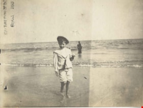
Alexander E. E. "Bill" Vidal
https://search.heritageburnaby.ca/link/archivedescription82417
- Repository
- City of Burnaby Archives
- Date
- [between 1907 and 1913]
- Collection/Fonds
- Hill family and Vidal family fonds
- Description Level
- Item
- Physical Description
- 1 photograph : sepia ; 8 x 11 cm
- Scope and Content
- Photograph shows a boy identified as Alexander E. E. "Bill" Vidal standing on a beach.
- Repository
- City of Burnaby Archives
- Date
- [between 1907 and 1913]
- Collection/Fonds
- Hill family and Vidal family fonds
- Physical Description
- 1 photograph : sepia ; 8 x 11 cm
- Description Level
- Item
- Record No.
- 550-039
- Access Restriction
- No restrictions
- Reproduction Restriction
- No known restrictions
- Accession Number
- 2013-03
- Scope and Content
- Photograph shows a boy identified as Alexander E. E. "Bill" Vidal standing on a beach.
- Subjects
- Geographic Features - Beaches
- Media Type
- Photograph
- Notes
- Title based on caption accompanying photograph and contents of photograph
- Note in pencil on album page photograph reads: "Alexander Vidal"
- Note in black pen on verso reads: "Uncle Bill"
Images

Alfred Bingham's writings - Track 1
https://search.heritageburnaby.ca/link/oralhistory251
- Repository
- City of Burnaby Archives
- Date Range
- 1865-1919
- Length
- 0:10:18
- Summary
- This portion of the recording includes Alfred Bingham's essay entitled Stump Rangers, a listing of early settlers that includes addresses and short descriptions, essays on Confederation Park, land clearing and on Burnaby's first Council meeting.
- Repository
- City of Burnaby Archives
- Summary
- This portion of the recording includes Alfred Bingham's essay entitled Stump Rangers, a listing of early settlers that includes addresses and short descriptions, essays on Confederation Park, land clearing and on Burnaby's first Council meeting.
- Date Range
- 1865-1919
- Photo Info
- Alfred Bingham, April 20, 1947. Item no. 010-066
- Length
- 0:10:18
- Scope and Content
- Recording is of Alfred Bingham's writings, as read by Alfred Bingham. Major themes discussed are: Pioneers, early days in Burnaby and the Co-op Movement. To view "Narrow By" terms for each track expand this description and see "Notes".
- Biographical Notes
- Alfred "Alf" Bingham was born in England in 1892 and moved to Canada in 1912. His first job in Canada was laying track for the Grand Trunk Pacific Railway (GTPR) from Edmonton to McBride in 1912. His second was in Vancouver at the Rat Portage Mill on False Creek, working on the Resaw machine. He quit after one week due to poor working conditions. After taking part in the 1919 Winnipeg General Strike as a delegate of the Retail and Mailorder Union (A.F.L.) on the Winnipeg Trades and Labour Council, Alfred moved to Burnaby where he and fellow Burnaby residents Aungus McLean and Percy Little worked ten hour days to build a Shingle Mill on the edge of Burnaby Lake for Simpson & Giberson. George Green, carpenter and millwright (author of “The History of Burnaby”) also helped in the construction of the mill. Alfred built his own home from lumber cut from the mill in the Lochdale area on Sherlock Street between Curtis Street and Kitchener Street. On April 10, 1920 Alfred married Mary Jane “Ada” Reynolds. Alfred and Ada often took in foster children during their marriage. Due to her nursing experience, Ada was often called upon to deliver babies in the Burnaby area. Alfred and Ada Bingham were instrumental members of the Army of the Common Good, collecting vegetables and grains from growers in the area and even producing over 125 tons of vegetables from its own gardens to feed children and youth suffering from the lack of resources during the Depression years. The army was in operation for ten years and during that time the members organised the Credit Union movement of British Columbia and drew up the Credit Union act thorough the Vancouver Co-operative Council. They also started Co-Op stores and the Co-Op Wholesale Society. Alfred was also Secretary of the Burnaby Housing committee and in 1946 he became the Secretary of the North Burnaby Labour Progressive Party (LPP). Mary Jane “Ada” (Reynolds) Bingham died on August 9, 1969. Her husband Alfred died on April 29, 1979.
- Total Tracks
- 12
- Total Length
- 1:38:06
- Interviewee Name
- Bingham, Alfred "Alf"
- Collection/Fonds
- Burnaby Historical Society fonds
- Subseries
- Oral history subseries
- Transcript Available
- MSS142-001 contains transcripts for each of the short stories
- Media Type
- Sound Recording
- Web Notes
- Interview was digitized in 2010 allowing it to be accessible on Heritage Burnaby. The digitization project was initiated by the Community Heritage Commission with support from City of Burnaby Council and the BC History Digitization Program of the Irving K. Barber Learning Centre, University of British Columbia. It was recognized by the Heritage Society of BC with an award in 2012.
Images

Audio Tracks
Track one of recording of Alfred Bingham's writings
Track one of recording of Alfred Bingham's writings
https://search.heritageburnaby.ca/media/hpo/_Data/_Archives_Oral_Histories/_Unrestricted/100-13-20-2/100-13-20-2_Track_1.mp3