Narrow Results By
Decade
- 2020s 57
- 2010s 122
- 2000s 241
- 1990s 372
- 1980s 299
- 1970s 423
- 1960s 340
- 1950s
- 1940s 384
- 1930s 502
- 1920s 351
- 1910s
- 1900s
- 1890s 34
- 1880s 9
- 1870s 7
- 1860s 7
- 1850s 4
- 1840s 3
- 1830s 2
- 1820s 2
- 1810s 2
- 1800s 2
- 1790s 1
- 1780s 1
- 1770s 1
- 1760s 1
- 1750s 1
- 1740s 1
- 1730s 1
- 1720s 1
- 1710s 1
- 1700s 1
- 1690s 1
- 1680s 1
- 1670s 1
- 1660s 1
- 1650s 1
- 1640s 1
- 1630s 1
- 1620s 1
- 1610s 1
- 1600s 1
Creator
- Aero Surveys Limited 2
- Associated Factory Mutual Fire Insurance Cos 1
- Barrowclough, George Alfred 3
- Bergson, George 2
- Binks, James 3
- British Columbia Underwriters' Association 2
- Broadbridge Commercial Photo Company 1
- Brown, W. 1
- Bullen & Lamb 1
- Burnaby Village Museum 22
- Burnett & McGugan, Engineers and Surveyors 2
- Campbell Studios Limited 1
![Aerial view of Vancouver, North Vancouver and West Vancouver, [195-] (date of orignal), copied 1985 thumbnail](/media/hpo/_Data/_BVM_Images/1985/1985_0457_0008_001.jpg?width=280)
Aerial view of Vancouver, North Vancouver and West Vancouver
https://search.heritageburnaby.ca/link/museumdescription10589
- Repository
- Burnaby Village Museum
- Date
- [195-] (date of orignal), copied 1985
- Collection/Fonds
- Burnaby Village Museum Photograph collection
- Description Level
- Item
- Physical Description
- 1 photograph : b&w copy negative ; 10 x 12.5 cm
- Scope and Content
- Aerial photograph looking west towards Vancouver, North Vancouver and West Vancouver.
- Repository
- Burnaby Village Museum
- Collection/Fonds
- Burnaby Village Museum Photograph collection
- Description Level
- Item
- Physical Description
- 1 photograph : b&w copy negative ; 10 x 12.5 cm
- Scope and Content
- Aerial photograph looking west towards Vancouver, North Vancouver and West Vancouver.
- Accession Code
- BV985.457.8
- Access Restriction
- No restrictions
- Reproduction Restriction
- May be restricted by third party rights
- Date
- [195-] (date of orignal), copied 1985
- Media Type
- Photograph
- Scan Resolution
- 1200
- Scan Date
- 2022-06-07
- Photographer
- Aero Surveys Limited
- Notes
- Title based on contents of photograph
Images
![Aerial view of Vancouver, North Vancouver and West Vancouver, [195-] (date of orignal), copied 1985 thumbnail](/media/hpo/_Data/_BVM_Images/1985/1985_0457_0008_001.jpg)
![Sectional map and street directory of Vancouver : Dial map of greater Vancouver including adjacent municipalities, [ca. 1950] thumbnail](/media/hpo/_Data/_BVM_Cartographic_Material/2000/2000_0003_0011_001%20WEB.jpg?width=280)
Sectional map and street directory of Vancouver : Dial map of greater Vancouver including adjacent municipalities
https://search.heritageburnaby.ca/link/museumdescription8697
- Repository
- Burnaby Village Museum
- Date
- [ca. 1950]
- Collection/Fonds
- Burnaby Village Museum Map collection
- Description Level
- Item
- Physical Description
- 2 maps and 1 p. of textual records on 1 sheet : lithographic prints, col. ; 55.5 x 75 cm + 2 dials and 25 x 72 cm + directory on sheet 55.5 x 75 cm, folded to 28.5 x 12.5 cm
- Scope and Content
- Item is a sectional map and street directory titled "Dial Map of Greater Vancouver and adjacent Municipalities" with a map on one side titled "Dial Map of Greater Vancouver and Suburbs" including Vancouver, West Vancouver, North Vancouver and Burnaby and includes street car and bus lines, railways,…
- Repository
- Burnaby Village Museum
- Collection/Fonds
- Burnaby Village Museum Map collection
- Description Level
- Item
- Physical Description
- 2 maps and 1 p. of textual records on 1 sheet : lithographic prints, col. ; 55.5 x 75 cm + 2 dials and 25 x 72 cm + directory on sheet 55.5 x 75 cm, folded to 28.5 x 12.5 cm
- Material Details
- Scales 1:42240, 1:144823
- 2 alphabetic dials on narrow strips of paper attached to map by grommets
- Scope and Content
- Item is a sectional map and street directory titled "Dial Map of Greater Vancouver and adjacent Municipalities" with a map on one side titled "Dial Map of Greater Vancouver and Suburbs" including Vancouver, West Vancouver, North Vancouver and Burnaby and includes street car and bus lines, railways, hospitals, parks, block nos. and street indexes with two alphabetic dials, one for Vancouver, the other for New Westminster. The other side of the map includes a map of "Fraser Valley" along with a directory of Vancouver street car and bus routes, business blocks, public buildings, hospitals, bathing beaches, locations of Vancouver fire halls and Vancouver city schools.
- Creator
- Dominion Map and Blueprint Co.
- Publisher
- Sectional Map and Street Directory Company
- Geographic Access
- Vancouver
- Accession Code
- BV000.3.11
- Access Restriction
- No restrictions
- Reproduction Restriction
- No known restrictions
- Date
- [ca. 1950]
- Media Type
- Cartographic Material
- Scan Resolution
- 380
- Scan Date
- 22-Dec-2020
- Scale
- 100
- Notes
- Title based on contents of map
Images
![Sectional map and street directory of Vancouver : Dial map of greater Vancouver including adjacent municipalities, [ca. 1950] thumbnail](/media/hpo/_Data/_BVM_Cartographic_Material/2000/2000_0003_0011_001%20WEB.jpg)


![Blue Haven Motel, [195-] thumbnail](/media/hpo/_Data/_Archives_Images/_Unrestricted/126/199-001.jpg?width=280)
Blue Haven Motel
https://search.heritageburnaby.ca/link/archivedescription35136
- Repository
- City of Burnaby Archives
- Date
- [195-]
- Collection/Fonds
- Burnaby Historical Society fonds
- Description Level
- Item
- Physical Description
- 1 photograph : col. postcard ; 8.9 x 13.9 cm
- Scope and Content
- Photographic postcard of the Blue Haven Motel, 7026 Kingsway. The description printed on the back of the postcard reads, "Blue Haven Motel / 7026 Kingsway, South Burnaby, B.C., Canada / Mrgs.: Mr. and Mrs. A. Pearson / 22 Units - 4 Stars - AAA - ACRA / T.V. Equipped / Telephone LA 1-9942." The bui…
- Repository
- City of Burnaby Archives
- Date
- [195-]
- Collection/Fonds
- Burnaby Historical Society fonds
- Subseries
- Photographs subseries
- Physical Description
- 1 photograph : col. postcard ; 8.9 x 13.9 cm
- Description Level
- Item
- Record No.
- 199-001
- Access Restriction
- No restrictions
- Reproduction Restriction
- Reproduce for fair dealing purposes only
- Accession Number
- BHS1987-10
- Scope and Content
- Photographic postcard of the Blue Haven Motel, 7026 Kingsway. The description printed on the back of the postcard reads, "Blue Haven Motel / 7026 Kingsway, South Burnaby, B.C., Canada / Mrgs.: Mr. and Mrs. A. Pearson / 22 Units - 4 Stars - AAA - ACRA / T.V. Equipped / Telephone LA 1-9942." The building on the left side of the photograph has "Office" written on the door. Cars and motel units are seen at the right.
- Names
- Blue Haven Motel
- Media Type
- Photograph
- Responsibility
- Printed on back of postcard: "Traveltime product. Made in Vancouver, Canada, by Grant-Mann Lithographers, Ltd."
- Notes
- Title based on contents of photograph
- Geographic Access
- Kingsway
- Street Address
- 7026 Kingsway
- Historic Neighbourhood
- Edmonds (Historic Neighbourhood)
- Planning Study Area
- Stride Avenue Area
Images
![Blue Haven Motel, [195-] thumbnail](/media/hpo/_Data/_Archives_Images/_Unrestricted/126/199-001.jpg)

Indexed guide map of the city of Vancouver and Suburbs
https://search.heritageburnaby.ca/link/museumdescription8694
- Repository
- Burnaby Village Museum
- Date
- 1914
- Collection/Fonds
- Burnaby Village Museum Map collection
- Description Level
- Item
- Physical Description
- 1 map + textual record : col. lithographic print on paper ; 55 x 78 cm on sheet 58.5 x 82 cm folded to 20 x 10 cm
- Scope and Content
- Item consists of a map "Indexed Guide Map of the City of Vancouver and Suburbs compiled and published by The Vancouver Map and Blueprint Co. Ltd. Map shows district lots, blocks and boundaries between City of Vancouver, Point Grey, South Vancouver, Burnaby, New Westminster and parts of Richmond, No…
- Repository
- Burnaby Village Museum
- Collection/Fonds
- Burnaby Village Museum Map collection
- Description Level
- Item
- Physical Description
- 1 map + textual record : col. lithographic print on paper ; 55 x 78 cm on sheet 58.5 x 82 cm folded to 20 x 10 cm
- Material Details
- Scale not defined
- Map is folded into booklet form
- Scope and Content
- Item consists of a map "Indexed Guide Map of the City of Vancouver and Suburbs compiled and published by The Vancouver Map and Blueprint Co. Ltd. Map shows district lots, blocks and boundaries between City of Vancouver, Point Grey, South Vancouver, Burnaby, New Westminster and parts of Richmond, North Vancouver and West Vancouver. Concentric cirlces indicate the distance in miles from the intersection of Main Street and Hastings Street, Vancouver in intervals of 1/2 mile. Map is folded into booklet form and includes a four page index with cardstock cover. Index page 1 is titled "Hotels"; page 2 is titled "District Lot Index"; pages 3-8 "Street Index".
- Publisher
- Vancouver Map and Blueprint Company Limited
- Edition
- 5th Edition revised to June 1914
- Geographic Access
- Vancouver
- Accession Code
- HV983.9.18
- Date
- 1914
- Media Type
- Cartographic Material
- Scan Resolution
- 600
- Scan Date
- 2023-08-17
- Notes
- Transcribed title from map and cover
- Sticker adhered to front cover of index of two lions "Service / "WE GIVE IT" / WESTERN SPECIALTY / LIMITED/ STATIONERS AND PRINTERS / VANCOUVER - B.C."
Documents
Zoomable Images

![Bandsand in Stanley Park, Vancouver, BC, [between 1908 and 1911] thumbnail](/media/hpo/_Data/_BVM_Images/1972/1972_0050_0010_001.jpg?width=280)
Bandsand in Stanley Park, Vancouver, BC
https://search.heritageburnaby.ca/link/museumdescription1071
- Repository
- Burnaby Village Museum
- Date
- [between 1908 and 1911]
- Collection/Fonds
- Burnaby Village Museum Photograph collection
- Description Level
- Item
- Physical Description
- 1 photograph : sepia ; 7.3 x 9.9 cm
- Scope and Content
- Photograph of people walking towards the bandstand in Stanley Park, Vancouver. In 1934, the Malkin Bowl was erected at the site where the banstand used to be. An annotation on the back of the photograph reads, "Band stand in Stanley Park where Malkin Bowl now stands."
- Repository
- Burnaby Village Museum
- Collection/Fonds
- Burnaby Village Museum Photograph collection
- Description Level
- Item
- Physical Description
- 1 photograph : sepia ; 7.3 x 9.9 cm
- Scope and Content
- Photograph of people walking towards the bandstand in Stanley Park, Vancouver. In 1934, the Malkin Bowl was erected at the site where the banstand used to be. An annotation on the back of the photograph reads, "Band stand in Stanley Park where Malkin Bowl now stands."
- Geographic Access
- Vancouver
- Accession Code
- HV972.50.10
- Access Restriction
- No restrictions
- Reproduction Restriction
- No known restrictions
- Date
- [between 1908 and 1911]
- Media Type
- Photograph
- Scan Resolution
- 600
- Scan Date
- 2023-04-04
- Photographer
- Dean, H.M.
- Notes
- Title based on contents of photograph
Images
![Bandsand in Stanley Park, Vancouver, BC, [between 1908 and 1911] thumbnail](/media/hpo/_Data/_BVM_Images/1972/1972_0050_0010_001.jpg)
BC Electric Guide to Greater Vancouver
https://search.heritageburnaby.ca/link/archivedescription65826
- Repository
- City of Burnaby Archives
- Date
- April 1952
- Collection/Fonds
- Burnaby Historical Society fonds
- Description Level
- Item
- Physical Description
- 1 map : col. ; on paper ; 54 x 85 cm folded to 21 x 9 cm
- Scope and Content
- Item is the BC Electric Guide to Greater Vancouver consisting of a transit system map of Greater Vancouver, a Greater Vancouver Street Index along with listings for Parks, Golf and Country Clubs, etc.
- Repository
- City of Burnaby Archives
- Date
- April 1952
- Collection/Fonds
- Burnaby Historical Society fonds
- Subseries
- Pixie McGeachie subseries
- Physical Description
- 1 map : col. ; on paper ; 54 x 85 cm folded to 21 x 9 cm
- Material Details
- Scale : one inch equals approximately 0.57 miles
- Description Level
- Item
- Record No.
- 42686
- Accession Number
- BHS1996-08
- Scope and Content
- Item is the BC Electric Guide to Greater Vancouver consisting of a transit system map of Greater Vancouver, a Greater Vancouver Street Index along with listings for Parks, Golf and Country Clubs, etc.
- Media Type
- Cartographic Material
![BCER work train at the cross over at Commercial Dr. and 6th Ave. in Vancouver, [1953] (date of original), copied [ca. 2000] thumbnail](/media/hpo/_Data/_BVM_Images/2012/2012_0018_0006_001.jpg?width=280)
BCER work train at the cross over at Commercial Dr. and 6th Ave. in Vancouver
https://search.heritageburnaby.ca/link/museumdescription2882
- Repository
- Burnaby Village Museum
- Date
- [1953] (date of original), copied [ca. 2000]
- Collection/Fonds
- Burnaby Village Museum Photograph collection
- Description Level
- Item
- Physical Description
- 1 photograph : b&w copy print ; 9 x 13.5 cm
- Scope and Content
- Photograph of British Columbia Electric Railway (BCER) work train at the cross over at Commercial Dr. and 6th Ave. in Vancouver.
- Repository
- Burnaby Village Museum
- Collection/Fonds
- Burnaby Village Museum Photograph collection
- Description Level
- Item
- Physical Description
- 1 photograph : b&w copy print ; 9 x 13.5 cm
- Scope and Content
- Photograph of British Columbia Electric Railway (BCER) work train at the cross over at Commercial Dr. and 6th Ave. in Vancouver.
- Subjects
- Transportation - Electric Railroads
- Geographic Access
- Vancouver
- Accession Code
- BV012.18.6
- Access Restriction
- No restrictions
- Reproduction Restriction
- May be restricted by third party rights
- Date
- [1953] (date of original), copied [ca. 2000]
- Media Type
- Photograph
- Scan Resolution
- 600
- Scan Date
- 13-Mar-2018
- Notes
- Title based on contents of photograph
- Typewritten note on verso of photograph reads: "With the end of BCER Burnaby Lake passenger / service in October of 1953, we see BCER Line Car L4, Flat Car BCER 8041 and crew preparing /for the removal of the cross over at 6th and Commercial in Vancouver."
Images
![BCER work train at the cross over at Commercial Dr. and 6th Ave. in Vancouver, [1953] (date of original), copied [ca. 2000] thumbnail](/media/hpo/_Data/_BVM_Images/2012/2012_0018_0006_001.jpg)
![Bird's eye view of New Westminster, Burnaby and Vancouver, [ca. 1911] thumbnail](/media/hpo/_Data/_BVM_Cartographic_Material/1983/1983_0012_0001_002%20Web.jpg?width=280)
Bird's eye view of New Westminster, Burnaby and Vancouver
https://search.heritageburnaby.ca/link/museumdescription8199
- Repository
- Burnaby Village Museum
- Date
- [ca. 1911]
- Collection/Fonds
- Burnaby Village Museum Map collection
- Description Level
- Item
- Physical Description
- 1 map : hand painted ; 65.5 x 99 cm
- Scope and Content
- An untitled monochromatic grayscale map of a developer's bird's eye view looking north west from Burnaby Mountain. View includes Burnaby, New Westminster, Vancouver with the North shore in the distance. Burnaby neighbourhood subdivisions of "Burnaby Heights" and "Buena Vista" are featured near the…
- Repository
- Burnaby Village Museum
- Collection/Fonds
- Burnaby Village Museum Map collection
- Description Level
- Item
- Physical Description
- 1 map : hand painted ; 65.5 x 99 cm
- Scope and Content
- An untitled monochromatic grayscale map of a developer's bird's eye view looking north west from Burnaby Mountain. View includes Burnaby, New Westminster, Vancouver with the North shore in the distance. Burnaby neighbourhood subdivisions of "Burnaby Heights" and "Buena Vista" are featured near the centre of the map. These neighbourhood subdivisions were marketed by Real Estate Agents Liebly & Blumer in 1911. Roads, buildings, factories, railways and bridges are identified on the map.
- Subjects
- Businesses - Real Estate Agencies
- Responsibility
- Leibly & Blumer Realty Co. Incorporated
- Accession Code
- HV983.12.1
- Access Restriction
- No restrictions
- Reproduction Restriction
- No known restrictions
- Date
- [ca. 1911]
- Media Type
- Cartographic Material
- Historic Neighbourhood
- East Burnaby (Historic Neighbourhood)
- Vancouver Heights (Historic Neighbourhood)
- Planning Study Area
- Cariboo-Armstrong Area
- Burnaby Heights Area
- Scan Resolution
- 300
- Scan Date
- December 2020
- Scale
- 100
- Notes
- Title based on contents of map
- Note in pencil on verso of photograph reads: "Make tint block of Buena Vista / Blocks only as shown in lots"
Zoomable Images
![Bird's eye view of New Westminster, Burnaby and Vancouver, [ca. 1911] thumbnail](/media/hpo/_Data/_BVM_Cartographic_Material/1983/1983_0012_0001_001_seadragon/1983_0012_0001_001.jpg?w=280)
British Columbia Railway Company Limited and Vancouver Power Company Limited Franchises, Agreements and Bylaws 1908
https://search.heritageburnaby.ca/link/archivedescription14358
- Repository
- City of Burnaby Archives
- Date
- 1908
- Collection/Fonds
- City Council and Office of the City Clerk fonds
- Description Level
- Item
- Physical Description
- Textual record
- Repository
- City of Burnaby Archives
- Date
- 1908
- Collection/Fonds
- City Council and Office of the City Clerk fonds
- Physical Description
- Textual record
- Description Level
- Item
- Record No.
- 17346
- Accession Number
- 2005-12
- Media Type
- Textual Record
- Notes
- Item is a published book.
The City of Vancouver B.C.
https://search.heritageburnaby.ca/link/archivedescription66103
- Repository
- City of Burnaby Archives
- Date
- [between 1916 and 1929]
- Collection/Fonds
- Burnaby Historical Society fonds
- Description Level
- Item
- Physical Description
- 1 map : b&w ink on paper ; 56 x 107 cm folded to 21 x 12.5 cm
- Scope and Content
- Item is a map of "[the] City of Vancouver B.C" drawn prior to amalgamation of Point Grey and South Vancouver with the City of Vancouver.
- Repository
- City of Burnaby Archives
- Date
- [between 1916 and 1929]
- Collection/Fonds
- Burnaby Historical Society fonds
- Subseries
- Ephemera subseries
- Physical Description
- 1 map : b&w ink on paper ; 56 x 107 cm folded to 21 x 12.5 cm
- Material Details
- Map has a blue construction paper cover
- Scale : 1 inch = 1000 feet
- Description Level
- Item
- Record No.
- 42707
- Accession Number
- BHS2007-04
- Scope and Content
- Item is a map of "[the] City of Vancouver B.C" drawn prior to amalgamation of Point Grey and South Vancouver with the City of Vancouver.
- Media Type
- Cartographic Material
- Notes
- Transcribed title
Deed of Land between George A. Stevens and George Leonard re District Lot 352 South Vancouver
https://search.heritageburnaby.ca/link/museumdescription18783
- Repository
- Burnaby Village Museum
- Date
- 28 Mar. 1908
- Collection/Fonds
- Love family fonds
- Description Level
- Item
- Physical Description
- 1 p. of textual records
- Scope and Content
- Item consists of Deed of Land between George A. Stevens and George Leonard for South Vancouver Lots eleven (11) and twelve (12) of the Subdivision of Lots nine (9), ten (10), eleven (11), twelve (12) and thirteen (13) of Block sixteen (16) in District Lot 352.
- Repository
- Burnaby Village Museum
- Collection/Fonds
- Love family fonds
- Description Level
- Item
- Physical Description
- 1 p. of textual records
- Scope and Content
- Item consists of Deed of Land between George A. Stevens and George Leonard for South Vancouver Lots eleven (11) and twelve (12) of the Subdivision of Lots nine (9), ten (10), eleven (11), twelve (12) and thirteen (13) of Block sixteen (16) in District Lot 352.
- Accession Code
- BV992.26.3
- Access Restriction
- No restrictions
- Reproduction Restriction
- No known restrictions
- Date
- 28 Mar. 1908
- Media Type
- Textual Record
- Notes
- Title based on contents of item
- buff paper, legal-sized, with black print; pink borders; folds out.
- Front of folded cover reads: "Dated March 28th 1908 / George A. Stevens / TO / George Leonard / DEED OF LAND / SITUATE I / South Vancouver / AND BEING / Lots Eleven (11) & Twelve (12) SubDiv (9)(10)(11)(12)&(13) Bk. (16) & Lot (352)" "115.5 x 33 / EVANS & HASTINGS PRINTERS"
- Inside reads: "This Indenture.../ between George A. Stevens of the City of Vancouver.../ And / George Leonard.../ ...sum of eight hundred and fifty ($850) .../ ... Lots Eleven (11) & Twelve (12) of the Subdivision of Lots nine (9) Ten (10) Eleven (11) Twelve (12) and Thirteen (13) / of Block Sixteen (16) in DistLot-Three Hundred & / fifty two (352) Group one (1) New Westminster District..."
- signed by George Stevens twice, small red seals; witnessed twice by William Carter; "FOR MAKER" signed by William Carter, April 4, 1908; stamp seal "WILLIAM CARTER" "BRITISH COLUMBIA" "NOTARY PUBLIC"
Dial map of Greater Vancouver and Suburbs
https://search.heritageburnaby.ca/link/archivedescription65840
- Repository
- City of Burnaby Archives
- Date
- 1958
- Collection/Fonds
- Burnaby Historical Society fonds
- Description Level
- Item
- Physical Description
- 1 map : col. ; ink on sheet 55 x 73 cm folded to 28 x 14 cm
- Scope and Content
- Item is a Dial map of Greater Vancouver and Suburbs, published by Dominion Map and Blueprint Ltd. in Vancouver. Map includes both old and new street names.
- Repository
- City of Burnaby Archives
- Date
- 1958
- Collection/Fonds
- Burnaby Historical Society fonds
- Subseries
- Municipal record subseries
- Physical Description
- 1 map : col. ; ink on sheet 55 x 73 cm folded to 28 x 14 cm
- Material Details
- Scale : 1 1/4 inches = 1 mile
- Description Level
- Item
- Record No.
- 42695
- Access Restriction
- Open access
- Accession Number
- BHS1999-05
- Scope and Content
- Item is a Dial map of Greater Vancouver and Suburbs, published by Dominion Map and Blueprint Ltd. in Vancouver. Map includes both old and new street names.
- Media Type
- Cartographic Material
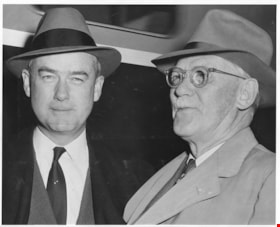
Edgar G. Burton and Charles Luther Burton arriving in Vancouver
https://search.heritageburnaby.ca/link/museumdescription17259
- Repository
- Burnaby Village Museum
- Date
- May 1954
- Collection/Fonds
- Simpsons-Sears Limited Burnaby fonds
- Description Level
- Item
- Physical Description
- 1 photograph : b&w ; 20.5 x 25.5 cm
- Scope and Content
- Photograph of (left to right) Edgar G. Burton, President of Simpsons-Sears Ltd. and Charles Luther Burton (Chairman of the Board, Simpsons-Sears) arriving on a Great Northern train in Vancouver.
- Repository
- Burnaby Village Museum
- Collection/Fonds
- Simpsons-Sears Limited Burnaby fonds
- Description Level
- Item
- Physical Description
- 1 photograph : b&w ; 20.5 x 25.5 cm
- Scope and Content
- Photograph of (left to right) Edgar G. Burton, President of Simpsons-Sears Ltd. and Charles Luther Burton (Chairman of the Board, Simpsons-Sears) arriving on a Great Northern train in Vancouver.
- Subjects
- Transportation - Rail
- Geographic Access
- Vancouver
- Accession Code
- BV021.26.9
- Access Restriction
- No restrictions
- Reproduction Restriction
- May be restricted by third party rights
- Date
- May 1954
- Media Type
- Photograph
- Scan Resolution
- 600
- Scan Date
- 2021-09-21
- Notes
- Title based on contents of photograph
- Photograph was removed from original scrapbook with newspaper clippings, photographs and ephemera
Images
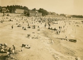
English Bay, Vancouver
https://search.heritageburnaby.ca/link/museumdescription1072
- Repository
- Burnaby Village Museum
- Date
- 1911
- Collection/Fonds
- Burnaby Village Museum Photograph collection
- Description Level
- Item
- Physical Description
- 1 photograph : b&w ; 7.3 x 9.9 cm
- Scope and Content
- Photograph of the beach at English Bay, Vancouver. The beach is crowded an buildings can be seen in the background.
- Repository
- Burnaby Village Museum
- Collection/Fonds
- Burnaby Village Museum Photograph collection
- Description Level
- Item
- Physical Description
- 1 photograph : b&w ; 7.3 x 9.9 cm
- Scope and Content
- Photograph of the beach at English Bay, Vancouver. The beach is crowded an buildings can be seen in the background.
- Geographic Access
- Vancouver
- Accession Code
- HV972.50.11
- Access Restriction
- No restrictions
- Reproduction Restriction
- No known restrictions
- Date
- 1911
- Media Type
- Photograph
- Scan Resolution
- 600
- Scan Date
- 2023-04-04
- Photographer
- Dean, H.M.
- Notes
- Title based on contents of photograph
- Annotation on verso of photograph reads: "English Bay/ 1911."
Images


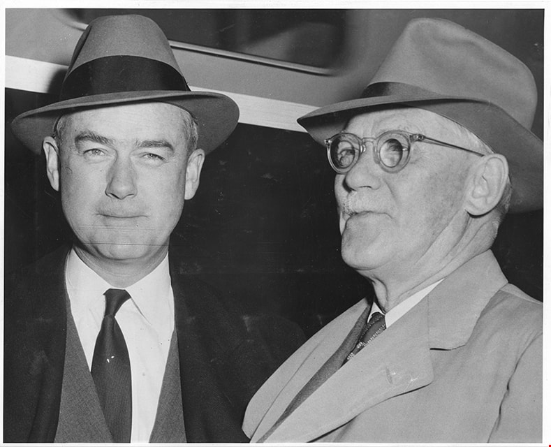
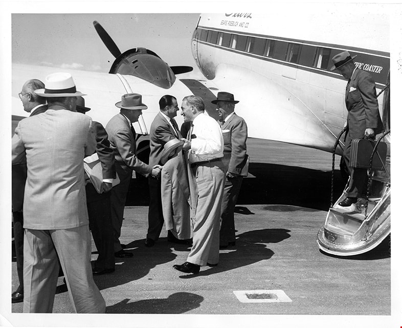
Executive and managers arriving at Vancouver Airport
https://search.heritageburnaby.ca/link/museumdescription17345
- Repository
- Burnaby Village Museum
- Date
- 12 Jul. 1954
- Collection/Fonds
- Simpsons-Sears Limited Burnaby fonds
- Description Level
- Item
- Physical Description
- 1 photograph : b&w ; 20.5 x 25.5 cm
- Scope and Content
- Photograph of unidentified exectuive and managers arriving on the Sears-Roebuck "Pacific Coaster" at Vancouver Airport July 12, 1954.
- Repository
- Burnaby Village Museum
- Collection/Fonds
- Simpsons-Sears Limited Burnaby fonds
- Description Level
- Item
- Physical Description
- 1 photograph : b&w ; 20.5 x 25.5 cm
- Scope and Content
- Photograph of unidentified exectuive and managers arriving on the Sears-Roebuck "Pacific Coaster" at Vancouver Airport July 12, 1954.
- Subjects
- Transportation - Air
- Names
- Simpsons-Sears Limited
- Geographic Access
- Vancouver
- Accession Code
- BV021.26.96
- Access Restriction
- No restrictions
- Reproduction Restriction
- May be restricted by third party rights
- Date
- 12 Jul. 1954
- Media Type
- Photograph
- Photographer
- Croton Studio Limited
- Notes
- Title based on contents of photograph
- Photograph was removed from original scrapbook with newspaper clippings, photographs and ephemera
- Stamp on verso of photograph reads: "Croton STUDIO / NEW WESTMINSTER B.C."
- For list of names of executive, managers and flight crew that flew on this aircraft see: BV021.26.95
Images
Fire insurance plans - Greater Vancouver - Volume XVIII - Municipality of Burnaby
https://search.heritageburnaby.ca/link/museumdescription17798
- Repository
- Burnaby Village Museum
- Date
- 1927-1950
- Collection/Fonds
- Burnaby Village Museum Map collection
- Description Level
- Item
- Physical Description
- 22 plans on 12 sheets : col. lithographic print ; 64 x 54 cm
- Scope and Content
- Item consists of fire insurance plans titled "Greater Vancouver / Volume XVIII / Municipality / of Burnaby" surveyed May 1927, revised in October 1940 and September 1950. Includes a two page key plan (G and H) and twenty associated plans numbered; 1801; 1802; 1803; 1804; 1805; 1806; 1807; 1808; 18…
- Repository
- Burnaby Village Museum
- Collection/Fonds
- Burnaby Village Museum Map collection
- Description Level
- Item
- Physical Description
- 22 plans on 12 sheets : col. lithographic print ; 64 x 54 cm
- Material Details
- Scales between [1:600] and [1:6000]
- Scope and Content
- Item consists of fire insurance plans titled "Greater Vancouver / Volume XVIII / Municipality / of Burnaby" surveyed May 1927, revised in October 1940 and September 1950. Includes a two page key plan (G and H) and twenty associated plans numbered; 1801; 1802; 1803; 1804; 1805; 1806; 1807; 1808; 1809; 1810; 1811; 1812; 1813; 1814; 1815; 1819; 1820; 1821; 1822 and 1832.
- Publisher
- Plan Department of Fire Branch of British Columbia Underwriters' Association
- Accession Code
- BV987.1.70
- Access Restriction
- No restrictions
- Reproduction Restriction
- May be restricted by third party rights
- Date
- 1927-1950
- Media Type
- Cartographic Material
- Scan Resolution
- 400
- Scan Date
- 11/17/2021
- Notes
- Title based on contents of item
- Scale 1 inch = 50 feet
- These plans were removed from a bound book with labels on cover page reading: "Plan No. 90 / THIS INSURANCE PLAN / of / Vancouver VOLUME "8" / IN THE PROPERTY OF THE / British Columbia Insurance Underwriter's Association / Vancouver B.C. / AND IS LOANED / MELVILLE F. THOMSON CO. .../ Date May 26th, 1934"; / "Plan No. 74 / THIS INSURANCE PLAN / OF / VANCOUVER VOLUME "9"" / Plan No. 11 / THIS INSURANCE PLAN / OF / BURNABY VOLUMES 15-19" / "THIS PLAN IS THE PROPERTY OF / THE / BRITISH LAW INSURANCE COMPANY / LIMITED"
- Contact Burnaby Village Museum to view associated fire insurance plans
Fire insurance plans - Greater Vancouver - Volume XVII - Municipality of Burnaby
https://search.heritageburnaby.ca/link/museumdescription17797
- Repository
- Burnaby Village Museum
- Date
- 1927-1950
- Collection/Fonds
- Burnaby Village Museum Map collection
- Description Level
- Item
- Physical Description
- 4 plans on 4 sheets : col. lithographic prints
- Scope and Content
- Item consists of fire insurance plans titled "Greater Vancouver / Volume XVII / Municipality / of Burnaby" surveyed May 1927, revised in October 1940 and September 1950. Includes a two page key plan (E and F) and two associated plans numbered 1729 and 1738 (located within District Lot 35).
- Repository
- Burnaby Village Museum
- Collection/Fonds
- Burnaby Village Museum Map collection
- Description Level
- Item
- Physical Description
- 4 plans on 4 sheets : col. lithographic prints
- Scope and Content
- Item consists of fire insurance plans titled "Greater Vancouver / Volume XVII / Municipality / of Burnaby" surveyed May 1927, revised in October 1940 and September 1950. Includes a two page key plan (E and F) and two associated plans numbered 1729 and 1738 (located within District Lot 35).
- Publisher
- Plan Department of Fire Branch of British Columbia Underwriters' Association
- Accession Code
- BV987.1.70
- Access Restriction
- No restrictions
- Reproduction Restriction
- May be restricted by third party rights
- Date
- 1927-1950
- Media Type
- Cartographic Material
- Historic Neighbourhood
- Central Park (Historic Neighbourhood)
- Planning Study Area
- Garden Village Area
- Scan Resolution
- 400
- Scan Date
- 2021-11-17
- Notes
- Title based on contents of item
- These plans were removed from a bound book with labels on cover page reading: "Plan No. 90 / THIS INSURANCE PLAN / of / Vancouver VOLUME "8" / IN THE PROPERTY OF THE / British Columbia Insurance Underwriter's Association / Vancouver B.C. / AND IS LOANED / MELVILLE F. THOMSON CO. .../ Date May 26th, 1934"; / "Plan No. 74 / THIS INSURANCE PLAN / OF / VANCOUVER VOLUME "9"" / Plan No. 11 / THIS INSURANCE PLAN / OF / BURNABY VOLUMES 15-19" / "THIS PLAN IS THE PROPERTY OF / THE / BRITISH LAW INSURANCE COMPANY / LIMITED"
- Contact Burnaby Village Museum to view associated fire insurance plans XVIII
The Founders of Vancouver - Pamphlet
https://search.heritageburnaby.ca/link/archivedescription8855
- Repository
- City of Burnaby Archives
- Date
- 1956
- Collection/Fonds
- Planning Department fonds
- Description Level
- Item
- Physical Description
- Textual record
- Repository
- City of Burnaby Archives
- Date
- 1956
- Collection/Fonds
- Planning Department fonds
- Series
- Planning General series
- Physical Description
- Textual record
- Description Level
- Item
- Record No.
- 11816
- Accession Number
- 2001-02
- Media Type
- Textual Record
General Relief Board - I.O.O.F. of Vancouver
https://search.heritageburnaby.ca/link/museumdescription9762
- Repository
- Burnaby Village Museum
- Date
- [ca. 1915]
- Collection/Fonds
- Hugh H. Stewart fonds
- Description Level
- Item
- Physical Description
- 1 textual record
- Scope and Content
- Item consists of a member card to certify Mr. H.H. Stewart as an accredited member of the General Relief Board, I.O.O.F. of Vancouver, B.C. The card is a visiting permit that allows the bearer to visit the Public or Semi-private Wards of the Vancouver General Hospital at any time. The card is signe…
- Repository
- Burnaby Village Museum
- Collection/Fonds
- Hugh H. Stewart fonds
- Description Level
- Item
- Physical Description
- 1 textual record
- Scope and Content
- Item consists of a member card to certify Mr. H.H. Stewart as an accredited member of the General Relief Board, I.O.O.F. of Vancouver, B.C. The card is a visiting permit that allows the bearer to visit the Public or Semi-private Wards of the Vancouver General Hospital at any time. The card is signed by the V.G.H. superintendent, Malcolm T. MacEachren.
- Names
- Stewart, Hugh Henry
- Accession Code
- HV979.50.271
- Access Restriction
- No restrictions
- Reproduction Restriction
- No known restrictions
- Date
- [ca. 1915]
- Media Type
- Textual Record
- Notes
- Title based on content of Item
![Granville Street, Vancouver, [1911] thumbnail](/media/hpo/_Data/_BVM_Images/1972/1972_0050_0006_001.jpg?width=280)
Granville Street, Vancouver
https://search.heritageburnaby.ca/link/museumdescription1067
- Repository
- Burnaby Village Museum
- Date
- [1911]
- Collection/Fonds
- Burnaby Village Museum Photograph collection
- Description Level
- Item
- Physical Description
- 1 photograph : b&w ; 8.0 x 10.2 cm
- Scope and Content
- Photograph of Granville Street, looking south. The two tall buildings to the sides are under construction. Busy street activities can be seen below with two trams running along the tracks. The old Vancouver Hotel is in view and the old courthouse (later the Vancouver Art Gallery) is in view faint…
- Repository
- Burnaby Village Museum
- Collection/Fonds
- Burnaby Village Museum Photograph collection
- Description Level
- Item
- Physical Description
- 1 photograph : b&w ; 8.0 x 10.2 cm
- Scope and Content
- Photograph of Granville Street, looking south. The two tall buildings to the sides are under construction. Busy street activities can be seen below with two trams running along the tracks. The old Vancouver Hotel is in view and the old courthouse (later the Vancouver Art Gallery) is in view faintly to the right of the photograph. An annoation on the back of the photograph reads, ""Granville St. - with OLD [underlined] / Vancouver Hotel across / from the Birks Building/ 1911/ (Court House in back of Van Hotel)."
- Geographic Access
- Vancouver
- Accession Code
- HV972.50.6
- Access Restriction
- No restrictions
- Reproduction Restriction
- No known restrictions
- Date
- [1911]
- Media Type
- Photograph
- Scan Resolution
- 600
- Scan Date
- 2023-04-04
- Photographer
- Dean, H.M.
- Notes
- Title based on contents of photograph
Images
![Granville Street, Vancouver, [1911] thumbnail](/media/hpo/_Data/_BVM_Images/1972/1972_0050_0006_001.jpg)