Narrow Results By

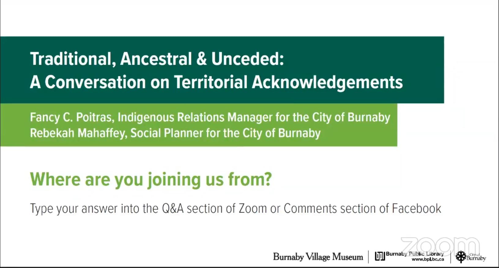
Traditional, Ancestral & Unceded: A Conversation on Territorial Acknowledgements
https://search.heritageburnaby.ca/link/museumdescription15664
- Repository
- Burnaby Village Museum
- Date
- 29 Apr. 2021
- Collection/Fonds
- Burnaby Village Museum fonds
- Description Level
- Item
- Physical Description
- 1 video recording (mp4) (87 min., 17 sec.) : digital, col., sd., stereo ; 29 fps
- Scope and Content
- Item consists of a video recording of a live Zoom webinar hosted by Burnaby Village Museum curator, Jane Lemke. The webinar is titled "Traditional, Ancestral & Unceded: A Conversation on Territorial Acknowledgements" and is presented by Fancy Poitras, Indigenous Relations Manager for the City of Bu…
- Repository
- Burnaby Village Museum
- Collection/Fonds
- Burnaby Village Museum fonds
- Description Level
- Item
- Physical Description
- 1 video recording (mp4) (87 min., 17 sec.) : digital, col., sd., stereo ; 29 fps
- Material Details
- Presenters: Fancy Poitras and Rebekah Mahaffey
- Host: Jane Lemke
- Date of Presentation: Thursday, April 29, 7:00 pm - 8:30 pm
- Total Number of tracks: 1
- Total Length of all tracks: 87 min., 17 sec.
- Recording Device: Zoom video communication platform
- Recording Note: Film was edited from it's original recorded version (95 min., 34 sec.) to edited version (87 min., 17 sec.) for public viewing on Heritage Burnaby. This live recording experienced technical difficulties with the viewer window during the first few minutes of the presentation. This is resolved at 15:36.
- Scope and Content
- Item consists of a video recording of a live Zoom webinar hosted by Burnaby Village Museum curator, Jane Lemke. The webinar is titled "Traditional, Ancestral & Unceded: A Conversation on Territorial Acknowledgements" and is presented by Fancy Poitras, Indigenous Relations Manager for the City of Burnaby and Rebekah Mahaffey, Social Planner for the City of Burnaby. The Zoom webinar is the second in a series of six "Neighbourhood Speaker series" webinars exploring a range of topics shared by Indigenous speakers and knowledge keepers that were presented and made available to the public between April 27 and May 12, 2021. The live webinar was also made available on the Burnaby Village Museum's facebook page. Community members were invited to participate by bringing questions during the interactive online sessions. The webinar opens with host, Jane Lemke providing a Land Acknowlegement "The land on which Burnaby now sits is the ancestral and unceded homelands of the hən̓q̓əmin̓əm and Sḵwx̱wú7mesh speaking peoples". Jane explains that providing a land acknowledgement is part of the City of Burnaby's official policy and that the land is on the shared territory of many Nations including the sq̓əc̓iy̓aɁɬ təməxʷ (Katzie), Kway-quit-lum, Kwantlen, ʷməθkʷəy̓əm (Musqueam), Sḵwx̱wú7mesh, and Tsleil-Waututh Nations. Understanding the definitions of language groups, Nations, shared territory and many of the importance words form a basis of the subject matter for this webinar. Fancy Poitras and Rebekah Mahaffey enter a discussion exploring this topic while posing thought provoking questions to each other. As Burnaby's Indigenous Relations Manager, Fancy Poitras conveys her own experiences and knowledge while providing historical references and recommendations for further educational resources around territorial land acknowledgment. Following their discussion, Fancy and Rebekah take questions from the audience that are moderated by the host, Jane Lemke.
- History
- Fancy Poitras was hired as the City of Burnaby's first Indigenous Relations Manager in 2021. Prior to her role, she worked for the First Nations Health Authority for more than five years, first as a Senior Policy Analyst, then as the Manager and Acting Director of Strategic Policy; throughout her time with FNHA, she worked on an extensive portfolio of health and wellness, and service design and delivery issues, including primary care, cancer, seniors and elders. Fancy has a Master’s degree in Public Policy and a Post-Baccalaureate Diploma in Social Policy Issues from Simon Fraser University, and a Bachelor of Arts in Political Science from University of Alberta. Fancy is a member of Mikisew Cree First Nation, Treaty 8 territory, and she grew up primarily in the Northwest Territories. Rebekah Mahaffey (she, her, hers) is a Social Policy Planner at the City of Burnaby. She is a settler on these lands, and is of mixed French-Scottish-Irish ancestry. She grew up in Indonesia, Libya and England and has called the west coast home for almost 15 years. Rebekah has degrees in International Development, Art History and Urban Planning. In her work she focuses on inter-culturalism, access and inclusion, anti-racism, and working with Burnaby’s 2SLGBTQQIA community. When not at work, she enjoys hiking, reading, and listening to podcasts. She lives in Vancouver with her young child.
- Creator
- Burnaby Village Museum
- Subjects
- Indigenous peoples - British Columbia
- Indigenous peoples - Canada - Government relations
- Indigenous peoples - British Columbia - Languages
- Indigenous peoples - Canada - , Treatment of
- Responsibility
- Lemke, Jane
- Accession Code
- BV021.17.2
- Access Restriction
- No restrictions
- Reproduction Restriction
- No known restrictions
- Date
- 29 Apr. 2021
- Media Type
- Moving Images
- Notes
- Title based on contents of video recording The following links wereshared at the end of the presentation:
- My Conversations with Canadians by Lee Maracle: https://bookhugpress.ca/shop/ebooks/essays-ebooks/conversations-with-canadians-by-lee-maracle/
- 21 Things You May Not Know About the Indian Act by Bob Joseph: https://www.ictinc.ca/books/21-things-you-may-not-know-about-the-indian-act
- CBC documentary series 8th Fire: https://www.cbc.ca/firsthand/blog/8th-fire-wabs-walk-through-history ‘Whose Land’ App: https://apps.apple.com/ca/app/whose-land/id1350310353
- “Unreserved” Podcast, Episode: January 20, 2019, ‘Hayden King’: https://www.cbc.ca/radio/unreserved/redrawing-the-lines-1.4973363/i-regret-it-hayden-king-on-writing-ryerson-university-s-territorial-acknowledgement-1.4973371
- Guidelines for Indigenous Territory Acknowledgement http://www.burnaby.ca/Assets/Burnaby+Interagency/Guidelines+for+Indigenous+Territory+Acknowledgement.pdf
- United Nations Declaration on the Rights of Indigenous Peoples: https://www.un.org/development/desa/indigenouspeoples/declaration-on-the-rights-of-indigenous-peoples.html
- Truth and Reconciliation Commission Calls to Action: http://trc.ca/assets/pdf/Calls_to_Action_English2.pdf
- Missing and Murdered Indigenous Women and Girls Calls for Justice: https://www.mmiwg-ffada.ca/wp-content/uploads/2019/06/Calls_for_Justice.pdf
Images
Video
Traditional, Ancestral & Unceded: A Conversation on Territorial Acknowledgements, 29 Apr. 2021
Traditional, Ancestral & Unceded: A Conversation on Territorial Acknowledgements, 29 Apr. 2021
https://search.heritageburnaby.ca/media/hpo/_Data/_BVM_Moving_Images/2021_0017_0002_002.mp4![Survey and Subdivision plans in New Westminster District Group 1 & Group 2 - Port Moody, Surrey
, [1898-1910] thumbnail](/media/hpo/_Data/_BVM_Cartographic_Material/1977/1977_0093_0073_001.jpg?width=280)
Survey and Subdivision plans in New Westminster District Group 1 & Group 2 - Port Moody, Surrey
https://search.heritageburnaby.ca/link/museumdescription7042
- Repository
- Burnaby Village Museum
- Date
- [1898-1910]
- Collection/Fonds
- Burnaby Village Museum Map collection
- Description Level
- File
- Physical Description
- 10 plans : graphite and ink on paper and linen; various sizes mounted on 2 sides of cardboard 76 x 102 cm
- Scope and Content
- File consists of a large board with four plans in New Westminster District mounted on one side and six plans mounted on the other side. Side A: 1. Plan : black ink and graphite on paper ; 46.5 x 37.5 cm. Title reads: "Bon Accord Hatchery / Sec 6 B5N R1W". Signed by Albert J. Hill P.L.S. August 1…
- Repository
- Burnaby Village Museum
- Collection/Fonds
- Burnaby Village Museum Map collection
- Description Level
- File
- Physical Description
- 10 plans : graphite and ink on paper and linen; various sizes mounted on 2 sides of cardboard 76 x 102 cm
- Material Details
- Scales vary (One chain equals 792 inches)
- Indexed number on tape on edge of board reads "73"
- Scope and Content
- File consists of a large board with four plans in New Westminster District mounted on one side and six plans mounted on the other side. Side A: 1. Plan : black ink and graphite on paper ; 46.5 x 37.5 cm. Title reads: "Bon Accord Hatchery / Sec 6 B5N R1W". Signed by Albert J. Hill P.L.S. August 12, 1903. Plan covers land identified as Section 6, Section 7, Located along the south shore of the Fraser River in Port Mann (Geographic location: Surrey). 2. Plan : black ink and graphite on paper ; 36 x 31 cm. Title reads: "Survey of Portions of Sec. 20 B5N R2W". Plan is stamped in red ink: "Albert J. Hill, Civil Engineer". Scale 4 chains = 1 inch. 3. Plan : black ink on linen ; 14 x 23 cm. Title reads:"Port Moody". Plan covers sections in Lot 191 (District Lot 191) bordered by Burrard Inlet to the west and Lot 235 and Lot 233 to the south. Streets identified include Water Street, Beauregard Street, Yonge Street, Clinton Street and Oxford Street. 4. Plan: graphite and ink on paper ; 43.5 x 64.5 cm. Title reads: "Sketch Plan Approved by Council [sic] / _[sic]1898". (No identifying geographic landmarks provided) Side B: 1. Plan : graphite on paper ; 53.5 x 31 cm. Title reads: "Plan of Lot 13, Gr. II, N.W. Dist". Sketch plan covers area along the Fraser River in District Lot 13, New Westminster District, Group 2. District Lot 13 is bordered by District Lot 14 (to the west) and Lot 12 (to the east). Natural geographic features within District Lot 13 are noted as "dense brush and fallen timber / sallal / rough spruce and cedar / swamp / fine alder / sallal / fine alder bottom land / fine brook". Scale: 3 chains = 1 inch (Geographic location: Surrey) 2. Plan : black ink on paper ; 50.5 x 34.5 cm. Title reads: "Indian Reserve / Opposite / New Westminster". Plan covers area on the south shore of the Fraser River in New Westminster District Group 2 in an area known as Brownsville. Lots are identified as District Lots 1, 2, 3, 4, 18, 17 and 8 and Sections A and B. Two areas of land are noted as "Indian Reserve"; one 6.3 acre parcel and one 104.25 acre parcel, both within District Lot 1. Note on plan reads: "N.B. this plan shows reserves and adjacent properties as they are on the ground". (Geographic location: Surrey) 3. Plan : black and col. ink on paper ; 19.5 x 31.5 cm. Title reads: "Bon Accord Road". Plan shows elevation. "Average section 10 feet = 1 inch". Plan is stamped in red ink: "Albert J. Hill, Civil Engineer and Provincial Land Surveyor, New Westminster, B.C." (Geographic location: Surrey) 4. Plan : black and col. ink on linen ; 16.5 x 25.5 cm. (no formal title) Plan covers area of Section 35, south of Yale Wagon Road and east of Quible Road. Plan is signed by "Albert J. Hill / B.C.L.S." (Geographic location: Surrey) 5. Plan: black and col. ink on linen ; 22.5 x 22.5 cm. (no formal title) Plan covers area between Yale Road and Townline Road in Surrey. Scale: 4 chains = 1 inch. Plan is signed by Albert J. Hill B.C.L.S. [190-] (Geographic location: Surrey) 6. Plan : graphite on paper ; 24 x 54 cm. (no formal title) Plan covers sectioned areas along Bon Accord Road. Sections are identified as " Sec. 8 / T.F. Patterson"; "Sec. 9 / Russell"; "Elliott_Burnett_Crean / Sec. 16"; "Dom. Govt. / Sec. 17". (Geographic location: Surrey, beneath the Port Mann bridge)
- Names
- ʷməθkʷəy̓əm (Musqueam)
- Accession Code
- HV977.93.73
- Access Restriction
- No restrictions
- Reproduction Restriction
- No known restrictions
- Date
- [1898-1910]
- Media Type
- Cartographic Material
- Scan Resolution
- 600
- Scan Date
- 2023-06-26
- Notes
- Title based on contents of file
- Note re plan 2B: The sight of Brownsville was also the former site of the Qayqayt First Nation and one of the main summer villages of the Kwantlen and ʷməθkʷəy̓əm (Musqueam) peoples
Zoomable Images
![Survey and Subdivision plans in New Westminster District Group 1 & Group 2 - Port Moody, Surrey
, [1898-1910] thumbnail](/media/hpo/_Data/_BVM_Cartographic_Material/1977/1977_0093_0073_003_seadragon/1977_0093_0073_003.jpg?w=280)
Survey and Subdivision plans in New Westminster District Group 1 & Group 2 - Port Moody, Surrey , [1898-1910]
Zoom into Image