Narrow Results By
Decade
- 2020s 48
- 2010s 28
- 2000s 144
- 1990s 1950
- 1980s 574
- 1970s 719
- 1960s
- 1950s 608
- 1940s 778
- 1930s 829
- 1920s 763
- 1910s 569
- 1900s 312
- 1890s
- 1880s 56
- 1870s 33
- 1860s 31
- 1850s 11
- 1840s 3
- 1830s 3
- 1820s 3
- 1810s 2
- 1800s 4
- 1790s 1
- 1780s 1
- 1770s 1
- 1760s 1
- 1750s 1
- 1740s 1
- 1730s 1
- 1720s 1
- 1710s 1
- 1700s 1
- 1690s 1
- 1680s 1
- 1670s 1
- 1660s 1
- 1650s 1
- 1640s 1
- 1630s 1
- 1620s 1
- 1610s 1
- 1600s 1
- 1520s 1
![Survey and Subdivision plans in New Westminster District Group 2 - Surrey, Delta
, [1898-1910] thumbnail](/media/hpo/_Data/_BVM_Cartographic_Material/1977/1977_0093_0078_001.jpg?width=280)
Survey and Subdivision plans in New Westminster District Group 2 - Surrey, Delta
https://search.heritageburnaby.ca/link/museumdescription7047
- Repository
- Burnaby Village Museum
- Date
- [1898-1910]
- Collection/Fonds
- Burnaby Village Museum Map collection
- Description Level
- File
- Physical Description
- 10 plans : graphite and ink on paper and linen; various sizes mounted on 2 sides of cardboard 76 x 102 cm
- Scope and Content
- File consists of a large board with four plans in New Westminster District mounted on one side and six plans mounted on the other side. Side A: 1. Plan : black ink on paper with colour (no formal title). Plan covers area in New Westminster District, Group 2 situated along the south shore of the …
- Repository
- Burnaby Village Museum
- Collection/Fonds
- Burnaby Village Museum Map collection
- Description Level
- File
- Physical Description
- 10 plans : graphite and ink on paper and linen; various sizes mounted on 2 sides of cardboard 76 x 102 cm
- Material Details
- Scales vary
- Indexed number on tape on edge of board reads "78"
- Scope and Content
- File consists of a large board with four plans in New Westminster District mounted on one side and six plans mounted on the other side. Side A: 1. Plan : black ink on paper with colour (no formal title). Plan covers area in New Westminster District, Group 2 situated along the south shore of the Fraser River identified as "Indian Reserve / Turner 1868" situated in District Lot 1 between District Lot 2 identified as "Mohun's Line" and "Herring's Line" bordered by lots B and A. Includes note "see plan of subdivision of Lots 3 & 4 Gr. 2". (Geographic location: Surrey) 2. Plan : graphite on paper ; Title reads: "B5N R2W, Sec.26_Sec. 28 / Sec. 35_Sec.36". Plan covers a 60 acre parcel in Sec. 35 with Yale wagon road to the south. Scale: 6 chains = 1 inch (Geographic location: Surrey) 3. Plan : black ink on paper ; Title reads: "Survey for Proposed Highway in Indian Reserve Surrey". Plan covers area of land to the northwest of Lot 2 along the shore of the Fraser River and identfies route of proposed highway, proposed tramway as well at the Great Northern Railway and bridge. Scale: 2 chains = 1 inch 4. Plan : black ink on red lined graphing paper ; Title reads: "Sketch Plan Showing Section of Great Northern R. of W. at Point of Crossing of Proposed Ditch". Plan covers area of Lot 2 in New Westminster District, Group 2. (Surrey) Scale: 1 inch = 5 feet. (Geographic location: Surrey) Side B: 1. Plan : black ink on paper ; Title reads: "Plan of Subdivision of a Portion of Section 13, TP2, Surrey Municipality, New Westminster District, B.C.". Plan covers land bordered by Coast Meridian Road (to the east), Bose Road (to the south) and Pike Road (to the west). Surveyed for D.S. Bayners, Nov. 24, 1908. Scale: 5 chains= 1 inch 2. Plan : black ink on linen with colour ; Title reads: "Traverse of the Waterline in front of Lots 3 and 4, Group 2, New Westminster District with G.N. Railway Right of Way". Plan covers area along the southern shore of the Fraser River with a road crossing the Great Northern Railway and leading to a wharf. Scale: 100 feet = 1 inch (Geographic location: Surrey) 3. Plan : black ink on paper ; Title reads: "Survey of the South Boundary of Sec. 12, Township 2, New Westminster District". Plan covers area south of Bose Road and west of Coast Meridean Road and north of McClellen Road. Scale: 400 feet = 1 inch. Sec.12 (Geographic location: Surrey) 4. Plan : graphite on paper ; Title reads: "Plan of Subdivisioin of a part of S.E. 1/4 of Sec. 7, TP 8". Plan covers area of Section 7 in New Westminster District, Group 2, Township 8. Streets are identified running through lot including, Langley Ave., Robinson Ave, Melrose Ave., Hawthorne Ave., Broadway, Bond Ave., Mable Ave., Breene Ave. and McLelland Ave. and Clover Valley Road. Scale: 200 feet = 1 inch. Note in black ink reads: See Bd. 166 for blue print. (Geographic location: Surrey) 5. Plan : graphite on linen ; Title reads: "Sec.20, B5N R2W". Plan covers area north of Yale Road and is subdivided into parts identified as A, B, C, D, E, and unknown. (Geographic location: Surrey) 6. Plan : black ink and graphite on paper ; (no formal title) Plan covers lots surveyed along Ladner Road identified as A, B and Lots 13, 12 and 11. [Geographic location: Delta]
- Accession Code
- HV977.93.78
- Access Restriction
- No restrictions
- Reproduction Restriction
- No known restrictions
- Date
- [1898-1910]
- Media Type
- Cartographic Material
- Scan Resolution
- 600
- Scan Date
- 2023-06-26
- Notes
- Title based on contents of file
- Note re plans 1A & 3A: The sight of Brownsville was also the former site of the Qayqayt First Nation and one of the main summer villages of the Kwantlen and ʷməθkʷəy̓əm (Musqueam) peoples
- Scale is measured in chains and feet. (One chain equals 792 inches)
Zoomable Images
![Survey and Subdivision plans in New Westminster District Group 2 - Surrey, Delta
, [1898-1910] thumbnail](/media/hpo/_Data/_BVM_Cartographic_Material/1977/1977_0093_0078_003_seadragon/1977_0093_0078_003.jpg?w=280)
Survey and Subdivision plans in New Westminster District Group 2 - Surrey, Delta , [1898-1910]
Zoom into Image
Burnaby Mountain Golf Course photographs
https://search.heritageburnaby.ca/link/archivedescription66715
- Repository
- City of Burnaby Archives
- Date
- 1965-1970
- Collection/Fonds
- Robert Bailey fonds
- Description Level
- File
- Physical Description
- 39 photographs : col. slides ; 35 mm
- Scope and Content
- Photographs of the construction and opening of the Burnaby Mountain Golf Course, taken by Robert Bailey.
- Repository
- City of Burnaby Archives
- Date
- 1965-1970
- Collection/Fonds
- Robert Bailey fonds
- Physical Description
- 39 photographs : col. slides ; 35 mm
- Description Level
- File
- Record No.
- 526-001
- Access Restriction
- No restrictions
- Reproduction Restriction
- No restrictions
- Accession Number
- 2011-14
- Scope and Content
- Photographs of the construction and opening of the Burnaby Mountain Golf Course, taken by Robert Bailey.
- Subjects
- Recreational Activities - Golf
- Names
- Bailey, Robert
- Media Type
- Photograph
- Photographer
- Bailey, Robert
- Notes
- Title based on contents of file
- Note on verso of 526-001-4 reads: "Burnaby clearing"
- Note on verso of 526-001-14 reads: "Ravine Burnaby"
- Note on verso of 526-001-17 reads: "Burnaby GClub / Apr 26 68"
- Note on verso of 526-001-29 reads: "#8 Tee Burnaby / Apr 26 68"
- Date on stamp on verso of 526-001-30 reads: "Mar 69V3"
- Note on recto of 526-001-30 reads: "Burnaby in Fall #7"
- Note on verso of 526-001-31 reads: "Burnaby Lake & Clubhouse / April [?] / 68"
- Note on verso of 526-001-32 reads: "Burnaby Const[?] / Bob Bailey - Emilio"
- Date stamp on verso of 526-001-33:526-001-39 reads: "May 69V2"
- Geographic Access
- Burnaby Mountain Conservation Area
Images

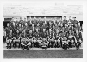
Regional Commissioners Photos
https://search.heritageburnaby.ca/link/archivedescription55156
- Repository
- City of Burnaby Archives
- Date
- 1964-1972
- Collection/Fonds
- Burnaby Historical Society fonds
- Description Level
- File
- Physical Description
- 8 photographs : b&w ; 20 cm x 26 cm and smaller
- Scope and Content
- Photographs of Boy Scout regional commissioners and presidents, including: A.G. "Lofty" Coning, Alan Stan Fisher, Donald S. Murray, Lawrence G. Goulet, and Clifford J. Murane." Two of the men photographed are unidentified.
- Repository
- City of Burnaby Archives
- Date
- 1964-1972
- Collection/Fonds
- Burnaby Historical Society fonds
- Subseries
- Burnaby Scouts subseries
- Physical Description
- 8 photographs : b&w ; 20 cm x 26 cm and smaller
- Description Level
- File
- Record No.
- 631-038
- Access Restriction
- No restrictions
- Reproduction Restriction
- Reproduce for fair dealing purposes only
- Accession Number
- BHS1994-05
- Scope and Content
- Photographs of Boy Scout regional commissioners and presidents, including: A.G. "Lofty" Coning, Alan Stan Fisher, Donald S. Murray, Lawrence G. Goulet, and Clifford J. Murane." Two of the men photographed are unidentified.
- Names
- Boy Scouts of Canada
- Media Type
- Photograph
- Notes
- Label adhered to recto of 631-038-1 reads: "A.G. "Lofty" Coning First President Buranby Region Council, January '63-April '64"
- Label adhered to verso of 631-038-2 reads: "Alan Dawson, Regional Commissioner, Burnaby Region, No. '64-March '67"
- Note in pencil on verso of 631-038-3 reads: "Stan Fisher Regional Commissioner"
- Label for 631-038-4 read: "Donald S. Murray Regional Commission, Burnaby Region, March '70-March '72"
- Label for 631-038-6 read: "Lawrence G. Goulet Regional President, Burnaby Region, March '68-March '70"
- Label for 631-038-7 read: "Clifford J. Murnane, Regional President, Burnaby Region. March '70-March '72"
Images
![Survey and Subdivision plans in New Westminster District Group 1 & Group 2 - Port Moody, Surrey
, [1898-1910] thumbnail](/media/hpo/_Data/_BVM_Cartographic_Material/1977/1977_0093_0073_001.jpg?width=280)
Survey and Subdivision plans in New Westminster District Group 1 & Group 2 - Port Moody, Surrey
https://search.heritageburnaby.ca/link/museumdescription7042
- Repository
- Burnaby Village Museum
- Date
- [1898-1910]
- Collection/Fonds
- Burnaby Village Museum Map collection
- Description Level
- File
- Physical Description
- 10 plans : graphite and ink on paper and linen; various sizes mounted on 2 sides of cardboard 76 x 102 cm
- Scope and Content
- File consists of a large board with four plans in New Westminster District mounted on one side and six plans mounted on the other side. Side A: 1. Plan : black ink and graphite on paper ; 46.5 x 37.5 cm. Title reads: "Bon Accord Hatchery / Sec 6 B5N R1W". Signed by Albert J. Hill P.L.S. August 1…
- Repository
- Burnaby Village Museum
- Collection/Fonds
- Burnaby Village Museum Map collection
- Description Level
- File
- Physical Description
- 10 plans : graphite and ink on paper and linen; various sizes mounted on 2 sides of cardboard 76 x 102 cm
- Material Details
- Scales vary (One chain equals 792 inches)
- Indexed number on tape on edge of board reads "73"
- Scope and Content
- File consists of a large board with four plans in New Westminster District mounted on one side and six plans mounted on the other side. Side A: 1. Plan : black ink and graphite on paper ; 46.5 x 37.5 cm. Title reads: "Bon Accord Hatchery / Sec 6 B5N R1W". Signed by Albert J. Hill P.L.S. August 12, 1903. Plan covers land identified as Section 6, Section 7, Located along the south shore of the Fraser River in Port Mann (Geographic location: Surrey). 2. Plan : black ink and graphite on paper ; 36 x 31 cm. Title reads: "Survey of Portions of Sec. 20 B5N R2W". Plan is stamped in red ink: "Albert J. Hill, Civil Engineer". Scale 4 chains = 1 inch. 3. Plan : black ink on linen ; 14 x 23 cm. Title reads:"Port Moody". Plan covers sections in Lot 191 (District Lot 191) bordered by Burrard Inlet to the west and Lot 235 and Lot 233 to the south. Streets identified include Water Street, Beauregard Street, Yonge Street, Clinton Street and Oxford Street. 4. Plan: graphite and ink on paper ; 43.5 x 64.5 cm. Title reads: "Sketch Plan Approved by Council [sic] / _[sic]1898". (No identifying geographic landmarks provided) Side B: 1. Plan : graphite on paper ; 53.5 x 31 cm. Title reads: "Plan of Lot 13, Gr. II, N.W. Dist". Sketch plan covers area along the Fraser River in District Lot 13, New Westminster District, Group 2. District Lot 13 is bordered by District Lot 14 (to the west) and Lot 12 (to the east). Natural geographic features within District Lot 13 are noted as "dense brush and fallen timber / sallal / rough spruce and cedar / swamp / fine alder / sallal / fine alder bottom land / fine brook". Scale: 3 chains = 1 inch (Geographic location: Surrey) 2. Plan : black ink on paper ; 50.5 x 34.5 cm. Title reads: "Indian Reserve / Opposite / New Westminster". Plan covers area on the south shore of the Fraser River in New Westminster District Group 2 in an area known as Brownsville. Lots are identified as District Lots 1, 2, 3, 4, 18, 17 and 8 and Sections A and B. Two areas of land are noted as "Indian Reserve"; one 6.3 acre parcel and one 104.25 acre parcel, both within District Lot 1. Note on plan reads: "N.B. this plan shows reserves and adjacent properties as they are on the ground". (Geographic location: Surrey) 3. Plan : black and col. ink on paper ; 19.5 x 31.5 cm. Title reads: "Bon Accord Road". Plan shows elevation. "Average section 10 feet = 1 inch". Plan is stamped in red ink: "Albert J. Hill, Civil Engineer and Provincial Land Surveyor, New Westminster, B.C." (Geographic location: Surrey) 4. Plan : black and col. ink on linen ; 16.5 x 25.5 cm. (no formal title) Plan covers area of Section 35, south of Yale Wagon Road and east of Quible Road. Plan is signed by "Albert J. Hill / B.C.L.S." (Geographic location: Surrey) 5. Plan: black and col. ink on linen ; 22.5 x 22.5 cm. (no formal title) Plan covers area between Yale Road and Townline Road in Surrey. Scale: 4 chains = 1 inch. Plan is signed by Albert J. Hill B.C.L.S. [190-] (Geographic location: Surrey) 6. Plan : graphite on paper ; 24 x 54 cm. (no formal title) Plan covers sectioned areas along Bon Accord Road. Sections are identified as " Sec. 8 / T.F. Patterson"; "Sec. 9 / Russell"; "Elliott_Burnett_Crean / Sec. 16"; "Dom. Govt. / Sec. 17". (Geographic location: Surrey, beneath the Port Mann bridge)
- Names
- ʷməθkʷəy̓əm (Musqueam)
- Accession Code
- HV977.93.73
- Access Restriction
- No restrictions
- Reproduction Restriction
- No known restrictions
- Date
- [1898-1910]
- Media Type
- Cartographic Material
- Scan Resolution
- 600
- Scan Date
- 2023-06-26
- Notes
- Title based on contents of file
- Note re plan 2B: The sight of Brownsville was also the former site of the Qayqayt First Nation and one of the main summer villages of the Kwantlen and ʷməθkʷəy̓əm (Musqueam) peoples
Zoomable Images
![Survey and Subdivision plans in New Westminster District Group 1 & Group 2 - Port Moody, Surrey
, [1898-1910] thumbnail](/media/hpo/_Data/_BVM_Cartographic_Material/1977/1977_0093_0073_003_seadragon/1977_0093_0073_003.jpg?w=280)
Survey and Subdivision plans in New Westminster District Group 1 & Group 2 - Port Moody, Surrey , [1898-1910]
Zoom into Image
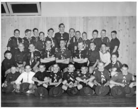
Queen Scout ceremony photographs
https://search.heritageburnaby.ca/link/archivedescription55152
- Repository
- City of Burnaby Archives
- Date
- 1961-1980
- Collection/Fonds
- Burnaby Historical Society fonds
- Description Level
- File
- Physical Description
- 25 photographs : b&w ; 25 cm x 20 cm and smaller
- Scope and Content
- Photographs of the Queen Scout award ceremony and series of Scout troop group portraits.
- Repository
- City of Burnaby Archives
- Date
- 1961-1980
- Collection/Fonds
- Burnaby Historical Society fonds
- Subseries
- Burnaby Scouts subseries
- Physical Description
- 25 photographs : b&w ; 25 cm x 20 cm and smaller
- Description Level
- File
- Record No.
- 631-034
- Access Restriction
- No restrictions
- Reproduction Restriction
- Reproduce for fair dealing purposes only
- Accession Number
- BHS1994-05
- Scope and Content
- Photographs of the Queen Scout award ceremony and series of Scout troop group portraits.
- Names
- Boy Scouts of Canada
- Media Type
- Photograph
- Photographer
- Gibson, Wilfred
- Notes
- Transcribed title
- Title transcribed from envelope in which photographs were originally housed
- Photographer's stamp on verso of all photographs in file: "Gibson's Studio Photographers 819 Broughton St. Victoria, B.C."
- Note in blue ink on recto of 631-034-14 reads: "Reversed as for your [illegible] (new"). Note in blue ink on verso reads: "As you can see - everything is reversed. Whoever said the original prints were printed wrong are wrong themselves. Will Gilin" Note in pencil on verso reads: "Troop #3".
- Note in blue ink on recto of 631-034-15 reads: "New one." Note in blue ink on verso reads: "As per your request this print is reversed. As you can see every-thing is backward. Will Gilin." Note in pencil on verso reads: "Troop #1".
- Note in pencil on verso of 631-034-23 reads: "Scotish Jamoree 75-80?". Notes on verso in pencil and ink identify individuals in photograph: Fred Otte, Gary Otte, Roger Gallaway, Dennis Moore, Jan [illegible], Barkley Ellsworth, Louis MacKinnon, Nigel Tennesan, Ron Murdoch, Fred Smith, Craig Smith, JOhn Steeves, and Wayne Vogan.
Images

![Survey and Subdivision plans in New Westminster District Group 1 – Burnaby, Port Moody, [1862-1908] thumbnail](/media/hpo/_Data/_BVM_Cartographic_Material/1977/1977_0093_0026a_001.jpg?width=280)
Survey and Subdivision plans in New Westminster District Group 1 – Burnaby, Port Moody
https://search.heritageburnaby.ca/link/museumdescription6995
- Repository
- Burnaby Village Museum
- Date
- [1862-1908]
- Collection/Fonds
- Burnaby Village Museum Map collection
- Description Level
- File
- Physical Description
- 9 plans : 6 plans : black ink on paper ; 57 x 36.5 cm or smaller + 1 plan : black ink and grahite on paper ; 46.5 x 49 cm + 1 plan : blueprint on paper ; 15.5 x 19.5 cm + cm + 1 plan : graphite on paper ; 25 x 17 cm ; mounted on both sides of board 76 x 102 cm
- Scope and Content
- Item consists of a large board of four New Westminster District subdivision plans mounted on one side and five New Westminster District subdivision plans mounted on the other side. Side A: 1. "Plan / of Subdivision / of a Portion / of / Lot 87 / Group One / New Westminster District / Scale 4 chs…
- Repository
- Burnaby Village Museum
- Collection/Fonds
- Burnaby Village Museum Map collection
- Description Level
- File
- Physical Description
- 9 plans : 6 plans : black ink on paper ; 57 x 36.5 cm or smaller + 1 plan : black ink and grahite on paper ; 46.5 x 49 cm + 1 plan : blueprint on paper ; 15.5 x 19.5 cm + cm + 1 plan : graphite on paper ; 25 x 17 cm ; mounted on both sides of board 76 x 102 cm
- Material Details
- Scales [between 1:792 and 1:3600]
- Index number on edge of board reads: "26"
- Scope and Content
- Item consists of a large board of four New Westminster District subdivision plans mounted on one side and five New Westminster District subdivision plans mounted on the other side. Side A: 1. "Plan / of Subdivision / of a Portion / of / Lot 87 / Group One / New Westminster District / Scale 4 chs = 1 in". Plan is stamped: "Albert J. Hill, Civil Engineer / and / Provincial Land Surveyor, / New Westminster, / B.C." and intialed by: "RB" [sic] (in blue pencil crayon). Names two of the subdivisons of District Lot 87 are identified as, "L.E. Sprott" and "John Ledger". (Geographic location: Burnaby) 2. "Plan of Subdivision / of / Portions of / Lot 136, 131 and Lots 44 and 78 Gr.1 / New Westminster District / Scale 300 ft = 1 inch". Annotation above title reads: "No. 901 / Deposited in Land Registry Office / New Westminster / Aug. 19th 1905 / Charles S. Keith D. Reg." Annotations and signatures at bottom of plan read: "I, William Nelson Draper, / W.H.R. Collister / Charles E. Perkins / E.B. Morgan / make / Surveys / correct / representation / upon / the / Land Registry Act / (sgd) W.N. Draper, P.L.S.". Plan includes a handwritten title: "Lots 136, 131, 44 & 78" and is initialed: "RB" [sic] (in blue pencil crayon) (Geographic location: Burnaby) 3. "Survey / of / a Portion / of / Lot 95, Gr.1 / Scale 1 ch = 1in." Plan is stamped: "Albert J. Hill, Civil Engineer / and / Provincial Land Surveyor, / New Westminster, / B.C." and is initialed : "RB" [sic] (in blue pencil crayon) (Geographic location: Burnaby) 4. Blueprint plan of "Lot 396. Group One." with Scale : 3 chs = 1 in. A two acre portion of District Lot 396 is filled in with red ink." Plan is signed by "Albert J. Hill / B.C.L.S." (Geographic location: Port Moody) Side B: 1. Plan titled "District Lot 92 / Burnaby / Municipality / for sale by / Mahon / McFarland & / Mahon Ltd. / Vancouver, B.C. / Scale : 4 chains to one inch". District Lot 92 is subdivided into 161 lots and identifies roads: Norwich Road, Pole Line Road, Oakland Road, Stanley Road, Burford Road, Dalhousie Road, Brantford Road, Colborne Road, Roberts Road, Vancouver & Westminster Road, B.C. Electric Railway, Gilley Stn. and Burnaby (Power House). The bottom of the plan reads: "G.S. Dawson, P.LS. Vancouver, B.C." (Geographic location: Burnaby) 2. "Plan / of Subdivision / of a Portion / of / Lot 29 / Group 1 / New Westminster District / Scale 2 chs = 1 in". Plan is stamped: "Albert J. Hill, Civil Engineer / and / Provincial Land Surveyor, / New Westminster, / B.C." and is initialed by: "RB" [sic] (in blue pencil crayon) (Geographic location: Burnaby) 3. Small handrawn plan (no title) identifying "Lot 84 / Hydes, Claim" at the centre surrounded by lots and features identified as: "Lot 85", "Lot 93", "Lot 94", "Lot 32", "Lot 82", "Lot 83", "Lot 79", "swamp" and a "Small Lake" (Burnaby Lake). Identifying marks in the right corner of the plan read: "Page 13 / Surveyed by G. Turner / May 62". Plan also includes surveyor's bearing measurements and trails to "Small Lake" (Burnaby Lake). (Geographic location: Burnaby) 4. Untitled plan showing District Lots west of North Road and north of Burnaby Lake including: Lots 2, 4, 6, 8, 15, 10, 56, 148, 57, 58, 40. and Lots 3, 5, 7 east of North Road (Coquitlam). Lots in Burnaby are identifed for timber including: "Heavily Timbered" (Lot 57), " "Some Fir and Cedar" (Lot 40), "Splendid Fir and Cedar" (Lot 143), "Heavy Fir etc" (Lots 143 and 148), " "Fine Cedar" (Lot 15), "Rough Light Timber" (Lot 56). Other features identified at the lower portion of the plan include "Burnaby Lake" and "Brunette River". (Geographic location: Burnaby) 5. Untitled plan drawn in graphite showing sections of District Lot 85 south of Burnaby Lake and north of Hazsard Road. Plan is signed: "Albert J. Hill / B.C.L.S." and dated "12/26/08". Plan is initialed by: "RB" [sic] (in blue pencil crayon) (Geographic location: Burnaby)
- Publisher
- Mahon, McFarland & Mahon Ltd
- Accession Code
- HV977.93.26
- Access Restriction
- No restrictions
- Reproduction Restriction
- No known restrictions
- Date
- [1862-1908]
- Media Type
- Cartographic Material
- Historic Neighbourhood
- Burnaby Lake (Historic Neighbourhood)
- Burquitlam (Historic Neighbourhood)
- Planning Study Area
- Burnaby Lake Area
- Scan Resolution
- 300
- Scale
- 72
- Notes
- Title based on contents of file
- Scale is measured in chains and feet. (One chain equals 792 inches)
- The term "Lot" can also refer to a "District Lot”
Images
![Survey and Subdivision plans in New Westminster District Group 1 – Burnaby, Port Moody, [1862-1908] thumbnail](/media/hpo/_Data/_BVM_Cartographic_Material/1977/1977_0093_0026a_001.jpg)


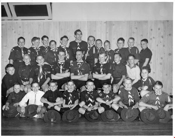
Troup photographs
https://search.heritageburnaby.ca/link/archivedescription55157
- Repository
- City of Burnaby Archives
- Date
- 1969-1975
- Collection/Fonds
- Burnaby Historical Society fonds
- Description Level
- File
- Physical Description
- 16 photographs : b&w and col. ; 18 cm x 23 cm and smaller
- Scope and Content
- Group portraits of various Boy Scout troops including: 1st Southview Cub Pack, 5th Burnaby West, 5th Burnaby Heights Troop, 5th Burnaby West Nootka Wolf Cub Pack, and 7th West Cubs. The portrait of 1st Southview Cub Pack is adhered to paper along with a green and red Boy Scouts badge. File also i…
- Repository
- City of Burnaby Archives
- Date
- 1969-1975
- Collection/Fonds
- Burnaby Historical Society fonds
- Subseries
- Burnaby Scouts subseries
- Physical Description
- 16 photographs : b&w and col. ; 18 cm x 23 cm and smaller
- Description Level
- File
- Record No.
- 631-039
- Access Restriction
- No restrictions
- Reproduction Restriction
- Reproduce for fair dealing purposes only
- Accession Number
- BHS1994-05
- Scope and Content
- Group portraits of various Boy Scout troops including: 1st Southview Cub Pack, 5th Burnaby West, 5th Burnaby Heights Troop, 5th Burnaby West Nootka Wolf Cub Pack, and 7th West Cubs. The portrait of 1st Southview Cub Pack is adhered to paper along with a green and red Boy Scouts badge. File also includes photographs of Scouts and leaders participating in activities including camping and rock climbing and one photograph of Cub Scouts meeting Queen Elizabeth II.
- Names
- Boy Scouts of Canada
- Media Type
- Photograph
- Notes
- Photographer's stamp on verso of photograph 631-039-1 reads: "William Stanley Photographer [contact information]"
- Note in pencil on verso of 631-039-2 reads: "1st Southview"
- Identification key for 631-039-3 located in accession file. Key titled "Boy Scouts of Canada 5th Burnaby West 1974-1975"
- Identification key for 631-039-5 located in accession file. Key titled "Geological Tour - U.S. Sept. 4-5-6, 1971 / 5th Burnaby Heights Troop - taken at "Summer Falls, Wash."
- Identification key attached to 631-039-6. Key titled "Boy Scouts of Canada 5th Burnaby West / 1972-1973"
- Identification key attached to 631-039-7. Key titled "Boy Scouts of Canada 5th Burnaby West / 1974-1975"
- Identification key for 631-039-8 located in accession file. Key titled "Boy Scouts of Canada 5th Burnaby West Nootka Wolf Cub Pack / 1972-1973"
- Note in blue ink on recto of 631-039-9 reads: "5th Burnaby West 1974-1975"
- Identification key for 631-039-10 located in accession file. Key titled "7th West Cubs"
- Photographer's stamp on verso of 631-03-11 reads: "Vancouver Sun Photo Copyright further publication forbidden without permission"
- Sticky note adhered to verso of 631-036-12 read: "Camp Byng".
- Note in pencil on verso of 631-039-14 reads: "Christmas 1969 / Burnie Short June Kinnear Betty Forbes"
Images
Hazel Peterson photographs
https://search.heritageburnaby.ca/link/archivedescription62794
- Repository
- City of Burnaby Archives
- Date
- [1880-2000]
- Collection/Fonds
- Burnaby Historical Society fonds
- Description Level
- File
- Physical Description
- ca. 60 photographs : b&w and col. -- 2 prints : col. illustrations
- Scope and Content
- File consists of loose photographs of Hazel Peterson (nee Erickson), as well as photographs of her family and parents, Charles and Amanda Erickson, and her husband, Edwin Peterson. Photographs are from all stages of Hazel Peterson's life, including infancy and childhood and later years of her life,…
- Repository
- City of Burnaby Archives
- Date
- [1880-2000]
- Collection/Fonds
- Burnaby Historical Society fonds
- Subseries
- Hazel Peterson subseries
- Physical Description
- ca. 60 photographs : b&w and col. -- 2 prints : col. illustrations
- Material Details
- Some photographs remain in frames or paper covers.
- Description Level
- File
- Record No.
- 504-001
- Access Restriction
- No restrictions
- Reproduction Restriction
- No restrictions
- Accession Number
- BHS2000-08
- Scope and Content
- File consists of loose photographs of Hazel Peterson (nee Erickson), as well as photographs of her family and parents, Charles and Amanda Erickson, and her husband, Edwin Peterson. Photographs are from all stages of Hazel Peterson's life, including infancy and childhood and later years of her life, including a trip to Hawaii in 1982. File includes studio portraits, cartes de visites, postcards, and some illustrations.
- Subjects
- Travel
- Persons - Children
- Media Type
- Photograph
- Notes
- Title based on content of file
- Note on verso of 504-022 reads: "This was taken several years ago / Your niece / Hazel Petersen (at left)"
- Note on verso of 504-027 reads: "Hazel Erickson Peterson"
- Note on verso of 504-028 reads: "all of us except Ethel" and identifies the siblings in the photo
- Note on verso of 504-029 reads: "not such a bad picture considering" and identifies the people in the photo.
- Note on verso of 504-030 reads: "Agnus McDonald" and "Touch up outline of deer"
- Note on envelope for 504-039:504-041 reads: "Hazel Petersen resided at Dania Home, Burnaby, for 20 years before her death shortly before her 100th birthday."
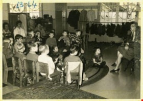
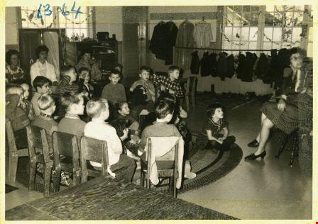
Story time with Mrs. Brown
https://search.heritageburnaby.ca/link/archivedescription52981
- Repository
- City of Burnaby Archives
- Date
- April 27, 1964
- Collection/Fonds
- Burnaby Historical Society fonds
- Description Level
- Item
- Physical Description
- 1 photograph : b&w ; 7.5 x 10.5 cm
- Scope and Content
- Photograph of the Tinkerbell Cooperative Kindergarten class listening to Mrs. Brown read to them for story time. The kindergartners are sitting in chairs in a half circle and on the floor in front.
- Repository
- City of Burnaby Archives
- Date
- April 27, 1964
- Collection/Fonds
- Burnaby Historical Society fonds
- Subseries
- Tinkerbell Kindergarten subseries
- Physical Description
- 1 photograph : b&w ; 7.5 x 10.5 cm
- Description Level
- Item
- Record No.
- 246-021
- Access Restriction
- No restrictions
- Reproduction Restriction
- Reproduce for fair dealing purposes only
- Accession Number
- BHS1990-12
- Scope and Content
- Photograph of the Tinkerbell Cooperative Kindergarten class listening to Mrs. Brown read to them for story time. The kindergartners are sitting in chairs in a half circle and on the floor in front.
- Media Type
- Photograph
- Notes
- Title based on contents of photograph
- Note on recto of photograph reads: "63 - 64"
- Stamp on recto of photograph reads: "M119C / GAGEL FOTO / SERVICE / 27.4.64"
- Handwritten note attached to paper mount reads: "We enjoy story time / Mrs. Brown reads to us."
- Geographic Access
- Ellesmere Avenue
- Hastings Street
- Street Address
- 300 Ellesmere Avenue North
- Historic Neighbourhood
- Capitol Hill (Historic Neighbourhood)
- Planning Study Area
- Capitol Hill Area
Images

Knight family photographs
https://search.heritageburnaby.ca/link/archivedescription64501
- Repository
- City of Burnaby Archives
- Date
- 1948-1971
- Collection/Fonds
- Burnaby Historical Society fonds
- Description Level
- File
- Physical Description
- 49 photographs (35 prints : b&w and col. and 14 negatives : b&w)
- Scope and Content
- Photographs of "the Bird Doctor" Virginia Knight and her husband Milton and their properties, avaries, and pets. File also includes the couple's travel photographs, photograph's of Milton's antique clock and watch collection, and images of Lakeview Aviaries in Burnaby.
- Repository
- City of Burnaby Archives
- Date
- 1948-1971
- Collection/Fonds
- Burnaby Historical Society fonds
- Subseries
- Knight family subseries
- Physical Description
- 49 photographs (35 prints : b&w and col. and 14 negatives : b&w)
- Description Level
- File
- Record No.
- 510-001
- Access Restriction
- No restrictions
- Reproduction Restriction
- May be restricted by third party rights
- Accession Number
- BHS1992-53
- Scope and Content
- Photographs of "the Bird Doctor" Virginia Knight and her husband Milton and their properties, avaries, and pets. File also includes the couple's travel photographs, photograph's of Milton's antique clock and watch collection, and images of Lakeview Aviaries in Burnaby.
- Media Type
- Photograph
- Notes
- Title based on contents of photographs
- Stamp on verso of 510-001 reads: "Woodward's Advertising Photography"
- Note on verso of 510-003 reads: "Taken at San Juan Capistrano. The minute you enter the place these pigeons light all over you and they sell you small bags of wheat to feed them." Other notes and date stamp on verso.
- Note on verso of 510-010 reads: "Virgie + Sheila Joan (Easton) Mulliner / New Year's Eve / 1970-71"
- 510-008, 510-009, 510-011, 510-012: Date stamp on verso reads "Jan 12, 1962"
- Note on verso of 510-022 reads: "My little Saw-Whet Owl who was one of my patients. Fully recovered and hand tame."
- 510-024 is five small photographs glued to a black paper album page
- Handwritten notes on recto of 510-032, describing the clocks in the photograph.
- Geographic Access
- Deer Lake
- Street Address
- 5255 Sperling Avenue
- Historic Neighbourhood
- Burnaby Lake (Historic Neighbourhood)
- Planning Study Area
- Burnaby Lake Area
Images

![Lloyd Costley, [between 1950 and 1970] thumbnail](/media/Hpo/_Data/_Archives_Images/_Unrestricted/126/142-011.jpg?width=280)
Lloyd Costley
https://search.heritageburnaby.ca/link/archivedescription97577
- Repository
- City of Burnaby Archives
- Date
- [between 1950 and 1970]
- Collection/Fonds
- Burnaby Historical Society fonds
- Description Level
- Item
- Physical Description
- 1 photographs : b&w ; 13 cm x 11 cm
- Scope and Content
- Studio portrait of Lloyd Costley.
- Repository
- City of Burnaby Archives
- Date
- [between 1950 and 1970]
- Collection/Fonds
- Burnaby Historical Society fonds
- Subseries
- Burnaby Clef Society subseries
- Physical Description
- 1 photographs : b&w ; 13 cm x 11 cm
- Description Level
- Item
- Record No.
- 142-011
- Reproduction Restriction
- Reproduce for fair dealing purposes only
- Accession Number
- BHS1985-12
- Scope and Content
- Studio portrait of Lloyd Costley.
- Subjects
- Documentary Artifacts - Portraits
- Names
- Burnaby Clef Society
- Media Type
- Photograph
- Notes
- Note in pencil on verso reads: "Mr. Costley's Dedication Picture what size?"
- Note in black ink on verso reads: "Same size as valedictorians pictures"
- Note in pencil on verso reads: "20"
- Photo originally housed in a yellow envelope with note on recto that read: "Lloyd Costleys photo - Mr McLuckie has promised to write the article - Anne Costley will know how you can get in touch with Mr McLukie -".
Images
![Lloyd Costley, [between 1950 and 1970] thumbnail](/media/Hpo/_Data/_Archives_Images/_Unrestricted/126/142-011.jpg)
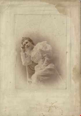
Louisa Sophia "Lou" Jones Vidal
https://search.heritageburnaby.ca/link/archivedescription82349
- Repository
- City of Burnaby Archives
- Date
- [1894]
- Collection/Fonds
- Hill family and Vidal family fonds
- Description Level
- Item
- Physical Description
- 1 photograph : sepia ; 15.5 x 11 cm
- Scope and Content
- Photograph is a portrait of a young woman identified as Louisa Sophia "Lou" Jones Vidal.
- Repository
- City of Burnaby Archives
- Date
- [1894]
- Collection/Fonds
- Hill family and Vidal family fonds
- Physical Description
- 1 photograph : sepia ; 15.5 x 11 cm
- Description Level
- Item
- Record No.
- 550-011
- Access Restriction
- No restrictions
- Reproduction Restriction
- No known restrictions
- Accession Number
- 2013-03
- Scope and Content
- Photograph is a portrait of a young woman identified as Louisa Sophia "Lou" Jones Vidal.
- Media Type
- Photograph
- Notes
- Title based on caption accompanying photograph
- Note in black pen on verso reads: "Louisa Vidal (Jones)"
- Note in blue pen on verso reads: "Lesley's Gan"
- Note in pencil on verso reads: "b. 1870 / d. 1943"
- Photograph stamp on recto reads: "Zweifel Duluth / Cramer Prize, St. Louis Photo Convention 1894"
- Note in pencil on album page reads: "Louisa Sophia Jones / 1875-1943" (verso of paper to which 550-007:550-010 were attached)
Images

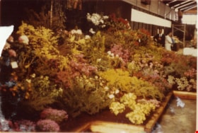
1st Annual Burnaby Rhododendron and Spring Flower Show photographs
https://search.heritageburnaby.ca/link/archivedescription91570
- Repository
- City of Burnaby Archives
- Date
- May 1969
- Collection/Fonds
- Doreen Lawson fonds
- Description Level
- File
- Physical Description
- 13 photographs : col. ; 9 cm x 12.5 cm and smaller
- Scope and Content
- File consists of photographs of the first annual Burnaby Rhododendron and Spring Flower Show. Photographs depict various exhibitors' displays, including the BC Nursery Trade Society, Planned Parenthood, Board of Parks and Public Recreation (City of Vancouver), and Burnaby Parks and Recreation.
- Repository
- City of Burnaby Archives
- Date
- May 1969
- Collection/Fonds
- Doreen Lawson fonds
- Physical Description
- 13 photographs : col. ; 9 cm x 12.5 cm and smaller
- Description Level
- File
- Record No.
- 605-006
- Access Restriction
- No restrictions
- Reproduction Restriction
- Reproduce for fair dealing purposes only
- Accession Number
- 2003-30
- Scope and Content
- File consists of photographs of the first annual Burnaby Rhododendron and Spring Flower Show. Photographs depict various exhibitors' displays, including the BC Nursery Trade Society, Planned Parenthood, Board of Parks and Public Recreation (City of Vancouver), and Burnaby Parks and Recreation.
- Names
- Lawson, Doreen A.
- Media Type
- Photograph
- Photographer
- Brandson, Lloyd S.
- Knudson, Art
- Notes
- Title based on contents of photographs
- Note in blue ink on verso of photograph 605-006-1 reads: "Burnaby Centennial Committee / 25.00 / Doug Earlaw"
- Note in pencil on verso of photographs 605-006-3 : 605-006-6 reads: "Lloyd. S. Brandson / [address] / [phone]
- Note in blue ink on verso of photograph 605-006-7 reads: ""Golden Sunset" / Art Knudson / [address] / [phone]"
- Note in blue ink on verso of photograph 605-006-13 reads: "Art Knudson / [contact information
Images

![Brownie training, [between 1958 and 1960] thumbnail](/media/hpo/_data/_BVM_Images/2015/2015_0035_0252_001.jpg?width=280)
Brownie training
https://search.heritageburnaby.ca/link/museumdescription4894
- Repository
- Burnaby Village Museum
- Date
- [between 1958 and 1960]
- Collection/Fonds
- Burnaby Girl Guides fonds
- Description Level
- Item
- Physical Description
- 1 photograph : b&w ;15.5 x 12 cm
- Scope and Content
- Publicity photograph of "Brownie Training" with a closeup of three women clasping hands together while one of the them holds a pen. Two of the women are dressed as Guide leaders and identified as Mrs. Don Wilks and Mrs. Georgie Runcie.
- Repository
- Burnaby Village Museum
- Collection/Fonds
- Burnaby Girl Guides fonds
- Description Level
- Item
- Physical Description
- 1 photograph : b&w ;15.5 x 12 cm
- Material Details
- Handwritten text in black ink on scrapbook page reads: "Mrs Don Wilks / Mrs Georgie Runcie \ Publicity Photo re- / Brownie / Training / 1958-60".
- Scope and Content
- Publicity photograph of "Brownie Training" with a closeup of three women clasping hands together while one of the them holds a pen. Two of the women are dressed as Guide leaders and identified as Mrs. Don Wilks and Mrs. Georgie Runcie.
- History
- Photograph from the Columbian Newspaper
- Accession Code
- BV015.35.252
- Access Restriction
- No restrictions
- Reproduction Restriction
- May be restricted by third party rights
- Date
- [between 1958 and 1960]
- Media Type
- Photograph
- Scan Resolution
- 600
- Scan Date
- November 7, 2018
- Scale
- 100
- Photographer
- King, Basil
- Notes
- Title based on caption of photograph
- Stamp on verso of photograph reads: Columbian Photo / Basil King / Columbian Photo / RM.5 / 35 Sixth St. New Westminster B.C. / LA 1-2622--6"
- Note in pencil on verso of photograph reads: "B6 / Commissioner 1951-60"
- Note in blue ink on verso of photograph reads: "Mrs. Welks re / Mrs. George [Runcey] [sic]"
- Photograph is a part of page 45 of scrapbook "Burnaby Girl Guides (pg 39). -- [1914]-1969, predominant ca. 1920" (BV.015.35.164)
Images
![Brownie training, [between 1958 and 1960] thumbnail](/media/hpo/_data/_BVM_Images/2015/2015_0035_0252_001.jpg)
Burnaby Clef Society minute book
https://search.heritageburnaby.ca/link/archivedescription57833
- Repository
- City of Burnaby Archives
- Date
- 1967-1975
- Collection/Fonds
- Burnaby Historical Society fonds
- Description Level
- Item
- Physical Description
- 1 file of textual records
- Scope and Content
- File contains Burnaby Clef Society meeting minutes, both handwritten and typed, for 1967-1975.
- Repository
- City of Burnaby Archives
- Date
- 1967-1975
- Collection/Fonds
- Burnaby Historical Society fonds
- Subseries
- Burnaby Clef Society subseries
- Physical Description
- 1 file of textual records
- Description Level
- Item
- Record No.
- MSS020-026
- Accession Number
- BHS1985-12
- Scope and Content
- File contains Burnaby Clef Society meeting minutes, both handwritten and typed, for 1967-1975.
- Media Type
- Textual Record
- Notes
- Title based on contents of item
- Label on original binder housing read: "Minutes of Clef Society of Burnaby 1967-1975"
- Note in black ink on recto of cover of original binder housing read: "Nov 1967 to 1975 Feb"
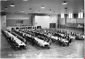
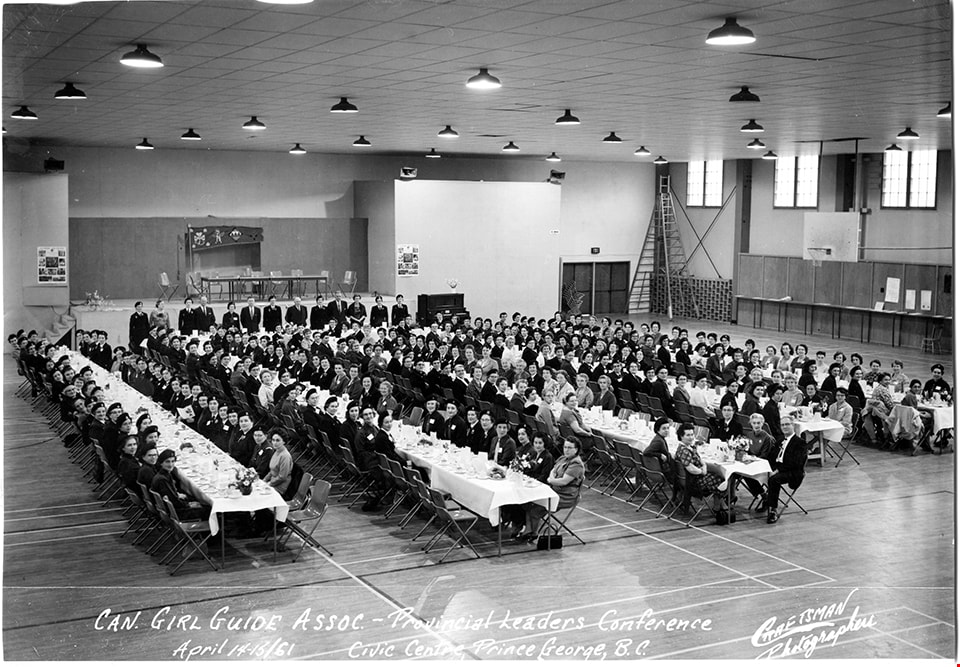
Can. Girl Guide association - Provincial leaders conference
https://search.heritageburnaby.ca/link/museumdescription4901
- Repository
- Burnaby Village Museum
- Date
- Apr 1961
- Collection/Fonds
- Burnaby Girl Guides fonds
- Description Level
- Item
- Physical Description
- 1 photograph : b&w ; 17 x 24.5 cm
- Scope and Content
- Photograph of the Canadian Girl Guide Association- Provincial Leaders conference at the Civic Centre. Prince George, B.C. Girl Guide leaders are seated along five long tables covered with white table cloths inside a large room. Burnaby Girl Guide leaders in attendance are identified as Audrey Park,…
- Repository
- Burnaby Village Museum
- Collection/Fonds
- Burnaby Girl Guides fonds
- Description Level
- Item
- Physical Description
- 1 photograph : b&w ; 17 x 24.5 cm
- Scope and Content
- Photograph of the Canadian Girl Guide Association- Provincial Leaders conference at the Civic Centre. Prince George, B.C. Girl Guide leaders are seated along five long tables covered with white table cloths inside a large room. Burnaby Girl Guide leaders in attendance are identified as Audrey Park, Phyllis Martin, Marg Nelson, Ethel Steele, Eve McLean, Isabelle Roper, Del Carrell, I. Foskie, D. Fowler, Doris Stafford, Ann Dugdale and Molly Daly.
- Names
- Girl Guides of Canada
- Park, Audrey
- Martin, Phyllis
- Nelson, Margaret
- Steele, Ethel
- McLean, Eve
- Roper, Isabelle
- Carrell, Del
- Foskie, I.
- Fowler, Doreen
- Stafford, Doris
- Dugdale, Ann
- Daly, Molly
- Accession Code
- BV015.35.259
- Access Restriction
- No restrictions
- Reproduction Restriction
- May be restricted by third party rights
- Date
- Apr 1961
- Media Type
- Photograph
- Related Material
- Same photograph as BV016.49.111
- Scan Resolution
- 600
- Scan Date
- January 6, 2021
- Scale
- 100
- Photographer
- Craftsman Photographers
- Notes
- Title based on caption of photograph
- Note in ink on verso of photograph reads: "Audrey Park, Phyllis Martin, Marg Nelson, Ethel Steele, Eve McLean / Isobel Roper, Del Carrell, I. Foskie / D. Fowler / Doris Stafford / Ann Dugdale, Molly Daly"
- Stamp on verso of photograph reads: "Craftsman Photographers / 3322-4th Ave Prince George, B.C."
- Caption in white ink at bottom of photograph reads: "Can. Girl Guides Assoc. - Provincial Leaders Conference / April 14-15/61_ Civic Centre, Prince George, B.C. / Craftsmen / Photographers"
- Note in black ink on scrapbook page reads: "Among those attending: Audrey Park, Phyllis Martin, Marg Nelson, Ethel Steele, / Eve McLean, Isobel [sic] Roper, D. Catrell, I. Foskie, D. Fowler, Doris Stafford, Ann Dugdale / and Molly Daly."
- Photograph is a part of scrapbook "Burnaby Girl Guides. -- [1914]-1969, predominant ca. 1920" (BV.015.35.164)
Images
![Girl Guides on steps of Willingdon Heights United Church, [ca. 1960] thumbnail](/media/hpo/_Data/_BVM_Images/2016/2016_0049_0114_001.jpg?width=280)
Girl Guides on steps of Willingdon Heights United Church
https://search.heritageburnaby.ca/link/museumdescription5221
- Repository
- Burnaby Village Museum
- Date
- [ca. 1960]
- Collection/Fonds
- Burnaby Girl Guides fonds
- Description Level
- Item
- Physical Description
- 1 photograph : b&w ; 10.5 x 12.5 cm
- Scope and Content
- Photograph of a North Burnaby group of Girl Guides and leaders dressed in uniforms standing on the steps of Willingdon Heights United Church.
- Repository
- Burnaby Village Museum
- Collection/Fonds
- Burnaby Girl Guides fonds
- Description Level
- Item
- Physical Description
- 1 photograph : b&w ; 10.5 x 12.5 cm
- Scope and Content
- Photograph of a North Burnaby group of Girl Guides and leaders dressed in uniforms standing on the steps of Willingdon Heights United Church.
- Geographic Access
- Parker Street
- Street Address
- 4304 Parker Street
- Accession Code
- BV016.49.114
- Access Restriction
- No restrictions
- Reproduction Restriction
- May be restricted by third party rights
- Date
- [ca. 1960]
- Media Type
- Photograph
- Historic Neighbourhood
- Vancouver Heights (Historic Neighbourhood)
- Planning Study Area
- Willingdon Heights Area
- Notes
- Title based on content of photograph label
- Notes in pencil on verso of photograph read: "C79 5136 [sic] / cy 8 5170 [sic] / 1 / 96888 [sic] / cy_93046[sic]"
- Stamp on verso of photograph reads: "440"[sic]
- Label under photograph in scrapbook reads: "North Burnaby Division / Church Parade"
Images
![Girl Guides on steps of Willingdon Heights United Church, [ca. 1960] thumbnail](/media/hpo/_Data/_BVM_Images/2016/2016_0049_0114_001.jpg)
The Holy Bible, containing the Old and New Testaments : translated out of the original tongues, and with the former translations diligently compared and revised by His Majesty's special command : appointed to be read in churches
https://search.heritageburnaby.ca/link/museumlibrary2601
- Repository
- Burnaby Village Museum
- Collection
- Special Collection
- Material Type
- Book
- Accession Code
- HV975.140.14
- Call Number
- 220 HOL
- Place of Publication
- New York
- Publisher
- Oxford University Press
- Publication Date
- 1899
- Printer
- J.J. Little & Co.
- Physical Description
- 1 v. (multiple pagings) : maps ; 20 cm.
- Inscription
- "Mrs. N.P Nerry, [could also read W.P. Werry] Cedarvill. Ont." [Handwritten in black ink on front flyleaf] "To Mother: with best wishes of Father and Ella, for a Merry Christmas, and Happy New Year Xmax 1899" [Handwritten in black ink on front flylleaf]
- Library Subject (LOC)
- Bible
- Bible. New Testament
- Bible. Old Testament
![Jane Ann Rollason, [1860-1900] thumbnail](/media/hpo/_Data/_Archives_Images/_Unrestricted/550/550-118.jpg?width=280)
Jane Ann Rollason
https://search.heritageburnaby.ca/link/archivedescription82544
- Repository
- City of Burnaby Archives
- Date
- [1860-1900]
- Collection/Fonds
- Hill family and Vidal family fonds
- Description Level
- Item
- Physical Description
- 1 photograph : sepia ; 9.5 x 6 cm + 1 piece of wood
- Scope and Content
- Photograph is a portrait of a woman identified as Jane Ann Rollason.
- Repository
- City of Burnaby Archives
- Date
- [1860-1900]
- Collection/Fonds
- Hill family and Vidal family fonds
- Physical Description
- 1 photograph : sepia ; 9.5 x 6 cm + 1 piece of wood
- Description Level
- Item
- Record No.
- 550-118
- Access Restriction
- No restrictions
- Reproduction Restriction
- No known restrictions
- Accession Number
- 2013-03
- Scope and Content
- Photograph is a portrait of a woman identified as Jane Ann Rollason.
- Media Type
- Photograph
- Notes
- Title based on note accompanying photograph
- Note in pencil on album page reads: "Jane Ann Rollinson / (wife of Richard Hill) / (Grandmother of Minard Hill)
- Note in pencil on verso reads: "Jane Ann nee Rollison (Hill)"
- Photograph stamp on verso reads: "From the Photographic Studio W Sherwoood, / 23 Nook Street, Workincton, / This or ... can be enlar... in oil or water colours. / Negatives ... always be had"
- Note in blue pen on piece of wood taped to the album page reads: "Mother of K Claude Hill B R Hill / Jane Hill Nee Rolston / Grand Mother of K M Peers"
Images
![Jane Ann Rollason, [1860-1900] thumbnail](/media/hpo/_Data/_Archives_Images/_Unrestricted/550/550-118.jpg)
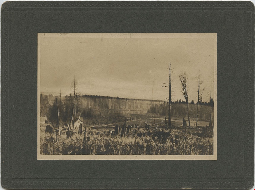
Looking from Woodlunds towards Burnaby Lake in 1899
https://search.heritageburnaby.ca/link/museumdescription992
- Repository
- Burnaby Village Museum
- Date
- 1899
- Collection/Fonds
- Burnaby Village Museum Photograph collection
- Description Level
- Item
- Physical Description
- 1 photograph : sepia photogravure ; 9.8 x 13.9 cm, mounted on cardboard 14.5 x 19.7 cm
- Scope and Content
- Photograph taken from "Woodlunds." Annotations in ink on the back of the card read, "Mr & Mrs G. Every-Clayton/ with Mr Haszard's/ wishes for a very/ Happy Xmas/ 1899" and "Looking from Woodlands / towards Burnaby Lake in 1899." Later annotation in blue ballpoint pen read, "Woodlunds the residence…
- Repository
- Burnaby Village Museum
- Collection/Fonds
- Burnaby Village Museum Photograph collection
- Description Level
- Item
- Physical Description
- 1 photograph : sepia photogravure ; 9.8 x 13.9 cm, mounted on cardboard 14.5 x 19.7 cm
- Scope and Content
- Photograph taken from "Woodlunds." Annotations in ink on the back of the card read, "Mr & Mrs G. Every-Clayton/ with Mr Haszard's/ wishes for a very/ Happy Xmas/ 1899" and "Looking from Woodlands / towards Burnaby Lake in 1899." Later annotation in blue ballpoint pen read, "Woodlunds the residence of Mr. Geo. Every-Clayton stood on the site of the present Centennial Pavilion, which when originally built was the residence of Mr. and Mrs. H.T. Ceperley. The proceeds from its sale was used to prepare the Ceperley playground in Stanley Park. The house in the left centre was that of Mr. and Mrs. Bernard R. Hill demolished to make way for entrance to Expressway."
- Names
- Every-Clayton, George
- Geographic Access
- Burnaby Lake
- Accession Code
- HV973.40.6
- Access Restriction
- No restrictions
- Reproduction Restriction
- No known restrictions
- Date
- 1899
- Media Type
- Photograph
- Scan Resolution
- 600
- Scan Date
- 2023-05-09
- Scale
- 100
- Notes
- Title based on contents of photograph
Images