Narrow Results By
Subject
- Advertising Medium - Signs and Signboards 1
- Aerial Photographs
- Arts - Paintings 1
- Buildings - Commercial - Grocery Stores 1
- Buildings - Commercial - Stores
- Buildings - Industrial - Factories 1
- Buildings - Industrial - Saw Mills 1
- Buildings - Residences - Houses 1
- Buildings - Schools 10
- Celebrations 1
- Crafts 2
- Documentary Artifacts - Books 4
Aerial photograph of North Burnaby
https://search.heritageburnaby.ca/link/archivedescription84881
- Repository
- City of Burnaby Archives
- Date
- 1963
- Collection/Fonds
- Allan Amundsen collection
- Description Level
- Item
- Physical Description
- 1 photograph : b&w ; 22.5 x 22.5 cm
- Scope and Content
- Aerial photograph of North Burnaby with Burrard Inlet to the north and Hastings Street, Inlet Drive, Barnet Road.
- Repository
- City of Burnaby Archives
- Date
- 1963
- Collection/Fonds
- Allan Amundsen collection
- Physical Description
- 1 photograph : b&w ; 22.5 x 22.5 cm
- Description Level
- Item
- Record No.
- 561-002
- Access Restriction
- In Archives only
- Reproduction Restriction
- No reproduction permitted
- Accession Number
- 2014-08
- Scope and Content
- Aerial photograph of North Burnaby with Burrard Inlet to the north and Hastings Street, Inlet Drive, Barnet Road.
- Media Type
- Photograph
- Photographer
- Province of British Columbia
- Notes
- Title based on contents of photograph
- This photo is indentified as BC5061:84 and connects with B.C. air photograph BC5061:85 to the west and BC5061:83 to the east
- Geographic Access
- Burrard Inlet
- Burnaby Mountain Conservation Area
- Historic Neighbourhood
- Capitol Hill (Historic Neighbourhood)
- Lochdale (Historic Neighbourhood)
- Planning Study Area
- Parkcrest-Aubrey Area
- Westridge Area
Aerial photograph of North Burnaby
https://search.heritageburnaby.ca/link/archivedescription93598
- Repository
- City of Burnaby Archives
- Date
- 1963
- Collection/Fonds
- Allan Amundsen collection
- Description Level
- Item
- Physical Description
- 1 photograph : b&w ; 22.5 x 22.5 cm
- Scope and Content
- Aerial photograph of North Burnaby with Burrard Inlet to the north and Hastings Street, Inlet Drive, Barnet Road.
- Repository
- City of Burnaby Archives
- Date
- 1963
- Collection/Fonds
- Allan Amundsen collection
- Physical Description
- 1 photograph : b&w ; 22.5 x 22.5 cm
- Description Level
- Item
- Record No.
- 561-001
- Access Restriction
- In Archives only
- Reproduction Restriction
- No reproduction permitted
- Accession Number
- 2014-08
- Scope and Content
- Aerial photograph of North Burnaby with Burrard Inlet to the north and Hastings Street, Inlet Drive, Barnet Road.
- Media Type
- Photograph
- Photographer
- Province of British Columbia
- Notes
- Title based on contents of photograph
- This photo is identified as BC5061:85
- Geographic Access
- Burrard Inlet
- Burnaby Mountain Conservation Area
- Historic Neighbourhood
- Capitol Hill (Historic Neighbourhood)
- Lochdale (Historic Neighbourhood)
- Planning Study Area
- Parkcrest-Aubrey Area
- Westridge Area
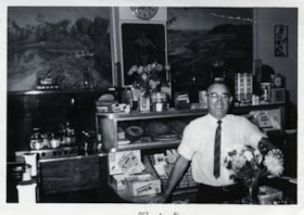
![Harry Royle at Harry's confectionery store, [1961] thumbnail](/media/hpo/_Data/_BVM_Images/2000/200500200008.jpg?width=280)
Harry Royle at Harry's confectionery store
https://search.heritageburnaby.ca/link/museumdescription1882
- Repository
- Burnaby Village Museum
- Date
- [1961]
- Collection/Fonds
- Harry Royle fonds
- Description Level
- Item
- Physical Description
- 1 photograph : b&w ; 7.5 x 9.5 cm
- Scope and Content
- Photograph of Harry Royle standing behind the counter of his confectionery store, "Harry's" at Ellesmere and Hastings in Capitol Hill. He is looking at the camera and smiling, surrounded by various confectionery. There are posters hanging on the wall and trophies displayed on shelves in the backgro…
- Repository
- Burnaby Village Museum
- Collection/Fonds
- Harry Royle fonds
- Description Level
- Item
- Physical Description
- 1 photograph : b&w ; 7.5 x 9.5 cm
- Scope and Content
- Photograph of Harry Royle standing behind the counter of his confectionery store, "Harry's" at Ellesmere and Hastings in Capitol Hill. He is looking at the camera and smiling, surrounded by various confectionery. There are posters hanging on the wall and trophies displayed on shelves in the background.
- Geographic Access
- Hastings Street
- Street Address
- 5527 Hastings Street
- Accession Code
- BV005.20.8
- Access Restriction
- No restrictions
- Reproduction Restriction
- May be restricted by third party rights
- Date
- [1961]
- Media Type
- Photograph
- Historic Neighbourhood
- Capitol Hill (Historic Neighbourhood)
- Planning Study Area
- Capitol Hill Area
- Scan Resolution
- 600
- Scan Date
- 1/12/2010
- Scale
- 100
- Notes
- Title based on contents of photograph
- Stamp on verso of photograph reads: "952D01 POLAROID"
- The Bulova clock hanging on the wall is at 5:49
Images
![Harry Royle at Harry's confectionery store, [1961] thumbnail](/media/hpo/_Data/_BVM_Images/2000/200500200008.jpg)
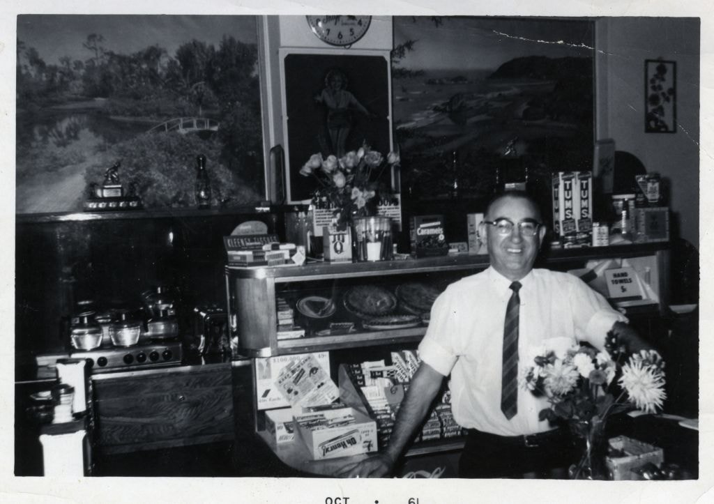
Harry Royle at Harry's confectionery store
https://search.heritageburnaby.ca/link/museumdescription1883
- Repository
- Burnaby Village Museum
- Date
- October 1961
- Collection/Fonds
- Harry Royle fonds
- Description Level
- Item
- Physical Description
- 1 photograph : b&w ; 7.5 x 11.5 cm
- Scope and Content
- Photograph of Harry Royle standing behind the counter of his confectionery store, "Harry's" at Ellesmere and Hastings in Capitol Hill. He is looking at the camera and smiling, surrounded by various confectionery. There are posters hanging on the wall and trophies displayed on shelves in the backgro…
- Repository
- Burnaby Village Museum
- Collection/Fonds
- Harry Royle fonds
- Description Level
- Item
- Physical Description
- 1 photograph : b&w ; 7.5 x 11.5 cm
- Scope and Content
- Photograph of Harry Royle standing behind the counter of his confectionery store, "Harry's" at Ellesmere and Hastings in Capitol Hill. He is looking at the camera and smiling, surrounded by various confectionery. There are posters hanging on the wall and trophies displayed on shelves in the background.
- Geographic Access
- Hastings Street
- Street Address
- 5527 Hastings Street
- Accession Code
- BV005.20.9
- Access Restriction
- No restrictions
- Reproduction Restriction
- May be restricted by third party rights
- Date
- October 1961
- Media Type
- Photograph
- Historic Neighbourhood
- Capitol Hill (Historic Neighbourhood)
- Planning Study Area
- Capitol Hill Area
- Scan Resolution
- 600
- Scan Date
- 1/12/2010
- Scale
- 100
- Notes
- Title based on contents of photograph
- Date stamp on recto of photograph's border reads: "OCT 61"
Images