Narrow Results By
Creator
- Bancroft, Rose 1
- Brown, Donald N. "Don" 1
- Burnett, David H. 1
- Digney, Andy 2
- Digney, Ernest Frank "Dig" 1
- Digney family 1
- Frame, Norvie Leggett 1
- Government of British Columbia - Department of Lands and Works 1
- Hill, Albert James 1
- Martin, George Bohun 1
- McGugan, Donald Johnston 1
- McLean, George H.F. 1

Map of South Western Part of British Columbia
https://search.heritageburnaby.ca/link/museumdescription8688
- Repository
- Burnaby Village Museum
- Date
- 1897
- Collection/Fonds
- Burnaby Village Museum Map collection
- Description Level
- Item
- Physical Description
- 1 map : col. ink on paper ; 68 x 88 cm
- Scope and Content
- Item consists of a "MAP OF THE SOUTH-WESTERN PART OF BRITISH COLUMBIA”. Map identifies geographic land districts of New Westminster District; Coast District; Lillooet District; Yale District, Kamloops Division, Yale Division and districts on Vancouver Island. Map also includes the northern portions…
- Repository
- Burnaby Village Museum
- Collection/Fonds
- Burnaby Village Museum Map collection
- Description Level
- Item
- Physical Description
- 1 map : col. ink on paper ; 68 x 88 cm
- Material Details
- Scale [1:633600]
- Scope and Content
- Item consists of a "MAP OF THE SOUTH-WESTERN PART OF BRITISH COLUMBIA”. Map identifies geographic land districts of New Westminster District; Coast District; Lillooet District; Yale District, Kamloops Division, Yale Division and districts on Vancouver Island. Map also includes the northern portions of the State of Washington below the 49th parallel.
- Publisher
- The Colonist Litho Victoria B.C.
- Responsibility
- Martin, George Bohun
- Accession Code
- BV993.12.12
- Access Restriction
- No restrictions
- Reproduction Restriction
- No known restrictions
- Date
- 1897
- Media Type
- Cartographic Material
- Scan Resolution
- 600
- Scan Date
- 2023-08-17
- Notes
- Transcribed title
- Scale equals 1 inch to 10 miles
- "Compiled and drawn by direction of the Honouable G.B. Martin, Chief Commissioner of Lands and Works, Victoria, B.C."
- Signed by Surveyor General "Tom Kains"
Zoomable Images

![Survey and Subdivision plans in New Westminster District Group 1 & Group 2 - Port Moody, Surrey
, [1898-1910] thumbnail](/media/hpo/_Data/_BVM_Cartographic_Material/1977/1977_0093_0073_001.jpg?width=280)
Survey and Subdivision plans in New Westminster District Group 1 & Group 2 - Port Moody, Surrey
https://search.heritageburnaby.ca/link/museumdescription7042
- Repository
- Burnaby Village Museum
- Date
- [1898-1910]
- Collection/Fonds
- Burnaby Village Museum Map collection
- Description Level
- File
- Physical Description
- 10 plans : graphite and ink on paper and linen; various sizes mounted on 2 sides of cardboard 76 x 102 cm
- Scope and Content
- File consists of a large board with four plans in New Westminster District mounted on one side and six plans mounted on the other side. Side A: 1. Plan : black ink and graphite on paper ; 46.5 x 37.5 cm. Title reads: "Bon Accord Hatchery / Sec 6 B5N R1W". Signed by Albert J. Hill P.L.S. August 1…
- Repository
- Burnaby Village Museum
- Collection/Fonds
- Burnaby Village Museum Map collection
- Description Level
- File
- Physical Description
- 10 plans : graphite and ink on paper and linen; various sizes mounted on 2 sides of cardboard 76 x 102 cm
- Material Details
- Scales vary (One chain equals 792 inches)
- Indexed number on tape on edge of board reads "73"
- Scope and Content
- File consists of a large board with four plans in New Westminster District mounted on one side and six plans mounted on the other side. Side A: 1. Plan : black ink and graphite on paper ; 46.5 x 37.5 cm. Title reads: "Bon Accord Hatchery / Sec 6 B5N R1W". Signed by Albert J. Hill P.L.S. August 12, 1903. Plan covers land identified as Section 6, Section 7, Located along the south shore of the Fraser River in Port Mann (Geographic location: Surrey). 2. Plan : black ink and graphite on paper ; 36 x 31 cm. Title reads: "Survey of Portions of Sec. 20 B5N R2W". Plan is stamped in red ink: "Albert J. Hill, Civil Engineer". Scale 4 chains = 1 inch. 3. Plan : black ink on linen ; 14 x 23 cm. Title reads:"Port Moody". Plan covers sections in Lot 191 (District Lot 191) bordered by Burrard Inlet to the west and Lot 235 and Lot 233 to the south. Streets identified include Water Street, Beauregard Street, Yonge Street, Clinton Street and Oxford Street. 4. Plan: graphite and ink on paper ; 43.5 x 64.5 cm. Title reads: "Sketch Plan Approved by Council [sic] / _[sic]1898". (No identifying geographic landmarks provided) Side B: 1. Plan : graphite on paper ; 53.5 x 31 cm. Title reads: "Plan of Lot 13, Gr. II, N.W. Dist". Sketch plan covers area along the Fraser River in District Lot 13, New Westminster District, Group 2. District Lot 13 is bordered by District Lot 14 (to the west) and Lot 12 (to the east). Natural geographic features within District Lot 13 are noted as "dense brush and fallen timber / sallal / rough spruce and cedar / swamp / fine alder / sallal / fine alder bottom land / fine brook". Scale: 3 chains = 1 inch (Geographic location: Surrey) 2. Plan : black ink on paper ; 50.5 x 34.5 cm. Title reads: "Indian Reserve / Opposite / New Westminster". Plan covers area on the south shore of the Fraser River in New Westminster District Group 2 in an area known as Brownsville. Lots are identified as District Lots 1, 2, 3, 4, 18, 17 and 8 and Sections A and B. Two areas of land are noted as "Indian Reserve"; one 6.3 acre parcel and one 104.25 acre parcel, both within District Lot 1. Note on plan reads: "N.B. this plan shows reserves and adjacent properties as they are on the ground". (Geographic location: Surrey) 3. Plan : black and col. ink on paper ; 19.5 x 31.5 cm. Title reads: "Bon Accord Road". Plan shows elevation. "Average section 10 feet = 1 inch". Plan is stamped in red ink: "Albert J. Hill, Civil Engineer and Provincial Land Surveyor, New Westminster, B.C." (Geographic location: Surrey) 4. Plan : black and col. ink on linen ; 16.5 x 25.5 cm. (no formal title) Plan covers area of Section 35, south of Yale Wagon Road and east of Quible Road. Plan is signed by "Albert J. Hill / B.C.L.S." (Geographic location: Surrey) 5. Plan: black and col. ink on linen ; 22.5 x 22.5 cm. (no formal title) Plan covers area between Yale Road and Townline Road in Surrey. Scale: 4 chains = 1 inch. Plan is signed by Albert J. Hill B.C.L.S. [190-] (Geographic location: Surrey) 6. Plan : graphite on paper ; 24 x 54 cm. (no formal title) Plan covers sectioned areas along Bon Accord Road. Sections are identified as " Sec. 8 / T.F. Patterson"; "Sec. 9 / Russell"; "Elliott_Burnett_Crean / Sec. 16"; "Dom. Govt. / Sec. 17". (Geographic location: Surrey, beneath the Port Mann bridge)
- Names
- ʷməθkʷəy̓əm (Musqueam)
- Accession Code
- HV977.93.73
- Access Restriction
- No restrictions
- Reproduction Restriction
- No known restrictions
- Date
- [1898-1910]
- Media Type
- Cartographic Material
- Scan Resolution
- 600
- Scan Date
- 2023-06-26
- Notes
- Title based on contents of file
- Note re plan 2B: The sight of Brownsville was also the former site of the Qayqayt First Nation and one of the main summer villages of the Kwantlen and ʷməθkʷəy̓əm (Musqueam) peoples
Zoomable Images
![Survey and Subdivision plans in New Westminster District Group 1 & Group 2 - Port Moody, Surrey
, [1898-1910] thumbnail](/media/hpo/_Data/_BVM_Cartographic_Material/1977/1977_0093_0073_003_seadragon/1977_0093_0073_003.jpg?w=280)
Survey and Subdivision plans in New Westminster District Group 1 & Group 2 - Port Moody, Surrey , [1898-1910]
Zoom into Image
![Survey and Subdivision plans in New Westminster District Group 2 - Surrey, Delta
, [1898-1910] thumbnail](/media/hpo/_Data/_BVM_Cartographic_Material/1977/1977_0093_0078_001.jpg?width=280)
Survey and Subdivision plans in New Westminster District Group 2 - Surrey, Delta
https://search.heritageburnaby.ca/link/museumdescription7047
- Repository
- Burnaby Village Museum
- Date
- [1898-1910]
- Collection/Fonds
- Burnaby Village Museum Map collection
- Description Level
- File
- Physical Description
- 10 plans : graphite and ink on paper and linen; various sizes mounted on 2 sides of cardboard 76 x 102 cm
- Scope and Content
- File consists of a large board with four plans in New Westminster District mounted on one side and six plans mounted on the other side. Side A: 1. Plan : black ink on paper with colour (no formal title). Plan covers area in New Westminster District, Group 2 situated along the south shore of the …
- Repository
- Burnaby Village Museum
- Collection/Fonds
- Burnaby Village Museum Map collection
- Description Level
- File
- Physical Description
- 10 plans : graphite and ink on paper and linen; various sizes mounted on 2 sides of cardboard 76 x 102 cm
- Material Details
- Scales vary
- Indexed number on tape on edge of board reads "78"
- Scope and Content
- File consists of a large board with four plans in New Westminster District mounted on one side and six plans mounted on the other side. Side A: 1. Plan : black ink on paper with colour (no formal title). Plan covers area in New Westminster District, Group 2 situated along the south shore of the Fraser River identified as "Indian Reserve / Turner 1868" situated in District Lot 1 between District Lot 2 identified as "Mohun's Line" and "Herring's Line" bordered by lots B and A. Includes note "see plan of subdivision of Lots 3 & 4 Gr. 2". (Geographic location: Surrey) 2. Plan : graphite on paper ; Title reads: "B5N R2W, Sec.26_Sec. 28 / Sec. 35_Sec.36". Plan covers a 60 acre parcel in Sec. 35 with Yale wagon road to the south. Scale: 6 chains = 1 inch (Geographic location: Surrey) 3. Plan : black ink on paper ; Title reads: "Survey for Proposed Highway in Indian Reserve Surrey". Plan covers area of land to the northwest of Lot 2 along the shore of the Fraser River and identfies route of proposed highway, proposed tramway as well at the Great Northern Railway and bridge. Scale: 2 chains = 1 inch 4. Plan : black ink on red lined graphing paper ; Title reads: "Sketch Plan Showing Section of Great Northern R. of W. at Point of Crossing of Proposed Ditch". Plan covers area of Lot 2 in New Westminster District, Group 2. (Surrey) Scale: 1 inch = 5 feet. (Geographic location: Surrey) Side B: 1. Plan : black ink on paper ; Title reads: "Plan of Subdivision of a Portion of Section 13, TP2, Surrey Municipality, New Westminster District, B.C.". Plan covers land bordered by Coast Meridian Road (to the east), Bose Road (to the south) and Pike Road (to the west). Surveyed for D.S. Bayners, Nov. 24, 1908. Scale: 5 chains= 1 inch 2. Plan : black ink on linen with colour ; Title reads: "Traverse of the Waterline in front of Lots 3 and 4, Group 2, New Westminster District with G.N. Railway Right of Way". Plan covers area along the southern shore of the Fraser River with a road crossing the Great Northern Railway and leading to a wharf. Scale: 100 feet = 1 inch (Geographic location: Surrey) 3. Plan : black ink on paper ; Title reads: "Survey of the South Boundary of Sec. 12, Township 2, New Westminster District". Plan covers area south of Bose Road and west of Coast Meridean Road and north of McClellen Road. Scale: 400 feet = 1 inch. Sec.12 (Geographic location: Surrey) 4. Plan : graphite on paper ; Title reads: "Plan of Subdivisioin of a part of S.E. 1/4 of Sec. 7, TP 8". Plan covers area of Section 7 in New Westminster District, Group 2, Township 8. Streets are identified running through lot including, Langley Ave., Robinson Ave, Melrose Ave., Hawthorne Ave., Broadway, Bond Ave., Mable Ave., Breene Ave. and McLelland Ave. and Clover Valley Road. Scale: 200 feet = 1 inch. Note in black ink reads: See Bd. 166 for blue print. (Geographic location: Surrey) 5. Plan : graphite on linen ; Title reads: "Sec.20, B5N R2W". Plan covers area north of Yale Road and is subdivided into parts identified as A, B, C, D, E, and unknown. (Geographic location: Surrey) 6. Plan : black ink and graphite on paper ; (no formal title) Plan covers lots surveyed along Ladner Road identified as A, B and Lots 13, 12 and 11. [Geographic location: Delta]
- Accession Code
- HV977.93.78
- Access Restriction
- No restrictions
- Reproduction Restriction
- No known restrictions
- Date
- [1898-1910]
- Media Type
- Cartographic Material
- Scan Resolution
- 600
- Scan Date
- 2023-06-26
- Notes
- Title based on contents of file
- Note re plans 1A & 3A: The sight of Brownsville was also the former site of the Qayqayt First Nation and one of the main summer villages of the Kwantlen and ʷməθkʷəy̓əm (Musqueam) peoples
- Scale is measured in chains and feet. (One chain equals 792 inches)
Zoomable Images
![Survey and Subdivision plans in New Westminster District Group 2 - Surrey, Delta
, [1898-1910] thumbnail](/media/hpo/_Data/_BVM_Cartographic_Material/1977/1977_0093_0078_003_seadragon/1977_0093_0078_003.jpg?w=280)
Survey and Subdivision plans in New Westminster District Group 2 - Surrey, Delta , [1898-1910]
Zoom into Image
Donald N. Brown subseries
https://search.heritageburnaby.ca/link/archivedescription35
- Repository
- City of Burnaby Archives
- Date
- 1925 (date of original)-1995
- Collection/Fonds
- Burnaby Historical Society fonds
- Description Level
- Subseries
- Physical Description
- Textual records and other material
- Scope and Content
- Subseries consists of photographs taken by Freeman Donald N. Brown while involved in Burnaby Historical Society activities and textual records pertaining to his career with the Royal Canadian Mounted Police. Also included in the subseries are documents and photographs from his involvement with vari…
- Repository
- City of Burnaby Archives
- Date
- 1925 (date of original)-1995
- Collection/Fonds
- Burnaby Historical Society fonds
- Subseries
- Donald N. Brown subseries
- Physical Description
- Textual records and other material
- Description Level
- Subseries
- Accession Number
- BHS1987-03
- BHS2003-04
- BHS1992-20
- BHS1995-09
- BHS2000-10
- BHS1991-41
- BHS2001-12
- BHS2004-01
- BHS2004-12
- Scope and Content
- Subseries consists of photographs taken by Freeman Donald N. Brown while involved in Burnaby Historical Society activities and textual records pertaining to his career with the Royal Canadian Mounted Police. Also included in the subseries are documents and photographs from his involvement with various community groups including the Oakalla Lands Citizens' Committee, renovations of Burnaby Village Museum, and the restoration of Interurban tram no. 1223.
- History
- Donald Neil "Don" Brown was born in Birmingham, England. In 1922, while still an infant, he and his family moved to Winnipeg, Canada. On September 8, 1939, Don left his Senior Matriculation classes to join the Royal Canadian Engineers. Two weeks later, he eloped with his high school sweetheart, Helen J., just months before he was to be shipped overseas with the 3rd Contingent of Canadian Troops. He served in the army with the Royal Canadian Engineer’s 12th Field Company and saw action in both Sicily and Italy. In 1945, Don returned to obtain his Senior Matriculation and a year of university studies before re-enlisting in the army as a Second Lieutenant. He spent the next two years stationed in Chilliwack with Helen and their first child. In 1947, he left the army to join the ranks of the British Columbia Provincial Police force, embarking on a three-decade long career. His first assignment brought him to Burnaby where he served from 1947-1954, first as a member of the BC Police Department and then as a Royal Canadian Mounted Policeman. In 1954, Don was transferred to Regina, Saskatchewan and then to Ottawa, Ontario to serve in the Crime Detection Laboratories. He became a qualified Examiner of Questioned Documents and provided expert testimony in handwriting, counterfeiting, graphic arts, and alterations. He attained the rank of first Corporal, and then Sergeant in the RCMP. He was transferred to Vancouver to be the Second in Charge of a new laboratory and head of the Document Section in July, 1963. On December 9, 1967, Helen Brown ran as an independent for the position of Alderman on the Burnaby Council. She was not elected. In May 1970, Don was promoted to Sub-Inspector and transferred to Edmonton to take command of the new Crime Detection Laboratory. By 1972, he was promoted to full Inspector. Transferred back to Vancouver in 1975, Don became the Officer-in-Charge of a new Crime Laboratory and took over the National Police Services pilot project for British Columbia. He was rewarded for this work with a promotion to Superintendent in September 1975. In 1976, after a distinguished 35 years combined service to the armed forces and the police, Don retired and founded his own laboratory to carry on his work in the field of questioned documents. He became a Fellow (Emeritus) of the American Academy of Forensic Sciences, a Life Member (Emeritus) and Past Director of the Canadian Society of Forensic Sciences, a Member of the American Society of Questioned Document Examiners, and a Diplomate of the American Board of Forensic Document Examiners. After his retirement, Don became involved in local politics and, with the blessing of his wife and six children, joined the Burnaby Voters’ Association as their Secretary. In 1978 he was elected to a two-year term as a Burnaby School Trustee. During the next municipal election in November 1979, he successfully ran for Alderman. Don Brown served Burnaby as Alderman from 1979 to 1985. During this time, Don also became a member of the Community College for the Retired, the Horsemen’s Society and the Burnaby Historical Society. He also gave his support to Arts Council programs and numerous other community functions over the years and author "Why?: The Last Years of the British Columbia Policy 1858-1950" about the BC Provincial Police. In 1991, Don was appointed as Chair of the Burnaby Centennial Committee, dedicating himself to making Burnaby’s Centennial celebration a memorable success. His contributions were always supported by his wife Helen, and their work during the Centennial Year was just one example of the strength of their 66-year partnership. They were both formally recognized for their efforts when they were chosen to receive the Kushiro Cup and named the Citizens of the Year in 1992. Also that year, Don was a recipient of the Canadian 125 Medal and one year later, in March 1993, Donald Brown was awarded Burnaby’s highest honour and was made a Freeman of the City of Burnaby. Don passed away in 2009.
- Media Type
- Textual Record
- Photograph
- Moving Images
- Creator
- Brown, Donald N. "Don"
- Notes
- Title based on contents of fonds
- PC194, PC241, MSS098, MSS148
Bancroft family subseries
https://search.heritageburnaby.ca/link/archivedescription63795
- Repository
- City of Burnaby Archives
- Date
- [1900]-1979
- Collection/Fonds
- Burnaby Historical Society fonds
- Description Level
- Subseries
- Physical Description
- Textual records and other materials
- Scope and Content
- Subseries consists of publications, correspondence and other miscellaneous papers relating to the Bancroft family's interests and work history. Topics include gardening, raising poultry, the Liberal government and the Royal Canadian Air Force. Also included in the subseries are photographs of the…
- Repository
- City of Burnaby Archives
- Date
- [1900]-1979
- Collection/Fonds
- Burnaby Historical Society fonds
- Subseries
- Bancroft family subseries
- Physical Description
- Textual records and other materials
- Description Level
- Subseries
- Accession Number
- BHS1986-44
- BHS2004-06
- Scope and Content
- Subseries consists of publications, correspondence and other miscellaneous papers relating to the Bancroft family's interests and work history. Topics include gardening, raising poultry, the Liberal government and the Royal Canadian Air Force. Also included in the subseries are photographs of the Bancroft family and friends and ephemera pertaining to agricultural farming and the air force.
- History
- Rose Croucher was born to Ann Eliza "Annie" (b. August 1861, d. 1962) and R. Coucher in January 1895. In 1907, the Croucher family moved to British Columbia. As a student, Rose studied geometrical drawing using Blair’s Canadian Drawing Series workbooks. On on February 21, 1914, Rose married James Oakes Bancroft in Vancouver, BC. Together they had three children: James A. (b. 1916 or 1917), Rosie (date unknown), and George E. (b. August 1927). The Bancroft family were poultry farmers throughout the early 1900s, transporting their farmed eggs from Burnaby to the Hudson’s Bay Company Vancouver using the British Columbia Electric Railway system. Rose Bancroft also served as Secretary-Treasurer of the Central Park Poultry Co-op Association in the 1920s until her husband's death in 1930 at the age of 42. In the late thirties and early forties, while James A. Bancroft was stationed in Calgary with the Royal Canadian Air Force, his younger siblings lived together with their mother and grandmother at 1963 21st Avenue in Burnaby. Rosie Bancroft studied French and English history in Social Studies in 1937; her brother George studied the seasons in General Science II in 1942. Rose died in 1965 at the age of 76.
- Media Type
- Textual Record
- Photograph
- Cartographic Material
- Creator
- Bancroft, Rose
- Notes
- MSS030, PC490, PC507, and MSS110
- Title based on creator and contents of subseries
Agreement for sale of land between Joseph C. Armstrong and Jesse Love re District Lot 25
https://search.heritageburnaby.ca/link/museumdescription18788
- Repository
- Burnaby Village Museum
- Date
- 6 Oct. 1893
- Collection/Fonds
- Love family fonds
- Description Level
- Item
- Physical Description
- 1 p. of textual records + 1 plan : red and black ink on linen ; 16 x 8.5 cm
- Scope and Content
- Item consists of an Agreement for Sale of Land dated October 6, 1893 between Joseph C. Armstrong and Jesse Love for District Lot 25, Group one, New Westminster District and a small hand drawn plan showing District Lot 25, Cumberland Road and location of building. Land Agreement was registered Febru…
- Repository
- Burnaby Village Museum
- Collection/Fonds
- Love family fonds
- Description Level
- Item
- Physical Description
- 1 p. of textual records + 1 plan : red and black ink on linen ; 16 x 8.5 cm
- Scope and Content
- Item consists of an Agreement for Sale of Land dated October 6, 1893 between Joseph C. Armstrong and Jesse Love for District Lot 25, Group one, New Westminster District and a small hand drawn plan showing District Lot 25, Cumberland Road and location of building. Land Agreement was registered February 13, 1894.
- Accession Code
- BV992.26.8
- Access Restriction
- No restrictions
- Reproduction Restriction
- No known restrictions
- Date
- 6 Oct. 1893
- Media Type
- Textual Record
- Cartographic Material
- Notes
- Title based on contents of item
- Document dated Oct 6 1893; "ARTICLES OF AGREEMENT" between Joseph C. Armstrong and Jesse Love; one page, folded on buff, legal-sized paper with pink borders; black print; handwritten in faded brown ink; for a parcel of land in the New Westminster District, all that portion of Lot 25, Group I, from a point on the Easterly side 20 chains from the South Easterly corner, then from the South Easterly corner, then northerly and parallel with the Cumberland Road for 10 chains and 52 links, then southerly 10 chains, then Easterly 14 chains and 52 links, total 14 acres and 52/100; for $1161 in 17 instalments at 6% interest; signed by Jesse Love and J.C. Armstrong, witnessed by H.A. Eastman; two seals are missing, pink stains on paper; addition May 1900 signed by Jesse Love and H.A. Eastman; folds twice; when folded, panel showing is "AGREEMENT for Sale of Land." "on Cumberland road in Lot 25 Group I"; handwritten "H.A. Eastman" over printed "E.H. PORT & CO.", "REAL ESTATE BROKERS" "NEW WESTMINSTER BRITISH COLUMBIA"; back panel has blue stamping and pink additions, giving No. 546C, registered February 13, 1894, Charge Book Vol. 13, Folio 51, signed C.S. Corrigan? District Registrar; with hand-drawn plan on stained linen, pink ink with black additions, shows Cumberland Road and city limits.
Burnaby historical reference collection series
https://search.heritageburnaby.ca/link/museumdescription18928
- Repository
- Burnaby Village Museum
- Date
- 1950-1992, predominant 1950-1973
- Collection/Fonds
- Burnaby Village Museum Film and Video collection
- Description Level
- Series
- Physical Description
- 3 film reels + 20 videocassettes + 1 avi
- Scope and Content
- Series consists of a reference collection of films relating to the history of Burnaby. Films include CBUT News footage "Burnaby Mountain Sod Turning"; a documentary film "Cabin" about the building of a log cabin at Burnaby Village Museum; a documentary film "A Friend at the Door" about the work of …
- Repository
- Burnaby Village Museum
- Collection/Fonds
- Burnaby Village Museum Film and Video collection
- Description Level
- Series
- Physical Description
- 3 film reels + 20 videocassettes + 1 avi
- Scope and Content
- Series consists of a reference collection of films relating to the history of Burnaby. Films include CBUT News footage "Burnaby Mountain Sod Turning"; a documentary film "Cabin" about the building of a log cabin at Burnaby Village Museum; a documentary film "A Friend at the Door" about the work of rural social workers in British Columbia; historical film footage from B.C. Transit Centennial of the B.C. Electric Lower Mainland trams and home movie footage created by the Handel family.
- Accession Code
- HV971.30
- BV005.8
- BV005.48
- BV012.37
- BV014.39
- BV016.37
- BV017.11
- BV020.5
- Date
- 1950-1992, predominant 1950-1973
- Media Type
- Moving Images
- Notes
- Title based on contents of series
C.W. Parker no. 119 carousel series
https://search.heritageburnaby.ca/link/museumdescription17810
- Repository
- Burnaby Village Museum
- Date
- [190-] (date of originals) - 2012
- Collection/Fonds
- Burnaby Village Museum fonds
- Description Level
- Series
- Physical Description
- 238 photographs + 3 audio cassettes + 2 sound recordings (mp3) + 6 videocassettes + 8 video recordings (mp4)
- Scope and Content
- Series consists of records created and adminstered by the Burnaby Village Museum pertaining to the history, acquistion, restoration, preservation and documentation of the C.W. Parker no. 119 carousel. Series have been arranged into the following subseries: 1) Carousel photographs subseries 2) Caro…
- Repository
- Burnaby Village Museum
- Collection/Fonds
- Burnaby Village Museum fonds
- Description Level
- Series
- Physical Description
- 238 photographs + 3 audio cassettes + 2 sound recordings (mp3) + 6 videocassettes + 8 video recordings (mp4)
- Scope and Content
- Series consists of records created and adminstered by the Burnaby Village Museum pertaining to the history, acquistion, restoration, preservation and documentation of the C.W. Parker no. 119 carousel. Series have been arranged into the following subseries: 1) Carousel photographs subseries 2) Carousel sound recordings and films subseries
- History
- "The C.W. Parker no. 119 carousel was built in 1912 in Leavenworth Kansas by the Charles Wallace Parker Company. It was the one hundred and nineteenth carousel made by the company and was so named the C.W. Parker no. 119 carousel. In 1913 the carousel was sold to Mr. F.K. Leggett of Houston Texas for $5,886.00 and was originally equipped with a steam engine and ""wishbones/grass-hopper/jumping horse"" mechanisms. It toured Texas for two years with the Lone Star Circus until 1915 when the machine was shipped back to the factory. It is believed that the machine was rebuilt by the factory with fancier horses and heavier rounding boards referred to as the “Superior” style. Some of the horses were built around 1917 and some between 1920 and 1922. The factory records consulted do not tell for certain where the machine went between 1915 and 1936, possibly to San Jose, California from 1918 until 1922 and then to San Francisco California, or Tacoma, Washington. Accounts from the family of James W. "Jimmy" Robertson, supervisor of rides for Happyland, tell of him travelling with his wife Dora Robertson to Washington, Oregon and California in the fall of 1935 or early 1936 to pick up a new carousel for Happyland. By May 1936, the C.W. Parker no. 119 carousel was in operation in Happlyland inside Hastings Park. The Parker #119 carousel was installed in a pavilion in Happyland which had been built in 1928 by a rival company (Philadelphia Toboggan Company - P.T.C.) and was located next to the "Shoot the Chutes" ride in Hastings Park. Here it remained until Happyland was demolished in 1957. The C.W. Parker no. 119 carousel was then moved to a new small pavilion in Playland until that too was demolished in 1972. From 1972 to 1990, the C.W. Parker no. 119 carousel was operated outdoors inside Playland, and was put away each winter. In 1989 it was announced that the carousel would be sold off horse by horse at an auction in New York. Venus Solano and Doug McCallum and other local people came together to save the carousel and formed The Lower Mainland Association of Friends of the Vancouver Carousel (also known as "Friends of the Carousel"). The first directors of the society consisted of, President and Chairman, Venus Solano; Secretary, Doug McCallum; Director, Keith Jamieson and Director, Nina Freid Rhodes. In May 1989, the Friends of the Carousel approached the Burnaby Village Museum Association who agreed to provide a home for the carousel, pending the approval of Burnaby Municipal Council. Don Wrigley who was president of the Burnaby Village Museum Association joined the board of The Friends of the Carousel as a liaison. The Friends of the Carousel first acquired two horses from the carousel, who were named Julius and Belle. These two carousel horses were used in fundraising over the summer of 1990, at which time the carousel was operating again for a short time inside Playland. The carousel horse named Julius was restored by William Dentzel III (a descendant of one of North America’s original carousel manufacturers) and the carousel horse named Belle was partially stripped and repaired. These carousel horses served as before and after examples of restoration. In June 1990 Don Wrigley was elected as president of The Friends of the Carousel and they set about raising the $350,000 to purchase the carousel and begin restoration work. With a lot of hard work, the help of the Government of British Columbia and the support of the Municipality of Burnaby, the carousel was purchased. Funds were also raised by The Friends of the Carousel to pay for the restoration, and Burnaby agreed to build a new pavilion for it as a Centennial project. Keith Jamieson, a carousel expert, was brought in to coordinate the rebuilding project and restoration work. The Centennial Parker Carousel (C.W. Parker no. 119 carousel) and the Don Wrigley Pavilion where the carousel is housed, opened at Burnaby Village Museum on March 25, 1993.
- Accession Code
- BV013.19
- BV019.21
- BV019.39
- BV020.5
- BV020.12
- BV022.2
- X5124
- X5125
- Date
- [190-] (date of originals) - 2012
- Media Type
- Photograph
- Moving Images
- Sound Recording
- Related Material
- Lower Mainland Association of the Friends of the Vancouver Carousel fonds
- Keith Jamieson fonds
- Faye Diamond fonds
- See also: Burnaby Village Museum artifacts for the C.W. Parker no. 119 carousel as well as souvenir memorabilia from Lower Mainland Association of Friends of the Vancouver Carousel
- Arrangement
- Records have been created by various staff members of Burnaby Village Museum during the acquistion and research of the carousel. Some records were compiled together into a collection by subject and arranged according to their general material designations within the Burnaby Village Museum archival collection.
- Notes
- Title based on contents of series
- Further accruals are expected
- Contact Burnaby Village Museum to access sound recordings and moving images
Digney Family fonds
https://search.heritageburnaby.ca/link/archivedescription85415
- Repository
- City of Burnaby Archives
- Date
- 1936-19[61]
- Collection/Fonds
- Digney Family fonds
- Description Level
- Fonds
- Physical Description
- 1 photograph : b&w + 1 film reel : col. ; 16mm + 7 optical discs (DVDs) + 1 portable drive
- Scope and Content
- Fonds consists of a reel of film (digitized into four segments) created by Andy Digney; a panorama photograph of the Digney Pee-Wee Bowling League from 1958 or 1959; and 18 film segments on DVD that were originally created by Andy Digney between 1934 and 1961 and digitized by his grandson Paul Dign…
- Repository
- City of Burnaby Archives
- Date
- 1936-19[61]
- Collection/Fonds
- Digney Family fonds
- Physical Description
- 1 photograph : b&w + 1 film reel : col. ; 16mm + 7 optical discs (DVDs) + 1 portable drive
- Description Level
- Fonds
- Access Restriction
- No restrictions
- Reproduction Restriction
- May be restricted by third party rights
- Scope and Content
- Fonds consists of a reel of film (digitized into four segments) created by Andy Digney; a panorama photograph of the Digney Pee-Wee Bowling League from 1958 or 1959; and 18 film segments on DVD that were originally created by Andy Digney between 1934 and 1961 and digitized by his grandson Paul Digney in 2012. The 16mm film is divided into the following segments: the Oak Theatre in 1936 (construction and opening); the Royal Visit (from the King and Queen) in 1939; Burnaby Sports and May Day events (ca. 1937); and the Labour parade (ca. 1935). The 18 film segments contain footage of the Digney family at their home in Brandon, Manitoba, and Burnaby; views of the Oak Theatre and Digney Speedway in operation; and their travels throughout British Columbia and abroad. The 18 film segments are described at the item level and titled: Andy's first film; Brandon, Manitoba; Burnaby and Digney recreational events; Trip to Kamloops; Burnaby; Burnaby, Vancouver and the north shore; Galiano Island, Oak Theatre and Calgary; Travels to Ontario, Quebec and England; Travels to England #2; Travels to England #3; Parades; Digney family in Burnaby; Paul Digney and family; Digney family and the Oak Theatre gardens; Digney family at Bonsor Avenue and family outings; Building and opening the Digney Speedway; Digney family travel the praries; and San Francisco Trip.
- History
- Andy Digney was born in London, England, on July 27, 1886. His given names were Andrew Charles. In 1905, he immigrated with his elder brother to Raymore, Saskatchewan, and worked on a farm. In 1914, he met and married Alice Swan and in 1920 they had their one and only child, Ernest ('Dig'). The young family lived in Beatty, Saskatchewan, where they ran a small general store with a pool hall over the top. Andy sold the store and they moved to Carberry, Manitoba, where Andy worked selling lightning rods and hanging wallpaper. At this time, he met and formed a partnership with someone who owned a hand cranked move projector and in the evenings, he and his wife traveled to church halls in neighbouring towns, showing movies. Eventually, Digney purchased his own movie projector and opened a small theatre in Carberry. He worked odd jobs during the daytime and projected movies in his small theatre at night. Eventually he made enough money to move to Brandon, Manitoba, where he purchased a restaurant, which he turned into a theatre with living quarters above. Andy called the theatre 'The Oak' since the mighty oak was strong and stood forever. After starting the first Oak Theatre in Brandon, Manitoba, when talking pictures came along, Andy Digney, his wife Alice and son Ernest ('Dig') moved to Burnaby in 1935 and chose the site of their new theatre and home at the corner of Kingsway and Marlborough. The Oak Theatre - which opened on August 4, 1937 - was hailed as an artistic masterpiece for its ultra modern white stucco exterior, floodlights and pink-and-green neon marquee. The interior featured a mirrored ceiling, fireplace, and aquarium and had a colour scheme of orchid, royal blue, silver and black. Andy was a very involved member of the Burnaby community, becoming the founding president of the Lion's club and the chairman of the committee raising money for war bonds during World War II. In 1944, Andy suffered a severe heart attack, forcing him to retire, so in 1945, he sold the theatre to Odeon Theatres of Canada who continued to operate at this location until 1968 when competition forced its closure and demolition. Andy and his family relocated to a home on Bonsor Avenue on 3/4 acres where he spent much of his time cultivating a lovely garden. In about 1946, Andy was approached by the B.C. Midget Auto Racing Association [original name retained for historical accuracy], who were looking for a good location to race the smaller racing cars popular at the time. Andy was interested and purchased 10 acres of property located near the corner of Irmin Street and MacPherson Avenue and built a race track. The Digney Speedway opened on July 8, 1948, with stands that had capacity of holding 4500 people. In 1949, when the popularity of this kind of racing declined, Digney started racing roadsters. However, he struggled to find local drivers, and it was expensive to bring in drivers from elsewhere. In 1951, Digney found a winner: jalopy racing. Local men would buy 1930s cars and strip them down, remove the glass, and weld the doors shut. By early 1952 over 40 cars were showing up for jalopy races. By the early 1950s, the Speedway was well established, with coverage in the sports pages and on radio. Andy's son Dig worked at the race track but moved away with his wife in 1951 to work in Seattle. Dig and his wife Joyce, along with their two young sons, Paul and Bruce, returned to Burnaby in 1953, moving into a 550-square-foot apartment located above the Digney Speedway restrooms. In 1954, Simpson Sears built a large store on Kingsway and their parking lot came up to the back garden of the family home on Bonsor Avenue. Andy thought of building small stores on his property but in the end decided to build a bowling alley, clearing out his beautiful garden. The Digney Bowl opened on August 19, 1955, and Andy, Alice, Dig, and Joyce all worked at both the Speedway and the bowling alley. In 1956, Andy decided to finally retire and sold the bowling alley and home to his son Dig, which he paid for over time. Dig and his family moved into the house on Bonsor Avenue and ran the bowling alley until their son Bruce took over in 1980. Andy Digney died in 1964 while travelling with his wife in England. Alice died on June 3, 1982, and Dig died on November 27, 2009.
- Media Type
- Moving Images
- Photographer
- Digney, Andy
- Creator
- Digney family
- Notes
- Title based on contents of fonds
- Photo/MI catalogue 562
Digney Film 5 - Okanagan, Mattick's Farm and world tour
https://search.heritageburnaby.ca/link/museumdescription10661
- Repository
- Burnaby Village Museum
- Date
- [196-] (date of original), copied 2019
- Collection/Fonds
- Digney Family fonds
- Description Level
- File
- Physical Description
- 1 video recording (mp4) (54 min., 1 sec.) : digital, 16 fps, col., si.
- Scope and Content
- File consists of a film compliation created by Andy Digney and his son Ernest "Dig" Digney. The film footage is a combination of fifteen short segments taken at different times in various locations. The Film segments document the Digney family at their cottage on Okanagan Lake; a visit to Mattick's…
- Repository
- Burnaby Village Museum
- Collection/Fonds
- Digney Family fonds
- Description Level
- File
- Physical Description
- 1 video recording (mp4) (54 min., 1 sec.) : digital, 16 fps, col., si.
- Scope and Content
- File consists of a film compliation created by Andy Digney and his son Ernest "Dig" Digney. The film footage is a combination of fifteen short segments taken at different times in various locations. The Film segments document the Digney family at their cottage on Okanagan Lake; a visit to Mattick's Farm and minature railway in Victoria, British Columbia and parts of Andy Digney's world tour and ocean voyage on a passenger freighter where he travels to parts of Southeast Asia.
- Creator
- Digney, Andy
- Accession Code
- BV019.18.7
- Access Restriction
- No restrictions
- Reproduction Restriction
- No known restrictions
- Date
- [196-] (date of original), copied 2019
- Media Type
- Moving Images
- Photographer
- Digney, Ernest Frank "Dig"
- Digney, Andy
- Notes
- Title based on contents of film compilation
- Film segment originates from digitized version of original 8 mm film
- Contact Burnaby Village Museum to view content
Fred K. Leggett family fonds
https://search.heritageburnaby.ca/link/museumdescription18773
- Repository
- Burnaby Village Museum
- Date
- [1900]-1993, predominant [1900-1947]
- Collection/Fonds
- Fred K. Leggett family fonds
- Description Level
- Fonds
- Physical Description
- 16 photographs + 1 videocassette
- Scope and Content
- Fonds consists of a collection of photographs of the Leggett family, the C.W. Parker no. 119 carousel, the Lone Star Circus, a film created by family members that documents the opening day of the C.W. Parker no. 119 carousel at Burnaby Village Museum along with photographs of Parker Carousel "Carry…
- Repository
- Burnaby Village Museum
- Collection/Fonds
- Fred K. Leggett family fonds
- Description Level
- Fonds
- Physical Description
- 16 photographs + 1 videocassette
- Scope and Content
- Fonds consists of a collection of photographs of the Leggett family, the C.W. Parker no. 119 carousel, the Lone Star Circus, a film created by family members that documents the opening day of the C.W. Parker no. 119 carousel at Burnaby Village Museum along with photographs of Parker Carousel "Carry Us All" in Alum Rock San Jose.
- History
- Fred Kirk Leggett was the first owner of the C.W. Parker no. 119 carousel. Fred and Norvie Leggett had six children including, Norvie, Fred D., Leon, Dedie and Ralph. The eldest daughter (name unknown) of F.K. and Norvie Leggett died in 1911. In 1913 the carousel was sold to Fred K. Leggett of Houston Texas for $5,886.00 and was originally equipped with a steam engine and ""wishbones/grass-hopper/jumping horse"" mechanisms. It toured Texas for two years with the Lone Star Circus until 1915 when the machine was shipped back to the factory. It is believed that the machine was rebuilt by the factory with fancier horses and heavier rounding boards referred to as the “Superior” style. Some of the horses were built around 1917 and some between 1920 and 1922. The factory records consulted do not tell for certain where the machine went between 1915 and 1936, possibly to San Jose, California from 1918 until 1922 and then to San Francisco California, or Tacoma, Washington. The carousel was installed at Happyland in the nineteen thirties and then moved to Playland and the PNE. In 1989 "The Lower Mainland Association of Friends of the Vancouver Carousel" came together save the carousel from destruction. With a lot of hard work, the help of the Government of British Columbia and the support of the Municipality of Burnaby, the carousel was purchased. Funds were also raised by The Friends of the Carousel to pay for the restoration, and Burnaby agreed to build a new pavilion for it as a Centennial project. The Centennial Parker Carousel (C.W. Parker no. 119 carousel) and the Don Wrigley Pavilion where the carousel is housed, opened at Burnaby Village Museum on March 25, 1993. The eldest daughter of F.K. Leggett, Norvie Leggett Frame and other members of the Leggett family were in attendance for the opening of the newly restored carousel at Burnaby Village Museum in 1993.
- Responsibility
- Frame, Norvie Leggett
- Accession Code
- BV993.18
- BV993.51
- BV004.94
- BV005.49
- BV005.63
- Date
- [1900]-1993, predominant [1900-1947]
- Media Type
- Photograph
- Moving Images
- Arrangement
- Fonds is arranged by subject from various donations that orignated from the Leggett family.
- Notes
- Title based on contents of fonds
- Contact Burnaby Village Museum to view video content
McLean children at play
https://search.heritageburnaby.ca/link/archivedescription85417
- Repository
- City of Burnaby Archives
- Date
- 1962
- Collection/Fonds
- George H.F. McLean fonds
- Description Level
- Item
- Physical Description
- 1 digital file ( 4 min., 15 sec ) : digital , col., si.
- Scope and Content
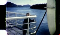
- Item consists of one silent colour film segment providing glimpses of the McLean children playing with a puppy in their yard at 4378 Halley Avenue South in Burnaby, a trip on a British Columbia Ferry, a zoo (poor quality), and sports day with a 3 legged race, potato sack races and square dancing (p…
- Repository
- City of Burnaby Archives
- Date
- 1962
- Collection/Fonds
- George H.F. McLean fonds
- Physical Description
- 1 digital file ( 4 min., 15 sec ) : digital , col., si.
- Description Level
- Item
- Record No.
- 567-001-2
- Access Restriction
- No restrictions
- Reproduction Restriction
- May be restricted by third party rights
- Accession Number
- 2014-03
- Scope and Content
- Item consists of one silent colour film segment providing glimpses of the McLean children playing with a puppy in their yard at 4378 Halley Avenue South in Burnaby, a trip on a British Columbia Ferry, a zoo (poor quality), and sports day with a 3 legged race, potato sack races and square dancing (possibly located at Central Park in Burnaby).
- Media Type
- Moving Images
- Photographer
- McLean, George H.F.
- Notes
- Title based on content of film
- Films originated in an 8mm format and were digitized by George McLean before being donated to the CBA
- Street Address
- 4378 Halley Avenue
- Historic Neighbourhood
- Broadview (Historic Neighbourhood)
- Planning Study Area
- Cascade-Schou Area
Images

Video
McLean children at play, 1962
McLean children at play, 1962
https://search.heritageburnaby.ca/media/hpo/_Data/_Archives_Moving_Images/_Unrestricted/567-001-2.m4vRonald G. Scobbie collection
https://search.heritageburnaby.ca/link/museumdescription11914
- Repository
- Burnaby Village Museum
- Date
- [1890]-1932
- Collection/Fonds
- Ronald G. Scobbie collection
- Description Level
- Fonds
- Physical Description
- 55 plans + 2 architectural drawings + 1 map + graphic materials + 3 cm of textual records
- Scope and Content
- Fonds consists of survey and subdivision plans, a map and records created by Provincial Land Surveyors Albert J. Hill and Geoffrey K. Burnett and Donald Johnson McGugan and collected by Ronald G. Scobbie. Records include subdivision and survey plans in New Westminster District Group 1 including Dis…
- Repository
- Burnaby Village Museum
- Collection/Fonds
- Ronald G. Scobbie collection
- Description Level
- Fonds
- Physical Description
- 55 plans + 2 architectural drawings + 1 map + graphic materials + 3 cm of textual records
- Scope and Content
- Fonds consists of survey and subdivision plans, a map and records created by Provincial Land Surveyors Albert J. Hill and Geoffrey K. Burnett and Donald Johnson McGugan and collected by Ronald G. Scobbie. Records include subdivision and survey plans in New Westminster District Group 1 including District Lots in Burnaby along with various school sites and church plans; surveying records regarding North Road and a map of the Burnaby Municipality. Fonds is arranged into series: 1) Subdivision and survey plans series 2) School and church plans series 3) Map series
- History
- Ronald G. Scobbie was born in Scotland. After graduating from high school, he worked in the mines of Scotland which led to a career as a land surveyor. Ron immigrated to Canada in 1965 and settled in North Vancouver. In 1967 he became a partner in the surveying company of Hunter, Crockford & Scobbie in New Westminster, eventually owning it under the title Scobbie and Associates between 1980 and 1995. Ron sold the business in 1995 and retired as a BC Land Surveyor in December 2003. Ron was an active member of the B.C. Land Surveyors Association and an avid collector of surveying equipment and maps and plans that document the history of surveying in British Columbia. Upon retirement, Ron donated many historical maps and plans to various repositories located in different geographical regions throughout B.C.
- Scobbie & Associates land surveying company dates back to 1890 when Albert J. Hill first established his practice as a land surveyor in New Westminster. The company went through a series of Surveyors (owners) between 1890 and 1995:
- Albert James Hill (A.J. Hill) [1890] to 1912
- Hill & Burnett 1911 to 1912
- Geoffrey K. Burnett 1912
- Burnett & McGugan 1912 to 1947
- Burnett, McGugan & Hunter 1947 to 1959
- Burnett, Hunter & Douglas 1959 to 1960
- Hunter, Douglas & Crockford 1960 to 1964
- Hunter, Crockford & Associates 1964 to 1965
- Hunter, Crockford & Aplin 1965 to 1967
- Hunter, Crockford & Scobbie 1967 to 1973
- Crockford, Scobbie & Associates 1973-1980
- Scobbie & Associates 1980 to 1995
- Responsibility
- Scobbie, Ronald G.
- Accession Code
- HV984.57
- BV003.83
- Access Restriction
- No restrictions
- Reproduction Restriction
- No known restrictions
- Date
- [1890]-1932
- Related Material
- For other survey and subdivision plans created by land surveyors Albert J. Hill, Geoffery K. Burnett and Donald J. McGugan, see: Burnaby Village Museum Map collection - Survey and Subdivision plans series
- Notes
- Title based on contents of collection
Way Sang Yuen Wat Kee & Co.
https://search.heritageburnaby.ca/link/museumdescription4648
- Repository
- Burnaby Village Museum
- Date
- 1908-1975
- Collection/Fonds
- Way Sang Yuen Wat Kee & Co. fonds
- Description Level
- Fonds
- Physical Description
- 3 folders of textual records + 180 photographs + ephemera + 1 map + 1 architectural drawing
- Scope and Content
- Fonds consists of records acquired from the Chinese Herbalist shop “Way Sang Yuen Wat Kee & Co” operating in Victoria from 1905 until 1968. Textual records include a few pieces of correspondence, receipts and ephemera addressed to "Way Sang Yuen Wat Kee & Co.", Lim You and Lim Yau (Yew Long Lum) wh…
- Repository
- Burnaby Village Museum
- Collection/Fonds
- Way Sang Yuen Wat Kee & Co. fonds
- Description Level
- Fonds
- Physical Description
- 3 folders of textual records + 180 photographs + ephemera + 1 map + 1 architectural drawing
- Scope and Content
- Fonds consists of records acquired from the Chinese Herbalist shop “Way Sang Yuen Wat Kee & Co” operating in Victoria from 1905 until 1968. Textual records include a few pieces of correspondence, receipts and ephemera addressed to "Way Sang Yuen Wat Kee & Co.", Lim You and Lim Yau (Yew Long Lum) while the shop was in operation at 1620 Government Street in the 1940s. Some of the records are written in English while a portion are written in Cantonese and haven't been translated. Most of the photographs document the content of the original shop at the time of aquistion in 1975. Some photographs of unidentified people may be related to the owner or proprietor of the shop. A collection of other photographs document various Chinese Canadian organizations that were in operation in Victoria. Records are arranged into the following series: 1) Way Sang Yuen Wat Kee & Co. photographs series 2) Way Sang Yuen Wat Kee & Co. documents series
- History
- The Chinese Herbalist shop "Way Sang Yuen Wat Kee & Co" operated in Victoria, BC from about 1905 until [1968]. The meaning of "Way Sang Yuen Wat Kee & Co" can be translated as "Collection, Life, Source, Alive, Shop" although many interpretations can be taken since each Chinese character can have several meanings. Contents of the shop were purchased by the Burnaby Village Museum in 1975 and reassembled as a permanent display in the Burnaby Village Museum. The shop’s original owner was Ng Chee Fong who opened the shop ca.1905. In 1921, Ng returned to Hong Kong and sold the business to Lam Yuen and Wong Ying who were from Vancouver. Lam Yuen and Wong Ying employed Lum Chuck Yue to operate the shop. Lum Chuck Yue had formerly operated a small herbal counter in a Chinese apothecary store on the south side of Fisgard Street, Victoria. In 1924 Lam Yuen and Wong Ying purchased Wah Sun & Co. from Lee S. Yew and Way Sang Yuen Wat Kee & Co. moved into the Wah Sun premises at 1620 Government Street in the Lee Block . The furnishings and fixtures of both stores were combined, with the more elaborate fixtures from WSYWK remaining as part of the public part of the shop and the plainer fixtures of Wah Sun moved into the workroom and basement. In the 1930s Lum Chuck Yue took over the business and became the proprietor. In about 1934, Tan Yi Tang purchased the business and the shop reopened as Way Sang Yuen Wat Kee & Co. following renovations with Lum Yew Jong as the shop's proprietor. Lum Yew Jong continued to operate the shop until his death in 1967 at the age of 68 years. Following Lum’s death, the property and contents of the shop were purchased by Mr. J. Watson Marles, a local owner operator of an antique store at 1714 Government Street. The shop and contents went through a few more private owners including Rodney Pain before it was purchased by the Heritage Village Museum in 1975 with funds made available by the Vancouver Foundation and the Province of British Columbia. Contents of the original shop were reasembled in a reconstructed building as a permanent display on site at the Burnaby Village Museum.
- Creator
- Way Sang Yuen Wat Kee & Company
- Accession Code
- HV975.5
- BV985.5331
- BV017.7
- Access Restriction
- Restricted access
- Reproduction Restriction
- May be restricted by third party rights
- Date
- 1908-1975
- Related Material
- See also Artifacts under Accessions HV975.5; BV985.5331 and BV017.7
- Notes
- Title based on contents of fonds