Narrow Results By
Subject
- Advertising Medium - Signs and Signboards 3
- Aerial Photographs 3
- Animals - Dogs 1
- Animals - Horses 1
- Buildings - Civic - Hospitals 5
- Buildings - Commercial - Drive-in Theatres 12
- Buildings - Industrial 1
- Buildings - Industrial - Factories 4
- Buildings - Religious - Churches 2
- Celebrations - Birthdays 5
- Celebrations - New Years Eve 1
- Clothing - Uniforms 2
Creator
- Associated Factory Mutual Fire Insurance Cos 1
- British Columbia Government Photograph 1
- Cunningham, W. 2
- Empire Photo Service 1
- Garden, Hermon and Burwell 1
- George Allen Aerial Photos Limited 1
- Graphic Industries Limited 2
- Henry Tregillas Photography Ltd. 1
- King, Basil 1
- Lindsay, Jack 1
- McLean, George H.F. 14
- Schwabb, C.L. Jr. 1
![Snow at Lougheed Drive-In Theatre, [1964] (date of original), copied 1991 thumbnail](/media/hpo/_Data/_Archives_Images/_Unrestricted/370/370-478.jpg?width=280)
Snow at Lougheed Drive-In Theatre
https://search.heritageburnaby.ca/link/archivedescription37890
- Repository
- City of Burnaby Archives
- Date
- [1964] (date of original), copied 1991
- Collection/Fonds
- Burnaby Historical Society fonds
- Description Level
- Item
- Physical Description
- 1 photograph : b&w ; 3.0 x 3.0 cm print on contact sheet 20.4 x 26.9 cm
- Scope and Content
- Photograph of the Lougheed Drive-In Theatre on the 4200 block of Lougheed Highway at Gilmore Avenue, in the snow.
- Repository
- City of Burnaby Archives
- Date
- [1964] (date of original), copied 1991
- Collection/Fonds
- Burnaby Historical Society fonds
- Subseries
- Burnaby Image Bank subseries
- Physical Description
- 1 photograph : b&w ; 3.0 x 3.0 cm print on contact sheet 20.4 x 26.9 cm
- Description Level
- Item
- Record No.
- 370-478
- Access Restriction
- No restrictions
- Reproduction Restriction
- No restrictions
- Accession Number
- BHS1999-03
- Scope and Content
- Photograph of the Lougheed Drive-In Theatre on the 4200 block of Lougheed Highway at Gilmore Avenue, in the snow.
- Media Type
- Photograph
- Notes
- Title based on contents of photograph
- 1 b&w copy negative accompanying
- Negative has a pink cast
- Copied from col. photograph
- Geographic Access
- Lougheed Highway
- Historic Neighbourhood
- Broadview (Historic Neighbourhood)
- Planning Study Area
- West Central Valley Area
Images
![Snow at Lougheed Drive-In Theatre, [1964] (date of original), copied 1991 thumbnail](/media/hpo/_Data/_Archives_Images/_Unrestricted/370/370-478.jpg)
![Snow at Lougheed Drive-In Theatre, [1964] (date of original), copied 1991 thumbnail](/media/hpo/_Data/_Archives_Images/_Unrestricted/370/370-479.jpg?width=280)
Snow at Lougheed Drive-In Theatre
https://search.heritageburnaby.ca/link/archivedescription37891
- Repository
- City of Burnaby Archives
- Date
- [1964] (date of original), copied 1991
- Collection/Fonds
- Burnaby Historical Society fonds
- Description Level
- Item
- Physical Description
- 1 photograph : b&w ; 3.0 x 3.0 cm print on contact sheet 20.4 x 26.9 cm
- Scope and Content
- Photograph of the Lougheed Drive-In Theatre on the 4200 block of Lougheed Highway at Gilmore Avenue, in the snow.
- Repository
- City of Burnaby Archives
- Date
- [1964] (date of original), copied 1991
- Collection/Fonds
- Burnaby Historical Society fonds
- Subseries
- Burnaby Image Bank subseries
- Physical Description
- 1 photograph : b&w ; 3.0 x 3.0 cm print on contact sheet 20.4 x 26.9 cm
- Description Level
- Item
- Record No.
- 370-479
- Access Restriction
- No restrictions
- Reproduction Restriction
- No restrictions
- Accession Number
- BHS1999-03
- Scope and Content
- Photograph of the Lougheed Drive-In Theatre on the 4200 block of Lougheed Highway at Gilmore Avenue, in the snow.
- Media Type
- Photograph
- Notes
- Title based on contents of photograph
- 1 b&w copy negative accompanying
- Negative has a pink cast
- Copied from col. photograph
- Geographic Access
- Lougheed Highway
- Historic Neighbourhood
- Broadview (Historic Neighbourhood)
- Planning Study Area
- West Central Valley Area
Images
![Snow at Lougheed Drive-In Theatre, [1964] (date of original), copied 1991 thumbnail](/media/hpo/_Data/_Archives_Images/_Unrestricted/370/370-479.jpg)
![Subdivision plans in New Westminster District Group 1 – Burnaby
, [1890-1910] thumbnail](/media/hpo/_Data/_BVM_Cartographic_Material/1977/1977_0093_0014a_001.jpg?width=280)
Subdivision plans in New Westminster District Group 1 – Burnaby
https://search.heritageburnaby.ca/link/museumdescription6983
- Repository
- Burnaby Village Museum
- Date
- [1890-1910]
- Collection/Fonds
- Burnaby Village Museum Map collection
- Description Level
- File
- Physical Description
- 4 plans : blueprint ink on paper mounted on 2 sides of cardboard 76 x 102 cm
- Scope and Content
- Item consists of a large board of two New Westminster District Gp 1 - subdivision plans mounted on one side and two New Westminster District Gp 1 - subdivision plans mounted on the other side. Side A: 1. Blueprint "Plan of / Subdivision of Lot No. 69 / Group One / New Westminster District / Pro…
- Repository
- Burnaby Village Museum
- Collection/Fonds
- Burnaby Village Museum Map collection
- Description Level
- File
- Physical Description
- 4 plans : blueprint ink on paper mounted on 2 sides of cardboard 76 x 102 cm
- Material Details
- Scales [between 1:1584 and 1:3168]
- Index number on edge of board reads: "14"
- Scope and Content
- Item consists of a large board of two New Westminster District Gp 1 - subdivision plans mounted on one side and two New Westminster District Gp 1 - subdivision plans mounted on the other side. Side A: 1. Blueprint "Plan of / Subdivision of Lot No. 69 / Group One / New Westminster District / Property of Ernest Buse, Esq. / Scale 3 chs = 1 in. / Map No 290". Plan is signed by "Garden, Hermon and Burwell, Dom. Land Surveyor" (Geographic location: Burnaby) 2. Blueprint "Plan / of Subdivision / of Lots 1-19, 36-53 and 69-75 inclusive / in the Subdivision / of / Lot 30 / Group One / New Westminster District / Scale 2 chs = 1 in. Map No 631". Plan is signed by "Jno [sic] Strathern [sic] P.L.S." Names and Lot numbers are handwritten in red pencil in sections along Douglas Road and read: "20 - F / 21 - Fitherstruhaul [sic] / 22 - J.S. Craig / 23 - McGill & Dill / 24 / 25 / 26 / 27 / 28 - School / 29 - School / 30 - D. McDownall / 31 - W.J. Troloow [sic] / 32 - N.C. Nelson / 33 - _[sic] McGill / 34 - T.S.[sic] Craig / 35" (Geographic location: Burnaby) Side B: 1.Blueprint "Plan / of Subdivision / of Centre Portion / of Lot 28 / Group One / New Westminster District / Scale 200' = 1" / Map No 627". Plan is signed by "Jno Strathern / P.L.S." (Geographic location: Burnaby) 2. Blueprint "Plan / of Subdivision / of N.1/2 Lot 100 and S.1/2 Lot 101, / Group One / New Westminster District, BC / Scale 4 chs = 1 in." (Geographic location: Burnaby)
- Names
- Strathern, John
- Accession Code
- HV977.93.14
- Access Restriction
- No restrictions
- Reproduction Restriction
- No known restrictions
- Date
- [1890-1910]
- Media Type
- Cartographic Material
- Historic Neighbourhood
- Broadview (Historic Neighbourhood)
- East Burnaby (Historic Neighbourhood)
- Planning Study Area
- Cascade-Schou Area
- West Central Valley Area
- Second Street Area
- Lake City Area
- Scan Resolution
- 300
- Scale
- 72
- Notes
- Title based on contents of file
- Scale is measured in chains and feet. (One chain equals 792 inches)
- The term "Lot" can also refer to a "District Lot”
Images
![Subdivision plans in New Westminster District Group 1 – Burnaby
, [1890-1910] thumbnail](/media/hpo/_Data/_BVM_Cartographic_Material/1977/1977_0093_0014a_001.jpg)

![Tom White, Dave Maw, and Bert Vicars, [1956] thumbnail](/media/hpo/_Data/_BVM_Images/2000/200300460012.jpg?width=280)
Tom White, Dave Maw, and Bert Vicars
https://search.heritageburnaby.ca/link/museumdescription1745
- Repository
- Burnaby Village Museum
- Date
- [1956]
- Collection/Fonds
- Burnaby Village Museum Photograph collection
- Description Level
- Item
- Physical Description
- 1 photograph : b&w ; 7.5 x 7.5 cm
- Scope and Content
- Photograph of Tom White, Dave Maw, and Bert Vicars, three Dominion Bridge Company staff, standing in front of a car that has been parked in front of Dominion Bridge Company's Burnaby Plant.
- Repository
- Burnaby Village Museum
- Collection/Fonds
- Burnaby Village Museum Photograph collection
- Description Level
- Item
- Physical Description
- 1 photograph : b&w ; 7.5 x 7.5 cm
- Material Details
- Photograph has scalloped edges
- Scope and Content
- Photograph of Tom White, Dave Maw, and Bert Vicars, three Dominion Bridge Company staff, standing in front of a car that has been parked in front of Dominion Bridge Company's Burnaby Plant.
- Subjects
- Industries - Construction
- Geographic Access
- Henning Drive
- Street Address
- 3880 Henning Drive
- Accession Code
- BV003.46.12
- Access Restriction
- No restrictions
- Reproduction Restriction
- No known restrictions
- Date
- [1956]
- Media Type
- Photograph
- Historic Neighbourhood
- Broadview (Historic Neighbourhood)
- Planning Study Area
- West Central Valley Area
- Scan Resolution
- 600
- Scan Date
- 09-Jun-09
- Scale
- 100
- Notes
- Title based on contents of photograph
- Note in black ink on verso of photograph reads: "Tom White / Dave Maw / Bert Vicars"
Images
![Tom White, Dave Maw, and Bert Vicars, [1956] thumbnail](/media/hpo/_Data/_BVM_Images/2000/200300460012.jpg)
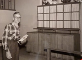
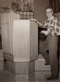
William Myers at St Andrews altar
https://search.heritageburnaby.ca/link/archivedescription88373
- Repository
- City of Burnaby Archives
- Date
- 1961 (date of original)
- Collection/Fonds
- Elaine A. Myers fonds
- Description Level
- Item
- Physical Description
- 1 photograph (jpeg) : sepia ; 96 dpi
- Scope and Content
- Photograph of Elaine's father, William Myers next to the the altar of St. Andrews Church that he built.
- Repository
- City of Burnaby Archives
- Date
- 1961 (date of original)
- Collection/Fonds
- Elaine A. Myers fonds
- Physical Description
- 1 photograph (jpeg) : sepia ; 96 dpi
- Material Details
- Jpeg is a copy created by the donor of a sepia original
- Description Level
- Item
- Record No.
- 580-003
- Access Restriction
- No restrictions
- Reproduction Restriction
- No restrictions
- Accession Number
- 2013-26
- Scope and Content
- Photograph of Elaine's father, William Myers next to the the altar of St. Andrews Church that he built.
- Subjects
- Buildings - Religious - Churches
- Media Type
- Photograph
- Notes
- Title based on contents of photograph
- Geographic Access
- Norfolk Street
- Gilmore Avenue
- Historic Neighbourhood
- Broadview (Historic Neighbourhood)
- Planning Study Area
- Cascade-Schou Area
Images
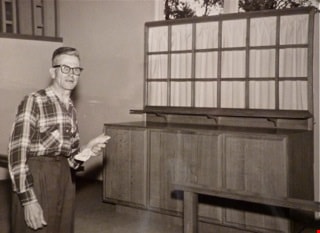

William Myers at St. Andrews pulpit
https://search.heritageburnaby.ca/link/archivedescription88374
- Repository
- City of Burnaby Archives
- Date
- 1961 (date of original)
- Collection/Fonds
- Elaine A. Myers fonds
- Description Level
- Item
- Physical Description
- 1 photograph (jpeg) : sepia ; 96 dpi
- Scope and Content
- Photograph of Elaine's father, William Myers next to the pulpit of St. Andrews Church that he built.
- Repository
- City of Burnaby Archives
- Date
- 1961 (date of original)
- Collection/Fonds
- Elaine A. Myers fonds
- Physical Description
- 1 photograph (jpeg) : sepia ; 96 dpi
- Material Details
- Jpeg is a copy created by the donor of a sepia original
- Description Level
- Item
- Record No.
- 580-004
- Access Restriction
- No restrictions
- Reproduction Restriction
- No restrictions
- Accession Number
- 2013-26
- Scope and Content
- Photograph of Elaine's father, William Myers next to the pulpit of St. Andrews Church that he built.
- Subjects
- Buildings - Religious - Churches
- Media Type
- Photograph
- Notes
- Title based on contents of photograph
- Geographic Access
- Norfolk Street
- Gilmore Avenue
- Historic Neighbourhood
- Broadview (Historic Neighbourhood)
- Planning Study Area
- Cascade-Schou Area
Images
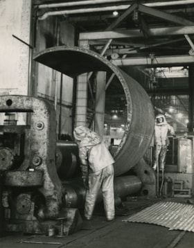
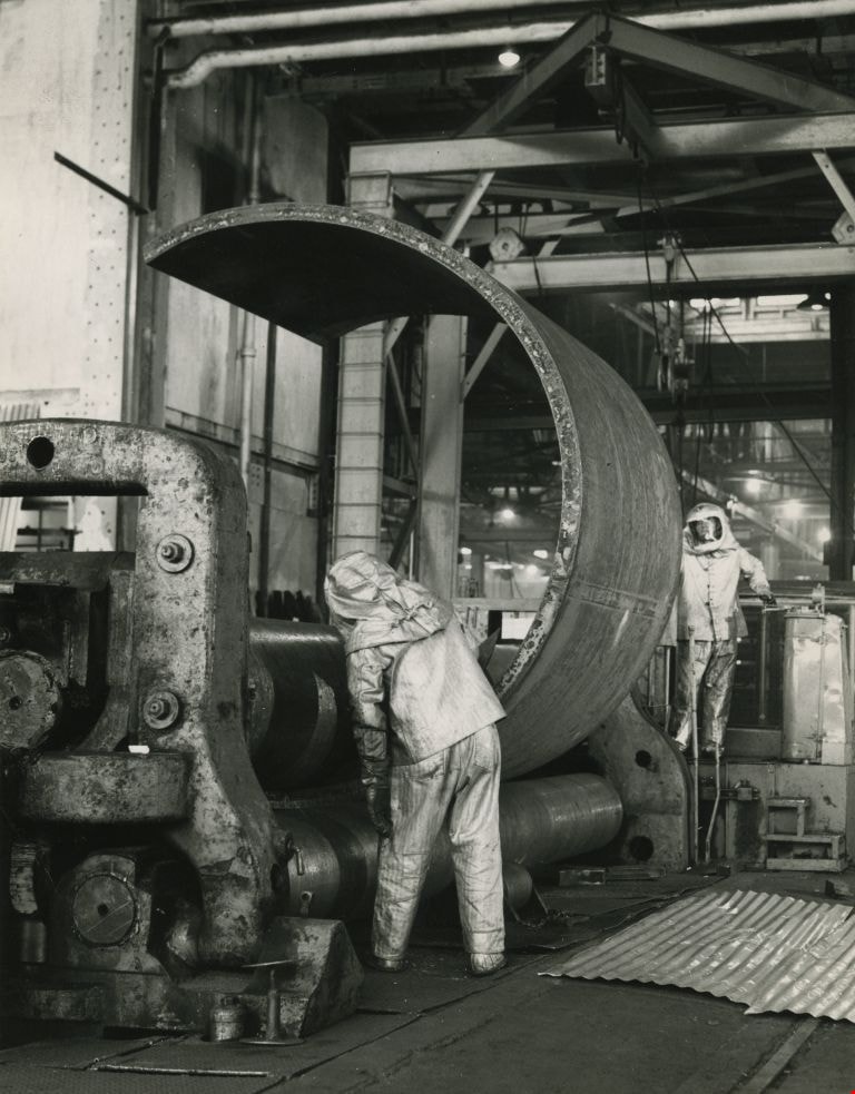
Working at the Dominion Bridge Co.'s Burnaby plant
https://search.heritageburnaby.ca/link/archivedescription45613
- Repository
- City of Burnaby Archives
- Date
- April 1966, published April 18, 1966
- Collection/Fonds
- Columbian Newspaper collection
- Description Level
- Item
- Physical Description
- 1 photograph : b&w ; 24 x 18.5 cm
- Scope and Content
- Photograph of workmen at the Dominion Bridge Co.'s Burnaby plant. They are feeding a flat steel plate, more than three inches think inot a pyramind roll for fabrication in the making of a sulfinol vessel for the petroleum industry in Alberta. The workmen are wearing asbestos aluminum suits to withs…
- Repository
- City of Burnaby Archives
- Date
- April 1966, published April 18, 1966
- Collection/Fonds
- Columbian Newspaper collection
- Physical Description
- 1 photograph : b&w ; 24 x 18.5 cm
- Description Level
- Item
- Record No.
- 480-507
- Access Restriction
- No restrictions
- Reproduction Restriction
- Reproduce for fair dealing purposes only
- Accession Number
- 2003-02
- Scope and Content
- Photograph of workmen at the Dominion Bridge Co.'s Burnaby plant. They are feeding a flat steel plate, more than three inches think inot a pyramind roll for fabrication in the making of a sulfinol vessel for the petroleum industry in Alberta. The workmen are wearing asbestos aluminum suits to withstand the intense heat reflected from the heated plate (the plate was heated in a furnace before being fed into the pyramid roll).
- Names
- Dominion Bridge Company
- Media Type
- Photograph
- Photographer
- Henry Tregillas Photography Ltd.
- Notes
- Title based on contents of photograph
- Geographic Access
- Boundary Road
- Street Address
- 2400 Boundary Road
- Historic Neighbourhood
- Broadview (Historic Neighbourhood)
- Planning Study Area
- West Central Valley Area
Images
![Yellowstone National Park and Birthday Party, [Between 1963 - 1970] thumbnail](/media/Hpo/_Data/_Archives_Moving_Images/_Unrestricted/567-001-8.jpg?width=280)
Yellowstone National Park and Birthday Party
https://search.heritageburnaby.ca/link/archivedescription85423
- Repository
- City of Burnaby Archives
- Date
- [Between 1963 - 1970]
- Collection/Fonds
- George H.F. McLean fonds
- Description Level
- Item
- Physical Description
- 1 digital file ( 4 min., 19 sec ) : digital , col., si.
- Scope and Content
- Item consists of one silent colour film and opens with footage of the McLean family visiting the Old Faithfull Geyser at Yellowstone National Park and switches to Teresa McLean and friend with hula skirts dancing in a backyard, followed by footage of young girls playing games at Teresa's eighth bir…
- Repository
- City of Burnaby Archives
- Date
- [Between 1963 - 1970]
- Collection/Fonds
- George H.F. McLean fonds
- Physical Description
- 1 digital file ( 4 min., 19 sec ) : digital , col., si.
- Description Level
- Item
- Record No.
- 567-001-8
- Access Restriction
- No restrictions
- Reproduction Restriction
- May be restricted by third party rights
- Accession Number
- 2014-03
- Scope and Content
- Item consists of one silent colour film and opens with footage of the McLean family visiting the Old Faithfull Geyser at Yellowstone National Park and switches to Teresa McLean and friend with hula skirts dancing in a backyard, followed by footage of young girls playing games at Teresa's eighth birthday party at the McLean family home on Halley Avenue.
- Names
- McLean, Teresa
- Media Type
- Moving Images
- Photographer
- McLean, George H.F.
- Notes
- Title based on content of film
- Films originated in an 8mm format and were digitized by George McLean before being donated to the CBA
- Street Address
- 4378 Halley Avenue
- Historic Neighbourhood
- Broadview (Historic Neighbourhood)
- Planning Study Area
- Cascade-Schou Area
Images
![Yellowstone National Park and Birthday Party, [Between 1963 - 1970] thumbnail](/media/Hpo/_Data/_Archives_Moving_Images/_Unrestricted/567-001-8.jpg)
Video
Yellowstone National Park and Birthday Party, [Between 1963 - 1970]
Yellowstone National Park and Birthday Party, [Between 1963 - 1970]
https://search.heritageburnaby.ca/media/hpo/_Data/_Archives_Moving_Images/_Unrestricted/567-001-8.m4v