Narrow Results By
Subject
- Advertising Medium - Signs and Signboards 1
- Animals - Birds 2
- Animals - Cows 1
- Buildings - Agricultural - Greenhouses 1
- Buildings - Civic - Hospitals 2
- Buildings - Commercial 1
- Buildings - Heritage 58
- Buildings - Recreational - Outdoor Swimming Pools 1
- Buildings - Residential - Apartments 1
- Buildings - Residential - Houses 4
- Buildings - Residential - Seniors Housing 1
- Buildings - Schools 1
Person / Organization
- Barnes, Hannah Victoria "Girlie" Love 1
- Beaton, N. 1
- Bolton, Richard 1
- Bowes, M. 1
- Brandrith, Martha Dorothy “Dot” Love 1
- British Columbia Electric Railway Company 1
- Brown, Charles B. "Charlie" 1
- Brown, Clifton Gilbert, 1889-1960 1
- Burnaby Historical Society 2
- Butler, Edwin 1
- Butler, Gladys 1
- Butler, Margaret 1

Cariboo-Armstrong Neighbourhood
https://search.heritageburnaby.ca/link/landmark825
- Repository
- Burnaby Heritage Planning
- Associated Dates
- 1955-2008
- Heritage Value
- The Cariboo-Armstrong Neighbourhood was mainly subdivided in the 1950s during the major building boom in Burnaby throughout the post-war years. Considered a primarily residential area, the neighbourhood has quick and convenient access to major highways and roads as well as being bordered to the north by the George Derby Conservation area.
- Historic Neighbourhood
- East Burnaby (Historic Neighbourhood)
- Planning Study Area
- Cariboo-Armstrong Area
Images


Charles R. Shaw House
https://search.heritageburnaby.ca/link/landmark525
- Repository
- Burnaby Heritage Planning
- Description
- The Charles R. Shaw House is a one and one-half storey plus basement wood-frame late Victorian era residence, located on the grounds of the Normanna Rest Home development in East Burnaby, near its original location on this site. Originally a modest vernacular Victorian structure, it has been enlarg…
- Associated Dates
- 1891
- Formal Recognition
- Heritage Designation, Community Heritage Register
- Other Names
- Charles R. & Mary Shaw House
- Street View URL
- Google Maps Street View
- Repository
- Burnaby Heritage Planning
- Other Names
- Charles R. & Mary Shaw House
- Geographic Access
- 12th Avenue
- 4th Street
- 13th Avenue
- Associated Dates
- 1891
- Formal Recognition
- Heritage Designation, Community Heritage Register
- Enactment Type
- Bylaw No. 10739
- Enactment Date
- 06/04/1998
- Description
- The Charles R. Shaw House is a one and one-half storey plus basement wood-frame late Victorian era residence, located on the grounds of the Normanna Rest Home development in East Burnaby, near its original location on this site. Originally a modest vernacular Victorian structure, it has been enlarged and embellished through later additions.
- Heritage Value
- The Shaw House is one of the oldest surviving houses in Burnaby, and is valued as a representation of a typical vernacular pioneer house in Burnaby, and a rare survivor from the late Victorian era. The original portion of the house displays a simplicity of form and detail consistent with early local construction, while the later additions display a more sophisticated approach. Originally built in 1891, this house is valued for its association with first owner, Charles R. Shaw (1834-1916) and Mary D. Shaw (1848-1897), one of Burnaby’s earliest settlers. Born in England, Shaw immigrated to Toronto in 1869, and relocated to New Westminster in 1889, where he worked as an employee of the Mechanic's Mill Company, an early woodworking plant. After moving to Burnaby, he was unanimously elected by acclamation as first reeve (mayor) of the new municipality in 1892. In 1894, Shaw sold his house and farm and moved his family to Kamloops due to his wife Mary's failing health. After Mary died in 1897, the Shaw family returned to Toronto. The Shaw House is additionally valued for its association with a later owner, James Brookes (1884-1953), founder of James Brookes Woodworking Ltd., a mill that was a major employer in East Burnaby. Brookes bought and renovated the house in 1917. In 1927, he built a much larger house on the property (now demolished), and the original house was moved to the corner of the property to serve as a gardener's cottage for Brookes' estate. The additions made to the house at this time employed sash and milled products produced by the Brookes plant. Although altered, this Victorian era residence remains largely intact, with Brookes’s later additions.
- Defining Elements
- Key elements that define the heritage character of the Shaw House include its: - modest vernacular residential form, scale and massing, as exemplified by its one and one-half storey plus basement height, front gabled roof, shed roofed verandah and asymmetrical plan - asymmetrical front entrance - cladding: horizontal wooden drop siding on the original portion of the house; cedar shingles on additions; decorative octagonal cedar shingles in the front gable; original decorated bargeboards at front, with cut-out details - later renovations to the front verandah and side addition which resulted in a partially glazed porch entrance and addition with large window assemblies - square verandah columns - irregular fenestration: double-hung wooden-sash windows in a variety of configurations such as 6-over-1 and 4-over-1 windows in the original portion of the house, 12-over-1 windows, and one 24-over-1 window in the front addition - small window at front entry - fifteen-pane French front entry door - internal red brick chimney with corbelled cap
- Historic Neighbourhood
- East Burnaby (Historic Neighbourhood)
- Planning Study Area
- Edmonds Area
- Function
- Primary Historic--Single Dwelling
- Primary Current--Single Dwelling
- Community
- Burnaby
- Cadastral Identifier
- 003-253-848
- Boundaries
- The Shaw House is comprised of a single residential lot located at 7725 Fourth Street (legal address), Burnaby
- Area
- 9199.27
- Contributing Resource
- Building
- Ownership
- Private
- Names
- Shaw, Charles R
- Street Address
- 7725 4th Street
- Street View URL
- Google Maps Street View
Images


Second Street Neighbourhood
https://search.heritageburnaby.ca/link/landmark826
- Repository
- Burnaby Heritage Planning
- Associated Dates
- 1955-2008
- Heritage Value
- Second Street had its origins in the 1910-1920 era and the Second Street Elementary School was built in 1928. Substantial new housing was built in the late 1940s and 1950s and infilling occurred during the 1960s and 1970s. By the 1980s, the neighbourhood was primarily a single family area with a small number of multi-family buildings.
- Historic Neighbourhood
- East Burnaby (Historic Neighbourhood)
- Planning Study Area
- Second Street Area
Images


6742 Walker Avenue
https://search.heritageburnaby.ca/link/archivedescription37864
- Repository
- City of Burnaby Archives
- Date
- 1990 (date of original), copied 1991
- Collection/Fonds
- Burnaby Historical Society fonds
- Description Level
- Item
- Physical Description
- 1 photograph : b&w ; 3.2 x 4.8 cm print on contact sheet 20.4 x 26.7 cm
- Scope and Content
- Photograph of 6742 Walker Avenue, taken in the summer of 1990.
- Repository
- City of Burnaby Archives
- Date
- 1990 (date of original), copied 1991
- Collection/Fonds
- Burnaby Historical Society fonds
- Subseries
- Burnaby Image Bank subseries
- Physical Description
- 1 photograph : b&w ; 3.2 x 4.8 cm print on contact sheet 20.4 x 26.7 cm
- Description Level
- Item
- Record No.
- 370-452
- Access Restriction
- No restrictions
- Reproduction Restriction
- No restrictions
- Accession Number
- BHS1999-03
- Scope and Content
- Photograph of 6742 Walker Avenue, taken in the summer of 1990.
- Subjects
- Buildings - Residential - Houses
- Media Type
- Photograph
- Notes
- Title based on contents of photograph
- 1 b&w copy negative accompanying
- Negative has a pink cast
- Copied from col. photograph
- Geographic Access
- Walker Avenue
- Street Address
- 6742 Walker Avenue
- Historic Neighbourhood
- East Burnaby (Historic Neighbourhood)
- Planning Study Area
- Richmond Park Area
Images

7465 Mulberry Place
https://search.heritageburnaby.ca/link/archivedescription94305
- Repository
- City of Burnaby Archives
- Date
- February 1994
- Collection/Fonds
- Grover, Elliott & Co. Ltd. fonds
- Description Level
- File
- Physical Description
- 22 photographs : col. negatives ; 35 mm
- Scope and Content
- Photographs of an undeveloped, forested property located at 7465 Mulberry Place.
- Repository
- City of Burnaby Archives
- Date
- February 1994
- Collection/Fonds
- Grover, Elliott & Co. Ltd. fonds
- Physical Description
- 22 photographs : col. negatives ; 35 mm
- Description Level
- File
- Record No.
- 622-090
- Access Restriction
- No restrictions
- Reproduction Restriction
- No restrictions
- Accession Number
- 2017-39
- Scope and Content
- Photographs of an undeveloped, forested property located at 7465 Mulberry Place.
- Subjects
- Geographic Features - Forests
- Media Type
- Photograph
- Notes
- Transcribed title
- Title transcribed from envelope photographs were originally housed in
- File no. 94-051-B
- Photographer identified as "J.C."
- Geographic Access
- Mulberry Place
- Street Address
- 7465 Mulberry Place
- Historic Neighbourhood
- East Burnaby (Historic Neighbourhood)
- Planning Study Area
- Cariboo-Armstrong Area
7818 6th Street
https://search.heritageburnaby.ca/link/archivedescription93731
- Repository
- City of Burnaby Archives
- Date
- 1989
- Collection/Fonds
- Grover, Elliott & Co. Ltd. fonds
- Description Level
- File
- Physical Description
- 26 photographs : col. negatives ; 35 mm
- Scope and Content
- Photographs of the exterior of a Benjamin Moore Paints store and surrounding area. The store is located on a corner opposite Microtel and outside the store, a sign for the Skytrain Operations and Maintenance Centre is visible.
- Repository
- City of Burnaby Archives
- Date
- 1989
- Collection/Fonds
- Grover, Elliott & Co. Ltd. fonds
- Physical Description
- 26 photographs : col. negatives ; 35 mm
- Description Level
- File
- Record No.
- 622-019
- Access Restriction
- No restrictions
- Reproduction Restriction
- No restrictions
- Accession Number
- 2017-39
- Scope and Content
- Photographs of the exterior of a Benjamin Moore Paints store and surrounding area. The store is located on a corner opposite Microtel and outside the store, a sign for the Skytrain Operations and Maintenance Centre is visible.
- Media Type
- Photograph
- Notes
- Transcribed title
- Title transcribed from original print envelope
- File no. 89v-004-O
- Property address could not be confirmed at time of description.
- Geographic Access
- 6th Street
- 12th Avenue
- Street Address
- 7818 6th Street
- Historic Neighbourhood
- East Burnaby (Historic Neighbourhood)
- Planning Study Area
- Second Street Area
8357 Tenth Avenue, 8350 and 8353 Eleventh Avenue
https://search.heritageburnaby.ca/link/archivedescription93724
- Repository
- City of Burnaby Archives
- Date
- 1989
- Collection/Fonds
- Grover, Elliott & Co. Ltd. fonds
- Description Level
- File
- Physical Description
- 24 photographs : col. negatives ; 35 mm
- Scope and Content
- Photographs of the exterior of the low-rise apartment complex located at 8357 10th Avenue and 8350 and 8353 11th Avenue and the laneway running between the buildings.
- Repository
- City of Burnaby Archives
- Date
- 1989
- Collection/Fonds
- Grover, Elliott & Co. Ltd. fonds
- Physical Description
- 24 photographs : col. negatives ; 35 mm
- Description Level
- File
- Record No.
- 622-013
- Access Restriction
- No restrictions
- Reproduction Restriction
- No restrictions
- Accession Number
- 2017-39
- Scope and Content
- Photographs of the exterior of the low-rise apartment complex located at 8357 10th Avenue and 8350 and 8353 11th Avenue and the laneway running between the buildings.
- Media Type
- Photograph
- Notes
- Transcribed title
- Title transcribed from original print envelope
- Geographic Access
- 10th Avenue
- 11th Avenue
- Street Address
- 8357 10th Avenue
- 8350 11th Avenue
- 8353 11th Avenue
- Historic Neighbourhood
- East Burnaby (Historic Neighbourhood)
- Planning Study Area
- Cariboo-Armstrong Area
![Albert Parker with dog, [between 1930 and 1940] (date of original), copied 1998 thumbnail](/media/hpo/_Data/_BVM_Images/2018/2018_0041_0170_001.jpg?width=280)
Albert Parker with dog
https://search.heritageburnaby.ca/link/museumdescription9985
- Repository
- Burnaby Village Museum
- Date
- [between 1930 and 1940] (date of original), copied 1998
- Collection/Fonds
- Burnaby Village Museum fonds
- Description Level
- Item
- Physical Description
- 1 photograph : sepia print ; 13 x 9.5 cm
- Scope and Content
- Photograph of young Albert Parker sitting on the ground with a dog. Behind him is the barn with a model "T" Ford parked inside. Albert is wearing a newsboy cap and is holding a black dog between his knees. In 1928 after Sarah Parker's father, Jesse Love died, William and Sarah (nee Love) Parker pu…
- Repository
- Burnaby Village Museum
- Collection/Fonds
- Burnaby Village Museum fonds
- Series
- Jesse Love farmhouse series
- Subseries
- Love family photographs subseries
- Description Level
- Item
- Physical Description
- 1 photograph : sepia print ; 13 x 9.5 cm
- Scope and Content
- Photograph of young Albert Parker sitting on the ground with a dog. Behind him is the barn with a model "T" Ford parked inside. Albert is wearing a newsboy cap and is holding a black dog between his knees. In 1928 after Sarah Parker's father, Jesse Love died, William and Sarah (nee Love) Parker purchased the Love farmhouse located at 1390 Cumberland Road. They lived there until 1961, with their three children; Albert, Bill and Elsie.
- Subjects
- Buildings - Heritage
- Geographic Access
- Cumberland Street
- Street Address
- 7651 Cumberland Street
- Accession Code
- BV018.41.170
- Access Restriction
- No restrictions
- Reproduction Restriction
- May be restricted by third party rights
- Date
- [between 1930 and 1940] (date of original), copied 1998
- Media Type
- Photograph
- Historic Neighbourhood
- East Burnaby (Historic Neighbourhood)
- Planning Study Area
- Cariboo-Armstrong Area
- Scan Resolution
- 600
- Scan Date
- 25-Feb-2019
- Scale
- 100
- Notes
- Title based on contents of photograph
Images
![Albert Parker with dog, [between 1930 and 1940] (date of original), copied 1998 thumbnail](/media/hpo/_Data/_BVM_Images/2018/2018_0041_0170_001.jpg)
![Avaries and fish pond, [between 1939 and 1940] (date of original), copied 2014 thumbnail](/media/hpo/_Data/_Archives_Images/_Unrestricted/580/581-003.jpg?width=280)
Avaries and fish pond
https://search.heritageburnaby.ca/link/archivedescription88397
- Repository
- City of Burnaby Archives
- Date
- [between 1939 and 1940] (date of original), copied 2014
- Collection/Fonds
- James Massey family fonds
- Description Level
- Item
- Physical Description
- 1 photograph (tiff) : sepia ; 600 dpi
- Scope and Content
- Photograph of two avaries which held canaries and a fish pond in Robert Burnaby Park. James Massey was the caretaker of the park and built the fish pond in 1939 and three avaries where he raised canaries.
- Repository
- City of Burnaby Archives
- Date
- [between 1939 and 1940] (date of original), copied 2014
- Collection/Fonds
- James Massey family fonds
- Physical Description
- 1 photograph (tiff) : sepia ; 600 dpi
- Description Level
- Item
- Record No.
- 581-003
- Access Restriction
- No restrictions
- Reproduction Restriction
- No known restrictions
- Accession Number
- 2014-34
- Scope and Content
- Photograph of two avaries which held canaries and a fish pond in Robert Burnaby Park. James Massey was the caretaker of the park and built the fish pond in 1939 and three avaries where he raised canaries.
- Media Type
- Photograph
- Notes
- Title based on contents of photograph
- Historic Neighbourhood
- East Burnaby (Historic Neighbourhood)
- Planning Study Area
- Lakeview-Mayfield Area
Images
![Avaries and fish pond, [between 1939 and 1940] (date of original), copied 2014 thumbnail](/media/hpo/_Data/_Archives_Images/_Unrestricted/580/581-003.jpg)
![Bird aviary, [between 1939 and 1940] (date of original), copied 2014 thumbnail](/media/hpo/_Data/_Archives_Images/_Unrestricted/580/581-005.jpg?width=280)
Bird aviary
https://search.heritageburnaby.ca/link/archivedescription88399
- Repository
- City of Burnaby Archives
- Date
- [between 1939 and 1940] (date of original), copied 2014
- Collection/Fonds
- James Massey family fonds
- Description Level
- Item
- Physical Description
- 1 photograph (tiff) : sepia ; 600 dpi
- Scope and Content
- Photograph of a bird aviary in Robert Burnaby Park. The bird aviary was built for raisng canaries by James Massey who was the caretaker of the park from 1933 until 1947.
- Repository
- City of Burnaby Archives
- Date
- [between 1939 and 1940] (date of original), copied 2014
- Collection/Fonds
- James Massey family fonds
- Physical Description
- 1 photograph (tiff) : sepia ; 600 dpi
- Description Level
- Item
- Record No.
- 581-005
- Access Restriction
- No restrictions
- Reproduction Restriction
- No known restrictions
- Accession Number
- 2014-34
- Scope and Content
- Photograph of a bird aviary in Robert Burnaby Park. The bird aviary was built for raisng canaries by James Massey who was the caretaker of the park from 1933 until 1947.
- Media Type
- Photograph
- Notes
- Title based on contents of photograph
- Historic Neighbourhood
- East Burnaby (Historic Neighbourhood)
- Planning Study Area
- Lakeview-Mayfield Area
Images
![Bird aviary, [between 1939 and 1940] (date of original), copied 2014 thumbnail](/media/hpo/_Data/_Archives_Images/_Unrestricted/580/581-005.jpg)
![Bridge and trail in Robert Burnaby Park, [between 1933 and 1947] (date of original), copied 2014 thumbnail](/media/hpo/_Data/_Archives_Images/_Unrestricted/580/581-012.jpg?width=280)
Bridge and trail in Robert Burnaby Park
https://search.heritageburnaby.ca/link/archivedescription88406
- Repository
- City of Burnaby Archives
- Date
- [between 1933 and 1947] (date of original), copied 2014
- Collection/Fonds
- James Massey family fonds
- Description Level
- Item
- Physical Description
- 1 photograph (tiff) : sepia ; 600 dpi
- Scope and Content
- Photograph of a trail in Robert Burnaby Park with a bridge in the middle ground and stairs leading to higher ground. The bridge and trail are surrounded by lush foliage and trees.
- Repository
- City of Burnaby Archives
- Date
- [between 1933 and 1947] (date of original), copied 2014
- Collection/Fonds
- James Massey family fonds
- Physical Description
- 1 photograph (tiff) : sepia ; 600 dpi
- Description Level
- Item
- Record No.
- 581-012
- Access Restriction
- No restrictions
- Reproduction Restriction
- No known restrictions
- Accession Number
- 2014-34
- Scope and Content
- Photograph of a trail in Robert Burnaby Park with a bridge in the middle ground and stairs leading to higher ground. The bridge and trail are surrounded by lush foliage and trees.
- Media Type
- Photograph
- Notes
- Title based on contents of photograph
- Historic Neighbourhood
- East Burnaby (Historic Neighbourhood)
- Planning Study Area
- Lakeview-Mayfield Area
Images
![Bridge and trail in Robert Burnaby Park, [between 1933 and 1947] (date of original), copied 2014 thumbnail](/media/hpo/_Data/_Archives_Images/_Unrestricted/580/581-012.jpg)
![Bridges in Robert Burnaby Park, [between 1933 and 1947] (date of original), copied 2014 thumbnail](/media/hpo/_Data/_Archives_Images/_Unrestricted/580/581-013.jpg?width=280)
Bridges in Robert Burnaby Park
https://search.heritageburnaby.ca/link/archivedescription88407
- Repository
- City of Burnaby Archives
- Date
- [between 1933 and 1947] (date of original), copied 2014
- Collection/Fonds
- James Massey family fonds
- Description Level
- Item
- Physical Description
- 1 photograph (tiff) : sepia ; 600 dpi
- Scope and Content
- Photograph of bridges in Robert Burnaby Park. Photograph is taken from a bridge in the foreground looking onto lush foliage and trees with another bridge in the distance.
- Repository
- City of Burnaby Archives
- Date
- [between 1933 and 1947] (date of original), copied 2014
- Collection/Fonds
- James Massey family fonds
- Physical Description
- 1 photograph (tiff) : sepia ; 600 dpi
- Description Level
- Item
- Record No.
- 581-013
- Access Restriction
- No restrictions
- Reproduction Restriction
- No known restrictions
- Accession Number
- 2014-34
- Scope and Content
- Photograph of bridges in Robert Burnaby Park. Photograph is taken from a bridge in the foreground looking onto lush foliage and trees with another bridge in the distance.
- Subjects
- Structures - Bridges
- Media Type
- Photograph
- Notes
- Title based on contents of photograph
- Historic Neighbourhood
- East Burnaby (Historic Neighbourhood)
- Planning Study Area
- Lakeview-Mayfield Area
Images
![Bridges in Robert Burnaby Park, [between 1933 and 1947] (date of original), copied 2014 thumbnail](/media/hpo/_Data/_Archives_Images/_Unrestricted/580/581-013.jpg)

B room, northeast view and window
https://search.heritageburnaby.ca/link/museumdescription10769
- Repository
- Burnaby Village Museum
- Date
- May 12, 1988
- Collection/Fonds
- Burnaby Village Museum fonds
- Description Level
- Item
- Physical Description
- 1 photograph : b&w negative ; 35 mm
- Scope and Content
- Photograph of northeast view and window in room "B", upstairs in the Love farmhouse while it was located at 7651 Cumberland Street (the corner of 14th Avenue and Cumberland Street).
- Repository
- Burnaby Village Museum
- Collection/Fonds
- Burnaby Village Museum fonds
- Series
- Jesse Love farmhouse series
- Description Level
- Item
- Physical Description
- 1 photograph : b&w negative ; 35 mm
- Material Details
- Photograph is part of Film roll "D" - 37 b&w photographs that are a part of a collection described as BV018.41.82
- Scope and Content
- Photograph of northeast view and window in room "B", upstairs in the Love farmhouse while it was located at 7651 Cumberland Street (the corner of 14th Avenue and Cumberland Street).
- Subjects
- Buildings - Heritage
- Geographic Access
- Cumberland Street
- Street Address
- 7651 Cumberland Street
- Accession Code
- BV018.41.292
- Access Restriction
- No restrictions
- Reproduction Restriction
- No known restrictions
- Date
- May 12, 1988
- Media Type
- Photograph
- Historic Neighbourhood
- East Burnaby (Historic Neighbourhood)
- Planning Study Area
- Cariboo-Armstrong Area
- Related Material
- See BV018.41.82 for File Level Description
- Scan Resolution
- 2400
- Scan Date
- 13-May-19
- Scale
- 100
- Photographer
- Wolf, Jim
- Notes
- Title based on contents of photograph
- Photograph is a part of file level description "Photographic documentation of changes and move" BV018.41.82
Images


B room, northwest corner and bathtub
https://search.heritageburnaby.ca/link/museumdescription10770
- Repository
- Burnaby Village Museum
- Date
- May 12, 1988
- Collection/Fonds
- Burnaby Village Museum fonds
- Description Level
- Item
- Physical Description
- 1 photograph : b&w negative ; 35 mm
- Scope and Content
- Photograph of the northwest corner and bathtub in room "B", upstairs in the Love farmhouse while it was located at 7651 Cumberland Street (the corner of 14th Avenue and Cumberland Street).
- Repository
- Burnaby Village Museum
- Collection/Fonds
- Burnaby Village Museum fonds
- Series
- Jesse Love farmhouse series
- Description Level
- Item
- Physical Description
- 1 photograph : b&w negative ; 35 mm
- Material Details
- Photograph is part of Film roll "D" - 37 b&w photographs that are a part of a collection described as BV018.41.82
- Scope and Content
- Photograph of the northwest corner and bathtub in room "B", upstairs in the Love farmhouse while it was located at 7651 Cumberland Street (the corner of 14th Avenue and Cumberland Street).
- Subjects
- Buildings - Heritage
- Geographic Access
- Cumberland Street
- Street Address
- 7651 Cumberland Street
- Accession Code
- BV018.41.293
- Access Restriction
- No restrictions
- Reproduction Restriction
- No known restrictions
- Date
- May 12, 1988
- Media Type
- Photograph
- Historic Neighbourhood
- East Burnaby (Historic Neighbourhood)
- Planning Study Area
- Cariboo-Armstrong Area
- Related Material
- See BV018.41.82 for File Level Description
- Scan Resolution
- 2400
- Scan Date
- 13-May-19
- Scale
- 100
- Photographer
- Wolf, Jim
- Notes
- Title based on contents of photograph
- Photograph is a part of file level description "Photographic documentation of changes and move" BV018.41.82
Images

![Burnaby Lake Interurban, [before 1954] thumbnail](/media/hpo/_Data/_Archives_Images/_Unrestricted/316/328-001.jpg?width=280)
Burnaby Lake Interurban
https://search.heritageburnaby.ca/link/archivedescription37174
- Repository
- City of Burnaby Archives
- Date
- [before 1954]
- Collection/Fonds
- Burnaby Historical Society fonds
- Description Level
- Item
- Physical Description
- 1 photograph : b&w ; 10 x 13 cm print
- Scope and Content
- Photograph of the Burnaby Lake Interurban in the snow. The house in the background is 2231 Fareham Street, a short street that ran behind Elwell and the tram tracks about midway between the Cumberland Road and Hill Street Stations. This rail line route is now the route of Highway 1 through Burnaby.…
- Repository
- City of Burnaby Archives
- Date
- [before 1954]
- Collection/Fonds
- Burnaby Historical Society fonds
- Subseries
- Photographs subseries
- Physical Description
- 1 photograph : b&w ; 10 x 13 cm print
- Description Level
- Item
- Record No.
- 328-001
- Access Restriction
- No restrictions
- Reproduction Restriction
- Reproduce for fair dealing purposes only
- Accession Number
- BHS1996-14
- Scope and Content
- Photograph of the Burnaby Lake Interurban in the snow. The house in the background is 2231 Fareham Street, a short street that ran behind Elwell and the tram tracks about midway between the Cumberland Road and Hill Street Stations. This rail line route is now the route of Highway 1 through Burnaby. The uppermost window in the house was the donor's bedroom.
- Subjects
- Transportation - Electric Railroads
- Media Type
- Photograph
- Notes
- Title based on contents of photograph
- Geographic Access
- Fareham Avenue
- Historic Neighbourhood
- East Burnaby (Historic Neighbourhood)
- Planning Study Area
- Cariboo-Armstrong Area
Images
![Burnaby Lake Interurban, [before 1954] thumbnail](/media/hpo/_Data/_Archives_Images/_Unrestricted/316/328-001.jpg)
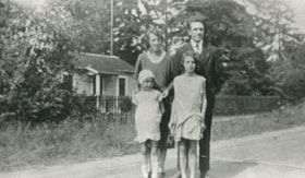
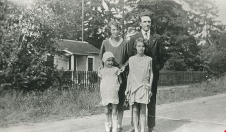
Butler family
https://search.heritageburnaby.ca/link/archivedescription35478
- Repository
- City of Burnaby Archives
- Date
- 1930 (date of original), copied 1986
- Collection/Fonds
- Burnaby Historical Society fonds
- Description Level
- Item
- Physical Description
- 1 photograph : b&w ; 12.7 x 17.8 cm print
- Scope and Content
- Photograph of (back, from left); (parents) Margaret and Edwin Butler; (front, from left) Gladys and Hazel Butler. The Butlers lived at 278 14th Avenue (later renumbered 8062 14th Avenue), East Burnaby.
- Repository
- City of Burnaby Archives
- Date
- 1930 (date of original), copied 1986
- Collection/Fonds
- Burnaby Historical Society fonds
- Subseries
- Pioneer Tales subseries
- Physical Description
- 1 photograph : b&w ; 12.7 x 17.8 cm print
- Description Level
- Item
- Record No.
- 204-336
- Access Restriction
- No restrictions
- Reproduction Restriction
- No known restrictions
- Accession Number
- BHS1988-03
- Scope and Content
- Photograph of (back, from left); (parents) Margaret and Edwin Butler; (front, from left) Gladys and Hazel Butler. The Butlers lived at 278 14th Avenue (later renumbered 8062 14th Avenue), East Burnaby.
- Media Type
- Photograph
- Notes
- Title based on contents of photograph
- Annotation above photograph reads, "The Family - 1930"
- Geographic Access
- 14th Avenue
- Street Address
- 8062 14th Avenue
- Historic Neighbourhood
- East Burnaby (Historic Neighbourhood)
- Planning Study Area
- Second Street Area
Images

Ceiling in parlour
https://search.heritageburnaby.ca/link/museumdescription10812
- Repository
- Burnaby Village Museum
- Date
- April 8, 1988
- Collection/Fonds
- Burnaby Village Museum fonds
- Description Level
- Item
- Physical Description
- 1 photograph : col. negative ; 35 mm
- Scope and Content
- Photograph of the tin ceiling in the parlour inside of the Love farmhouse while it was located at 7651 Cumberland Street (the corner of 14th Avenue and Cumberland Street). The photograph was taken of the house once it was saved and acquired by the Burnaby Village Museum.
- Repository
- Burnaby Village Museum
- Collection/Fonds
- Burnaby Village Museum fonds
- Series
- Jesse Love farmhouse series
- Description Level
- Item
- Physical Description
- 1 photograph : col. negative ; 35 mm
- Material Details
- Photograph is part of Film roll "F" - 23 colour photographs that are a part of a collection described as BV018.41.82
- Scope and Content
- Photograph of the tin ceiling in the parlour inside of the Love farmhouse while it was located at 7651 Cumberland Street (the corner of 14th Avenue and Cumberland Street). The photograph was taken of the house once it was saved and acquired by the Burnaby Village Museum.
- Subjects
- Buildings - Heritage
- Geographic Access
- Cumberland Street
- Street Address
- 7651 Cumberland Street
- Accession Code
- BV018.41.334
- Access Restriction
- No restrictions
- Reproduction Restriction
- No known restrictions
- Date
- April 8, 1988
- Media Type
- Photograph
- Historic Neighbourhood
- East Burnaby (Historic Neighbourhood)
- Planning Study Area
- Cariboo-Armstrong Area
- Related Material
- See BV018.41.82 for File Level Description
- Scan Resolution
- 2400
- Scan Date
- 13-May-19
- Scale
- 100
- Photographer
- Wolf, Jim
- Notes
- Title based on contents of photograph
- Photograph is a part of file level description "Photographic documentation of changes and move" BV018.41.82
Images

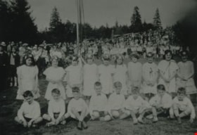
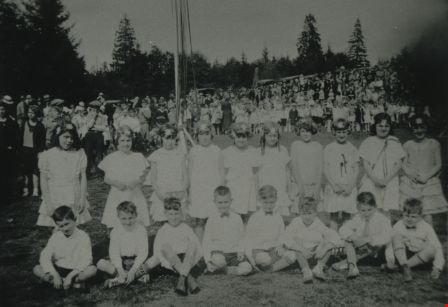
Children at May Day
https://search.heritageburnaby.ca/link/archivedescription35975
- Repository
- City of Burnaby Archives
- Date
- May 1930
- Collection/Fonds
- Burnaby Historical Society fonds
- Description Level
- Item
- Physical Description
- 1 photograph : b&w ; 6.5 x 9.5 cm print
- Scope and Content
- Photograph of two rows of Maypole dancers during Burnaby May Day at Burnaby Park. A large group of spectators is visible in the background.
- Repository
- City of Burnaby Archives
- Date
- May 1930
- Collection/Fonds
- Burnaby Historical Society fonds
- Subseries
- Edmonds School subseries
- Physical Description
- 1 photograph : b&w ; 6.5 x 9.5 cm print
- Description Level
- Item
- Record No.
- 207-024
- Access Restriction
- No restrictions
- Reproduction Restriction
- No known restrictions
- Accession Number
- BHS1988-07
- Scope and Content
- Photograph of two rows of Maypole dancers during Burnaby May Day at Burnaby Park. A large group of spectators is visible in the background.
- Subjects
- Events - May Day
- Clothing
- Media Type
- Photograph
- Notes
- Title based on contents of photograph
- Geographic Access
- Robert Burnaby Park
- Wedgewood Street
- Street Address
- 8155 Wedgewood Street
- Historic Neighbourhood
- East Burnaby (Historic Neighbourhood)
- Planning Study Area
- Lakeview-Mayfield Area
Images

Cooling cupboard in basement
https://search.heritageburnaby.ca/link/museumdescription10867
- Repository
- Burnaby Village Museum
- Date
- April 11, 1988
- Collection/Fonds
- Burnaby Village Museum fonds
- Description Level
- Item
- Physical Description
- 1 photograph : b&w negative ; 35 mm
- Scope and Content
- Photograph of cooling cupboard in along the wast wall in the basement of the Love farmhouse located at 7651 Cumberland Street (the corner of 14th Avenue and Cumberland Street). The photograph was taken of the house once it was saved and acquired by the Burnaby Village Museum.
- Repository
- Burnaby Village Museum
- Collection/Fonds
- Burnaby Village Museum fonds
- Series
- Jesse Love farmhouse series
- Description Level
- Item
- Physical Description
- 1 photograph : b&w negative ; 35 mm
- Material Details
- Photograph is part of Film roll "H" - 36 b&w photographs that are a part of a collection described as BV018.41.82
- Scope and Content
- Photograph of cooling cupboard in along the wast wall in the basement of the Love farmhouse located at 7651 Cumberland Street (the corner of 14th Avenue and Cumberland Street). The photograph was taken of the house once it was saved and acquired by the Burnaby Village Museum.
- Subjects
- Buildings - Heritage
- Geographic Access
- Cumberland Street
- Street Address
- 7651 Cumberland Street
- Accession Code
- BV018.41.389
- Access Restriction
- No restrictions
- Reproduction Restriction
- No known restrictions
- Date
- April 11, 1988
- Media Type
- Photograph
- Historic Neighbourhood
- East Burnaby (Historic Neighbourhood)
- Planning Study Area
- Cariboo-Armstrong Area
- Related Material
- See BV018.41.82 for File Level Description
- Scan Resolution
- 2400
- Scan Date
- 6/3/2019
- Scale
- 100
- Photographer
- Wolf, Jim
- Notes
- Title based on contents of photograph
- Photograph is a part of file level description "Photographic documentation of changes and move" BV018.41.82
Images


C room north wall and window
https://search.heritageburnaby.ca/link/museumdescription10767
- Repository
- Burnaby Village Museum
- Date
- May 12, 1988
- Collection/Fonds
- Burnaby Village Museum fonds
- Description Level
- Item
- Physical Description
- 1 photograph : b&w negative ; 35 mm
- Scope and Content
- Photograph of the north wall and window in room "C", upstairs in the Love farmhouse while it was located at 7651 Cumberland Street (the corner of 14th Avenue and Cumberland Street).
- Repository
- Burnaby Village Museum
- Collection/Fonds
- Burnaby Village Museum fonds
- Series
- Jesse Love farmhouse series
- Description Level
- Item
- Physical Description
- 1 photograph : b&w negative ; 35 mm
- Material Details
- Photograph is part of Film roll "D" - 37 b&w photographs that are a part of a collection described as BV018.41.82
- Scope and Content
- Photograph of the north wall and window in room "C", upstairs in the Love farmhouse while it was located at 7651 Cumberland Street (the corner of 14th Avenue and Cumberland Street).
- Subjects
- Buildings - Heritage
- Geographic Access
- Cumberland Street
- Street Address
- 7651 Cumberland Street
- Accession Code
- BV018.41.290
- Access Restriction
- No restrictions
- Reproduction Restriction
- No known restrictions
- Date
- May 12, 1988
- Media Type
- Photograph
- Historic Neighbourhood
- East Burnaby (Historic Neighbourhood)
- Planning Study Area
- Cariboo-Armstrong Area
- Related Material
- See BV018.41.82 for File Level Description
- Scan Resolution
- 2400
- Scan Date
- 13-May-19
- Scale
- 100
- Photographer
- Wolf, Jim
- Notes
- Title based on contents of photograph
- Photograph is a part of file level description "Photographic documentation of changes and move" BV018.41.82
Images
