Recommendation of the Engineer re Murray Road and Access to Block 6, DL 35
https://search.heritageburnaby.ca/link/councilreport68892
- Repository
- City of Burnaby Archives
- Report ID
- 59831
- Meeting Date
- 3-Jul-1922
- Format
- Council - Committee Report
- Collection/Fonds
- City Council and Office of the City Clerk fonds
- Repository
- City of Burnaby Archives
- Report ID
- 59831
- Meeting Date
- 3-Jul-1922
- Format
- Council - Committee Report
- Collection/Fonds
- City Council and Office of the City Clerk fonds
Documents
Sale of Block 1 DL 164 to John Murray
https://search.heritageburnaby.ca/link/councilreport80490
- Repository
- City of Burnaby Archives
- Report ID
- 83976
- Meeting Date
- 3-Jan-1921
- Format
- Council - Committee Report
- Collection/Fonds
- City Council and Office of the City Clerk fonds
- Repository
- City of Burnaby Archives
- Report ID
- 83976
- Meeting Date
- 3-Jan-1921
- Format
- Council - Committee Report
- Collection/Fonds
- City Council and Office of the City Clerk fonds
Documents
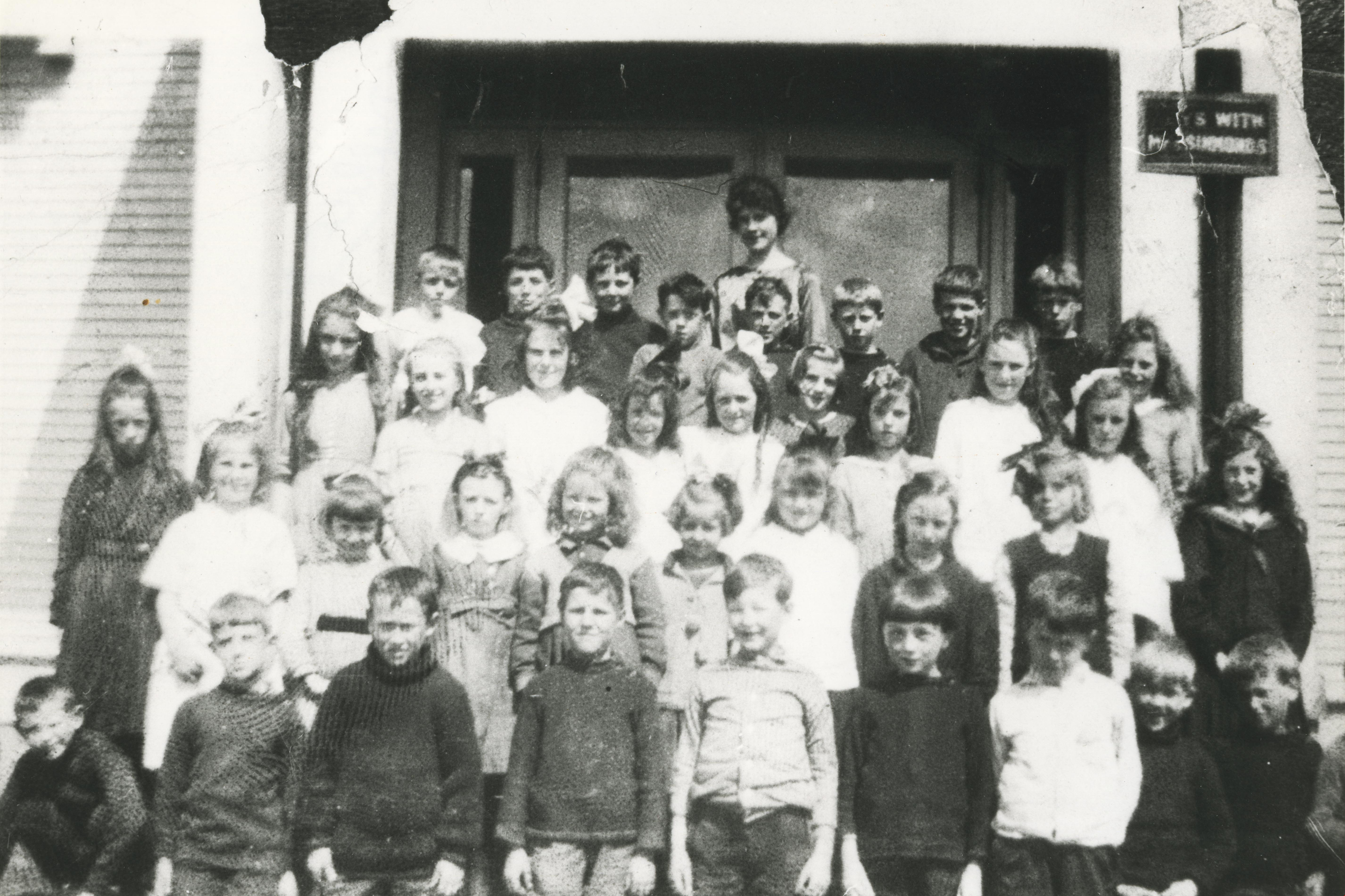
Second Street School Class
https://search.heritageburnaby.ca/link/archivedescription34806
- Repository
- City of Burnaby Archives
- Date
- 1920 (date of original), copied 1985
- Collection/Fonds
- Burnaby Historical Society fonds
- Description Level
- Item
- Physical Description
- 1 photograph : b&w ; 20.2 x 25.3 cm print
- Scope and Content
- Photograph of a Second Street School class taken outside of the school. Back row, left to right: Kenneth Wilson, Victor Spong, Gordon Ramsey, Murdoch McLeod, Keith Waite, Frank Trewern, Herbert Spong, and Charlie Trewern. Next row, left to right: Mina Fraser, Florence Wilson, Ethel Beamish, Eliza…
- Repository
- City of Burnaby Archives
- Date
- 1920 (date of original), copied 1985
- Collection/Fonds
- Burnaby Historical Society fonds
- Subseries
- Ethel Derrick subseries
- Physical Description
- 1 photograph : b&w ; 20.2 x 25.3 cm print
- Description Level
- Item
- Record No.
- 136-002
- Access Restriction
- No restrictions
- Reproduction Restriction
- No known restrictions
- Accession Number
- BHS1985-05
- Scope and Content
- Photograph of a Second Street School class taken outside of the school. Back row, left to right: Kenneth Wilson, Victor Spong, Gordon Ramsey, Murdoch McLeod, Keith Waite, Frank Trewern, Herbert Spong, and Charlie Trewern. Next row, left to right: Mina Fraser, Florence Wilson, Ethel Beamish, Elizabeth Murray, Gladys Brown, Gwen Allman, Ethel Meade, Jean Campbell, Dorothy White, Masie Frost, and Doreen Burton. 2nd row from front, left to right: Madge Donald, Ilma Beamish, Annie McDonald, Edna Townsend, Jessie Murray, Frances Atkinson, Elizabeth Moody, Helen Sutherland, and Helen Spong. Front row, left to right: Leslie Roy, Harold Allman, Bernard Gosse, Stanley Owen, Ralph Stapely, Percey Bettles, Archie Card, Norman Swift, and Gilbert Bettles. The teacher, at back, is Miss Sutcliffe.
- Subjects
- Occupations - Teachers
- Media Type
- Photograph
- Notes
- Title based on contents of photograph
- Geographic Access
- 2nd Street
- Street Address
- 7502 2nd Street
- Historic Neighbourhood
- East Burnaby (Historic Neighbourhood)
- Planning Study Area
- Second Street Area
Images
![Brothers Earl and Norman Wild, [1925] - 1990 thumbnail](/media/hpo/_Data/_Archives_Images/_Unrestricted/540/548-003.jpg?width=280)
Brothers Earl and Norman Wild
https://search.heritageburnaby.ca/link/archivedescription80586
- Repository
- City of Burnaby Archives
- Date
- [1925] - 1990
- Collection/Fonds
- Murray family fonds
- Description Level
- Item
- Physical Description
- 1 photograph : b&w ; 7 x 7 cm
- Scope and Content
- Photograph of brothers Earl and Norman Wild in Idaho, in the United States of America (USA). Norman is holding an unidentified toddler on one arm, and has his other arm around his brother.
- Repository
- City of Burnaby Archives
- Date
- [1925] - 1990
- Collection/Fonds
- Murray family fonds
- Physical Description
- 1 photograph : b&w ; 7 x 7 cm
- Description Level
- Item
- Record No.
- 548-003
- Access Restriction
- No restrictions
- Reproduction Restriction
- No restrictions
- Accession Number
- 2012-31
- Scope and Content
- Photograph of brothers Earl and Norman Wild in Idaho, in the United States of America (USA). Norman is holding an unidentified toddler on one arm, and has his other arm around his brother.
- Names
- Wild, Norman
- Wild, Earl
- Media Type
- Photograph
- Notes
- Title based on contents of photograph
- Note in blue ink on verso of photograph reads: "Norman's brother Earl + Norman. Idaho USA"
Images
![Brothers Earl and Norman Wild, [1925] - 1990 thumbnail](/media/hpo/_Data/_Archives_Images/_Unrestricted/540/548-003.jpg)
Election Results
https://search.heritageburnaby.ca/link/councilreport60956
- Repository
- City of Burnaby Archives
- Report ID
- 26436
- Meeting Date
- 24-Jan-1924
- Format
- Council - Mayor/Councillor/Staff Report
- Collection/Fonds
- City Council and Office of the City Clerk fonds
- Repository
- City of Burnaby Archives
- Report ID
- 26436
- Meeting Date
- 24-Jan-1924
- Format
- Council - Mayor/Councillor/Staff Report
- Collection/Fonds
- City Council and Office of the City Clerk fonds
Documents
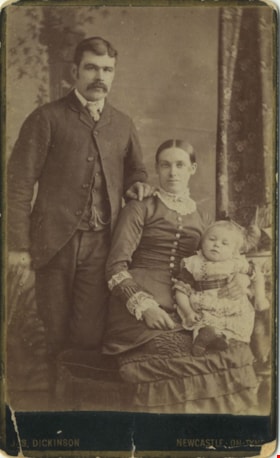
Ellenor Murray's brother
https://search.heritageburnaby.ca/link/archivedescription80585
- Repository
- City of Burnaby Archives
- Collection/Fonds
- Murray family fonds
- Description Level
- Item
- Physical Description
- 1 photograph : sepia (cabinet card) ; 9 x 6 cm, mounted on card 10 x 6 cm
- Scope and Content
- Photograph of a family of three taken at a photographic studio in Newcastle-On-Tyne. Either the man or the child in the photograph has been identified as Ellenor Murray's brother.
- Repository
- City of Burnaby Archives
- Collection/Fonds
- Murray family fonds
- Physical Description
- 1 photograph : sepia (cabinet card) ; 9 x 6 cm, mounted on card 10 x 6 cm
- Description Level
- Item
- Record No.
- 548-002
- Access Restriction
- No restrictions
- Reproduction Restriction
- No known restrictions
- Accession Number
- 2012-31
- Scope and Content
- Photograph of a family of three taken at a photographic studio in Newcastle-On-Tyne. Either the man or the child in the photograph has been identified as Ellenor Murray's brother.
- Media Type
- Photograph
- Photographer
- Dickson, Jas.
- Notes
- Title based on contents of photograph
- Note in pencil on verso of photograph reads: "Mother's Brother"
- Photographer's studio markings on recto of cabinet card read: "Jas. Dickinson / Newcastle-On-Tyne"
- Photographers studio markings on verso of cabinet card read: "The Portrait / City Gallery / Photographic Artist / Jas Dickinson / Grainger Street Newcastle-On-Tyne / Negatives Kept / Additional Copies Can Always Be Obtained / Portraits of Every Description Enlarged / Portrait Clubs."
Images

LaFavor Family fonds
https://search.heritageburnaby.ca/link/archivedescription72548
- Repository
- City of Burnaby Archives
- Date
- [191-]; 1953-1955
- Collection/Fonds
- LaFavor Family fonds
- Description Level
- Fonds
- Physical Description
- 0.5 cm. of textual records (newsprint) and 59 photographs : sepia postcards ; 8 x 13 cm
- Scope and Content
- Fonds consists of photographic postcards (some are duplications) depicting the village of Barnet in Burnaby along with newspaper clippings pertaining to Barnet Village from the 1950s.
- Repository
- City of Burnaby Archives
- Date
- [191-]; 1953-1955
- Collection/Fonds
- LaFavor Family fonds
- Physical Description
- 0.5 cm. of textual records (newsprint) and 59 photographs : sepia postcards ; 8 x 13 cm
- Description Level
- Fonds
- Accession Number
- 2007-03
- Scope and Content
- Fonds consists of photographic postcards (some are duplications) depicting the village of Barnet in Burnaby along with newspaper clippings pertaining to Barnet Village from the 1950s.
- History
- Orville Glen LaFavor was born in Willow City, North Dakota, on May 31, 1903, to Harvey M. LaFavor. On April 20, 1924, Orville married Cathryn Arlou "Kate" Lewis. In that same year, Orville and Kate moved to Barnet Village to join Harvey and his wife. Orville and Kate had five children who were all born in Barnet: Lewis in September 1925, Irene in December 1927, Clyde Martin in July 1930, Florence Alice in March 1933 and Cathryn Bernice on April 24, 1934. Orville worked as a trimmer for the Barnet Lumber Company. He and his family lived at Number 10 on the Barnet property. In 1924, he began working at the mills and retired in 1960. During the war, he made blackout blinds and worked as a warden or home guard in Vancouver. Kate LaFavor stayed at home to look after the five children. All of the children went to Barnet School until grade five, when they had to bus up to Capitol Hill in North Burnaby. Once evictions began in Barnet in 1953, Orville bought the house from the municipality and moved it to Port Coquitlam. Orville's brother, Vern Victor LaFavor, married Irene Winnifred "Winnie" Warner on August 6, 1928. Clyde and Lou LaFavor also worked in the mill. Fred Marshall and his brother Roy Marshall lived and worked at the mill and were uncles to the LaFavor children. Harvey, the grandfather of the children, worked as a millwright and had a section in the village for gardening, which he tended to regularly. He had horses that worked with him at the mill and later on the construction of Barnet Road, allowing him to make money during the Depression. During a strike for higher wages at the Barnet Sawmill, Harvey was badly beaten. Murray Glen "Bud" LaFavor was born on December 13, 1944, in New Westminster. He had four sisters: Irene, Catherine, Carol, and Rene. He worked as a volunteer fireman for 25 years and was employed by the District of 100 Mile House. He died in 2009. Lewis LaFavor, son of Orville and Kate, joined the navy and survied World War II. Catherine Bernice (LaFavor) Nelson, daughter of Orville and Kate, died July 7, 2011, in Nelson, British Columbia.
- Media Type
- Textual Record
- Photograph
- Creator
- LaFavor family
- Notes
- Photo catalogue 540, MSS166
The outline of history : being a plain history of life and mankind
https://search.heritageburnaby.ca/link/museumlibrary3097
- Repository
- Burnaby Village Museum
- Edition
- 3rd ed. rev. and rearranged
- Publication Date
- 1922
- Call Number
- 909 WEL Copy 1
- Repository
- Burnaby Village Museum
- Collection
- Special Collection
- Material Type
- Book
- Accession Code
- HV972.165.64
- Call Number
- 909 WEL Copy 1
- Edition
- 3rd ed. rev. and rearranged
- Contributor
- Horrabin, J. F. (James Francis), 1884-1962
- Place of Publication
- New York
- Publisher
- The MacMillan Company
- Publication Date
- 1922
- Physical Description
- xxi, 1171 p. : ill., maps ; 23 cm.
- Inscription
- "W45" [phrase is crossed out and handwritten in black ink on front pastedown] "J.W. 23" [handwritten in black ink at top of front endpaper] "MAR 23" [stamped in purple ink at top of front endpaper]
- Library Subject (LOC)
- World history
- Notes
- "Educational edition"--p. before title page.
- "Written originally with the advice and editorial help of Mr. Ernest Barker, Sir H.H. Johnston, Sir E. Ray Lankester and Professor Gilbert Murray"--title page.
- "and illustrated by J.F. Horrabin"--title page.
- Author's given name and dates: Wells, H.G. (Herbert George), 1866-1946
- Illustrator's given name and dates: Horrabin, J.F. (James Francis), 1884-1962
- Copy 1 of 2
![Survey and Subdivision plans in New Westminster District Group 1 – Burnaby
, [1861]-[1910] thumbnail](/media/hpo/_Data/_BVM_Cartographic_Material/1977/1977_0093_0019a_001.jpg?width=280)
Survey and Subdivision plans in New Westminster District Group 1 – Burnaby
https://search.heritageburnaby.ca/link/museumdescription6988
- Repository
- Burnaby Village Museum
- Date
- [1861]-[1910]
- Collection/Fonds
- Burnaby Village Museum Map collection
- Description Level
- File
- Physical Description
- 14 plans : 3 plans : black ink on paper hand col. + 7 plans : black ink on paper + 4 plans : graphite on paper mounted on 2 sides of cardboard 76 x 102 cm
- Scope and Content
- Item consists of a large board of four New Westminster District Gp 1 - subdivision plans mounted on one side and ten New Westminster District Gp 1 - subdivision plans mounted on the other side. Side A: 1. "Plan /of / Lots 166A, 166 and 167 /, Gr.1, N.W.D. / Showing Misconstructed Roads in Gree…
- Repository
- Burnaby Village Museum
- Collection/Fonds
- Burnaby Village Museum Map collection
- Description Level
- File
- Physical Description
- 14 plans : 3 plans : black ink on paper hand col. + 7 plans : black ink on paper + 4 plans : graphite on paper mounted on 2 sides of cardboard 76 x 102 cm
- Material Details
- Scales [between 1:2376 and 1:7920]
- Index number on edge of board reads: "19"
- Scope and Content
- Item consists of a large board of four New Westminster District Gp 1 - subdivision plans mounted on one side and ten New Westminster District Gp 1 - subdivision plans mounted on the other side. Side A: 1. "Plan /of / Lots 166A, 166 and 167 /, Gr.1, N.W.D. / Showing Misconstructed Roads in Green / 5 chs = 1 in.". (plan is drawn in black ink and hand coloured in red, green and orange ink). A section in the centre of the plan is coloured in red ink and identified as "C.S. Richmond" running from the North Arm of Fraser River to Wiggins Road and divided by "New Wiggins Rd. (as gazetted)" (coloured in orange ink) and two"Constructed Road(s)" (coloured in green ink). Plan is initialed by: "RB" [sic] (in blue pencil crayon) 2. Plan of / Subdivision of / Lot 166 / Group One / New Westminster District / Scale 4 chs = 1 in. / Map No 524". Plan is drawn in graphite and signed by "Surrig [sic] Welhams [sic] / P.L.S." Plan is initialed by: "RB" [sic] (in blue pencil crayon) 3. Plan of "Survey / of Highway / For / Burnaby Council / in / Lots 13 _14 / Group One / Scale 4 chs = 1 in." Signed by "Albert J. Hill, P.L.S." Caribou Street and Caribou Road run through the centre of the plan. Plan is stamped: "Albert J. Hill, Civil Engineer / and / Provincial Land Surveyor, / New Westminster, / B.C.". Plan is initialed by: "RB" [sic] (in blue pencil crayon) 4. A Plan of Lots 166A, 166 and 167, Group One, New Westminster District (drawn in graphite). A section in the centre of the plan is identified as "C.S. Richmond" running from the North Arm of Fraser River and divided by "New Wiggins Rd. (as gazetted)" and two "Constructed Road(s)". Plan is initialed by: "RB" [sic] (in blue pencil crayon) Side B: 1. Small plan drawn in black ink (no title) identifying lots north of the "North Arm" of the Fraser River. Lots identified include: Lot 99, Lot 98, Lot 157, Lot 158, Lot 163, Lot 162, Lot 159, Lot 163, Lot 162, Lot 165, Lot 166A, Lot 155B, Lot 155A and Lot 159. "Scale 40 chains to one inch" . Plan is initialed by: "RB" [sic] (in blue pencil crayon) (Geographic location: Burnaby) 2. Small plan drawn in black ink (no title) identifying lots north of the North Arm of the Fraser River as "Lots 155, 155A, 155B, 155C, 162, 163, 164, 165, 166A and 167". Plan is initialed by: "RB" [sic] (in blue pencil crayon) (Geographic location: Burnaby) 3. Small plan drawn in black ink (no title) which identifies "Lot 151 / Reserve/ for / Race Course"; "Reserve / 64 A / L. 152 G.1"; and other Lots: 32, 33, 34, 35, 36, 38, 39. The plan is signed "Surveyor G.Turn [sic] July / 61 / from Vol 40 R.L. notes [sic]" Plan is stamped: "Albert J. Hill, Civil Engineer / and / Provincial Land Surveyor, / New Westminster, / B.C." Plan is initialed by: "RB" [sic] (in blue pencil crayon) (Geographic location: Burnaby) 4. Small plan drawn in black in with faded red colouring on centre lot identified as "Lot 34" running north from "Vancouver Road" . Plan is stamped: "Albert J. Hill, Civil Engineer / and / Provincial Land Surveyor, / New Westminster, / B.C." Plan is initialed by: "RB" [sic] (in blue pencil crayon) (Geographic location: Burnaby) 5. Plan drawn in graphite and identified as "Lot 98, Gr.1," along with the intials "RB" [sic] (both are handwritten in blue crayon pencil on top of plan) The B.C.E.Railway is identified running through the plan along with Jubilee Road and Royal Oak Road. The plan is signed with the name "Wm. Murray" and the Plan is stamped: "Albert J. Hill, Civil Engineer / and / Provincial Land Surveyor, / New Westminster, / B.C.". (Geographic location: Burnaby) 6. Plan drawn in graphite identified as "Port Lot 13, Gr.1" along with the intials "RB" [sic] (both are handwritten in blue crayon pencil on top of plan) Plan is stamped: "Albert J. Hill, Civil Engineer / and / Provincial Land Surveyor, / New Westminster, / B.C.". (Geographic location: Burnaby) 7.Plan drawn in black ink and identified as "Lot 98 G.1" along with the intials "RB" [sic] (both are handwritten in blue crayon pencil on top of plan). A "Road Reservation" is identified running north between "Electric Tramway" and connecting with "Royal Oak Road". Plan is stamped: "Albert J. Hill, Civil Engineer / and / Provincial Land Surveyor, / New Westminster, / B.C." (Geographic location: Burnaby) 8. Plan drawn in black ink and divided into two sections, the upper plan is identified as "Portion / Lots 100 / area / 101, Gr.1" and the lower plan is identified as "Portion L. 3 G. 1" along with the intials "RB" [sic] (these identifiers are handwritten in blue crayon pencil on top of the plan). Portions of Lot 100 and Lot 101 are each divided into 6 sections and the Portion of Lot 3 plan is divided into 24 sections. The plan includes a note in black ink that reads: " Received from Wm Fromme [sic] / from Wm. Trapp / Nov. 28, 1895 / A. J. T...[sic]". (Geographic location: Burnaby) 9. Plan drawn in black ink (no title) identifying soil, buildings and geographic features in southern Burnaby. The plan is bordered by "New Westminster City" (Tenth Avenue and DL 172) to the south east and DL 173 to the south, DL 158 to the west and the B.C.E. Tramway to the north. Plan includes District Lots: 155A, 158, 159, 171, 160, 53 and 95 and identifies soil, marshland and ravines throughout. Plan identifies the following features: a "Team Road" running through Lots 158 and 159 along with "Fair Orchard Soil / Even Surface Throughout / No Ravines", "Gravel and Shingle" (bottom of Lot 158), "North Arm Road" crossing "Byrne Road" and connecting with "Power House Road" which runs north to connect with "Highland Park Station" and the B.C.E. Tramway, "Power Ho" in the northeast corner of DL 160, a "Brook" connected with a "Deep Ravine" running between DL 53, DL 95 and DL 160 along with "Good Soil" and "Fair Orchard Soil" identified nearby in DL 95. Scale is identified as "10 chs = 1 in." Plan is stamped: "Albert J. Hill, Civil Engineer / and / Provincial Land Surveyor, / New Westminster, / B.C." Plan is initialed by: "RB" [sic] (in blue pencil crayon) (Geographic location: Burnaby) 10. Plan drawn in black ink (no title) with Burnaby Lake and Deer Lake at the centre. The plan is bordered by the following District Lots identified as: 117, 118 and 68 to the west, Lots 80, 79 and 85 to the southwest, Lots 11, 13, and 1 (City of New Westminster) to the south east, the North Road boundary to the east and Lots 8, 56, 57, 59, and 136 to the North. The lower right hand corner of the plan has a small inset which reads: "Burnaby Lake" and "Page 19 R.B. Notes". Plan is initialed by: "RB" [sic] (in blue pencil crayon) (Geographic location: Burnaby)
- Creator
- Hill, Albert James
- Accession Code
- HV977.93.19
- Access Restriction
- No restrictions
- Reproduction Restriction
- No known restrictions
- Date
- [1861]-[1910]
- Media Type
- Cartographic Material
- Scan Resolution
- 300
- Scale
- 72
- Notes
- Title based on contents of file
- Scale is measured in chains. (One chain equals 792 inches)
- The term "Lot" can also refer to a "District Lot”
- Some plans are stamped: "Albert J. Hill, Civil Engineer / and / Provincial Land Surveyor, / New Westminster, / B.C." and intialed: "RB" [sic]
Images
![Survey and Subdivision plans in New Westminster District Group 1 – Burnaby
, [1861]-[1910] thumbnail](/media/hpo/_Data/_BVM_Cartographic_Material/1977/1977_0093_0019a_001.jpg)
