Narrow Results By
Subject
- Agricultural Tools and Equipment 1
- Agriculture - Farms 1
- Animals - Dogs 1
- Animals - Fish 2
- Construction 1
- Construction - Road Construction 1
- Construction Tools and Equipment 2
- Energy Production Tools and Equipment 1
- Geographic Features - Canyons 2
- Geographic Features - Creeks 1
- Geographic Features - Dykes 3
- Geographic Features - Islands 1

At the river's edge
https://search.heritageburnaby.ca/link/archivedescription34445
- Repository
- City of Burnaby Archives
- Date
- 1927
- Collection/Fonds
- Burnaby Historical Society fonds
- Description Level
- Item
- Physical Description
- 1 photograph : b&w ; 6.8 x 12 cm on page 17.4 x 26 cm
- Scope and Content
- Photograph of a house sitting near the river bank in the vicinity of Nicomen Island, Deroche and Dewndey. Mountains are visible in the background
- Repository
- City of Burnaby Archives
- Date
- 1927
- Collection/Fonds
- Burnaby Historical Society fonds
- Subseries
- Peers family subseries
- Physical Description
- 1 photograph : b&w ; 6.8 x 12 cm on page 17.4 x 26 cm
- Description Level
- Item
- Record No.
- 020-152
- Access Restriction
- No restrictions
- Reproduction Restriction
- No known restrictions
- Accession Number
- BHS2007-04
- Scope and Content
- Photograph of a house sitting near the river bank in the vicinity of Nicomen Island, Deroche and Dewndey. Mountains are visible in the background
- Media Type
- Photograph
- Notes
- Title based on contents of photograph
Images


Bridge over a frozen river
https://search.heritageburnaby.ca/link/archivedescription34449
- Repository
- City of Burnaby Archives
- Date
- 1925
- Collection/Fonds
- Burnaby Historical Society fonds
- Description Level
- Item
- Physical Description
- 1 photograph : sepia ; 6.1 x 11.8 cm
- Scope and Content
- Photograph of a railroad bridge spanning a river that has frozen over.
- Repository
- City of Burnaby Archives
- Date
- 1925
- Collection/Fonds
- Burnaby Historical Society fonds
- Subseries
- Peers family subseries
- Physical Description
- 1 photograph : sepia ; 6.1 x 11.8 cm
- Description Level
- Item
- Record No.
- 020-156
- Access Restriction
- No restrictions
- Reproduction Restriction
- No known restrictions
- Accession Number
- BHS2007-04
- Scope and Content
- Photograph of a railroad bridge spanning a river that has frozen over.
- Subjects
- Structures - Bridges
- Transportation - Rail
- Natural Phenomena - Snow
- Geographic Features - Rivers
- Media Type
- Photograph
- Notes
- Title based on contents of photograph
Images


Bridge over Deer Lake Brook
https://search.heritageburnaby.ca/link/archivedescription39323
- Repository
- City of Burnaby Archives
- Date
- 1922
- Collection/Fonds
- Peers Family and Hill Family fonds
- Description Level
- Item
- Physical Description
- 1 photograph : b&w ; 6.2 x 9.8 cm on page 24.5 x 32.5 cm (pasted in album)
- Scope and Content
- Photograph of a bridge over Deer Lake Brook, covered with snow. This photograph was probably taken on the property belonging to Claude Hill, known as "Brookfield."
- Repository
- City of Burnaby Archives
- Date
- 1922
- Collection/Fonds
- Peers Family and Hill Family fonds
- Physical Description
- 1 photograph : b&w ; 6.2 x 9.8 cm on page 24.5 x 32.5 cm (pasted in album)
- Description Level
- Item
- Record No.
- 477-642
- Access Restriction
- No restrictions
- Reproduction Restriction
- No known restrictions
- Accession Number
- 2007-12
- Scope and Content
- Photograph of a bridge over Deer Lake Brook, covered with snow. This photograph was probably taken on the property belonging to Claude Hill, known as "Brookfield."
- Media Type
- Photograph
- Notes
- Title based on contents of photograph
- Geographic Access
- Deer Lake Brook
- Deer Lake Avenue
- Street Address
- 6501 Deer Lake Avenue
- Historic Neighbourhood
- Burnaby Lake (Historic Neighbourhood)
- Planning Study Area
- Morley-Buckingham Area
Images

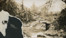
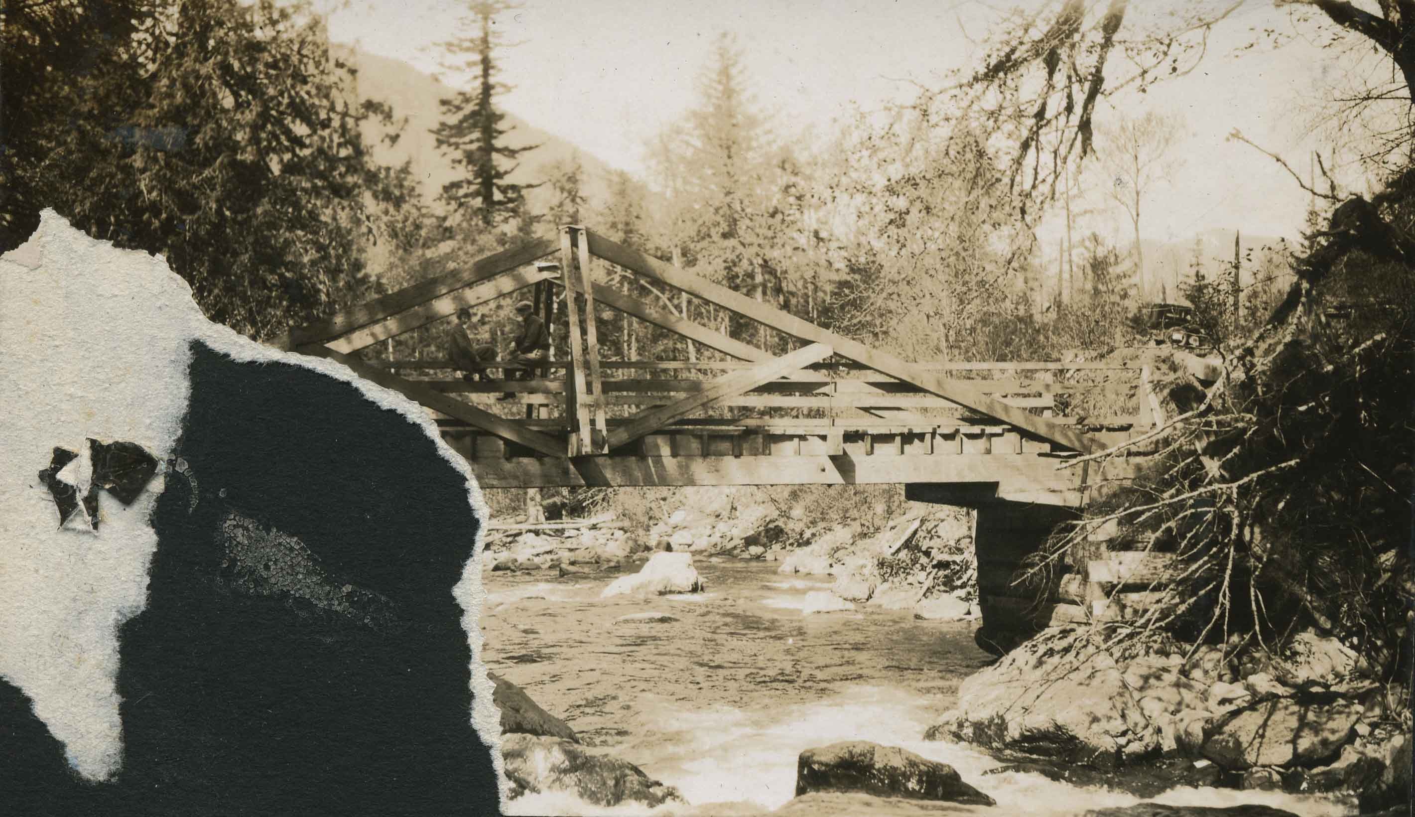
Bridge over Jones Creek
https://search.heritageburnaby.ca/link/archivedescription34389
- Repository
- City of Burnaby Archives
- Date
- 1926
- Collection/Fonds
- Burnaby Historical Society fonds
- Description Level
- Item
- Physical Description
- 1 photograph : b&w ; 7 x 12 cm on page 17.5 x 26.5 cm
- Scope and Content
- Photograph ofa wooden bridge spanning a river identified as Jones Creek. The lower left corner of the photograph has been torn away. This photograph appears to have been taken by Arthur Peers, who travelled through the Fraser River Valley and worked on the construction of the Trans-Provincial High…
- Repository
- City of Burnaby Archives
- Date
- 1926
- Collection/Fonds
- Burnaby Historical Society fonds
- Subseries
- Peers family subseries
- Physical Description
- 1 photograph : b&w ; 7 x 12 cm on page 17.5 x 26.5 cm
- Description Level
- Item
- Record No.
- 020-096
- Access Restriction
- No restrictions
- Reproduction Restriction
- No known restrictions
- Accession Number
- BHS2007-04
- Scope and Content
- Photograph ofa wooden bridge spanning a river identified as Jones Creek. The lower left corner of the photograph has been torn away. This photograph appears to have been taken by Arthur Peers, who travelled through the Fraser River Valley and worked on the construction of the Trans-Provincial Highway during the later 1920s.
- Media Type
- Photograph
- Photographer
- Peers, Arthur Francis "Mike"
- Notes
- Title based on caption accompanying photograph
Images
![Burnaby Fraser Foreshore Park, [2000] thumbnail](/media/hpo/_Data/_Archives_Images/_Unrestricted/535/535-2524-1.jpg?width=280)
Burnaby Fraser Foreshore Park
https://search.heritageburnaby.ca/link/archivedescription96970
- Repository
- City of Burnaby Archives
- Date
- [2000]
- Collection/Fonds
- Burnaby NewsLeader photograph collection
- Description Level
- File
- Physical Description
- 2 photographs (tiff) : col.
- Scope and Content
- File contains photographs of Mayor Doug Drummond and another unidentified person posing by the Fraser River in Burnaby Fraser Foreshore Park.
- Repository
- City of Burnaby Archives
- Date
- [2000]
- Collection/Fonds
- Burnaby NewsLeader photograph collection
- Physical Description
- 2 photographs (tiff) : col.
- Description Level
- File
- Record No.
- 535-2524
- Access Restriction
- No restrictions
- Reproduction Restriction
- No restrictions
- Accession Number
- 2018-12
- Scope and Content
- File contains photographs of Mayor Doug Drummond and another unidentified person posing by the Fraser River in Burnaby Fraser Foreshore Park.
- Media Type
- Photograph
- Notes
- Title based on original file name
- Collected by editorial for use in a June 2000 issue of the Burnaby NewsLeader
- Geographic Access
- Burnaby Fraser Foreshore Park
- Historic Neighbourhood
- Fraser Arm (Historic Neighbourhood)
- Planning Study Area
- Big Bend Area
Images
![Burnaby Fraser Foreshore Park, [2000] thumbnail](/media/hpo/_Data/_Archives_Images/_Unrestricted/535/535-2524-1.jpg)
![Burnaby rivers, [2002] thumbnail](/media/hpo/_Data/_Archives_Images/_Unrestricted/535/535-2800-1.jpg?width=280)
Burnaby rivers
https://search.heritageburnaby.ca/link/archivedescription97440
- Repository
- City of Burnaby Archives
- Date
- [2002]
- Collection/Fonds
- Burnaby NewsLeader photograph collection
- Description Level
- File
- Physical Description
- 4 photographs (tiff) : col.
- Scope and Content
- File contains photographs of people with Burnaby rivers and creeks. Photographs depict BCIT river conservationist Mark Angelo posing in Deer Lake Brook by Burnaby Village Museum, and Lorna Johnson, Gordie Cook, and Jack McAfee enjoying Fraser Foreshore Park by the Fraser River.
- Repository
- City of Burnaby Archives
- Date
- [2002]
- Collection/Fonds
- Burnaby NewsLeader photograph collection
- Physical Description
- 4 photographs (tiff) : col.
- Description Level
- File
- Record No.
- 535-2800
- Access Restriction
- No restrictions
- Reproduction Restriction
- No restrictions
- Accession Number
- 2018-12
- Scope and Content
- File contains photographs of people with Burnaby rivers and creeks. Photographs depict BCIT river conservationist Mark Angelo posing in Deer Lake Brook by Burnaby Village Museum, and Lorna Johnson, Gordie Cook, and Jack McAfee enjoying Fraser Foreshore Park by the Fraser River.
- Media Type
- Photograph
- Photographer
- Bartel, Mario
- Notes
- Title based on caption
- Collected by editorial for use in a September 2002 issue of the Burnaby NewsLeader
- Caption from metadata for 535-2800-1 and 535-2800-2: "Mark Angelo, of BCIT, who's made it his mission to save and preserve Burnaby's rivers and creeks, says he's particularly proud of Deer Lake Brook, as it babbles through Burnaby Village Museum, on its way to Burnaby Lake."
- Caption from metadata for 535-2800-3: "Lorna Johnson hits a tennis ball out into the Fraser River at Fraser Foreshore Park, to her dog, Keiko."
- Caption from metadata for 535-2800-4: "Gordie Cook and Jack McAfee shoot the breeze and enjoy the sunshine along the Fraser River, at Fraser Foreshore Park in Burnaby."
- Geographic Access
- Deer Lake Brook
- Burnaby Fraser Foreshore Park
- Fraser River
- Historic Neighbourhood
- Fraser Arm (Historic Neighbourhood)
- Burnaby Lake (Historic Neighbourhood)
- Planning Study Area
- Morley-Buckingham Area
- Big Bend Area
Images
![Burnaby rivers, [2002] thumbnail](/media/hpo/_Data/_Archives_Images/_Unrestricted/535/535-2800-1.jpg)

Cable Crossing at Mile 57
https://search.heritageburnaby.ca/link/archivedescription34397
- Repository
- City of Burnaby Archives
- Date
- 1926
- Collection/Fonds
- Burnaby Historical Society fonds
- Description Level
- Item
- Physical Description
- 1 photograph : b&w ; 7.2 x 9.5 cm on page 17.4 x 26.2 cm
- Scope and Content
- Photograph taken looking over a river towards Cheam Peak, which is visible in the background. A cable can be seen stretching over the river. This photograph appears to have been taken by Arthur Peers, who travelled through the Fraser River Valley and worked on the construction of the Trans-Provinc…
- Repository
- City of Burnaby Archives
- Date
- 1926
- Collection/Fonds
- Burnaby Historical Society fonds
- Subseries
- Peers family subseries
- Physical Description
- 1 photograph : b&w ; 7.2 x 9.5 cm on page 17.4 x 26.2 cm
- Description Level
- Item
- Record No.
- 020-104
- Access Restriction
- No restrictions
- Reproduction Restriction
- No known restrictions
- Accession Number
- BHS2007-04
- Scope and Content
- Photograph taken looking over a river towards Cheam Peak, which is visible in the background. A cable can be seen stretching over the river. This photograph appears to have been taken by Arthur Peers, who travelled through the Fraser River Valley and worked on the construction of the Trans-Provincial Highway during the later 1920s.
- Media Type
- Photograph
- Photographer
- Peers, Arthur Francis "Mike"
- Notes
- Title based on caption accompanying photograph
Images

![Cariboo Dam fish weir, [2002] thumbnail](/media/hpo/_Data/_Archives_Images/_Unrestricted/535/535-2996.jpg?width=280)
Cariboo Dam fish weir
https://search.heritageburnaby.ca/link/archivedescription97722
- Repository
- City of Burnaby Archives
- Date
- [2002]
- Collection/Fonds
- Burnaby NewsLeader photograph collection
- Description Level
- Item
- Physical Description
- 1 photograph (tiff) : col.
- Scope and Content
- Photograph of Elmer Rudolph and Bob Henderson helping a salmon through the fish weir at the Cariboo Dam on the Brunette River.
- Repository
- City of Burnaby Archives
- Date
- [2002]
- Collection/Fonds
- Burnaby NewsLeader photograph collection
- Physical Description
- 1 photograph (tiff) : col.
- Description Level
- Item
- Record No.
- 535-2996
- Access Restriction
- No restrictions
- Reproduction Restriction
- No restrictions
- Accession Number
- 2018-12
- Scope and Content
- Photograph of Elmer Rudolph and Bob Henderson helping a salmon through the fish weir at the Cariboo Dam on the Brunette River.
- Media Type
- Photograph
- Photographer
- Bartel, Mario
- Notes
- Title based on caption
- Collected by editorial for use in a November 2002 issue of the Burnaby NewsLeader
- Caption from metadata: "Elmer Rudolph and Bob Henderson help a mature female salmon, weighing about nine pounds, up through the fish weir at the Cariboo dam. The week of heavy rain has finally made conditions favorable for fish to make their journey up the Brunette River from the Fraser, and then on to their spawning beds, and Rudolph is at the dam every day to help them along. On Saturday, in addition to the mature salmon, he also helped four immature males and two 14-inch Cutthroat."
- Geographic Access
- Burnaby Lake
- Brunette River
- Historic Neighbourhood
- Burnaby Lake (Historic Neighbourhood)
- Planning Study Area
- Burnaby Lake Area
Images
![Cariboo Dam fish weir, [2002] thumbnail](/media/hpo/_Data/_Archives_Images/_Unrestricted/535/535-2996.jpg)

Construction of dykes on Nicomen Island
https://search.heritageburnaby.ca/link/archivedescription34330
- Repository
- City of Burnaby Archives
- Date
- 1927
- Collection/Fonds
- Burnaby Historical Society fonds
- Description Level
- Item
- Physical Description
- 1 photograph : sepia ; 5 x 13.5 cm on page 17.5 x 22.7 cm
- Scope and Content
- Photograph of a farm and field along the Fraser River next to dykes that are being built on Nicomen Island.
- Repository
- City of Burnaby Archives
- Date
- 1927
- Collection/Fonds
- Burnaby Historical Society fonds
- Subseries
- Peers family subseries
- Physical Description
- 1 photograph : sepia ; 5 x 13.5 cm on page 17.5 x 22.7 cm
- Description Level
- Item
- Record No.
- 020-037
- Access Restriction
- No restrictions
- Reproduction Restriction
- No known restrictions
- Accession Number
- BHS2007-04
- Scope and Content
- Photograph of a farm and field along the Fraser River next to dykes that are being built on Nicomen Island.
- Media Type
- Photograph
- Notes
- Title based on caption accompanying photograph
Images


Dreadnought Island
https://search.heritageburnaby.ca/link/archivedescription34418
- Repository
- City of Burnaby Archives
- Date
- 1925
- Collection/Fonds
- Burnaby Historical Society fonds
- Description Level
- Item
- Physical Description
- 1 photograph : sepia ; 4 x 7.7 cm on page 17.4 x 26.4 cm
- Scope and Content
- Photograph of Dreadnought Island in the middle of the river. This photograph appears to have been taken by Arthur Peers, who travelled through the Fraser River Valley and worked on the construction of the Trans-Provincial Highway during the later 1920s.
- Repository
- City of Burnaby Archives
- Date
- 1925
- Collection/Fonds
- Burnaby Historical Society fonds
- Subseries
- Peers family subseries
- Physical Description
- 1 photograph : sepia ; 4 x 7.7 cm on page 17.4 x 26.4 cm
- Description Level
- Item
- Record No.
- 020-125
- Access Restriction
- No restrictions
- Reproduction Restriction
- No known restrictions
- Accession Number
- BHS2007-04
- Scope and Content
- Photograph of Dreadnought Island in the middle of the river. This photograph appears to have been taken by Arthur Peers, who travelled through the Fraser River Valley and worked on the construction of the Trans-Provincial Highway during the later 1920s.
- Media Type
- Photograph
- Photographer
- Peers, Arthur Francis "Mike"
- Notes
- Title based on caption accompanying photograph
Images


Dyke construction on Nicomen Island
https://search.heritageburnaby.ca/link/archivedescription34332
- Repository
- City of Burnaby Archives
- Date
- 1927
- Collection/Fonds
- Burnaby Historical Society fonds
- Description Level
- Item
- Physical Description
- 1 photograph : sepia ; 5.7 x 13.2 cm on page 17.5 x 22.7 cm
- Scope and Content
- Photograph of machinery and equipment working on the construction of dykes on Nicomen Island.
- Repository
- City of Burnaby Archives
- Date
- 1927
- Collection/Fonds
- Burnaby Historical Society fonds
- Subseries
- Peers family subseries
- Physical Description
- 1 photograph : sepia ; 5.7 x 13.2 cm on page 17.5 x 22.7 cm
- Description Level
- Item
- Record No.
- 020-039
- Access Restriction
- No restrictions
- Reproduction Restriction
- No known restrictions
- Accession Number
- BHS2007-04
- Scope and Content
- Photograph of machinery and equipment working on the construction of dykes on Nicomen Island.
- Media Type
- Photograph
- Notes
- Title based on caption accompanying photograph
Images


Dykes on Nicomen Island
https://search.heritageburnaby.ca/link/archivedescription34333
- Repository
- City of Burnaby Archives
- Date
- 1927
- Collection/Fonds
- Burnaby Historical Society fonds
- Description Level
- Item
- Physical Description
- 1 photograph : sepia ; 6.5 x 13.7 cm on page 17.5 x 22.7 cm
- Scope and Content
- Photograph of a barn (in the background), along the river bank near the dykes under construction on Nicomen Island.
- Repository
- City of Burnaby Archives
- Date
- 1927
- Collection/Fonds
- Burnaby Historical Society fonds
- Subseries
- Peers family subseries
- Physical Description
- 1 photograph : sepia ; 6.5 x 13.7 cm on page 17.5 x 22.7 cm
- Description Level
- Item
- Record No.
- 020-040
- Access Restriction
- No restrictions
- Reproduction Restriction
- No known restrictions
- Accession Number
- BHS2007-04
- Scope and Content
- Photograph of a barn (in the background), along the river bank near the dykes under construction on Nicomen Island.
- Media Type
- Photograph
- Notes
- Title based on caption accompanying photograph
Images


Fraser Canyon
https://search.heritageburnaby.ca/link/archivedescription34413
- Repository
- City of Burnaby Archives
- Date
- 1925
- Collection/Fonds
- Burnaby Historical Society fonds
- Description Level
- Item
- Physical Description
- 1 photograph : b&w ; 7 x 12 cm on page 17.5 x 26.5 cm
- Scope and Content
- Photograph of the Fraser Canyon. The railway line can be seen in the foreground and a caption accompanying the photograph reads "View up the Canyon, 2 Miles out of Yale." This photograph appears to have been taken by Arthur Peers, who travelled through the Fraser River Valley and worked on the con…
- Repository
- City of Burnaby Archives
- Date
- 1925
- Collection/Fonds
- Burnaby Historical Society fonds
- Subseries
- Peers family subseries
- Physical Description
- 1 photograph : b&w ; 7 x 12 cm on page 17.5 x 26.5 cm
- Description Level
- Item
- Record No.
- 020-120
- Access Restriction
- No restrictions
- Reproduction Restriction
- No known restrictions
- Accession Number
- BHS2007-04
- Scope and Content
- Photograph of the Fraser Canyon. The railway line can be seen in the foreground and a caption accompanying the photograph reads "View up the Canyon, 2 Miles out of Yale." This photograph appears to have been taken by Arthur Peers, who travelled through the Fraser River Valley and worked on the construction of the Trans-Provincial Highway during the later 1920s.
- Media Type
- Photograph
- Photographer
- Peers, Arthur Francis "Mike"
- Notes
- Title based on contents of photograph
Images


The Fraser, low water
https://search.heritageburnaby.ca/link/archivedescription34412
- Repository
- City of Burnaby Archives
- Date
- 1925
- Collection/Fonds
- Burnaby Historical Society fonds
- Description Level
- Item
- Physical Description
- 1 photograph : sepia ; 7 x 12.2 cm on page 17.5 x 26.5 cm
- Scope and Content
- Photograph of the Fraser River canyon, with the railway line visible to the left. A caption accompanying the photograph reads "The Fraser, Low Water, 1925." This photograph appears to have been taken by Arthur Peers, who travelled through the Fraser River Valley and worked on the construction of t…
- Repository
- City of Burnaby Archives
- Date
- 1925
- Collection/Fonds
- Burnaby Historical Society fonds
- Subseries
- Peers family subseries
- Physical Description
- 1 photograph : sepia ; 7 x 12.2 cm on page 17.5 x 26.5 cm
- Description Level
- Item
- Record No.
- 020-119
- Access Restriction
- No restrictions
- Reproduction Restriction
- No known restrictions
- Accession Number
- BHS2007-04
- Scope and Content
- Photograph of the Fraser River canyon, with the railway line visible to the left. A caption accompanying the photograph reads "The Fraser, Low Water, 1925." This photograph appears to have been taken by Arthur Peers, who travelled through the Fraser River Valley and worked on the construction of the Trans-Provincial Highway during the later 1920s.
- Media Type
- Photograph
- Photographer
- Peers, Arthur Francis "Mike"
- Notes
- Title based on caption accompanying photograph
Images

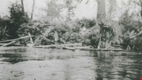
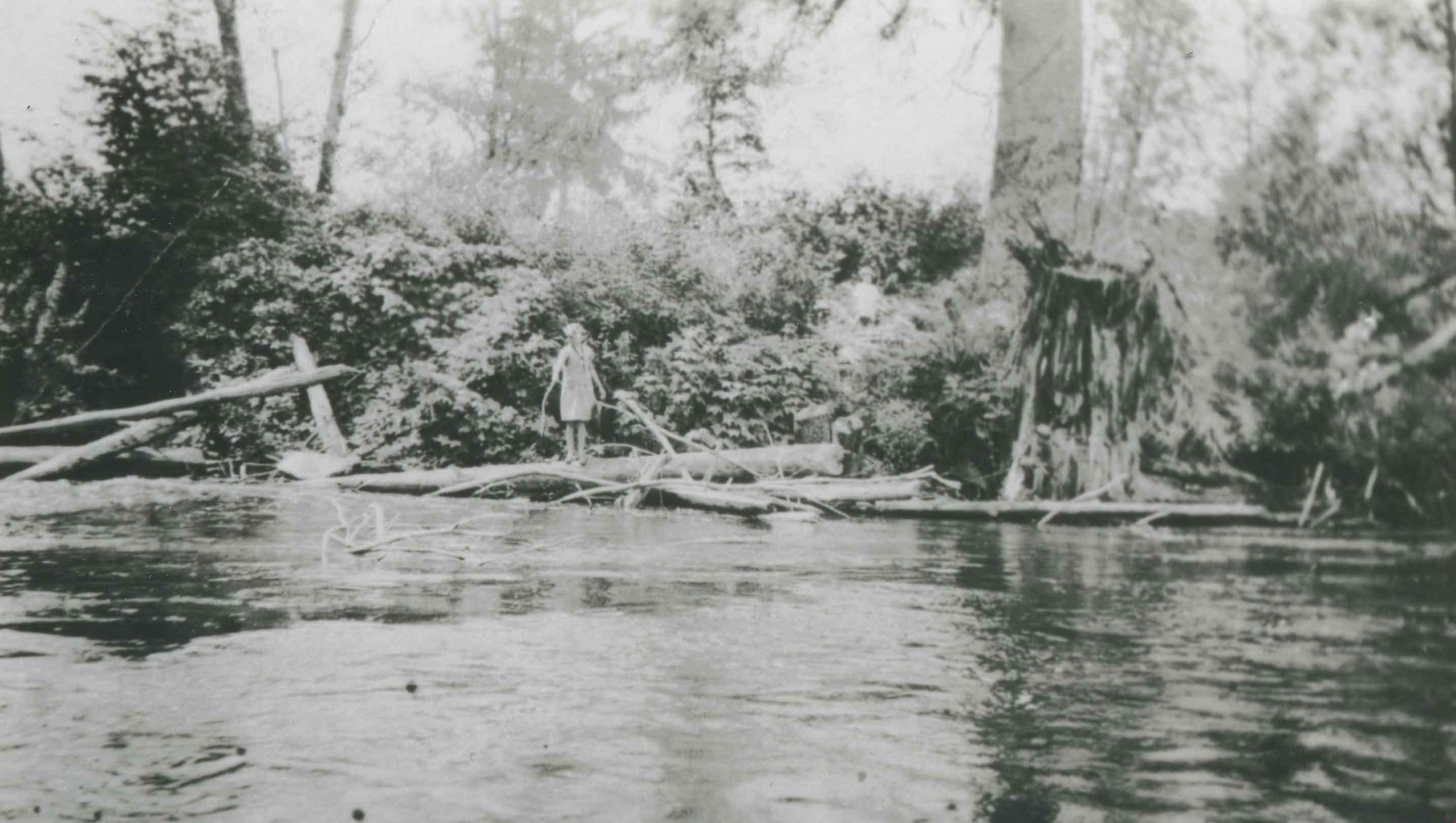
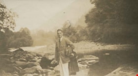
Fraser River
https://search.heritageburnaby.ca/link/archivedescription37077
- Repository
- City of Burnaby Archives
- Date
- 1920 (date of original), copied 1992
- Collection/Fonds
- Burnaby Historical Society fonds
- Description Level
- Item
- Physical Description
- 1 photograph : b&w ; 7.1 x 12.3 cm print
- Scope and Content
- Photograph of the Fraser River shore. A woman can be seen standing on a log on the river's edge.
- Repository
- City of Burnaby Archives
- Date
- 1920 (date of original), copied 1992
- Collection/Fonds
- Burnaby Historical Society fonds
- Subseries
- Burnaby Centennial Anthology subseries
- Physical Description
- 1 photograph : b&w ; 7.1 x 12.3 cm print
- Description Level
- Item
- Record No.
- 315-540
- Access Restriction
- No restrictions
- Reproduction Restriction
- No known restrictions
- Accession Number
- BHS1994-04
- Scope and Content
- Photograph of the Fraser River shore. A woman can be seen standing on a log on the river's edge.
- Subjects
- Geographic Features - Rivers
- Media Type
- Photograph
- Notes
- Title based on contents of photograph
- Historic Neighbourhood
- Fraser Arm (Historic Neighbourhood)
- Planning Study Area
- Big Bend Area
Images
Indian River
https://search.heritageburnaby.ca/link/archivedescription39238
- Repository
- City of Burnaby Archives
- Date
- 1923
- Collection/Fonds
- Peers Family and Hill Family fonds
- Description Level
- Item
- Physical Description
- 1 photograph : sepia ; 6 x 10.4 cm on page 24.5 x 32.5 cm (pasted in album)
- Scope and Content
- Photograph of Bob Peers standing on the bank of the Indian River.
- Repository
- City of Burnaby Archives
- Date
- 1923
- Collection/Fonds
- Peers Family and Hill Family fonds
- Physical Description
- 1 photograph : sepia ; 6 x 10.4 cm on page 24.5 x 32.5 cm (pasted in album)
- Description Level
- Item
- Record No.
- 477-557
- Access Restriction
- No restrictions
- Reproduction Restriction
- No known restrictions
- Accession Number
- 2007-12
- Scope and Content
- Photograph of Bob Peers standing on the bank of the Indian River.
- Subjects
- Geographic Features - Rivers
- Media Type
- Photograph
- Notes
- Title based on caption accompanying photograph
Images

![Tony Fabian relaxing at a picnic table, [1970]. Item no. 549-026. thumbnail](/media/hpo/_Data/_Archives_Images/_Unrestricted/540/549-026.jpg?width=280)
Interview with Tony Fabian by Eric Damer October 10, 2012 - Track 5
https://search.heritageburnaby.ca/link/oralhistory326
- Repository
- City of Burnaby Archives
- Date Range
- 1971-2012
- Length
- 0:09:30
- Summary
- This portion of the recording pertains to Tony Fabian's memories of the development of the Fraser River Foreshore and the Confederation Community Centre (previously named Confederation House).
- Repository
- City of Burnaby Archives
- Summary
- This portion of the recording pertains to Tony Fabian's memories of the development of the Fraser River Foreshore and the Confederation Community Centre (previously named Confederation House).
- Date Range
- 1971-2012
- Photo Info
- Tony Fabian relaxing at a picnic table, [1970]. Item no. 549-026.
- Length
- 0:09:30
- Interviewer
- Damer, Eric
- Interview Date
- October 10, 2012
- Scope and Content
- Recording is an interview with Tony Fabian conducted by Burnaby Village Museum employee Eric Damer, October 10, 2012. Major theme discussed: environmental conservation practices in Burnaby.
- Biographical Notes
- Tony Fabian was born and raised in rural Saskatchewan in 1934. He and his wife moved to Burnaby in 1957, where he worked for the telephone company and raised a family. Tony has been an advocate for preservation of parklands and watercourses, helping to protect Burnaby and Deer Lake Parks and to create the Burnaby Fraser Foreshore and Barnet Marine Parks in the early nineteen-seventies, serving as a member of Burnaby’s Parks and Recreation Commission. Tony Fabian was presented with the 2008 City of Burnaby Environment Award for Community Stewardship.
- Total Tracks
- 5
- Total Length
- 0:47:48
- Interviewee Name
- Fabian, Tony
- Interview Location
- Burnaby Village Museum
- Interviewer Bio
- Eric Damer is a lifelong British Columbian born in Victoria, raised in Kamloops, and currently residing in Burnaby. After studying philosophy at the University of Victoria, he became interested in the educational forces that had shaped his own life. He completed master’s and doctoral degrees in educational studies at the University of British Columbia with a particular interest in the history of adult and higher education in the province. In 2012, Eric worked for the City of Burnaby as a field researcher and writer, conducting interviews for the City Archives and Museum Oral History Program.
- Collection/Fonds
- Community Heritage Commission Special Projects fonds
- Transcript Available
- None
- Media Type
- Sound Recording
Images
![Tony Fabian relaxing at a picnic table, [1970]. Item no. 549-026. thumbnail](/media/hpo/_Data/_Archives_Images/_Unrestricted/540/549-026.jpg)
Audio Tracks
Track five of recording of interview with Tony Fabian
Track five of recording of interview with Tony Fabian
https://search.heritageburnaby.ca/media/hpo/_Data/_Archives_Oral_Histories/_Unrestricted/MSS171-009/MSS171-009_Track_5.mp3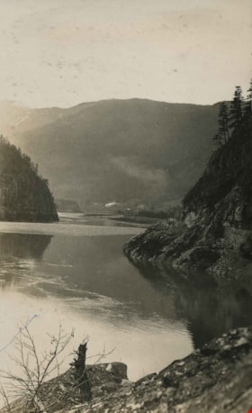
Looking down river
https://search.heritageburnaby.ca/link/archivedescription34474
- Repository
- City of Burnaby Archives
- Date
- 1925
- Collection/Fonds
- Burnaby Historical Society fonds
- Description Level
- Item
- Physical Description
- 1 photograph : b&w ; 7 x 11.5 cm on page 17.5 x 26.3 cm
- Scope and Content
- Photograph taken looking down the river at Yale. Mountains flank the shoreline and railway tracks and power poles can be seen to the right. This photograph appears to have been taken by Arthur Peers, who travelled through the Fraser River Valley and worked on the construction of the Trans-Provincia…
- Repository
- City of Burnaby Archives
- Date
- 1925
- Collection/Fonds
- Burnaby Historical Society fonds
- Subseries
- Peers family subseries
- Physical Description
- 1 photograph : b&w ; 7 x 11.5 cm on page 17.5 x 26.3 cm
- Description Level
- Item
- Record No.
- 020-181
- Access Restriction
- No restrictions
- Reproduction Restriction
- No known restrictions
- Accession Number
- BHS2007-04
- Scope and Content
- Photograph taken looking down the river at Yale. Mountains flank the shoreline and railway tracks and power poles can be seen to the right. This photograph appears to have been taken by Arthur Peers, who travelled through the Fraser River Valley and worked on the construction of the Trans-Provincial Highway during the later 1920s. A caption accompanying the photograph reads: "Looking down River from Road Near 2nd Tunnel."
- Subjects
- Geographic Features - Rivers
- Media Type
- Photograph
- Photographer
- Peers, Arthur Francis "Mike"
- Notes
- Title based on caption accompanying photograph
Images


Looking down river from the dykes
https://search.heritageburnaby.ca/link/archivedescription34399
- Repository
- City of Burnaby Archives
- Date
- 1926
- Collection/Fonds
- Burnaby Historical Society fonds
- Description Level
- Item
- Physical Description
- 1 photograph : b&w ; 7 x 10.7 cm on page 17.5 x 26.5 cm
- Scope and Content
- Photograph of an unidentified river at the foot of the mountains with railroad tracks in the foregound. Snow is covering the ground. This photograph appears to have been taken by Arthur Peers, who travelled through the Fraser River Valley and worked on the construction of the Trans-Provincial Highw…
- Repository
- City of Burnaby Archives
- Date
- 1926
- Collection/Fonds
- Burnaby Historical Society fonds
- Subseries
- Peers family subseries
- Physical Description
- 1 photograph : b&w ; 7 x 10.7 cm on page 17.5 x 26.5 cm
- Description Level
- Item
- Record No.
- 020-106
- Access Restriction
- No restrictions
- Reproduction Restriction
- No known restrictions
- Accession Number
- BHS2007-04
- Scope and Content
- Photograph of an unidentified river at the foot of the mountains with railroad tracks in the foregound. Snow is covering the ground. This photograph appears to have been taken by Arthur Peers, who travelled through the Fraser River Valley and worked on the construction of the Trans-Provincial Highway during the later 1920s.
- Media Type
- Photograph
- Photographer
- Peers, Arthur Francis "Mike"
- Notes
- Title based on caption accompanying photograph
Images

![Looking downstream, [1927] thumbnail](/media/hpo/_Data/_Archives_Images/_Unrestricted/001/020-145.jpg?width=280)
Looking downstream
https://search.heritageburnaby.ca/link/archivedescription34438
- Repository
- City of Burnaby Archives
- Date
- [1927]
- Collection/Fonds
- Burnaby Historical Society fonds
- Description Level
- Item
- Physical Description
- 1 photograph : b&w ; 7 x 12.2 cm on page 17.5 x 26 cm
- Scope and Content
- Photograph taken looking downstream, at Pretty's Creek.
- Repository
- City of Burnaby Archives
- Date
- [1927]
- Collection/Fonds
- Burnaby Historical Society fonds
- Subseries
- Peers family subseries
- Physical Description
- 1 photograph : b&w ; 7 x 12.2 cm on page 17.5 x 26 cm
- Description Level
- Item
- Record No.
- 020-145
- Access Restriction
- No restrictions
- Reproduction Restriction
- No known restrictions
- Accession Number
- BHS2007-04
- Scope and Content
- Photograph taken looking downstream, at Pretty's Creek.
- Subjects
- Geographic Features - Rivers
- Media Type
- Photograph
- Notes
- Title based on caption accompanying photograph
Images
![Looking downstream, [1927] thumbnail](/media/hpo/_Data/_Archives_Images/_Unrestricted/001/020-145.jpg)