Narrow Results By
Burnaby North High School
https://search.heritageburnaby.ca/link/landmark745
- Repository
- Burnaby Heritage Planning
- Associated Dates
- 1923-1982
- Street View URL
- Google Maps Street View
- Repository
- Burnaby Heritage Planning
- Geographic Access
- Willingdon Avenue
- Associated Dates
- 1923-1982
- Heritage Value
- Burnaby North and Burnaby South were the first high schools built in the City. Before the high school opened, Burnaby students had to travel to Vancouver if they wished to pursue education beyond an elementary level. In 1921, arrangements were made to use the basement of the Presbyterian Church for instruction of local students. By 1922 the Burnaby North High School opened at its first permanent location (4375 Pandora Street - which is now Rosser Elementary). In 1945, the Willingdon Avenue site was built and was used until a new building was constructed in 1961 on Hammarskjold Drive. From 1962, the school was used as Burnaby Heights Junior High school, but it closed in 1982 and the junior high students went to the new Burnaby North on Hammarskjold.
- Historic Neighbourhood
- Capitol Hill (Historic Neighbourhood)
- Planning Study Area
- Capitol Hill Area
- Street Address
- 250 Willingdon Avenue
- Street View URL
- Google Maps Street View
Images
Capitol Hill Neighbourhood
https://search.heritageburnaby.ca/link/landmark742
- Repository
- Burnaby Heritage Planning
- Associated Dates
- 1905-1924
- Heritage Value
- Real estate ventures became quite active in the Vancouver Heights and Capitol Hill areas of Burnaby by 1908. Brokerage firms and agents who bought large tracts, subdivided and sold them off in parcels and by 1909 had adopted the name "Capitol Hill" to describe Burnaby's newest neighbourhood. In his book, History of Burnaby and Vicinity," historian George Green explains that the term "Capitol Hill" was taken from ancient Rome where the civic centre was built upon the Capitoline Hill, one of the seven hills of the eternal city. In 1909, the Scott Brokerage Company advertised the sale of lots on Capitol Hill, calling it "one of Vancouver's swellest suburbs."
- Historic Neighbourhood
- Capitol Hill (Historic Neighbourhood)
- Planning Study Area
- Capitol Hill Area
Images
Capitol Hill Neighbourhood
https://search.heritageburnaby.ca/link/landmark781
- Repository
- Burnaby Heritage Planning
- Associated Dates
- 1955-2008
- Heritage Value
- The Capitol Hill Neighbourhood remained a primarily residential neighbourhood after the population boom of the 1950s and 1960s. The commercial focus remained the Hastings Street corridor, while the City of Burnaby moved to protect a conservation area on the north side of Capitol Hill and dedicated parkland throughout the 1970s and 1980s.
- Historic Neighbourhood
- Capitol Hill (Historic Neighbourhood)
- Planning Study Area
- Capitol Hill Area
Images
Confederation Park Elementary School
https://search.heritageburnaby.ca/link/landmark786
- Repository
- Burnaby Heritage Planning
- Geographic Access
- Pandora Street
- Associated Dates
- 1965
- Heritage Value
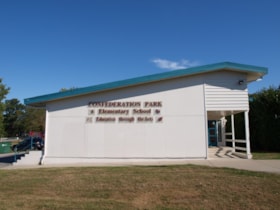
- Confederation Park school was built in 1965 to alleviate increased enrolments in Rosser Avenue and Capitol Hill schools. All elementary schools built in Burnaby in the post-war period share similar features and Confederation Park is no exception. Built low to the ground with no basement, no second stories and no high stairways, the structures could be easily added to as needed as the classrooms were built in a line.
- Historic Neighbourhood
- Capitol Hill (Historic Neighbourhood)
- Planning Study Area
- Capitol Hill Area
- Street Address
- 4715 Pandora Street
- Street View URL
- Google Maps Street View


