Narrow Results By
Creator
- Burnaby Village Museum 2
- Draper, William Nelson 1
- Fortney, Sharon 1
- Hill, Albert James 3
- Kwantlen First Nation 1
- Luxton, Donald, 1954- 1
- ʷməθkʷəy̓əm (Musqueam) First Nation 1
- Riverway West School Parent-Teachers Association 1
- Seaforth School 1
- Sḵwx̱wú7mesh First Nation 1
- Tsleil-Waututh First Nation 1
- Wilcox, R. Turner (Ruth Turner), 1888-1970 1

Aliceville
https://search.heritageburnaby.ca/link/landmark721
- Repository
- Burnaby Heritage Planning
- Associated Dates
- 1886
- Heritage Value
- Shortly after the townsite of Port Moody was surveyed in the early 1880s, a resort community developed on the border of Burnaby and Port Moody that would come to be called Aliceville. Located near the north end of North Road, in 1886 the Canadian Pacific Railway established a flag station there and the settlement was named after Alice May Webster who, with her sister Mrs. Jenns, operated the Aliceville Hotel.
- Historic Neighbourhood
- Barnet (Historic Neighbourhood)
- Planning Study Area
- Burnaby Mountain Area
Images


History of Burnaby Resource Guide
https://search.heritageburnaby.ca/link/museumlibrary7492
- Repository
- Burnaby Village Museum
- Author
- Burnaby Village Museum
- Publication Date
- 2019
of land, and become the “owners” of
that land by clearing trees and building homes.
Dispossession meant taking control of land and resources forcibly
from Indigenous people. The Royal Engineers assisted this process as
a military presence, and by surveying and building wagon roads and
town sites that
- Repository
- Burnaby Village Museum
- Collection
- Digital Reference Collection
- Material Type
- Digital Resource
- Accession Code
- BV019.63.1
- Author
- Burnaby Village Museum
- Place of Publication
- Burnaby, BC
- Publisher
- City of Burnaby
- Publication Date
- 2019
- Physical Description
- 21 p. : ill.
- Library Subject (LOC)
- Burnaby (B.C.)--History
- Directories
- Object History
- Created from research gathered by Burnaby Village Museum staff into the diverse History of Burnaby.
Images

Digital Books
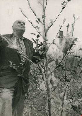
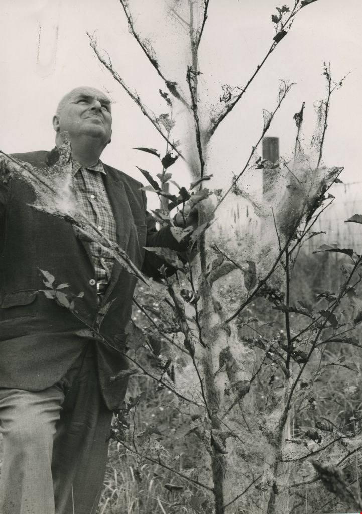
William Hawley surveys tree destruction
https://search.heritageburnaby.ca/link/archivedescription45198
- Repository
- City of Burnaby Archives
- Date
- 1962, published September 8, 1962
- Collection/Fonds
- Columbian Newspaper collection
- Description Level
- Item
- Physical Description
- 1 photograph : b&w ; 20 x 14 cm
- Scope and Content
- Photograph of Columbian farm and garden columnist William Hawley surveying tree destruction caused by tent caterpillars. He was the garden columnist for most of the 1960's, and prior to that he was a salesman and nutritionist for Brackman-Kerr feed store in New Westminster for 40 years. He and his …
- Repository
- City of Burnaby Archives
- Date
- 1962, published September 8, 1962
- Collection/Fonds
- Columbian Newspaper collection
- Physical Description
- 1 photograph : b&w ; 20 x 14 cm
- Description Level
- Item
- Record No.
- 480-094
- Access Restriction
- No restrictions
- Reproduction Restriction
- Reproduce for fair dealing purposes only
- Accession Number
- 2003-02
- Scope and Content
- Photograph of Columbian farm and garden columnist William Hawley surveying tree destruction caused by tent caterpillars. He was the garden columnist for most of the 1960's, and prior to that he was a salesman and nutritionist for Brackman-Kerr feed store in New Westminster for 40 years. He and his wife Doreen were married for 52 years.
- Subjects
- Occupations - Journalists
- Plants - Trees
- Media Type
- Photograph
- Notes
- Title based on contents of photograph
Images
![Survey and Subdivision plans in New Westminster District Group 1 – Burnaby, Port Moody, [1862-1908] thumbnail](/media/hpo/_Data/_BVM_Cartographic_Material/1977/1977_0093_0026a_001.jpg?width=280)
Survey and Subdivision plans in New Westminster District Group 1 – Burnaby, Port Moody
https://search.heritageburnaby.ca/link/museumdescription6995
- Repository
- Burnaby Village Museum
- Date
- [1862-1908]
- Collection/Fonds
- Burnaby Village Museum Map collection
- Description Level
- File
- Physical Description
- 9 plans : 6 plans : black ink on paper ; 57 x 36.5 cm or smaller + 1 plan : black ink and grahite on paper ; 46.5 x 49 cm + 1 plan : blueprint on paper ; 15.5 x 19.5 cm + cm + 1 plan : graphite on paper ; 25 x 17 cm ; mounted on both sides of board 76 x 102 cm
- Scope and Content
- Item consists of a large board of four New Westminster District subdivision plans mounted on one side and five New Westminster District subdivision plans mounted on the other side. Side A: 1. "Plan / of Subdivision / of a Portion / of / Lot 87 / Group One / New Westminster District / Scale 4 chs…
- Repository
- Burnaby Village Museum
- Collection/Fonds
- Burnaby Village Museum Map collection
- Description Level
- File
- Physical Description
- 9 plans : 6 plans : black ink on paper ; 57 x 36.5 cm or smaller + 1 plan : black ink and grahite on paper ; 46.5 x 49 cm + 1 plan : blueprint on paper ; 15.5 x 19.5 cm + cm + 1 plan : graphite on paper ; 25 x 17 cm ; mounted on both sides of board 76 x 102 cm
- Material Details
- Scales [between 1:792 and 1:3600]
- Index number on edge of board reads: "26"
- Scope and Content
- Item consists of a large board of four New Westminster District subdivision plans mounted on one side and five New Westminster District subdivision plans mounted on the other side. Side A: 1. "Plan / of Subdivision / of a Portion / of / Lot 87 / Group One / New Westminster District / Scale 4 chs = 1 in". Plan is stamped: "Albert J. Hill, Civil Engineer / and / Provincial Land Surveyor, / New Westminster, / B.C." and intialed by: "RB" [sic] (in blue pencil crayon). Names two of the subdivisons of District Lot 87 are identified as, "L.E. Sprott" and "John Ledger". (Geographic location: Burnaby) 2. "Plan of Subdivision / of / Portions of / Lot 136, 131 and Lots 44 and 78 Gr.1 / New Westminster District / Scale 300 ft = 1 inch". Annotation above title reads: "No. 901 / Deposited in Land Registry Office / New Westminster / Aug. 19th 1905 / Charles S. Keith D. Reg." Annotations and signatures at bottom of plan read: "I, William Nelson Draper, / W.H.R. Collister / Charles E. Perkins / E.B. Morgan / make / Surveys / correct / representation / upon / the / Land Registry Act / (sgd) W.N. Draper, P.L.S.". Plan includes a handwritten title: "Lots 136, 131, 44 & 78" and is initialed: "RB" [sic] (in blue pencil crayon) (Geographic location: Burnaby) 3. "Survey / of / a Portion / of / Lot 95, Gr.1 / Scale 1 ch = 1in." Plan is stamped: "Albert J. Hill, Civil Engineer / and / Provincial Land Surveyor, / New Westminster, / B.C." and is initialed : "RB" [sic] (in blue pencil crayon) (Geographic location: Burnaby) 4. Blueprint plan of "Lot 396. Group One." with Scale : 3 chs = 1 in. A two acre portion of District Lot 396 is filled in with red ink." Plan is signed by "Albert J. Hill / B.C.L.S." (Geographic location: Port Moody) Side B: 1. Plan titled "District Lot 92 / Burnaby / Municipality / for sale by / Mahon / McFarland & / Mahon Ltd. / Vancouver, B.C. / Scale : 4 chains to one inch". District Lot 92 is subdivided into 161 lots and identifies roads: Norwich Road, Pole Line Road, Oakland Road, Stanley Road, Burford Road, Dalhousie Road, Brantford Road, Colborne Road, Roberts Road, Vancouver & Westminster Road, B.C. Electric Railway, Gilley Stn. and Burnaby (Power House). The bottom of the plan reads: "G.S. Dawson, P.LS. Vancouver, B.C." (Geographic location: Burnaby) 2. "Plan / of Subdivision / of a Portion / of / Lot 29 / Group 1 / New Westminster District / Scale 2 chs = 1 in". Plan is stamped: "Albert J. Hill, Civil Engineer / and / Provincial Land Surveyor, / New Westminster, / B.C." and is initialed by: "RB" [sic] (in blue pencil crayon) (Geographic location: Burnaby) 3. Small handrawn plan (no title) identifying "Lot 84 / Hydes, Claim" at the centre surrounded by lots and features identified as: "Lot 85", "Lot 93", "Lot 94", "Lot 32", "Lot 82", "Lot 83", "Lot 79", "swamp" and a "Small Lake" (Burnaby Lake). Identifying marks in the right corner of the plan read: "Page 13 / Surveyed by G. Turner / May 62". Plan also includes surveyor's bearing measurements and trails to "Small Lake" (Burnaby Lake). (Geographic location: Burnaby) 4. Untitled plan showing District Lots west of North Road and north of Burnaby Lake including: Lots 2, 4, 6, 8, 15, 10, 56, 148, 57, 58, 40. and Lots 3, 5, 7 east of North Road (Coquitlam). Lots in Burnaby are identifed for timber including: "Heavily Timbered" (Lot 57), " "Some Fir and Cedar" (Lot 40), "Splendid Fir and Cedar" (Lot 143), "Heavy Fir etc" (Lots 143 and 148), " "Fine Cedar" (Lot 15), "Rough Light Timber" (Lot 56). Other features identified at the lower portion of the plan include "Burnaby Lake" and "Brunette River". (Geographic location: Burnaby) 5. Untitled plan drawn in graphite showing sections of District Lot 85 south of Burnaby Lake and north of Hazsard Road. Plan is signed: "Albert J. Hill / B.C.L.S." and dated "12/26/08". Plan is initialed by: "RB" [sic] (in blue pencil crayon) (Geographic location: Burnaby)
- Publisher
- Mahon, McFarland & Mahon Ltd
- Accession Code
- HV977.93.26
- Access Restriction
- No restrictions
- Reproduction Restriction
- No known restrictions
- Date
- [1862-1908]
- Media Type
- Cartographic Material
- Historic Neighbourhood
- Burnaby Lake (Historic Neighbourhood)
- Burquitlam (Historic Neighbourhood)
- Planning Study Area
- Burnaby Lake Area
- Scan Resolution
- 300
- Scale
- 72
- Notes
- Title based on contents of file
- Scale is measured in chains and feet. (One chain equals 792 inches)
- The term "Lot" can also refer to a "District Lot”
Images
![Survey and Subdivision plans in New Westminster District Group 1 – Burnaby, Port Moody, [1862-1908] thumbnail](/media/hpo/_Data/_BVM_Cartographic_Material/1977/1977_0093_0026a_001.jpg)


Burnaby's heritage : an inventory of buildings and structures
https://search.heritageburnaby.ca/link/museumlibrary5437
- Repository
- Burnaby Village Museum
- Author
- Luxton, Donald, 1954-
- Wolf, Jim
- Edition
- Rev.
- Publication Date
- 2011
- c2007
- Call Number
- 971.133 LUX COPY 1
- Repository
- Burnaby Village Museum
- Collection
- Digital Reference Collection
- Material Type
- Book
- ISBN
- 0969282893
- Call Number
- 971.133 LUX COPY 1
- Edition
- Rev.
- Author
- Luxton, Donald, 1954-
- Wolf, Jim
- Place of Publication
- Burnaby, B.C.
- Publisher
- City of Burnaby
- Publication Date
- 2011
- c2007
- Physical Description
- 157 p. : ill. ; 28 cm.
- Library Subject (LOC)
- Architecture
- Historic buildings
- Buildings
- Historic sites
- Subjects
- Buildings
- Buildings - Heritage
- Notes
- Includes bibliographical references and index.
- 2 copies held: copy 1.
Digital Books
Municipal survey / Horace L. Brittain
https://search.heritageburnaby.ca/link/archivedescription1689
- Repository
- City of Burnaby Archives
- Date
- 1932-1962
- Collection/Fonds
- City Council and Office of the City Clerk fonds
- Description Level
- File
- Physical Description
- Textual record
- Scope and Content
- File includes records regarding a "municipal survey" by Horace L. Brittain
- Repository
- City of Burnaby Archives
- Date
- 1932-1962
- Collection/Fonds
- City Council and Office of the City Clerk fonds
- Physical Description
- Textual record
- Description Level
- File
- Record No.
- 3509
- Accession Number
- 2001-02
- Scope and Content
- File includes records regarding a "municipal survey" by Horace L. Brittain
- Media Type
- Textual Record
![Survey and Subdivision plans in New Westminster District Group 1 – Burnaby
, [1861]-[1910] thumbnail](/media/hpo/_Data/_BVM_Cartographic_Material/1977/1977_0093_0019a_001.jpg?width=280)
Survey and Subdivision plans in New Westminster District Group 1 – Burnaby
https://search.heritageburnaby.ca/link/museumdescription6988
- Repository
- Burnaby Village Museum
- Date
- [1861]-[1910]
- Collection/Fonds
- Burnaby Village Museum Map collection
- Description Level
- File
- Physical Description
- 14 plans : 3 plans : black ink on paper hand col. + 7 plans : black ink on paper + 4 plans : graphite on paper mounted on 2 sides of cardboard 76 x 102 cm
- Scope and Content
- Item consists of a large board of four New Westminster District Gp 1 - subdivision plans mounted on one side and ten New Westminster District Gp 1 - subdivision plans mounted on the other side. Side A: 1. "Plan /of / Lots 166A, 166 and 167 /, Gr.1, N.W.D. / Showing Misconstructed Roads in Gree…
- Repository
- Burnaby Village Museum
- Collection/Fonds
- Burnaby Village Museum Map collection
- Description Level
- File
- Physical Description
- 14 plans : 3 plans : black ink on paper hand col. + 7 plans : black ink on paper + 4 plans : graphite on paper mounted on 2 sides of cardboard 76 x 102 cm
- Material Details
- Scales [between 1:2376 and 1:7920]
- Index number on edge of board reads: "19"
- Scope and Content
- Item consists of a large board of four New Westminster District Gp 1 - subdivision plans mounted on one side and ten New Westminster District Gp 1 - subdivision plans mounted on the other side. Side A: 1. "Plan /of / Lots 166A, 166 and 167 /, Gr.1, N.W.D. / Showing Misconstructed Roads in Green / 5 chs = 1 in.". (plan is drawn in black ink and hand coloured in red, green and orange ink). A section in the centre of the plan is coloured in red ink and identified as "C.S. Richmond" running from the North Arm of Fraser River to Wiggins Road and divided by "New Wiggins Rd. (as gazetted)" (coloured in orange ink) and two"Constructed Road(s)" (coloured in green ink). Plan is initialed by: "RB" [sic] (in blue pencil crayon) 2. Plan of / Subdivision of / Lot 166 / Group One / New Westminster District / Scale 4 chs = 1 in. / Map No 524". Plan is drawn in graphite and signed by "Surrig [sic] Welhams [sic] / P.L.S." Plan is initialed by: "RB" [sic] (in blue pencil crayon) 3. Plan of "Survey / of Highway / For / Burnaby Council / in / Lots 13 _14 / Group One / Scale 4 chs = 1 in." Signed by "Albert J. Hill, P.L.S." Caribou Street and Caribou Road run through the centre of the plan. Plan is stamped: "Albert J. Hill, Civil Engineer / and / Provincial Land Surveyor, / New Westminster, / B.C.". Plan is initialed by: "RB" [sic] (in blue pencil crayon) 4. A Plan of Lots 166A, 166 and 167, Group One, New Westminster District (drawn in graphite). A section in the centre of the plan is identified as "C.S. Richmond" running from the North Arm of Fraser River and divided by "New Wiggins Rd. (as gazetted)" and two "Constructed Road(s)". Plan is initialed by: "RB" [sic] (in blue pencil crayon) Side B: 1. Small plan drawn in black ink (no title) identifying lots north of the "North Arm" of the Fraser River. Lots identified include: Lot 99, Lot 98, Lot 157, Lot 158, Lot 163, Lot 162, Lot 159, Lot 163, Lot 162, Lot 165, Lot 166A, Lot 155B, Lot 155A and Lot 159. "Scale 40 chains to one inch" . Plan is initialed by: "RB" [sic] (in blue pencil crayon) (Geographic location: Burnaby) 2. Small plan drawn in black ink (no title) identifying lots north of the North Arm of the Fraser River as "Lots 155, 155A, 155B, 155C, 162, 163, 164, 165, 166A and 167". Plan is initialed by: "RB" [sic] (in blue pencil crayon) (Geographic location: Burnaby) 3. Small plan drawn in black ink (no title) which identifies "Lot 151 / Reserve/ for / Race Course"; "Reserve / 64 A / L. 152 G.1"; and other Lots: 32, 33, 34, 35, 36, 38, 39. The plan is signed "Surveyor G.Turn [sic] July / 61 / from Vol 40 R.L. notes [sic]" Plan is stamped: "Albert J. Hill, Civil Engineer / and / Provincial Land Surveyor, / New Westminster, / B.C." Plan is initialed by: "RB" [sic] (in blue pencil crayon) (Geographic location: Burnaby) 4. Small plan drawn in black in with faded red colouring on centre lot identified as "Lot 34" running north from "Vancouver Road" . Plan is stamped: "Albert J. Hill, Civil Engineer / and / Provincial Land Surveyor, / New Westminster, / B.C." Plan is initialed by: "RB" [sic] (in blue pencil crayon) (Geographic location: Burnaby) 5. Plan drawn in graphite and identified as "Lot 98, Gr.1," along with the intials "RB" [sic] (both are handwritten in blue crayon pencil on top of plan) The B.C.E.Railway is identified running through the plan along with Jubilee Road and Royal Oak Road. The plan is signed with the name "Wm. Murray" and the Plan is stamped: "Albert J. Hill, Civil Engineer / and / Provincial Land Surveyor, / New Westminster, / B.C.". (Geographic location: Burnaby) 6. Plan drawn in graphite identified as "Port Lot 13, Gr.1" along with the intials "RB" [sic] (both are handwritten in blue crayon pencil on top of plan) Plan is stamped: "Albert J. Hill, Civil Engineer / and / Provincial Land Surveyor, / New Westminster, / B.C.". (Geographic location: Burnaby) 7.Plan drawn in black ink and identified as "Lot 98 G.1" along with the intials "RB" [sic] (both are handwritten in blue crayon pencil on top of plan). A "Road Reservation" is identified running north between "Electric Tramway" and connecting with "Royal Oak Road". Plan is stamped: "Albert J. Hill, Civil Engineer / and / Provincial Land Surveyor, / New Westminster, / B.C." (Geographic location: Burnaby) 8. Plan drawn in black ink and divided into two sections, the upper plan is identified as "Portion / Lots 100 / area / 101, Gr.1" and the lower plan is identified as "Portion L. 3 G. 1" along with the intials "RB" [sic] (these identifiers are handwritten in blue crayon pencil on top of the plan). Portions of Lot 100 and Lot 101 are each divided into 6 sections and the Portion of Lot 3 plan is divided into 24 sections. The plan includes a note in black ink that reads: " Received from Wm Fromme [sic] / from Wm. Trapp / Nov. 28, 1895 / A. J. T...[sic]". (Geographic location: Burnaby) 9. Plan drawn in black ink (no title) identifying soil, buildings and geographic features in southern Burnaby. The plan is bordered by "New Westminster City" (Tenth Avenue and DL 172) to the south east and DL 173 to the south, DL 158 to the west and the B.C.E. Tramway to the north. Plan includes District Lots: 155A, 158, 159, 171, 160, 53 and 95 and identifies soil, marshland and ravines throughout. Plan identifies the following features: a "Team Road" running through Lots 158 and 159 along with "Fair Orchard Soil / Even Surface Throughout / No Ravines", "Gravel and Shingle" (bottom of Lot 158), "North Arm Road" crossing "Byrne Road" and connecting with "Power House Road" which runs north to connect with "Highland Park Station" and the B.C.E. Tramway, "Power Ho" in the northeast corner of DL 160, a "Brook" connected with a "Deep Ravine" running between DL 53, DL 95 and DL 160 along with "Good Soil" and "Fair Orchard Soil" identified nearby in DL 95. Scale is identified as "10 chs = 1 in." Plan is stamped: "Albert J. Hill, Civil Engineer / and / Provincial Land Surveyor, / New Westminster, / B.C." Plan is initialed by: "RB" [sic] (in blue pencil crayon) (Geographic location: Burnaby) 10. Plan drawn in black ink (no title) with Burnaby Lake and Deer Lake at the centre. The plan is bordered by the following District Lots identified as: 117, 118 and 68 to the west, Lots 80, 79 and 85 to the southwest, Lots 11, 13, and 1 (City of New Westminster) to the south east, the North Road boundary to the east and Lots 8, 56, 57, 59, and 136 to the North. The lower right hand corner of the plan has a small inset which reads: "Burnaby Lake" and "Page 19 R.B. Notes". Plan is initialed by: "RB" [sic] (in blue pencil crayon) (Geographic location: Burnaby)
- Creator
- Hill, Albert James
- Accession Code
- HV977.93.19
- Access Restriction
- No restrictions
- Reproduction Restriction
- No known restrictions
- Date
- [1861]-[1910]
- Media Type
- Cartographic Material
- Scan Resolution
- 300
- Scale
- 72
- Notes
- Title based on contents of file
- Scale is measured in chains. (One chain equals 792 inches)
- The term "Lot" can also refer to a "District Lot”
- Some plans are stamped: "Albert J. Hill, Civil Engineer / and / Provincial Land Surveyor, / New Westminster, / B.C." and intialed: "RB" [sic]
Images
![Survey and Subdivision plans in New Westminster District Group 1 – Burnaby
, [1861]-[1910] thumbnail](/media/hpo/_Data/_BVM_Cartographic_Material/1977/1977_0093_0019a_001.jpg)


Survey made by Albert J. Hill
https://search.heritageburnaby.ca/link/museumdescription11149
- Repository
- Burnaby Village Museum
- Date
- 1885
- Collection/Fonds
- Ronald G. Scobbie collection
- Description Level
- Item
- Physical Description
- 1 survey plan : blueprint ; 43 x 30 cm
- Scope and Content
- Item consists of a "Survey" / Made by Albert J. Hill" re the north boundary of district lots 9 and 107 on the east side of North Road.
- Repository
- Burnaby Village Museum
- Collection/Fonds
- Ronald G. Scobbie collection
- Description Level
- Item
- Physical Description
- 1 survey plan : blueprint ; 43 x 30 cm
- Scope and Content
- Item consists of a "Survey" / Made by Albert J. Hill" re the north boundary of district lots 9 and 107 on the east side of North Road.
- Creator
- Hill, Albert James
- Geographic Access
- North Road
- Accession Code
- BV003.83.28
- Access Restriction
- No restrictions
- Reproduction Restriction
- No known restrictions
- Date
- 1885
- Media Type
- Cartographic Material
- Scan Resolution
- 600
- Scan Date
- 15-Jan-2021
- Scale
- 100
- Notes
- Transcribed title
- Handwritten note pasted in upper right corner reads: "This is the blue print referred to in the letter" "dated. 13. December - 1910, sent by order of the Board to Messrs W.N. Draper & Albert J. Hill" "Re: North Boundary. Lots. 9 & 107." "New Westminster District" "Corp. B.C.L. Surveyors" "Victoria. B.C." "-- Roberts" "Sec Treas & Registrar"
- Note in pencil on verso reads: “North / Road”
- Note in red crayon on verso reads: “001607”
Images

Aerial photograph teaching aids
https://search.heritageburnaby.ca/link/archivedescription84879
- Repository
- City of Burnaby Archives
- Date
- 1960-1964
- Collection/Fonds
- Allan Amundsen collection
- Description Level
- File
- Physical Description
- 1 photograph : b&w (lasercopy) + 1 p. of textual records.
- Scope and Content
- File consists of one laser copy of an aerial photograph of Vancouver including Stanely Park, Downtown Vancouver and the North Shore and one B.C. Hydro Aerial Thermography Survey pamphlet. Both of these resources were used as teaching aids for a Geography 12 class at Burnaby North Secondary School.
- Repository
- City of Burnaby Archives
- Date
- 1960-1964
- Collection/Fonds
- Allan Amundsen collection
- Physical Description
- 1 photograph : b&w (lasercopy) + 1 p. of textual records.
- Description Level
- File
- Record No.
- MSS178-001
- Access Restriction
- In Archives only
- Reproduction Restriction
- No reproduction permitted
- Accession Number
- 2014-08
- Scope and Content
- File consists of one laser copy of an aerial photograph of Vancouver including Stanely Park, Downtown Vancouver and the North Shore and one B.C. Hydro Aerial Thermography Survey pamphlet. Both of these resources were used as teaching aids for a Geography 12 class at Burnaby North Secondary School.
- Media Type
- Textual Record
- Photograph
- Notes
- Title based on contents of file
Bylaw Number: 4316 - Special Survey Assessment Bylaw 1961
https://search.heritageburnaby.ca/link/bylaw20052
- Repository
- Legislative Services
- Bylaw Number
- 4316
- Final Adoption
- 1961 Dec 18
- Format
- Bylaws - Adopted
- Collection/Fonds
- City Council and Office of the City Clerk fonds
- Repository
- Legislative Services
- Bylaw Number
- 4316
- Final Adoption
- 1961 Dec 18
- Format
- Bylaws - Adopted
- Collection/Fonds
- City Council and Office of the City Clerk fonds
Documents
Bylaw Number: 4405 - Special Survey Assessment Bylaw 1962
https://search.heritageburnaby.ca/link/bylaw19963
- Repository
- Legislative Services
- Bylaw Number
- 4405
- Final Adoption
- 1962 Oct 15
- Format
- Bylaws - Adopted
- Collection/Fonds
- City Council and Office of the City Clerk fonds
- Repository
- Legislative Services
- Bylaw Number
- 4405
- Final Adoption
- 1962 Oct 15
- Format
- Bylaws - Adopted
- Collection/Fonds
- City Council and Office of the City Clerk fonds
Documents
Commerce and Industry series
https://search.heritageburnaby.ca/link/archivedescription168
- Repository
- City of Burnaby Archives
- Date
- 1951-1990
- Collection/Fonds
- Planning Department fonds
- Description Level
- Series
- Scope and Content
- Series consists of records related to the development of commercial and industrial sites in the City of Burnaby. These records include: maps, plans, architectural and technical material, reports, surveys, studies, applications, correspondence, and memoranda.
- Repository
- City of Burnaby Archives
- Date
- 1951-1990
- Collection/Fonds
- Planning Department fonds
- Series
- Commerce and Industry series
- Description Level
- Series
- Scope and Content
- Series consists of records related to the development of commercial and industrial sites in the City of Burnaby. These records include: maps, plans, architectural and technical material, reports, surveys, studies, applications, correspondence, and memoranda.
- Media Type
- Textual Record
Environmental Factors series
https://search.heritageburnaby.ca/link/archivedescription169
- Repository
- City of Burnaby Archives
- Date
- 1964-1989
- Collection/Fonds
- Planning Department fonds
- Description Level
- Series
- Scope and Content
- Series consists of those records that resulted from the work done by the Planning Department in the area of environmental monitoring and planning. This includes: reports, studies, minutes of Council and Council Committees, maps, plans, surveys, correspondence, and memoranda.
- Repository
- City of Burnaby Archives
- Date
- 1964-1989
- Collection/Fonds
- Planning Department fonds
- Series
- Environmental Factors series
- Description Level
- Series
- Scope and Content
- Series consists of those records that resulted from the work done by the Planning Department in the area of environmental monitoring and planning. This includes: reports, studies, minutes of Council and Council Committees, maps, plans, surveys, correspondence, and memoranda.
- Media Type
- Textual Record

Indigenous History in Burnaby Resource Guide
https://search.heritageburnaby.ca/link/museumlibrary7493
- Repository
- Burnaby Village Museum
- Collection
- Digital Reference Collection
- Material Type
- Digital Resource
- Accession Code
- BV019.64.1
- Call Number
- 971.100497 BVM
- Edition
- First
- Contributor
- Kwantlen First Nation
- Sḵwx̱wú7mesh First Nation
- Tsleil-Waututh First Nation
- ʷməθkʷəy̓əm (Musqueam) First Nation
- Place of Publication
- Burnaby, BC
- Publisher
- City of Burnaby
- Publication Date
- 2019
- Library Subject (LOC)
- Indigenous peoples--British Columbia
- Indigenous peoples--British Columbia--History
- Indigenous peoples--Canada--History
- Subjects
- Indigenous peoples - British Columbia
- Indigenous peoples - British Columbia - Languages
- Indigenous peoples - British Columbia - Societies, etc.
- Name Access
- Burnaby Village Museum
- Object History
- 2019 version of working document developed by Burnaby Village Museum in collaboration with a number of First Nations partners over the course of several years. We recognize that Burnaby falls within the shared, ancestral and unceded territories of the hən̓q̓əmin̓əm and Sḵwx̱wú7mesh speaking people. We equally respect each of the Nations who share territory in Burnaby, and invite and welcome their ongoing participation in developing the contents of the Indigenous History in Burnaby Resource Guide.
Images

Digital Books
Land Sales series
https://search.heritageburnaby.ca/link/archivedescription151
- Repository
- City of Burnaby Archives
- Date
- 1968-2003
- Collection/Fonds
- Legal Department fonds
- Description Level
- Series
- Scope and Content
- Series consists of records created during the land sale process coordinated by the City of Burnaby’s Legal Department. Records include: correspondence, memos, agreements, proposals, tenders, bids, reports, receipts for fees paid, registration of sale agreements, Land Title forms, surveys, appraisal…
- Repository
- City of Burnaby Archives
- Date
- 1968-2003
- Collection/Fonds
- Legal Department fonds
- Series
- Land Sales series
- Description Level
- Series
- Scope and Content
- Series consists of records created during the land sale process coordinated by the City of Burnaby’s Legal Department. Records include: correspondence, memos, agreements, proposals, tenders, bids, reports, receipts for fees paid, registration of sale agreements, Land Title forms, surveys, appraisals, estimates, legal opinions, as well as maps and other cartographic material.
- History
- In 2017, responsibility for City land sales was transferred to Realty and Lands.
- Media Type
- Textual Record
Love and Leonard land records series
https://search.heritageburnaby.ca/link/museumdescription18838
- Repository
- Burnaby Village Museum
- Date
- 1893-1962
- Collection/Fonds
- Love family fonds
- Description Level
- Series
- Physical Description
- 5 plans + 8 cm of textual records
- Scope and Content
- Series consists of land deeds, land sale agreements, documents regarding payment and survey and subdivision plans. Records refer to the Love family property in District Lot 25, the Leonard family property in District Lot 352 and other lots in Burnaby.
- Repository
- Burnaby Village Museum
- Collection/Fonds
- Love family fonds
- Description Level
- Series
- Physical Description
- 5 plans + 8 cm of textual records
- Scope and Content
- Series consists of land deeds, land sale agreements, documents regarding payment and survey and subdivision plans. Records refer to the Love family property in District Lot 25, the Leonard family property in District Lot 352 and other lots in Burnaby.
- Accession Code
- BV992.26
- BV012.31
- Date
- 1893-1962
- Media Type
- Textual Record
- Cartographic Material
- Notes
- Title based on contents of series
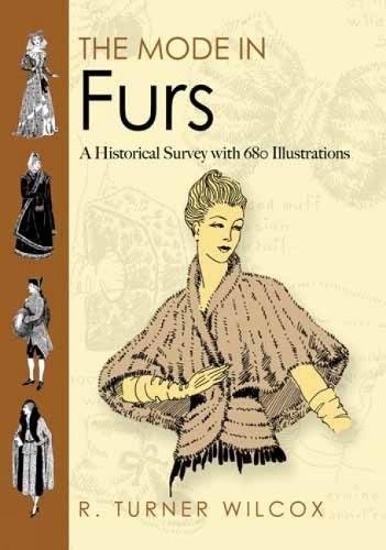
The mode in furs : a historical survey with 680 illustrations
https://search.heritageburnaby.ca/link/museumlibrary6059
- Repository
- Burnaby Village Museum
- Collection
- Reference collection
- Material Type
- Book
- ISBN
- 9780486478722
- 0486478726
- Call Number
- 391.009 WIL
- Place of Publication
- Mineola, New York
- Publisher
- Dover
- Publication Date
- 2010
- Physical Description
- xi, 257 p. : ill. ; 24 cm.
- Library Subject (LOC)
- Fur--History
- Clothing and dress
- Notes
- "This Dover ed. is an unabridged republication of the work originally published by Charles Scribner's Sons, New York, 1951, with the title The mode of furs : the history of furred costume of the world from the earliest times to the present."
- Includes bibliographical references
- Author's full name and dates: Wilcox, R. Turner (Ruth Turner), 1888-1970
Provincial Survey on Auxiliary Constable Program
https://search.heritageburnaby.ca/link/councilreport60698
- Repository
- City of Burnaby Archives
- Report ID
- 100999
- Meeting Date
- 9-May-2016
- Format
- Council - Manager's Report
- Item No.
- 5
- Collection/Fonds
- City Council and Office of the City Clerk fonds
- Repository
- City of Burnaby Archives
- Report ID
- 100999
- Meeting Date
- 9-May-2016
- Format
- Council - Manager's Report
- Item No.
- 5
- Collection/Fonds
- City Council and Office of the City Clerk fonds
Documents
Redevelopment and Urban Renewal series
https://search.heritageburnaby.ca/link/archivedescription183
- Repository
- City of Burnaby Archives
- Date
- 1931-1974
- Collection/Fonds
- Planning Department fonds
- Description Level
- Series
- Scope and Content
- Series contains records that resulted from the Planning Department’s participation in municipal redevelopment and urban renewal projects. The records include: maps, plans, surveys, reports, statistical information, studies, minutes of Council and Council Committees, correspondence, and memoranda.
- Media Type
- Textual Record
Renewal of Federal Gas Tax Agreement Union of BC Municipalities Member Survey
https://search.heritageburnaby.ca/link/councilreport59169
- Repository
- City of Burnaby Archives
- Report ID
- 99115
- Meeting Date
- 21-Oct-2013
- Format
- Council - Manager's Report
- Item No.
- 1
- Collection/Fonds
- City Council and Office of the City Clerk fonds
- Repository
- City of Burnaby Archives
- Report ID
- 99115
- Meeting Date
- 21-Oct-2013
- Format
- Council - Manager's Report
- Item No.
- 1
- Collection/Fonds
- City Council and Office of the City Clerk fonds