Narrow Results By
Decade
- 2020s 225
- 2010s
- 2000s 1824
- 1990s 2872
- 1980s
- 1970s 3517
- 1960s 1358
- 1950s 1712
- 1940s 2148
- 1930s 2158
- 1920s 2489
- 1910s 2036
- 1900s
- 1890s 250
- 1880s
- 1870s 72
- 1860s 123
- 1850s 14
- 1840s 5
- 1830s 3
- 1820s 2
- 1810s 3
- 1800s 3
- 1790s 2
- 1780s 2
- 1770s 2
- 1760s 2
- 1750s 2
- 1740s 2
- 1730s 2
- 1720s 2
- 1710s 2
- 1700s 2
- 1690s 2
- 1680s 2
- 1670s 1
- 1660s 1
- 1650s 1
- 1640s 1
- 1630s 1
- 1620s 1
- 1610s 1
- 1600s 1
- 1590s 1
- 1580s 1
- 1570s 1
- 1560s 1
- 1550s 1
- 1540s 1
- 1530s 1
- 1520s 2
- 1510s 1
- 1500s 1
- 1490s 1
- 1480s 1
Subject
- Accidents 1
- Adornment - Jewelry 1
- Advertising Medium 4
- Advertising Medium - Signs and Signboards 7
- Aerial Photographs 9
- Agricultural Tools and Equipment 10
- Agricultural Tools and Equipment - Gardening Equipment 1
- Agriculture - Beekeeping 3
- Agriculture - Crops 16
- Agriculture - Farms 29
- Agriculture - Fruit and Berries 16
- Agriculture - Orchards 1

West Central Valley Neighbourhood
https://search.heritageburnaby.ca/link/landmark778
- Repository
- Burnaby Heritage Planning
- Associated Dates
- 1955-2008
- Heritage Value
- The West Central Valley Neighbourhood is home to the Bridge Business Park and is a primarily industrial neighbourhood. Similar to the adjacent Dawson-Delta Neighbourhood, West Central Valley offers businesses convenient access to major roads and highways.
- Historic Neighbourhood
- Broadview (Historic Neighbourhood)
- Planning Study Area
- West Central Valley Area
Images


Westridge Neighbourhood
https://search.heritageburnaby.ca/link/landmark791
- Repository
- Burnaby Heritage Planning
- Associated Dates
- 1955-2008
- Heritage Value
- The Westridge Neighbourhood is effectively separated into two areas by Inlet Drive. To the west of the highway lies a typical 1950s subdivision of single-family homes, while to the east is a newer (1970s) subdivision featuring larger lots and some low-rise units. In the 1980 Residential Neighbourhood Environment Study, Westridge was characterised as a stable community with little need for direct Municipal involvement in growth and development.
- Historic Neighbourhood
- Lochdale (Historic Neighbourhood)
- Planning Study Area
- Westridge Area
Images


Willingdon Heights Neighbourhood
https://search.heritageburnaby.ca/link/landmark777
- Repository
- Burnaby Heritage Planning
- Associated Dates
- 1955-2008
- Heritage Value
- The convenient location of Willingdon Heights to the Trans Canada Highway, Lougheed Highway and Hastings Street has fostered its development as a primarily residential commuter neighbourhood. Characterised in the post-World War Two period by predominantly single-family developments, the neighbourhood has retained this identity despite some higher density apartment buildings now found there.
- Planning Study Area
- Willingdon Heights Area
Images


Windsor Neighbourhood
https://search.heritageburnaby.ca/link/landmark803
- Repository
- Burnaby Heritage Planning
- Associated Dates
- 1955-2008
- Heritage Value
- The Windsor Neighbourhood comprises a number of different districts with different characteristics. To the north, stretching to the border of the Deer Lake Park, is the primarily residential area that was developed after the building boom of the 1950s and now consists of a mix of single-family and multi-family housing. To the south, from Kingsway to the Skytrain line, an industrial area was maintained along with a significant commercial corridor along Kingsway. In recent years, the growth and development of this area has been guided by the Royal Oak Community Plan adopted by Council in 1999.
- Planning Study Area
- Windsor Area
Images


W.J. Walker House
https://search.heritageburnaby.ca/link/landmark548
- Repository
- Burnaby Heritage Planning
- Description
- The W.J. Walker House is a rustic cottage at the eastern end of Deer Lake and is now located within Deer Lake Park. It is a one-and-a-half-storey wood-frame shingle-clad vernacular structure.
- Associated Dates
- 1907
- Formal Recognition
- Heritage Designation, Community Heritage Register
- Other Names
- William & Olive Walker Residence
- Street View URL
- Google Maps Street View
- Repository
- Burnaby Heritage Planning
- Other Names
- William & Olive Walker Residence
- Geographic Access
- Sperling Avenue
- Associated Dates
- 1907
- Formal Recognition
- Heritage Designation, Community Heritage Register
- Enactment Type
- Bylaw No. 11593
- Enactment Date
- 15/09/2003
- Description
- The W.J. Walker House is a rustic cottage at the eastern end of Deer Lake and is now located within Deer Lake Park. It is a one-and-a-half-storey wood-frame shingle-clad vernacular structure.
- Heritage Value
- The W.J. Walker House is important as it references the economic activities in the Deer Lake area prior to the development of grand mansions in Deer Lake Park. It is typical of the cottages built by workers in the market gardening and lumber-milling industries that operated around the lake primarily from 1904-1925. This is the only cottage on the shores of Deer Lake remaining from the era when these industries were the focus of the area's development. The house demonstrates the aesthetic values of Olive Walker and her husband William J. Walker, a ‘rancher’ (market gardener, poultry farmer) who built the house as a retirement home, in the quality of its construction and interior finishing. The Craftsman styling of the house was a popular design vocabulary of the time and reflected the modern taste and values of the owner. The construction of the house also illustrates the use of locally milled lumber. The extant cold safe at the side of house is indicative of food storage methods in the early twentieth century and provides insight to the everyday domestic lives of people at this time.
- Defining Elements
- Key elements that define the heritage character of the W.J. Walker House include its: - location close to the lake and the site of the Deer Lake Lumber Company where the wood for construction of the house was milled - Craftsman style characteristics such as the house's orientation (front gable facing the street) and the combination of gable and double-pitched shed roofs - front entrance with its gabled porch supported by distinctive oversized diagonal brackets, and substantial front door of Douglas fir decorated with hand forged iron plates - cedar shingle siding - multiple-assembly wooden-sash casement windows with transoms - projecting cold safe - interior finishing that dates to the original construction of the house, such as the diagonally laid tongue-and-groove Douglas fir ceilings, wood panelled walls, and Clayburn brick fireplace
- Historic Neighbourhood
- Burnaby Lake (Historic Neighbourhood)
- Planning Study Area
- Morley-Buckingham Area
- Function
- Primary Current--Single Dwelling
- Primary Historic--Single Dwelling
- Community
- Burnaby
- Cadastral Identifier
- P.I.D. No. 017-105-773 Legal Description: Parcel 'A' (Reference Plan 3703), District Lot 85, Group 1, Except: Firstly: Parcel 'One' (Explanatory Plan 11350) Secondly: Parcel 2 (Reference Plan 35549) Group 1, New Westminster District.
- Boundaries
- The W.J. Walker House is comprised of a single municipally-owned property located at 5255 Sperling Avenue, Burnaby.
- Area
- 2,005.02
- Contributing Resource
- Building
- Landscape Feature
- Ownership
- Public (local)
- Documentation
- Heritage Site Files: PC77000 20. City of Burnaby Planning and Building Department, 4949 Canada Way, Burnaby, B.C., V5G 1M2
- Street Address
- 5255 Sperling Avenue
- Street View URL
- Google Maps Street View
Images


Woodward Cottage
https://search.heritageburnaby.ca/link/landmark496
- Repository
- Burnaby Heritage Planning
- Description
- Set far back from Sperling Avenue, Woodward Cottage is a one-storey, wood-frame house with a raised foundation and gabled roofline. It is located within a picturesque lakefront neighbourhood and is part of the Deer Lake Park Heritage Precinct.
- Associated Dates
- 1904
- Formal Recognition
- Community Heritage Register
- Other Names
- Maud & Harriet Woodward Cottage
- Street View URL
- Google Maps Street View
- Repository
- Burnaby Heritage Planning
- Other Names
- Maud & Harriet Woodward Cottage
- Geographic Access
- Sperling Avenue
- Associated Dates
- 1904
- Formal Recognition
- Community Heritage Register
- Enactment Type
- Council Resolution
- Enactment Date
- 26/05/2003
- Description
- Set far back from Sperling Avenue, Woodward Cottage is a one-storey, wood-frame house with a raised foundation and gabled roofline. It is located within a picturesque lakefront neighbourhood and is part of the Deer Lake Park Heritage Precinct.
- Heritage Value
- Woodward Cottage, built in 1904, is valued as the oldest house within the Deer Lake neighbourhood, whose construction marked the beginning of Deer Lake's transition from a rural farming community to a residential suburb. At the turn of the nineteenth century, Deer Lake was recognized for its tranquility and beautiful scenery, which, in turn, attracted New Westminster and Vancouver residents to relocate to the area and build family homes. The first owner, Maud Sarah Woodward (1865-1958), originally from England, was a pioneer nurse of Vancouver. In 1903, she purchased this property from her two close friends, Louis and Annie Hill, who were among Deer Lake's first residents. Maud and her sister, Harriet Julia Woodward (1879-1969), were prominent figures in the Deer Lake community and together they established the first post office in Burnaby, which operated out of this house. Due to the lack of any local facilities, in September 1904 Harriet Woodward established a private primary school here for the local children, which continued after 1908 as a kindergarten. The cottage was enlarged several times to accommodate the expanding post office until 1912, when the Woodwards began construction of a new, larger house. Woodward Cottage is also valued for its origins as an innovative prefabricated structure. In 1904, the B.C. Mills Timber and Trading Company patented a modular system in response to unprecedented population growth in the western provinces. This system could be adapted to provide everything from modest one-room cottages to schools, churches and banks. Short mill ends of lumber and siding, which had previously been discarded, were assembled into three or four-foot wide wall panels that could be bolted together. The vertical joints between the panels were covered by narrow battens, which gave these buildings their distinct appearance. The wall panels for the house were assembled at the mill, prepainted and packaged with various other components and the necessary instructions to assemble the building, and shipped via railway to its waiting customer. Woodward Cottage is one of the earliest surviving examples of this ingenious prefabricated system. In the 1930s, the cottage was raised and turned to allow for a new foundation to be built. Despite later additions and alterations, the original cottage form is still recognizable. Woodward Cottage is currently owned by the City of Burnaby and is part of the Deer Lake Park Heritage Precinct, Burnaby's most significant collection of historic sites.
- Defining Elements
- Key elements that define the heritage character of Woodward Cottage include its: - secluded lakefront site, set far back from Sperling Avenue, within the Deer Lake Park Heritage Precinct - residential form, scale and massing as expressed by its one-storey height and gabled roofline - original wood-frame construction and modular wall panels, extant under later stucco cladding - internal red-brick chimney - associated landscape features, including mature deciduous trees
- Historic Neighbourhood
- Burnaby Lake (Historic Neighbourhood)
- Planning Study Area
- Morley-Buckingham Area
- Organization
- Canadian Institute of Mining and Metallurgy
- Function
- Primary Historic--Single Dwelling
- Primary Current--Single Dwelling
- Community
- Deer Lake
- Cadastral Identifier
- P.I.D. 011-454-440
- Boundaries
- Woodward Cottage is comprised of a single residential lot located at 5141 Sperling Avenue, Burnaby.
- Area
- 6596
- Contributing Resource
- Building
- Ownership
- Public (local)
- Documentation
- City of Burnaby Planning and Building Department, Heritage Site Files
- Street Address
- 5141 Sperling Avenue
- Street View URL
- Google Maps Street View
Images


![1st Div 1907 West Burnaby School, [1907] thumbnail](/media/hpo/_Data/_BVM_Images/2012/2012_0020_0002_001.jpg?width=280)
1st Div 1907 West Burnaby School
https://search.heritageburnaby.ca/link/museumdescription2939
- Repository
- Burnaby Village Museum
- Date
- [1907]
- Collection/Fonds
- Burnaby Village Museum Photograph collection
- Description Level
- Item
- Physical Description
- 1 photograph : b&w ; 13 x 8.2 cm
- Scope and Content
- Photograph of the First Division class for 1907 at West Burnaby School (later renamed Kingsway West School). There are two rows of students standing and one row of seated students. there is a male teacher standing on the left side of the group just beside a bicycle that is leaning against the build…
- Repository
- Burnaby Village Museum
- Collection/Fonds
- Burnaby Village Museum Photograph collection
- Description Level
- Item
- Physical Description
- 1 photograph : b&w ; 13 x 8.2 cm
- Material Details
- Handwritten in the photograph is "1st Div 1907 / West Burnaby School". The reverse side of the photograph is printed in a postcard format.
- Scope and Content
- Photograph of the First Division class for 1907 at West Burnaby School (later renamed Kingsway West School). There are two rows of students standing and one row of seated students. there is a male teacher standing on the left side of the group just beside a bicycle that is leaning against the building.
- Subjects
- Occupations - Teachers
- Persons - Students
- Names
- Kingsway West School
- Geographic Access
- Kingsway
- Street Address
- 4800 Kingsway
- Accession Code
- BV012.20.2
- Access Restriction
- No restrictions
- Reproduction Restriction
- No known restrictions
- Date
- [1907]
- Media Type
- Photograph
- Historic Neighbourhood
- Central Park (Historic Neighbourhood)
- Planning Study Area
- Maywood Area
- Scan Resolution
- 600
- Scan Date
- 13-Mar-2018
- Notes
- Title based on contents of photograph
Images
![1st Div 1907 West Burnaby School, [1907] thumbnail](/media/hpo/_Data/_BVM_Images/2012/2012_0020_0002_001.jpg)

40th anniversary cake, Burnaby Village Museum
https://search.heritageburnaby.ca/link/museumdescription4538
- Repository
- Burnaby Village Museum
- Date
- 11 June 2011
- Collection/Fonds
- Burnaby Village Museum fonds
- Description Level
- Item
- Physical Description
- 1 photograph (jpeg)
- Scope and Content
- Photograph of top of special cake for the 40th anniversary celebrations of Burnaby Village Museum on June 11, 2011.
- Repository
- Burnaby Village Museum
- Collection/Fonds
- Burnaby Village Museum fonds
- Series
- Museum photographs series
- Description Level
- Item
- Physical Description
- 1 photograph (jpeg)
- Scope and Content
- Photograph of top of special cake for the 40th anniversary celebrations of Burnaby Village Museum on June 11, 2011.
- Subjects
- Events - Anniversaries
- Names
- Burnaby Village Museum
- Accession Code
- BV018.14.2
- Reproduction Restriction
- May be restricted by third party rights
- Date
- 11 June 2011
- Media Type
- Photograph
- Photographer
- Scherp, Leanne
- Notes
- Title based on contents of photograph
Images

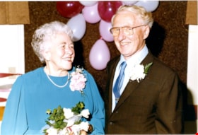
50th wedding anniversary
https://search.heritageburnaby.ca/link/museumdescription5170
- Repository
- Burnaby Village Museum
- Date
- 1985
- Collection/Fonds
- Waplington family fonds
- Description Level
- Item
- Physical Description
- 1 photograph : col. ; 10 x 15 cm
- Scope and Content
- Photograph of Ray and Frances Fleming at the celebration of their 50th wedding anniversary. They each have floral corsages, Frances is holding a bouquet of flowers and there is a bunch of balloons behind them.
- Repository
- Burnaby Village Museum
- Collection/Fonds
- Waplington family fonds
- Description Level
- Item
- Physical Description
- 1 photograph : col. ; 10 x 15 cm
- Scope and Content
- Photograph of Ray and Frances Fleming at the celebration of their 50th wedding anniversary. They each have floral corsages, Frances is holding a bouquet of flowers and there is a bunch of balloons behind them.
- Accession Code
- BV016.46.125
- Access Restriction
- No restrictions
- Reproduction Restriction
- May be restricted by third party rights
- Date
- 1985
- Media Type
- Photograph
- Scan Resolution
- 600
- Scan Date
- 13-Aug-2018
- Notes
- Title based on contents of photograph
- Photograph is part of Photograph album BV016.46.52
Images

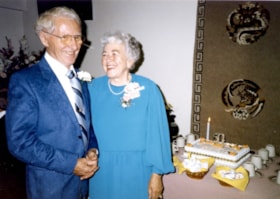
50th wedding anniversary
https://search.heritageburnaby.ca/link/museumdescription5171
- Repository
- Burnaby Village Museum
- Date
- 1985
- Collection/Fonds
- Waplington family fonds
- Description Level
- Item
- Physical Description
- 1 photograph : col. ; 9 x 13 cm
- Scope and Content
- Photograph of Ray and Frances Fleming at the celebration of their 50th wedding anniversary. The smiling couple is standing next to a table with a cake on it.
- Repository
- Burnaby Village Museum
- Collection/Fonds
- Waplington family fonds
- Description Level
- Item
- Physical Description
- 1 photograph : col. ; 9 x 13 cm
- Scope and Content
- Photograph of Ray and Frances Fleming at the celebration of their 50th wedding anniversary. The smiling couple is standing next to a table with a cake on it.
- Accession Code
- BV016.46.126
- Access Restriction
- No restrictions
- Reproduction Restriction
- May be restricted by third party rights
- Date
- 1985
- Media Type
- Photograph
- Scan Resolution
- 600
- Scan Date
- 13-Aug-2018
- Notes
- Title based on contents of photograph
- Photograph is part of Photograph album BV016.46.52
Images


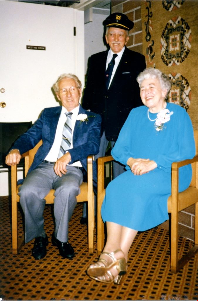
50th wedding anniversary
https://search.heritageburnaby.ca/link/museumdescription5172
- Repository
- Burnaby Village Museum
- Date
- 1985
- Collection/Fonds
- Waplington family fonds
- Description Level
- Item
- Physical Description
- 1 photograph : col. ; 13 x 9 cm
- Scope and Content
- Photograph of Ray and Frances Fleming at the celebration of their 50th wedding anniversary. Both are seated while Frances' brother John Waplington, dressed in a captain's hat is standing in behind them.
- Repository
- Burnaby Village Museum
- Collection/Fonds
- Waplington family fonds
- Description Level
- Item
- Physical Description
- 1 photograph : col. ; 13 x 9 cm
- Scope and Content
- Photograph of Ray and Frances Fleming at the celebration of their 50th wedding anniversary. Both are seated while Frances' brother John Waplington, dressed in a captain's hat is standing in behind them.
- Accession Code
- BV016.46.127
- Access Restriction
- No restrictions
- Reproduction Restriction
- May be restricted by third party rights
- Date
- 1985
- Media Type
- Photograph
- Scan Resolution
- 600
- Scan Date
- 13-Aug-2018
- Notes
- Title based on contents of photograph and notes in photograph album
- Photograph is part of Photograph album BV016.46.52
Images

100 Years of Gilmore School
https://search.heritageburnaby.ca/link/museumdescription4488
- Repository
- Burnaby Village Museum
- Date
- 2017
- Collection/Fonds
- 100 Years of Gilmore School video collection
- Description Level
- Item
- Physical Description
- 1 video recording (mp4) (34 min., 23 sec.) : digital, 29 fps, col., sd., stereo
- Scope and Content
- "100 Years of Gilmore School". Filmed by Yunuen Perez Vertti and made by the Heights Neighbourhood Association. The film includes interviews with former students and highlights their experiences through the Great Depression, the Second World War and the 1960s.
- Repository
- Burnaby Village Museum
- Collection/Fonds
- 100 Years of Gilmore School video collection
- Description Level
- Item
- Physical Description
- 1 video recording (mp4) (34 min., 23 sec.) : digital, 29 fps, col., sd., stereo
- Scope and Content
- "100 Years of Gilmore School". Filmed by Yunuen Perez Vertti and made by the Heights Neighbourhood Association. The film includes interviews with former students and highlights their experiences through the Great Depression, the Second World War and the 1960s.
- History
- Yunuen Perez Vertti is a filmmaker and digital media artist originally from Mexico City. She has produced films for many public, private and non-profit organizations.
- Creator
- Perez Vertti, Yunuen
- Names
- Gilmore Avenue School
- Responsibility
- Heights Neighbourhood Association
- Geographic Access
- Gilmore Avenue
- Street Address
- 50 Gilmore Avenue
- Accession Code
- BV018.13.1
- Access Restriction
- Restricted access
- Reproduction Restriction
- May be restricted by third party rights
- Date
- 2017
- Media Type
- Moving Images
- Historic Neighbourhood
- Vancouver Heights (Historic Neighbourhood)
- Planning Study Area
- Burnaby Heights Area
- Notes
- Transcribed title
- Reproductions are restricted by copyright holder
Images

Video
100 Years of Gilmore School, 2017
100 Years of Gilmore School, 2017
https://search.heritageburnaby.ca/media/hpo/_Data/_BVM_Moving_Images/2018_0013_0001_001.mp4
309 Pine Street
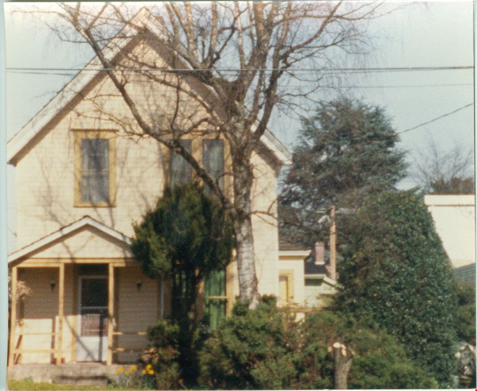
https://search.heritageburnaby.ca/link/museumdescription2814
- Repository
- Burnaby Village Museum
- Date
- 1987
- Collection/Fonds
- Hawkshaw family fonds
- Description Level
- Item
- Physical Description
- 1 photograph : col. ; 10 x 12.5 cm
- Scope and Content
- Photograph of 309 Pine Street, New Westminster. This was John and Mabel Hawkshaw’s first home in 1910.
- Repository
- Burnaby Village Museum
- Collection/Fonds
- Hawkshaw family fonds
- Description Level
- Item
- Physical Description
- 1 photograph : col. ; 10 x 12.5 cm
- Scope and Content
- Photograph of 309 Pine Street, New Westminster. This was John and Mabel Hawkshaw’s first home in 1910.
- Subjects
- Buildings - Residential - Houses
- Geographic Access
- New Westminster
- Accession Code
- BV996.6.288
- Access Restriction
- No restrictions
- Reproduction Restriction
- No known restrictions
- Date
- 1987
- Media Type
- Photograph
- Scan Resolution
- 600
- Scan Date
- 2024-05-07
- Notes
- Title based on contents of photograph
- Note on verso of photograph reads: "1987 / 309 Pine street / New Westminster / John + Mabel Hawkshaw's / 1st home / 1910"
Images

1982 - Moving the Roberts House
https://search.heritageburnaby.ca/link/archivedescription91880
- Repository
- City of Burnaby Archives
- Date
- 1982
- Collection/Fonds
- Small family fonds
- Description Level
- Item
- Physical Description
- 1 photograph : col. copy print ; 10 cm x 15 cm
- Scope and Content
- Photograph of the land being cleared at 5496 Dominion Street in order to create a path to move the Roberts' house onto the property. Included in the clearing are the stumps of two apples trees, a poplar tree, and a maple tree. The debris from the site was burned and smoke can seen rising from a s…
- Repository
- City of Burnaby Archives
- Date
- 1982
- Collection/Fonds
- Small family fonds
- Physical Description
- 1 photograph : col. copy print ; 10 cm x 15 cm
- Description Level
- Item
- Record No.
- 620-061
- Access Restriction
- No restrictions
- Reproduction Restriction
- No reproduction permitted
- Accession Number
- 2017-01
- Scope and Content
- Photograph of the land being cleared at 5496 Dominion Street in order to create a path to move the Roberts' house onto the property. Included in the clearing are the stumps of two apples trees, a poplar tree, and a maple tree. The debris from the site was burned and smoke can seen rising from a small pile of brush on the right.
- Media Type
- Photograph
- Notes
- Transcribed title
- Title transcribed from donor's notes
- Note in blue ink on verso of photograph reads: "p.3"
- Note in pencil on verso of photograph reads: "2"
- Street Address
- 5496 Dominion Street
- Historic Neighbourhood
- Burnaby Lake (Historic Neighbourhood)
- Planning Study Area
- Ardingley-Sprott Area
Images


1982 - Moving the Roberts House
https://search.heritageburnaby.ca/link/archivedescription91881
- Repository
- City of Burnaby Archives
- Date
- September 1982
- Collection/Fonds
- Small family fonds
- Description Level
- Item
- Physical Description
- 1 photograph : col. copy print ; 10 cm x 15 cm
- Scope and Content
- Photograph of the land being cleared at 5496 Dominion Street in order to create a path to move the Roberts' house onto the property. The old garage was demolished, the area dug out and made level for the foundation. The house at 5493 Dominion Street is visible in the background.
- Repository
- City of Burnaby Archives
- Date
- September 1982
- Collection/Fonds
- Small family fonds
- Physical Description
- 1 photograph : col. copy print ; 10 cm x 15 cm
- Description Level
- Item
- Record No.
- 620-062
- Access Restriction
- No restrictions
- Reproduction Restriction
- No reproduction permitted
- Accession Number
- 2017-01
- Scope and Content
- Photograph of the land being cleared at 5496 Dominion Street in order to create a path to move the Roberts' house onto the property. The old garage was demolished, the area dug out and made level for the foundation. The house at 5493 Dominion Street is visible in the background.
- Media Type
- Photograph
- Notes
- Transcribed title
- Title transcribed from donor's notes
- Note in blue ink on verso of photograph reads: "p.4"
- Note in black ink on verso of photograph reads: ""Moving the House" / The Garage is gone! / Sept. 1982"
- 5493 Dominion Street was previously numbered 3107 Dominion Street and was later subdivided into two lots: 5491 and 5495 Dominion Street.
- Street Address
- 5493 Dominion Street
- 5496 Dominion Street
- Historic Neighbourhood
- Burnaby Lake (Historic Neighbourhood)
- Planning Study Area
- Ardingley-Sprott Area
Images


1982 - Moving the Roberts House
https://search.heritageburnaby.ca/link/archivedescription91882
- Repository
- City of Burnaby Archives
- Date
- September 1982
- Collection/Fonds
- Small family fonds
- Description Level
- Item
- Physical Description
- 1 photograph : col. ; 10 cm x 15 cm
- Scope and Content
- Photograph of an excavator making a pathway to move the Roberts' house from 5538 Dominion Street to 5496 Dominion Street. A second excavator works in the background.
- Repository
- City of Burnaby Archives
- Date
- September 1982
- Collection/Fonds
- Small family fonds
- Physical Description
- 1 photograph : col. ; 10 cm x 15 cm
- Description Level
- Item
- Record No.
- 620-063
- Access Restriction
- No restrictions
- Reproduction Restriction
- No reproduction permitted
- Accession Number
- 2017-01
- Scope and Content
- Photograph of an excavator making a pathway to move the Roberts' house from 5538 Dominion Street to 5496 Dominion Street. A second excavator works in the background.
- Media Type
- Photograph
- Notes
- Transcribed title
- Title transcribed from donor's notes
- Note in blue ink on verso of photograph reads: "P5"
- Note in black ink on verso of photograph reads: "3"
- Note in pencil on verso of photograph reads: "4"
- Street Address
- 5496 Dominion Street
- Historic Neighbourhood
- Burnaby Lake (Historic Neighbourhood)
- Planning Study Area
- Ardingley-Sprott Area
Images


1982 - Moving the Roberts House
https://search.heritageburnaby.ca/link/archivedescription91883
- Repository
- City of Burnaby Archives
- Date
- 1982
- Collection/Fonds
- Small family fonds
- Description Level
- Item
- Physical Description
- 1 photograph : col. copy print ; 10 cm x 15 cm
- Scope and Content
- Photograph of the Roberts' house jacked up and supported by iron beams underneath. Three labourers work beneath the lifted house. In order to raise the house, some of the foundation was knocked down. A rear end of a flat bed truck is parked on the grass to the right.
- Repository
- City of Burnaby Archives
- Date
- 1982
- Collection/Fonds
- Small family fonds
- Physical Description
- 1 photograph : col. copy print ; 10 cm x 15 cm
- Description Level
- Item
- Record No.
- 620-064
- Access Restriction
- No restrictions
- Reproduction Restriction
- No reproduction permitted
- Accession Number
- 2017-01
- Scope and Content
- Photograph of the Roberts' house jacked up and supported by iron beams underneath. Three labourers work beneath the lifted house. In order to raise the house, some of the foundation was knocked down. A rear end of a flat bed truck is parked on the grass to the right.
- Media Type
- Photograph
- Notes
- Transcribed title
- Title transcribed from donor's notes
- Note in blue ink on verso of photograph reads: "P.6"
- Note in black ink on verso of photograph reads: "11"
- Note in pencil on verso of photograph reads: "5"
- Street Address
- 5496 Dominion Street
- Historic Neighbourhood
- Burnaby Lake (Historic Neighbourhood)
- Planning Study Area
- Ardingley-Sprott Area
Images


1982 - Moving the Roberts House
https://search.heritageburnaby.ca/link/archivedescription91884
- Repository
- City of Burnaby Archives
- Date
- 1982
- Collection/Fonds
- Small family fonds
- Description Level
- Item
- Physical Description
- 1 photograph : col. ; 10 cm x 15 cm
- Scope and Content
- Photograph of the Roberts' house being moved from 5538 Dominion Street to 5496 Dominion Street. Wheels were attached to both ends of the iron beams supporting the raised house and one set of wheels was attached to a swivel on a flatbed truck to facilitate the move. The furnishings and appliances …
- Repository
- City of Burnaby Archives
- Date
- 1982
- Collection/Fonds
- Small family fonds
- Physical Description
- 1 photograph : col. ; 10 cm x 15 cm
- Description Level
- Item
- Record No.
- 620-065
- Access Restriction
- No restrictions
- Reproduction Restriction
- No reproduction permitted
- Accession Number
- 2017-01
- Scope and Content
- Photograph of the Roberts' house being moved from 5538 Dominion Street to 5496 Dominion Street. Wheels were attached to both ends of the iron beams supporting the raised house and one set of wheels was attached to a swivel on a flatbed truck to facilitate the move. The furnishings and appliances were left inside the house during the move.
- Media Type
- Photograph
- Notes
- Transcribed title
- Title transcribed from donor's notes
- Note in blue ink on verso of photograph reads: "P7"
- Note in black ink on verso of photograph reads: "7"
- Note in pencil on verso of photograph reads: "6"
- Street Address
- 5538 Dominion Street
- 5496 Dominion Street
- Historic Neighbourhood
- Burnaby Lake (Historic Neighbourhood)
- Planning Study Area
- Ardingley-Sprott Area
Images


1982 - Moving the Roberts House
https://search.heritageburnaby.ca/link/archivedescription91885
- Repository
- City of Burnaby Archives
- Date
- September 1982
- Collection/Fonds
- Small family fonds
- Description Level
- Item
- Physical Description
- 1 photograph : col. ; 10 cm x 15 cm
- Scope and Content
- Photograph of the Roberts' house being moved from 5538 Dominion Street to 5496 Dominion Street. Wheels were attached to both ends of the iron beams supporting the raised house and one set wheels was attached to a swivel on a flatbed truck to facilitate the move. The house was turned 90 degrees so…
- Repository
- City of Burnaby Archives
- Date
- September 1982
- Collection/Fonds
- Small family fonds
- Physical Description
- 1 photograph : col. ; 10 cm x 15 cm
- Description Level
- Item
- Record No.
- 620-066
- Access Restriction
- No restrictions
- Reproduction Restriction
- No reproduction permitted
- Accession Number
- 2017-01
- Scope and Content
- Photograph of the Roberts' house being moved from 5538 Dominion Street to 5496 Dominion Street. Wheels were attached to both ends of the iron beams supporting the raised house and one set wheels was attached to a swivel on a flatbed truck to facilitate the move. The house was turned 90 degrees so that it faced Dominion Street.
- Media Type
- Photograph
- Notes
- Transcribed title
- Title transcribed from donor's notes
- Note in blue ink on verso of photograph reads: "P.8"
- Note in black ink on verso of photograph reads: "8"
- Note in pencil on verso of photograph reads: "7"
- Note in black ink on verso of photograph reads: "Moving and Turning 90 [degrees] / Sept. 82"
- Street Address
- 5538 Dominion Street
- 5496 Dominion Street
- Historic Neighbourhood
- Burnaby Lake (Historic Neighbourhood)
- Planning Study Area
- Ardingley-Sprott Area
Images


1982 - Moving the Roberts House
https://search.heritageburnaby.ca/link/archivedescription91886
- Repository
- City of Burnaby Archives
- Date
- 1982
- Collection/Fonds
- Small family fonds
- Description Level
- Item
- Physical Description
- 1 photograph : col. ; 10 cm x 15 cm
- Scope and Content
- Photograph of the Roberts' house nearly in its new position after being moved from 5538 Dominion Street to 5496 Dominion Street. The move took nearly two full days to complete.
- Repository
- City of Burnaby Archives
- Date
- 1982
- Collection/Fonds
- Small family fonds
- Physical Description
- 1 photograph : col. ; 10 cm x 15 cm
- Description Level
- Item
- Record No.
- 620-067
- Access Restriction
- No restrictions
- Reproduction Restriction
- No reproduction permitted
- Accession Number
- 2017-01
- Scope and Content
- Photograph of the Roberts' house nearly in its new position after being moved from 5538 Dominion Street to 5496 Dominion Street. The move took nearly two full days to complete.
- Media Type
- Photograph
- Notes
- Transcribed title
- Title transcribed from donor's notes
- Note in blue ink on verso of photograph reads: "P9"
- Note in black ink on verso of photograph reads: "25"
- Note in pencil on verso of photograph reads: "8"
- Street Address
- 5538 Dominion Street
- 5496 Dominion Street
- Historic Neighbourhood
- Burnaby Lake (Historic Neighbourhood)
- Planning Study Area
- Ardingley-Sprott Area
Images
