Narrow Results By

Cameron Neighbourhood
https://search.heritageburnaby.ca/link/landmark824
- Repository
- Burnaby Heritage Planning
- Associated Dates
- 1955-2008
- Heritage Value
- The Cameron Neighbourhood falls within the Lougheed Town Centre area - one of four Town Centres in Burnaby. The Cameron Neighbourhood - while containing significant high-density residential components - is also home to the Town Centre's office and commercial core. The Lougheed Mall is situated in this neighbourhood, which is served by the Millennium Line SkyTrain.
- Historic Neighbourhood
- Burquitlam (Historic Neighbourhood)
- Planning Study Area
- Cameron Area
Images


Lyndhurst Neighbourhood
https://search.heritageburnaby.ca/link/landmark823
- Repository
- Burnaby Heritage Planning
- Associated Dates
- 1955-2008
- Heritage Value
- The Lyndhurst Neighbourhood falls within the Lougheed Town Centre area - one of four Town Centres in Burnaby. The Lyndhurst Neighbourhood accounts for a significant portion of the residential component of the Town Centre. To the east of Stoney Creek Park, lies the Sullivan Heights single family subdivision which was built in the 1950s. To the west of the park, is a higher-density residential area consisting of multi-family buildings that were developed after 1974.
- Historic Neighbourhood
- Burquitlam (Historic Neighbourhood)
- Planning Study Area
- Lyndhurst Area
Images

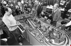
Galen and Mike Montesano
https://search.heritageburnaby.ca/link/archivedescription78689
- Repository
- City of Burnaby Archives
- Date
- November 15, 1995
- Collection/Fonds
- Burnaby NewsLeader photograph collection
- Description Level
- Item
- Physical Description
- 1 photograph : b&w ; 15 x 23.5 cm
- Scope and Content
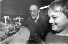
- Photograph of Mike and Galen Montesano looking at the NorWest Club's 1930's model steam engine circle track at the Model Rail Bonanza at Cameron Recreation Centre.
- Repository
- City of Burnaby Archives
- Date
- November 15, 1995
- Collection/Fonds
- Burnaby NewsLeader photograph collection
- Physical Description
- 1 photograph : b&w ; 15 x 23.5 cm
- Description Level
- Item
- Record No.
- 535-0050
- Access Restriction
- No restrictions
- Reproduction Restriction
- No reproduction permitted
- Accession Number
- 2012-11
- Scope and Content
- Photograph of Mike and Galen Montesano looking at the NorWest Club's 1930's model steam engine circle track at the Model Rail Bonanza at Cameron Recreation Centre.
- Subjects
- Recreational Activities
- Media Type
- Photograph
- Photographer
- Langdeau, Brian
- Notes
- Title based on contents of photograph
- Note in black and blue ink on recto of photograph reads: "Bby 1 86% / Bby Brian 3145 B"
- Trim marks and/or reproduction instructions on recto (scan is cropped)
- Geographic Access
- Cameron Street
- Historic Neighbourhood
- Burquitlam (Historic Neighbourhood)
- Planning Study Area
- Cameron Area
Images

Interview with Diane Stiglish by Eric Damer December 4, 2012 - Track 5
https://search.heritageburnaby.ca/link/oralhistory413
- Repository
- City of Burnaby Archives
- Date Range
- 1950-2012
- Length
- 0:08:57
- Summary
- This portion of the recording pertains to Diane Stiglish's memories of the neighbourhood she grew up in and the changes that have occurred there. Diane describes how her parents sold the mushroom farm and built a new home; the property later became a townhouse development. She mentions her brother …
- Repository
- City of Burnaby Archives
- Summary
- This portion of the recording pertains to Diane Stiglish's memories of the neighbourhood she grew up in and the changes that have occurred there. Diane describes how her parents sold the mushroom farm and built a new home; the property later became a townhouse development. She mentions her brother and some of their early neighbours.
- Date Range
- 1950-2012
- Photo Info
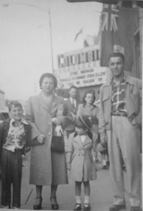
- Diane Stiglish with her parents and older brother in New Westminster, 1955. Item no. 549-067.
- Length
- 0:08:57
- Subjects
- Geographic Features - Neighbourhoods
- Historic Neighbourhood
- Burquitlam (Historic Neighbourhood)
- Interviewer
- Damer, Eric
- Interview Date
- December 4, 2012
- Scope and Content
- Recording is an interview with Diane Stiglish conducted by Burnaby Village Museum employee Eric Damer, December 4, 2012. Major theme discussed: mushroom farming.
- Biographical Notes
- F.J. "Jack" Stiglish (originally spelt Stiglich) and his wife bought a Burnaby home in 1943 at Keswick Street, just south of the Lougheed Highway, and took up mushroom farming. By the time their daughter Diane was born five years later in New Westminster, the F.J. Stiglish mushroom farm was an established business. Mushrooms grown at the F.J. Stiglish farm were sent off to Money’s Mushrooms to be packaged and retailed. Later, mushroom growers bought out Money’s to form the Fraser Valley Mushroom Growers Co-op and nominated Jack Stiglish as their first president. Jack then entered a float in the Pacific National Exhibition (PNE) parade and set up a mushroom booth at the fair. In 1969 Jack Stiglish sold the mushroom farm and he and his wife moved next to their trailer court business just down the road. Diane’s brother Allan Stiglich (his family name returned to the original spelling) moved to Langley to open a large mushroom farm of his own which he established with the help of his father. Diane Stiglish began a career with BC Tel.
- Total Tracks
- 5
- Total Length
- 0:46:06
- Interviewee Name
- Stiglish, Diane
- Interview Location
- Burnaby Village Museum
- Interviewer Bio
- Eric Damer is a lifelong British Columbian born in Victoria, raised in Kamloops, and currently residing in Burnaby. After studying philosophy at the University of Victoria, he became interested in the educational forces that had shaped his own life. He completed master’s and doctoral degrees in educational studies at the University of British Columbia with a particular interest in the history of adult and higher education in the province. In 2012, Eric worked for the City of Burnaby as a field researcher and writer, conducting interviews for the City Archives and Museum Oral History Program.
- Collection/Fonds
- Community Heritage Commission Special Projects fonds
- Transcript Available
- None
- Media Type
- Sound Recording
Images

Audio Tracks
Track five of recording of interview with Diane Stiglish
Track five of recording of interview with Diane Stiglish
https://search.heritageburnaby.ca/media/hpo/_Data/_Archives_Oral_Histories/_Unrestricted/MSS171-026/MSS171-026_Track_5.mp3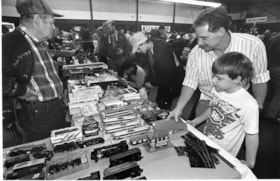
Model Rail Bonanza
https://search.heritageburnaby.ca/link/archivedescription78690
- Repository
- City of Burnaby Archives
- Date
- November, 1995
- Collection/Fonds
- Burnaby NewsLeader photograph collection
- Description Level
- Item
- Physical Description
- 1 photograph : b&w ; 15.5 x 23.5 cm
- Scope and Content
- Photograph of people looking at the Model Rail Bonanza at Cameron Recreation Centre.
- Repository
- City of Burnaby Archives
- Date
- November, 1995
- Collection/Fonds
- Burnaby NewsLeader photograph collection
- Physical Description
- 1 photograph : b&w ; 15.5 x 23.5 cm
- Description Level
- Item
- Record No.
- 535-0051
- Access Restriction
- No restrictions
- Reproduction Restriction
- No reproduction permitted
- Accession Number
- 2012-11
- Scope and Content
- Photograph of people looking at the Model Rail Bonanza at Cameron Recreation Centre.
- Subjects
- Recreational Activities
- Media Type
- Photograph
- Photographer
- Langdeau, Brian
- Notes
- Title based on contents of photograph
- Note in blue ink on recto of photograph reads: "3145 Bby Brian C / 88% Bby p.1"
- Trim marks and/or reproduction instructions on recto (scan is cropped)
- Geographic Access
- Cameron Street
- Historic Neighbourhood
- Burquitlam (Historic Neighbourhood)
- Planning Study Area
- Cameron Area
Images
Model Rail Bonanza
https://search.heritageburnaby.ca/link/archivedescription78691
- Repository
- City of Burnaby Archives
- Date
- November 15, 1995
- Collection/Fonds
- Burnaby NewsLeader photograph collection
- Description Level
- Item
- Physical Description
- 1 photograph : b&w ; 15.5 x 23.5 cm
- Scope and Content
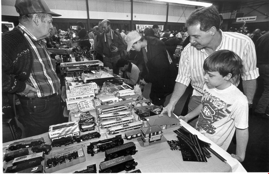
- Photograph of people looking at the Model Rail Bonanza at Cameron Recreation Centre.
- Repository
- City of Burnaby Archives
- Date
- November 15, 1995
- Collection/Fonds
- Burnaby NewsLeader photograph collection
- Physical Description
- 1 photograph : b&w ; 15.5 x 23.5 cm
- Description Level
- Item
- Record No.
- 535-0052
- Access Restriction
- No restrictions
- Reproduction Restriction
- No reproduction permitted
- Accession Number
- 2012-11
- Scope and Content
- Photograph of people looking at the Model Rail Bonanza at Cameron Recreation Centre.
- Subjects
- Recreational Activities
- Media Type
- Photograph
- Photographer
- Langdeau, Brian
- Notes
- Title based on contents of photograph
- Note in blue ink on recto of photograph reads: "Bby Brian 3145 D / Bby 3 86%"
- Trim marks and/or reproduction instructions on recto (scan is cropped)
- Geographic Access
- Cameron Street
- Historic Neighbourhood
- Burquitlam (Historic Neighbourhood)
- Planning Study Area
- Cameron Area
Images

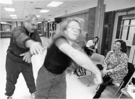
Sara Fox with Robin Webb
https://search.heritageburnaby.ca/link/archivedescription78699
- Repository
- City of Burnaby Archives
- Date
- November 19, 1995
- Collection/Fonds
- Burnaby NewsLeader photograph collection
- Description Level
- Item
- Physical Description
- 1 photograph : b&w ; 17.5 x 24 cm
- Scope and Content
- Photograph of Sara Fox and instructor Robin Webb demonstrating how to pull away from a possible attacker during a self-defense class at Cameron Recreation Centre.
- Repository
- City of Burnaby Archives
- Date
- November 19, 1995
- Collection/Fonds
- Burnaby NewsLeader photograph collection
- Physical Description
- 1 photograph : b&w ; 17.5 x 24 cm
- Description Level
- Item
- Record No.
- 535-0060
- Access Restriction
- No restrictions
- Reproduction Restriction
- No reproduction permitted
- Accession Number
- 2012-11
- Scope and Content
- Photograph of Sara Fox and instructor Robin Webb demonstrating how to pull away from a possible attacker during a self-defense class at Cameron Recreation Centre.
- Media Type
- Photograph
- Photographer
- Bartel, Mario
- Notes
- Title based on contents of photograph
- Note in black and blue ink on recto of photograph reads: "Mario Bby 3186 / 86% Bby 3"
- Trim marks and/or reproduction instructions on recto (scan is cropped)
- Geographic Access
- Cameron Street
- Historic Neighbourhood
- Burquitlam (Historic Neighbourhood)
- Planning Study Area
- Cameron Area
Images

![Stoney Creek, [1998-1999] thumbnail](/media/Hpo/_Data/_Archives_Images/_Unrestricted/316/353-005.jpg?width=280)
Stoney Creek
https://search.heritageburnaby.ca/link/archivedescription66637
- Repository
- City of Burnaby Archives
- Date
- [1998-1999]
- Collection/Fonds
- Millway family fonds
- Description Level
- Item
- Physical Description
- 1 photograph : col. ; 10 x 30.5 cm
- Scope and Content
- Photograph of Stoney Creek taken from above.
- Repository
- City of Burnaby Archives
- Date
- [1998-1999]
- Collection/Fonds
- Millway family fonds
- Physical Description
- 1 photograph : col. ; 10 x 30.5 cm
- Description Level
- Item
- Record No.
- 353-005
- Access Restriction
- No restrictions
- Reproduction Restriction
- Reproduce for fair dealing purposes only
- Accession Number
- 2011-05
- Scope and Content
- Photograph of Stoney Creek taken from above.
- Subjects
- Geographic Features - Creeks
- Media Type
- Photograph
- Notes
- Title based on contents of photograph
- Historic Neighbourhood
- Burquitlam (Historic Neighbourhood)
- Planning Study Area
- Lyndhurst Area
Images
![Stoney Creek, [1998-1999] thumbnail](/media/Hpo/_Data/_Archives_Images/_Unrestricted/316/353-005.jpg)
![Stoney Creek Bridge, [1998-1999] thumbnail](/media/Hpo/_Data/_Archives_Images/_Unrestricted/316/353-006.jpg?width=280)
Stoney Creek Bridge
https://search.heritageburnaby.ca/link/archivedescription66638
- Repository
- City of Burnaby Archives
- Date
- [1998-1999]
- Collection/Fonds
- Millway family fonds
- Description Level
- Item
- Physical Description
- 1 photograph : col. ; 10 x 30.5 cm
- Scope and Content
- Photograph of Stoney Creek Bridge soon after it was built. An unidentified man and woman are visible on the bridge.
- Repository
- City of Burnaby Archives
- Date
- [1998-1999]
- Collection/Fonds
- Millway family fonds
- Physical Description
- 1 photograph : col. ; 10 x 30.5 cm
- Description Level
- Item
- Record No.
- 353-006
- Access Restriction
- No restrictions
- Reproduction Restriction
- Reproduce for fair dealing purposes only
- Accession Number
- 2011-05
- Scope and Content
- Photograph of Stoney Creek Bridge soon after it was built. An unidentified man and woman are visible on the bridge.
- Subjects
- Structures - Bridges
- Media Type
- Photograph
- Notes
- Title based on contents of photograph
- Historic Neighbourhood
- Burquitlam (Historic Neighbourhood)
- Planning Study Area
- Lyndhurst Area
Images
![Stoney Creek Bridge, [1998-1999] thumbnail](/media/Hpo/_Data/_Archives_Images/_Unrestricted/316/353-006.jpg)
![Stoney Creek Bridge, [1998-1999] thumbnail](/media/Hpo/_Data/_Archives_Images/_Unrestricted/316/353-007.jpg?width=280)
Stoney Creek Bridge
https://search.heritageburnaby.ca/link/archivedescription66639
- Repository
- City of Burnaby Archives
- Date
- [1998-1999]
- Collection/Fonds
- Millway family fonds
- Description Level
- Item
- Physical Description
- 1 photograph : col. ; 10 x 30.5 cm
- Scope and Content
- Photograph of Stoney Creek Bridge taken from a distance. A bicycle rider is about to cross the bridge.
- Repository
- City of Burnaby Archives
- Date
- [1998-1999]
- Collection/Fonds
- Millway family fonds
- Physical Description
- 1 photograph : col. ; 10 x 30.5 cm
- Description Level
- Item
- Record No.
- 353-007
- Access Restriction
- No restrictions
- Reproduction Restriction
- Reproduce for fair dealing purposes only
- Accession Number
- 2011-05
- Scope and Content
- Photograph of Stoney Creek Bridge taken from a distance. A bicycle rider is about to cross the bridge.
- Subjects
- Structures - Bridges
- Media Type
- Photograph
- Notes
- Title based on contents of photograph
- Historic Neighbourhood
- Burquitlam (Historic Neighbourhood)
- Planning Study Area
- Lyndhurst Area
Images
![Stoney Creek Bridge, [1998-1999] thumbnail](/media/Hpo/_Data/_Archives_Images/_Unrestricted/316/353-007.jpg)
![Stoney Creek path, [1998-1999] thumbnail](/media/Hpo/_Data/_Archives_Images/_Unrestricted/316/353-008.jpg?width=280)
Stoney Creek path
https://search.heritageburnaby.ca/link/archivedescription66640
- Repository
- City of Burnaby Archives
- Date
- [1998-1999]
- Collection/Fonds
- Millway family fonds
- Description Level
- Item
- Physical Description
- 1 photograph : col. ; 10 x 30.5 cm
- Scope and Content
- Photograph of the paved walking trail that leads to Stoney Creek Bridge.
- Repository
- City of Burnaby Archives
- Date
- [1998-1999]
- Collection/Fonds
- Millway family fonds
- Physical Description
- 1 photograph : col. ; 10 x 30.5 cm
- Description Level
- Item
- Record No.
- 353-008
- Access Restriction
- No restrictions
- Reproduction Restriction
- Reproduce for fair dealing purposes only
- Accession Number
- 2011-05
- Scope and Content
- Photograph of the paved walking trail that leads to Stoney Creek Bridge.
- Subjects
- Geographic Features - Trails
- Media Type
- Photograph
- Notes
- Title based on contents of photograph
- Historic Neighbourhood
- Burquitlam (Historic Neighbourhood)
- Planning Study Area
- Lyndhurst Area
Images
![Stoney Creek path, [1998-1999] thumbnail](/media/Hpo/_Data/_Archives_Images/_Unrestricted/316/353-008.jpg)
![Stoney Creek surrounds, [1998-1999] thumbnail](/media/Hpo/_Data/_Archives_Images/_Unrestricted/316/353-009.jpg?width=280)
Stoney Creek surrounds
https://search.heritageburnaby.ca/link/archivedescription66641
- Repository
- City of Burnaby Archives
- Date
- [1998-1999]
- Collection/Fonds
- Millway family fonds
- Description Level
- Item
- Physical Description
- 1 photograph : col. ; 10 x 30.5 cm
- Scope and Content
- Photograph of the treed area surrounding Stoney Creek.
- Repository
- City of Burnaby Archives
- Date
- [1998-1999]
- Collection/Fonds
- Millway family fonds
- Physical Description
- 1 photograph : col. ; 10 x 30.5 cm
- Description Level
- Item
- Record No.
- 353-009
- Access Restriction
- No restrictions
- Reproduction Restriction
- Reproduce for fair dealing purposes only
- Accession Number
- 2011-05
- Scope and Content
- Photograph of the treed area surrounding Stoney Creek.
- Media Type
- Photograph
- Notes
- Title based on contents of photograph
- Historic Neighbourhood
- Burquitlam (Historic Neighbourhood)
- Planning Study Area
- Lyndhurst Area
Images
![Stoney Creek surrounds, [1998-1999] thumbnail](/media/Hpo/_Data/_Archives_Images/_Unrestricted/316/353-009.jpg)
![Survey and Subdivision plans in New Westminster District Group 1 – Burnaby, Port Moody, [1862-1908] thumbnail](/media/hpo/_Data/_BVM_Cartographic_Material/1977/1977_0093_0026a_001.jpg?width=280)
Survey and Subdivision plans in New Westminster District Group 1 – Burnaby, Port Moody
https://search.heritageburnaby.ca/link/museumdescription6995
- Repository
- Burnaby Village Museum
- Date
- [1862-1908]
- Collection/Fonds
- Burnaby Village Museum Map collection
- Description Level
- File
- Physical Description
- 9 plans : 6 plans : black ink on paper ; 57 x 36.5 cm or smaller + 1 plan : black ink and grahite on paper ; 46.5 x 49 cm + 1 plan : blueprint on paper ; 15.5 x 19.5 cm + cm + 1 plan : graphite on paper ; 25 x 17 cm ; mounted on both sides of board 76 x 102 cm
- Scope and Content
- Item consists of a large board of four New Westminster District subdivision plans mounted on one side and five New Westminster District subdivision plans mounted on the other side. Side A: 1. "Plan / of Subdivision / of a Portion / of / Lot 87 / Group One / New Westminster District / Scale 4 chs…
- Repository
- Burnaby Village Museum
- Collection/Fonds
- Burnaby Village Museum Map collection
- Description Level
- File
- Physical Description
- 9 plans : 6 plans : black ink on paper ; 57 x 36.5 cm or smaller + 1 plan : black ink and grahite on paper ; 46.5 x 49 cm + 1 plan : blueprint on paper ; 15.5 x 19.5 cm + cm + 1 plan : graphite on paper ; 25 x 17 cm ; mounted on both sides of board 76 x 102 cm
- Material Details
- Scales [between 1:792 and 1:3600]
- Index number on edge of board reads: "26"
- Scope and Content
- Item consists of a large board of four New Westminster District subdivision plans mounted on one side and five New Westminster District subdivision plans mounted on the other side. Side A: 1. "Plan / of Subdivision / of a Portion / of / Lot 87 / Group One / New Westminster District / Scale 4 chs = 1 in". Plan is stamped: "Albert J. Hill, Civil Engineer / and / Provincial Land Surveyor, / New Westminster, / B.C." and intialed by: "RB" [sic] (in blue pencil crayon). Names two of the subdivisons of District Lot 87 are identified as, "L.E. Sprott" and "John Ledger". (Geographic location: Burnaby) 2. "Plan of Subdivision / of / Portions of / Lot 136, 131 and Lots 44 and 78 Gr.1 / New Westminster District / Scale 300 ft = 1 inch". Annotation above title reads: "No. 901 / Deposited in Land Registry Office / New Westminster / Aug. 19th 1905 / Charles S. Keith D. Reg." Annotations and signatures at bottom of plan read: "I, William Nelson Draper, / W.H.R. Collister / Charles E. Perkins / E.B. Morgan / make / Surveys / correct / representation / upon / the / Land Registry Act / (sgd) W.N. Draper, P.L.S.". Plan includes a handwritten title: "Lots 136, 131, 44 & 78" and is initialed: "RB" [sic] (in blue pencil crayon) (Geographic location: Burnaby) 3. "Survey / of / a Portion / of / Lot 95, Gr.1 / Scale 1 ch = 1in." Plan is stamped: "Albert J. Hill, Civil Engineer / and / Provincial Land Surveyor, / New Westminster, / B.C." and is initialed : "RB" [sic] (in blue pencil crayon) (Geographic location: Burnaby) 4. Blueprint plan of "Lot 396. Group One." with Scale : 3 chs = 1 in. A two acre portion of District Lot 396 is filled in with red ink." Plan is signed by "Albert J. Hill / B.C.L.S." (Geographic location: Port Moody) Side B: 1. Plan titled "District Lot 92 / Burnaby / Municipality / for sale by / Mahon / McFarland & / Mahon Ltd. / Vancouver, B.C. / Scale : 4 chains to one inch". District Lot 92 is subdivided into 161 lots and identifies roads: Norwich Road, Pole Line Road, Oakland Road, Stanley Road, Burford Road, Dalhousie Road, Brantford Road, Colborne Road, Roberts Road, Vancouver & Westminster Road, B.C. Electric Railway, Gilley Stn. and Burnaby (Power House). The bottom of the plan reads: "G.S. Dawson, P.LS. Vancouver, B.C." (Geographic location: Burnaby) 2. "Plan / of Subdivision / of a Portion / of / Lot 29 / Group 1 / New Westminster District / Scale 2 chs = 1 in". Plan is stamped: "Albert J. Hill, Civil Engineer / and / Provincial Land Surveyor, / New Westminster, / B.C." and is initialed by: "RB" [sic] (in blue pencil crayon) (Geographic location: Burnaby) 3. Small handrawn plan (no title) identifying "Lot 84 / Hydes, Claim" at the centre surrounded by lots and features identified as: "Lot 85", "Lot 93", "Lot 94", "Lot 32", "Lot 82", "Lot 83", "Lot 79", "swamp" and a "Small Lake" (Burnaby Lake). Identifying marks in the right corner of the plan read: "Page 13 / Surveyed by G. Turner / May 62". Plan also includes surveyor's bearing measurements and trails to "Small Lake" (Burnaby Lake). (Geographic location: Burnaby) 4. Untitled plan showing District Lots west of North Road and north of Burnaby Lake including: Lots 2, 4, 6, 8, 15, 10, 56, 148, 57, 58, 40. and Lots 3, 5, 7 east of North Road (Coquitlam). Lots in Burnaby are identifed for timber including: "Heavily Timbered" (Lot 57), " "Some Fir and Cedar" (Lot 40), "Splendid Fir and Cedar" (Lot 143), "Heavy Fir etc" (Lots 143 and 148), " "Fine Cedar" (Lot 15), "Rough Light Timber" (Lot 56). Other features identified at the lower portion of the plan include "Burnaby Lake" and "Brunette River". (Geographic location: Burnaby) 5. Untitled plan drawn in graphite showing sections of District Lot 85 south of Burnaby Lake and north of Hazsard Road. Plan is signed: "Albert J. Hill / B.C.L.S." and dated "12/26/08". Plan is initialed by: "RB" [sic] (in blue pencil crayon) (Geographic location: Burnaby)
- Publisher
- Mahon, McFarland & Mahon Ltd
- Accession Code
- HV977.93.26
- Access Restriction
- No restrictions
- Reproduction Restriction
- No known restrictions
- Date
- [1862-1908]
- Media Type
- Cartographic Material
- Historic Neighbourhood
- Burnaby Lake (Historic Neighbourhood)
- Burquitlam (Historic Neighbourhood)
- Planning Study Area
- Burnaby Lake Area
- Scan Resolution
- 300
- Scale
- 72
- Notes
- Title based on contents of file
- Scale is measured in chains and feet. (One chain equals 792 inches)
- The term "Lot" can also refer to a "District Lot”
Images
![Survey and Subdivision plans in New Westminster District Group 1 – Burnaby, Port Moody, [1862-1908] thumbnail](/media/hpo/_Data/_BVM_Cartographic_Material/1977/1977_0093_0026a_001.jpg)

