Narrow Results By
Subject
- Advertising Medium - Signs and Signboards 9
- Agricultural Tools and Equipment 1
- Agriculture - Farms 1
- Arts - Paintings 8
- Buildings - Civic - Art Galleries 1
- Buildings - Commercial 1
- Buildings - Commercial - Hotels and Motels 1
- Buildings - Commercial - Restaurants 4
- Buildings - Commercial - Stores 7
- Buildings - Industrial 2
- Celebrations - Centennials 3
- Clothing - Uniforms 2

Arrow Neon Sign
https://search.heritageburnaby.ca/link/landmark861
- Repository
- Burnaby Heritage Planning
- Description
- Commercial building.
- Associated Dates
- 1961
- Other Names
- Lost in the 50's Drive-in
- Street View URL
- Google Maps Street View
- Repository
- Burnaby Heritage Planning
- Other Names
- Lost in the 50's Drive-in
- Geographic Access
- Edmonds Street
- Associated Dates
- 1961
- Description
- Commercial building.
- Heritage Value
- The Arrow Neon Sign was built in 1961 by the Neonette Sign Company of New Westminster when this property was opened as the Tomahawk Drive-in Restaurant. The restaurant was later known as Lindy's Burger and in 1990, the business was renamed Lost in the 50's Drive-in. It stands 20-foot tall and is composed of a large double-sided hollow steel panel serpentine arrow mounted on a pole supporting a lexan sign panel measuring approximately 8 feet wide by 4 feet tall. The sign was designed with three illuminated features: a round lamp at the top of the pole, a double-sided rectangular fluorescent sign panel box, and two double-sided rows of orange neon arrows that follow the large serpentine arrow. The Arrow Neon Sign remains as a rare surviving example of neon sign art in the city and is the only historic neon sign in South Burnaby. The sign has gained prominence over the years as it has been associated with this small iconic drive-in which has also been utilized as a set for film production. Additionally, the drive-in has played a prominent role in the Edmonds community as a popular setting for recent "Show and Shine" participants to park their classic cars.
- Locality
- Edmonds
- Historic Neighbourhood
- East Burnaby (Historic Neighbourhood)
- Planning Study Area
- Lakeview-Mayfield Area
- Builder
- Neonette Sign Company
- Community
- Burnaby
- Contributing Resource
- Structure
- Ownership
- Public (local)
- Street Address
- 7741 Edmonds Street
- Street View URL
- Google Maps Street View
Images

![Survey and Subdivision plans in New Westminster District Group 1 – Burnaby
, [1861]-[1910] thumbnail](/media/hpo/_Data/_BVM_Cartographic_Material/1977/1977_0093_0019a_001.jpg?width=280)
Survey and Subdivision plans in New Westminster District Group 1 – Burnaby
https://search.heritageburnaby.ca/link/museumdescription6988
- Repository
- Burnaby Village Museum
- Date
- [1861]-[1910]
- Collection/Fonds
- Burnaby Village Museum Map collection
- Description Level
- File
- Physical Description
- 14 plans : 3 plans : black ink on paper hand col. + 7 plans : black ink on paper + 4 plans : graphite on paper mounted on 2 sides of cardboard 76 x 102 cm
- Scope and Content
- Item consists of a large board of four New Westminster District Gp 1 - subdivision plans mounted on one side and ten New Westminster District Gp 1 - subdivision plans mounted on the other side. Side A: 1. "Plan /of / Lots 166A, 166 and 167 /, Gr.1, N.W.D. / Showing Misconstructed Roads in Gree…
- Repository
- Burnaby Village Museum
- Collection/Fonds
- Burnaby Village Museum Map collection
- Description Level
- File
- Physical Description
- 14 plans : 3 plans : black ink on paper hand col. + 7 plans : black ink on paper + 4 plans : graphite on paper mounted on 2 sides of cardboard 76 x 102 cm
- Material Details
- Scales [between 1:2376 and 1:7920]
- Index number on edge of board reads: "19"
- Scope and Content
- Item consists of a large board of four New Westminster District Gp 1 - subdivision plans mounted on one side and ten New Westminster District Gp 1 - subdivision plans mounted on the other side. Side A: 1. "Plan /of / Lots 166A, 166 and 167 /, Gr.1, N.W.D. / Showing Misconstructed Roads in Green / 5 chs = 1 in.". (plan is drawn in black ink and hand coloured in red, green and orange ink). A section in the centre of the plan is coloured in red ink and identified as "C.S. Richmond" running from the North Arm of Fraser River to Wiggins Road and divided by "New Wiggins Rd. (as gazetted)" (coloured in orange ink) and two"Constructed Road(s)" (coloured in green ink). Plan is initialed by: "RB" [sic] (in blue pencil crayon) 2. Plan of / Subdivision of / Lot 166 / Group One / New Westminster District / Scale 4 chs = 1 in. / Map No 524". Plan is drawn in graphite and signed by "Surrig [sic] Welhams [sic] / P.L.S." Plan is initialed by: "RB" [sic] (in blue pencil crayon) 3. Plan of "Survey / of Highway / For / Burnaby Council / in / Lots 13 _14 / Group One / Scale 4 chs = 1 in." Signed by "Albert J. Hill, P.L.S." Caribou Street and Caribou Road run through the centre of the plan. Plan is stamped: "Albert J. Hill, Civil Engineer / and / Provincial Land Surveyor, / New Westminster, / B.C.". Plan is initialed by: "RB" [sic] (in blue pencil crayon) 4. A Plan of Lots 166A, 166 and 167, Group One, New Westminster District (drawn in graphite). A section in the centre of the plan is identified as "C.S. Richmond" running from the North Arm of Fraser River and divided by "New Wiggins Rd. (as gazetted)" and two "Constructed Road(s)". Plan is initialed by: "RB" [sic] (in blue pencil crayon) Side B: 1. Small plan drawn in black ink (no title) identifying lots north of the "North Arm" of the Fraser River. Lots identified include: Lot 99, Lot 98, Lot 157, Lot 158, Lot 163, Lot 162, Lot 159, Lot 163, Lot 162, Lot 165, Lot 166A, Lot 155B, Lot 155A and Lot 159. "Scale 40 chains to one inch" . Plan is initialed by: "RB" [sic] (in blue pencil crayon) (Geographic location: Burnaby) 2. Small plan drawn in black ink (no title) identifying lots north of the North Arm of the Fraser River as "Lots 155, 155A, 155B, 155C, 162, 163, 164, 165, 166A and 167". Plan is initialed by: "RB" [sic] (in blue pencil crayon) (Geographic location: Burnaby) 3. Small plan drawn in black ink (no title) which identifies "Lot 151 / Reserve/ for / Race Course"; "Reserve / 64 A / L. 152 G.1"; and other Lots: 32, 33, 34, 35, 36, 38, 39. The plan is signed "Surveyor G.Turn [sic] July / 61 / from Vol 40 R.L. notes [sic]" Plan is stamped: "Albert J. Hill, Civil Engineer / and / Provincial Land Surveyor, / New Westminster, / B.C." Plan is initialed by: "RB" [sic] (in blue pencil crayon) (Geographic location: Burnaby) 4. Small plan drawn in black in with faded red colouring on centre lot identified as "Lot 34" running north from "Vancouver Road" . Plan is stamped: "Albert J. Hill, Civil Engineer / and / Provincial Land Surveyor, / New Westminster, / B.C." Plan is initialed by: "RB" [sic] (in blue pencil crayon) (Geographic location: Burnaby) 5. Plan drawn in graphite and identified as "Lot 98, Gr.1," along with the intials "RB" [sic] (both are handwritten in blue crayon pencil on top of plan) The B.C.E.Railway is identified running through the plan along with Jubilee Road and Royal Oak Road. The plan is signed with the name "Wm. Murray" and the Plan is stamped: "Albert J. Hill, Civil Engineer / and / Provincial Land Surveyor, / New Westminster, / B.C.". (Geographic location: Burnaby) 6. Plan drawn in graphite identified as "Port Lot 13, Gr.1" along with the intials "RB" [sic] (both are handwritten in blue crayon pencil on top of plan) Plan is stamped: "Albert J. Hill, Civil Engineer / and / Provincial Land Surveyor, / New Westminster, / B.C.". (Geographic location: Burnaby) 7.Plan drawn in black ink and identified as "Lot 98 G.1" along with the intials "RB" [sic] (both are handwritten in blue crayon pencil on top of plan). A "Road Reservation" is identified running north between "Electric Tramway" and connecting with "Royal Oak Road". Plan is stamped: "Albert J. Hill, Civil Engineer / and / Provincial Land Surveyor, / New Westminster, / B.C." (Geographic location: Burnaby) 8. Plan drawn in black ink and divided into two sections, the upper plan is identified as "Portion / Lots 100 / area / 101, Gr.1" and the lower plan is identified as "Portion L. 3 G. 1" along with the intials "RB" [sic] (these identifiers are handwritten in blue crayon pencil on top of the plan). Portions of Lot 100 and Lot 101 are each divided into 6 sections and the Portion of Lot 3 plan is divided into 24 sections. The plan includes a note in black ink that reads: " Received from Wm Fromme [sic] / from Wm. Trapp / Nov. 28, 1895 / A. J. T...[sic]". (Geographic location: Burnaby) 9. Plan drawn in black ink (no title) identifying soil, buildings and geographic features in southern Burnaby. The plan is bordered by "New Westminster City" (Tenth Avenue and DL 172) to the south east and DL 173 to the south, DL 158 to the west and the B.C.E. Tramway to the north. Plan includes District Lots: 155A, 158, 159, 171, 160, 53 and 95 and identifies soil, marshland and ravines throughout. Plan identifies the following features: a "Team Road" running through Lots 158 and 159 along with "Fair Orchard Soil / Even Surface Throughout / No Ravines", "Gravel and Shingle" (bottom of Lot 158), "North Arm Road" crossing "Byrne Road" and connecting with "Power House Road" which runs north to connect with "Highland Park Station" and the B.C.E. Tramway, "Power Ho" in the northeast corner of DL 160, a "Brook" connected with a "Deep Ravine" running between DL 53, DL 95 and DL 160 along with "Good Soil" and "Fair Orchard Soil" identified nearby in DL 95. Scale is identified as "10 chs = 1 in." Plan is stamped: "Albert J. Hill, Civil Engineer / and / Provincial Land Surveyor, / New Westminster, / B.C." Plan is initialed by: "RB" [sic] (in blue pencil crayon) (Geographic location: Burnaby) 10. Plan drawn in black ink (no title) with Burnaby Lake and Deer Lake at the centre. The plan is bordered by the following District Lots identified as: 117, 118 and 68 to the west, Lots 80, 79 and 85 to the southwest, Lots 11, 13, and 1 (City of New Westminster) to the south east, the North Road boundary to the east and Lots 8, 56, 57, 59, and 136 to the North. The lower right hand corner of the plan has a small inset which reads: "Burnaby Lake" and "Page 19 R.B. Notes". Plan is initialed by: "RB" [sic] (in blue pencil crayon) (Geographic location: Burnaby)
- Creator
- Hill, Albert James
- Accession Code
- HV977.93.19
- Access Restriction
- No restrictions
- Reproduction Restriction
- No known restrictions
- Date
- [1861]-[1910]
- Media Type
- Cartographic Material
- Scan Resolution
- 300
- Scale
- 72
- Notes
- Title based on contents of file
- Scale is measured in chains. (One chain equals 792 inches)
- The term "Lot" can also refer to a "District Lot”
- Some plans are stamped: "Albert J. Hill, Civil Engineer / and / Provincial Land Surveyor, / New Westminster, / B.C." and intialed: "RB" [sic]
Images
![Survey and Subdivision plans in New Westminster District Group 1 – Burnaby
, [1861]-[1910] thumbnail](/media/hpo/_Data/_BVM_Cartographic_Material/1977/1977_0093_0019a_001.jpg)

Sister Cities series
https://search.heritageburnaby.ca/link/archivedescription160
- Repository
- City of Burnaby Archives
- Date
- 1964-2015
- Collection/Fonds
- Mayor's Office fonds
- Description Level
- Series
- Scope and Content
- Series consists of records created during the establishment and maintenance of Sister-City relationships between Burnaby and the cities of Kushiro (Japan), Loughborough (England), El Zapotal (El Salvador), Mesa (Arizona), Gatineau (Quebec), Hwaseong (Korea), Zhongshan City (P.R. China). Records in…
- Repository
- City of Burnaby Archives
- Date
- 1964-2015
- Collection/Fonds
- Mayor's Office fonds
- Series
- Sister Cities series
- Description Level
- Series
- Scope and Content
- Series consists of records created during the establishment and maintenance of Sister-City relationships between Burnaby and the cities of Kushiro (Japan), Loughborough (England), El Zapotal (El Salvador), Mesa (Arizona), Gatineau (Quebec), Hwaseong (Korea), Zhongshan City (P.R. China). Records include: reports, correspondence, photographs and photograph albums, memoranda, newspaper clippings, speeches, certificates, itineraries, presentation material, invitations, agendas, and minutes. The sister city movement gained momentum in North America after the Second World War with a goal to encourage cooperation between international communities. Burnaby became a part of that movement in the hopes that sister city relationships would create meaningful industrial, economic, educational, and cultural ties between Burnaby citizens and those of other countries. Burnaby’s first sister city was Kushiro, Japan. The formal agreement for the establishment of a sister city relationship between the two communities was signed on September 9, 1965. Following this twinning, the two cities have enjoyed numerous exchanges and visits, the records of which are contained within this series. While the sister city status between Burnaby and Kushiro has endured for over three decades, Burnaby has also maintained shorter-lived relationships with Loughborough, England and El Zapotal, El Salvador. The 1986 twinning with Loughborough was undertaken to recognize the importance of that city to the history of Burnaby in that Loughborough was the ancestral home of Burnaby’s namesake, Robert Burnaby. The twinning between Burnaby and El Zapotal came after Mayor Copeland visited El Salvador in the early 1990s and returned with a desire to see the citizens of Burnaby assist in the rebuilding of that community after a 12-year civil war was brought to an end in 1992. In 1998, Burnaby entered into two North American Sister City relationships with Mesa, Arizona and Gatineau, Quebec, and in 2010, it formulated a sister city agreement with Hwaseong, Korea. In 2011, a further agreement was signed with Zhongshan, China which expanded a previous “friendship” agreement into a Sister City relationship. Series also consists of records related to Friendship Agreements with Taichung (Taiwan), Dongcheng District (formerly Chongwen District) of Beijing (P.R. China), Dongli District of Tianjin, Changshu (P.R. China), and Kunming, Yunnan Province (P.R. China); as well as Memorandums of Understanding with a number of other cities. The records in this series reflect both the actions that led up to the creation of these relationships as well as the numerous cultural, economic and educational exchanges that have been undertaken between the communities over the years.
- Media Type
- Textual Record
- Photograph
![Survey and Subdivision plans in New Westminster District Group 1 – Burnaby, Port Moody, [1862-1908] thumbnail](/media/hpo/_Data/_BVM_Cartographic_Material/1977/1977_0093_0026a_001.jpg?width=280)
Survey and Subdivision plans in New Westminster District Group 1 – Burnaby, Port Moody
https://search.heritageburnaby.ca/link/museumdescription6995
- Repository
- Burnaby Village Museum
- Date
- [1862-1908]
- Collection/Fonds
- Burnaby Village Museum Map collection
- Description Level
- File
- Physical Description
- 9 plans : 6 plans : black ink on paper ; 57 x 36.5 cm or smaller + 1 plan : black ink and grahite on paper ; 46.5 x 49 cm + 1 plan : blueprint on paper ; 15.5 x 19.5 cm + cm + 1 plan : graphite on paper ; 25 x 17 cm ; mounted on both sides of board 76 x 102 cm
- Scope and Content
- Item consists of a large board of four New Westminster District subdivision plans mounted on one side and five New Westminster District subdivision plans mounted on the other side. Side A: 1. "Plan / of Subdivision / of a Portion / of / Lot 87 / Group One / New Westminster District / Scale 4 chs…
- Repository
- Burnaby Village Museum
- Collection/Fonds
- Burnaby Village Museum Map collection
- Description Level
- File
- Physical Description
- 9 plans : 6 plans : black ink on paper ; 57 x 36.5 cm or smaller + 1 plan : black ink and grahite on paper ; 46.5 x 49 cm + 1 plan : blueprint on paper ; 15.5 x 19.5 cm + cm + 1 plan : graphite on paper ; 25 x 17 cm ; mounted on both sides of board 76 x 102 cm
- Material Details
- Scales [between 1:792 and 1:3600]
- Index number on edge of board reads: "26"
- Scope and Content
- Item consists of a large board of four New Westminster District subdivision plans mounted on one side and five New Westminster District subdivision plans mounted on the other side. Side A: 1. "Plan / of Subdivision / of a Portion / of / Lot 87 / Group One / New Westminster District / Scale 4 chs = 1 in". Plan is stamped: "Albert J. Hill, Civil Engineer / and / Provincial Land Surveyor, / New Westminster, / B.C." and intialed by: "RB" [sic] (in blue pencil crayon). Names two of the subdivisons of District Lot 87 are identified as, "L.E. Sprott" and "John Ledger". (Geographic location: Burnaby) 2. "Plan of Subdivision / of / Portions of / Lot 136, 131 and Lots 44 and 78 Gr.1 / New Westminster District / Scale 300 ft = 1 inch". Annotation above title reads: "No. 901 / Deposited in Land Registry Office / New Westminster / Aug. 19th 1905 / Charles S. Keith D. Reg." Annotations and signatures at bottom of plan read: "I, William Nelson Draper, / W.H.R. Collister / Charles E. Perkins / E.B. Morgan / make / Surveys / correct / representation / upon / the / Land Registry Act / (sgd) W.N. Draper, P.L.S.". Plan includes a handwritten title: "Lots 136, 131, 44 & 78" and is initialed: "RB" [sic] (in blue pencil crayon) (Geographic location: Burnaby) 3. "Survey / of / a Portion / of / Lot 95, Gr.1 / Scale 1 ch = 1in." Plan is stamped: "Albert J. Hill, Civil Engineer / and / Provincial Land Surveyor, / New Westminster, / B.C." and is initialed : "RB" [sic] (in blue pencil crayon) (Geographic location: Burnaby) 4. Blueprint plan of "Lot 396. Group One." with Scale : 3 chs = 1 in. A two acre portion of District Lot 396 is filled in with red ink." Plan is signed by "Albert J. Hill / B.C.L.S." (Geographic location: Port Moody) Side B: 1. Plan titled "District Lot 92 / Burnaby / Municipality / for sale by / Mahon / McFarland & / Mahon Ltd. / Vancouver, B.C. / Scale : 4 chains to one inch". District Lot 92 is subdivided into 161 lots and identifies roads: Norwich Road, Pole Line Road, Oakland Road, Stanley Road, Burford Road, Dalhousie Road, Brantford Road, Colborne Road, Roberts Road, Vancouver & Westminster Road, B.C. Electric Railway, Gilley Stn. and Burnaby (Power House). The bottom of the plan reads: "G.S. Dawson, P.LS. Vancouver, B.C." (Geographic location: Burnaby) 2. "Plan / of Subdivision / of a Portion / of / Lot 29 / Group 1 / New Westminster District / Scale 2 chs = 1 in". Plan is stamped: "Albert J. Hill, Civil Engineer / and / Provincial Land Surveyor, / New Westminster, / B.C." and is initialed by: "RB" [sic] (in blue pencil crayon) (Geographic location: Burnaby) 3. Small handrawn plan (no title) identifying "Lot 84 / Hydes, Claim" at the centre surrounded by lots and features identified as: "Lot 85", "Lot 93", "Lot 94", "Lot 32", "Lot 82", "Lot 83", "Lot 79", "swamp" and a "Small Lake" (Burnaby Lake). Identifying marks in the right corner of the plan read: "Page 13 / Surveyed by G. Turner / May 62". Plan also includes surveyor's bearing measurements and trails to "Small Lake" (Burnaby Lake). (Geographic location: Burnaby) 4. Untitled plan showing District Lots west of North Road and north of Burnaby Lake including: Lots 2, 4, 6, 8, 15, 10, 56, 148, 57, 58, 40. and Lots 3, 5, 7 east of North Road (Coquitlam). Lots in Burnaby are identifed for timber including: "Heavily Timbered" (Lot 57), " "Some Fir and Cedar" (Lot 40), "Splendid Fir and Cedar" (Lot 143), "Heavy Fir etc" (Lots 143 and 148), " "Fine Cedar" (Lot 15), "Rough Light Timber" (Lot 56). Other features identified at the lower portion of the plan include "Burnaby Lake" and "Brunette River". (Geographic location: Burnaby) 5. Untitled plan drawn in graphite showing sections of District Lot 85 south of Burnaby Lake and north of Hazsard Road. Plan is signed: "Albert J. Hill / B.C.L.S." and dated "12/26/08". Plan is initialed by: "RB" [sic] (in blue pencil crayon) (Geographic location: Burnaby)
- Publisher
- Mahon, McFarland & Mahon Ltd
- Accession Code
- HV977.93.26
- Access Restriction
- No restrictions
- Reproduction Restriction
- No known restrictions
- Date
- [1862-1908]
- Media Type
- Cartographic Material
- Historic Neighbourhood
- Burnaby Lake (Historic Neighbourhood)
- Burquitlam (Historic Neighbourhood)
- Planning Study Area
- Burnaby Lake Area
- Scan Resolution
- 300
- Scale
- 72
- Notes
- Title based on contents of file
- Scale is measured in chains and feet. (One chain equals 792 inches)
- The term "Lot" can also refer to a "District Lot”
Images
![Survey and Subdivision plans in New Westminster District Group 1 – Burnaby, Port Moody, [1862-1908] thumbnail](/media/hpo/_Data/_BVM_Cartographic_Material/1977/1977_0093_0026a_001.jpg)


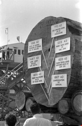
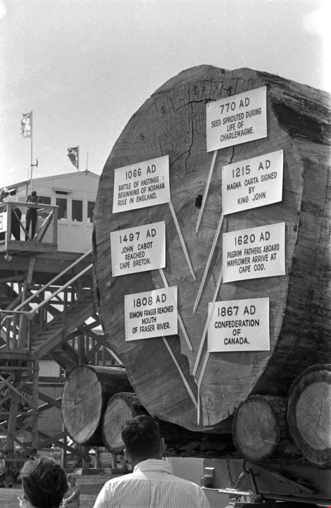
1200 Year Old Log
https://search.heritageburnaby.ca/link/archivedescription51441
- Repository
- City of Burnaby Archives
- Date
- 1967
- Collection/Fonds
- Harold H. Johnston fonds
- Description Level
- Item
- Physical Description
- 1 photograph (jpeg) : b&w
- Scope and Content
- Photograph of a log that has been put on display at the Pacific National Exhibition in Vancouver, BC. The log was dated as being 1200-years old and markers were placed on various rings to date the tree and make mention of historical events that took place in those years. The signs read: 770 AD See…
- Repository
- City of Burnaby Archives
- Date
- 1967
- Collection/Fonds
- Harold H. Johnston fonds
- Physical Description
- 1 photograph (jpeg) : b&w
- Description Level
- Item
- Record No.
- 483-062
- Access Restriction
- No restrictions
- Reproduction Restriction
- No reproduction permitted
- Accession Number
- 2008-08
- Scope and Content
- Photograph of a log that has been put on display at the Pacific National Exhibition in Vancouver, BC. The log was dated as being 1200-years old and markers were placed on various rings to date the tree and make mention of historical events that took place in those years. The signs read: 770 AD Seed sprouted during life of Charlemagne / 1066 AD Battle of Hastings, Beginning of Norman Rule in England / 1215 AD Magna Carta signed by King John / 1497 AD John Cabot Reached Cape Breton / 1620 AD Pilgrim Fathers Aboard Mayflower Arrive at Cape Cod / 1808 AD Simon Fraser Reached Mouth of Fraser River / 1867 AD Confederation of Canada.
- Subjects
- Exhibitions
- Maunfactured Products - Logs
- Media Type
- Photograph
- Photographer
- Johnston, Harold H.
- Notes
- Title based on contents of photograph
Images
Agreement re Paneloc manufacturing limited
https://search.heritageburnaby.ca/link/museumdescription15063
- Repository
- Burnaby Village Museum
- Date
- 15 Nov. 1962
- Collection/Fonds
- Elmer Wilson Martin fonds
- Description Level
- Item
- Physical Description
- 1 p.
- Scope and Content
- Item consists of a lettter of agreement from Paneloc Marketing Limited to Cassady Insley & Cassady regarding "Paneloc Manufacturing Ltd.". The letter is signed by E.W. Martin (President); V.A. Wenaus (Vice President); M.J. Wenaus (Treasurer); C.S. Walker (Stockholder); W.M. Martin (Stockholder).
- Repository
- Burnaby Village Museum
- Collection/Fonds
- Elmer Wilson Martin fonds
- Description Level
- Item
- Physical Description
- 1 p.
- Material Details
- green coloured stationery with letterhead
- Scope and Content
- Item consists of a lettter of agreement from Paneloc Marketing Limited to Cassady Insley & Cassady regarding "Paneloc Manufacturing Ltd.". The letter is signed by E.W. Martin (President); V.A. Wenaus (Vice President); M.J. Wenaus (Treasurer); C.S. Walker (Stockholder); W.M. Martin (Stockholder).
- Accession Code
- BV019.37.14
- Access Restriction
- Restricted access
- Reproduction Restriction
- May be restricted by third party rights
- Date
- 15 Nov. 1962
- Media Type
- Textual Record
- Scan Resolution
- 600
- Scan Date
- February 4, 2021
- Scale
- 100
- Notes
- Title based on contents of item
Apartment study notice addressed to A.G. Shore
https://search.heritageburnaby.ca/link/museumdescription17248
- Repository
- Burnaby Village Museum
- Date
- 8 Mar. 1966
- Collection/Fonds
- Burnaby Village Museum Document collection
- Description Level
- Item
- Physical Description
- 1 p.
- Scope and Content
- Item consists of a notice from the Corporation of the District of Burnaby, addressed to A.G. Shore, 1322 Gilmore Avenue, Burnaby regarding an Apartment Study for proposed apartment developments. The notice is dated March 8, 1966 and is signed by Burnaby Reeve, Alan H. Emmott. Notice is double sid…
- Repository
- Burnaby Village Museum
- Collection/Fonds
- Burnaby Village Museum Document collection
- Description Level
- Item
- Physical Description
- 1 p.
- Scope and Content
- Item consists of a notice from the Corporation of the District of Burnaby, addressed to A.G. Shore, 1322 Gilmore Avenue, Burnaby regarding an Apartment Study for proposed apartment developments. The notice is dated March 8, 1966 and is signed by Burnaby Reeve, Alan H. Emmott. Notice is double sided and includes a map of with locations of apartment development proposals.
- Accession Code
- BV999.10.1
- Access Restriction
- No restrictions
- Reproduction Restriction
- No known restrictions
- Date
- 8 Mar. 1966
- Media Type
- Textual Record
- Notes
- Title based on contents of item
Burnaby Historical Society fonds
https://search.heritageburnaby.ca/link/archivedescription97124
- Repository
- City of Burnaby Archives
- Date
- 1892-2018
- Collection/Fonds
- Burnaby Historical Society fonds
- Description Level
- Fonds
- Physical Description
- ca. 130 linear feet of textual records 30 linear feet of graphic and other material
- Scope and Content
- Fonds consists of the Burnaby Historical Society's administrative records and community archives collection.
- Repository
- City of Burnaby Archives
- Date
- 1892-2018
- Collection/Fonds
- Burnaby Historical Society fonds
- Physical Description
- ca. 130 linear feet of textual records 30 linear feet of graphic and other material
- Description Level
- Fonds
- Scope and Content
- Fonds consists of the Burnaby Historical Society's administrative records and community archives collection.
- History
- The Burnaby Historical Society was founded in 1957. The Historical Society developed a community archives by collecting, compiling and preserving various materials with historical value to the City of Burnaby. It gathered miscellaneous documents, photographs and other items while also soliciting and acquiring entire collections or groups of archival records. In 1991, the Historical Society was provided a permanent space to house their growing collection at the Burnaby Village Museum and they continued to collect and expand their holdings. After the creation of the City of Burnaby Archives in 2001, the Burnaby Historical Society and the City of Burnaby began discussing the possibility of uniting the two collections. In February 2007, an agreement was signed between the two institutions which resulted in the merger of the Society's Community Archives with the City Archives. All records and photographs that had been collected by the Historical Society were transferred into the custody of the City and were moved from the Burnaby Village Museum to the City Archives in the McGill Branch of the Burnaby Public Library. The Burnaby Historical Society disbanded in 2018.
- Media Type
- Textual Record
- Photograph
- Sound Recording
- Creator
- Burnaby Historical Society
- Notes
- Title based on contents of fonds
Bylaws series
https://search.heritageburnaby.ca/link/archivedescription136
- Repository
- City of Burnaby Archives
- Date
- 1892-2010
- Collection/Fonds
- City Council and Office of the City Clerk fonds
- Description Level
- Series
- Scope and Content
- Series consists of all bylaws passed, signed and sealed by the municipal Council of Burnaby, as well as drafts of bylaws that did not receive final adoption or a final reading. Bylaws pertain to all aspects of municipal government, including, but not limited to, public works, land and building reg…
- Repository
- City of Burnaby Archives
- Date
- 1892-2010
- Collection/Fonds
- City Council and Office of the City Clerk fonds
- Series
- Bylaws series
- Description Level
- Series
- Scope and Content
- Series consists of all bylaws passed, signed and sealed by the municipal Council of Burnaby, as well as drafts of bylaws that did not receive final adoption or a final reading. Bylaws pertain to all aspects of municipal government, including, but not limited to, public works, land and building regulation, taxation, finance, licensing, public health and safety, and recreation and culture. Series also includes files of correspondence and other documents related to the development of individual bylaws and municipal bylaw elections, as well as appendices to bylaws, including maps, plans, and engineering related comprehensive development drawings (CD plans). Included also are bylaw record books, which list all bylaws and related information, such as dates of reading and final adoption dates. Bylaws are numbered sequentially and are arranged according to bylaw number.
- Formats
- Microfiche copies are available in the Clerk’s Department vault for bylaws number 1 to 10584.
- Media Type
- Textual Record
CCF records
https://search.heritageburnaby.ca/link/archivedescription82736
- Repository
- City of Burnaby Archives
- Date
- 1956-1978
- Collection/Fonds
- Hazel Simnett collection
- Description Level
- File
- Physical Description
- 1 file of textual records: ill. (some col.)
- Scope and Content
- File consists of two booklets and a newsclipping. The first booklet entitled "Pertinent Portraits" by Barry Mather and Fraser Wilson was originally published in The Commonwealth newspaper in 1934 and re-published by the Boag Foundation in 1978. It contains biographies of CCF members and is signed b…
- Repository
- City of Burnaby Archives
- Date
- 1956-1978
- Collection/Fonds
- Hazel Simnett collection
- Physical Description
- 1 file of textual records: ill. (some col.)
- Description Level
- File
- Record No.
- MSS167-004
- Accession Number
- 2013-22
- Scope and Content
- File consists of two booklets and a newsclipping. The first booklet entitled "Pertinent Portraits" by Barry Mather and Fraser Wilson was originally published in The Commonwealth newspaper in 1934 and re-published by the Boag Foundation in 1978. It contains biographies of CCF members and is signed by Harold Winch. Second booklet entitled "Canadian Labour and Politics" by Clifford A. Scotton provides a short history on the Canadian Labour movement with a chapter focusing on the CCF and the NDP. The newsclipping is from the Seattle Post Intelligencer, dated November 1, 1956. It features an article of President Eisenhower claiming the United States will not get involved in Middle East issues.
- Subjects
- Officials - Elected Officials
- Media Type
- Textual Record
- Notes
- Title based on contents of file
- Simnett political papers series
Completed Mural
https://search.heritageburnaby.ca/link/archivedescription34620
- Repository
- City of Burnaby Archives
- Date
- July 15, 1966
- Collection/Fonds
- Burnaby Historical Society fonds
- Description Level
- Item
- Physical Description
- 1 photograph : b&w negative ; 6.1 x 6.1 cm
- Scope and Content
- Photograph of a completed mural, part of the Burnaby Historical Society's Paint-In on Hastings Street. The mural is signed, "M.H. Apps '66."
- Repository
- City of Burnaby Archives
- Date
- July 15, 1966
- Collection/Fonds
- Burnaby Historical Society fonds
- Subseries
- Photographs subseries
- Physical Description
- 1 photograph : b&w negative ; 6.1 x 6.1 cm
- Description Level
- Item
- Record No.
- 066-024
- Access Restriction
- No restrictions
- Reproduction Restriction
- Reproduce for fair dealing purposes only
- Accession Number
- BHS2007-04
- Scope and Content
- Photograph of a completed mural, part of the Burnaby Historical Society's Paint-In on Hastings Street. The mural is signed, "M.H. Apps '66."
- Subjects
- Arts - Paintings
- Media Type
- Photograph
- Responsibility
- Painted by M.H. Apps
- Notes
- Title based on contents of photograph
- Geographic Access
- Hastings Street
Images
Completed Mural
https://search.heritageburnaby.ca/link/archivedescription34621
- Repository
- City of Burnaby Archives
- Date
- July 15, 1966
- Collection/Fonds
- Burnaby Historical Society fonds
- Description Level
- Item
- Physical Description
- 1 photograph : b&w negative ; 6.3 x 6.1 cm
- Scope and Content
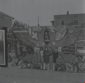
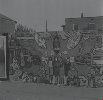
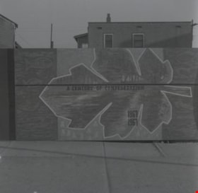
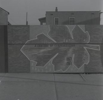
- Photograph of a completed mural, part of the Burnaby Historical Society's Paint-In on Hastings Street. "A Century of Confederation" is painted on the mural, and it is signed "[R.F.] '66."
- Repository
- City of Burnaby Archives
- Date
- July 15, 1966
- Collection/Fonds
- Burnaby Historical Society fonds
- Subseries
- Photographs subseries
- Physical Description
- 1 photograph : b&w negative ; 6.3 x 6.1 cm
- Description Level
- Item
- Record No.
- 066-025
- Access Restriction
- No restrictions
- Reproduction Restriction
- Reproduce for fair dealing purposes only
- Accession Number
- BHS2007-04
- Scope and Content
- Photograph of a completed mural, part of the Burnaby Historical Society's Paint-In on Hastings Street. "A Century of Confederation" is painted on the mural, and it is signed "[R.F.] '66."
- Subjects
- Arts - Paintings
- Media Type
- Photograph
- Notes
- Title based on contents of photograph
- Geographic Access
- Hastings Street
Images
Completed Mural
https://search.heritageburnaby.ca/link/archivedescription34624
- Repository
- City of Burnaby Archives
- Date
- July 15, 1966
- Collection/Fonds
- Burnaby Historical Society fonds
- Description Level
- Item
- Physical Description
- 1 photograph : b&w negative ; 6.0 x 6.1 cm
- Scope and Content
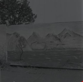
- Photograph of a completed mural, part of the Burnaby Historical Society's Paint-In on Hastings Street. The mural is of a landscape and is signed "R. Craig."
- Repository
- City of Burnaby Archives
- Date
- July 15, 1966
- Collection/Fonds
- Burnaby Historical Society fonds
- Subseries
- Photographs subseries
- Physical Description
- 1 photograph : b&w negative ; 6.0 x 6.1 cm
- Description Level
- Item
- Record No.
- 066-028
- Access Restriction
- No restrictions
- Reproduction Restriction
- Reproduce for fair dealing purposes only
- Accession Number
- BHS2007-04
- Scope and Content
- Photograph of a completed mural, part of the Burnaby Historical Society's Paint-In on Hastings Street. The mural is of a landscape and is signed "R. Craig."
- Subjects
- Arts - Paintings
- Media Type
- Photograph
- Responsibility
- Painted by R. Craig
- Notes
- Title based on contents of photograph
- Geographic Access
- Hastings Street
Images

Completed Mural
https://search.heritageburnaby.ca/link/archivedescription34626
- Repository
- City of Burnaby Archives
- Date
- July 15, 1966
- Collection/Fonds
- Burnaby Historical Society fonds
- Description Level
- Item
- Physical Description
- 1 photograph : b&w negative ; 6.2 x 6.1 cm
- Scope and Content
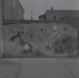
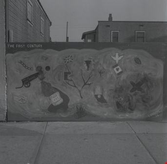
- Photograph of a completed mural, part of the Burnaby Historical Society's Paint-In on Hastings Street. The mural is captioned "First Century," and some of the elements it includes are a cannon with "viva la Quebec" written on the side and a scroll with "1867 BNA" written on it. The mural is signed…
- Repository
- City of Burnaby Archives
- Date
- July 15, 1966
- Collection/Fonds
- Burnaby Historical Society fonds
- Subseries
- Photographs subseries
- Physical Description
- 1 photograph : b&w negative ; 6.2 x 6.1 cm
- Description Level
- Item
- Record No.
- 066-030
- Access Restriction
- No restrictions
- Reproduction Restriction
- Reproduce for fair dealing purposes only
- Accession Number
- BHS2007-04
- Scope and Content
- Photograph of a completed mural, part of the Burnaby Historical Society's Paint-In on Hastings Street. The mural is captioned "First Century," and some of the elements it includes are a cannon with "viva la Quebec" written on the side and a scroll with "1867 BNA" written on it. The mural is signed "T. Knapfl '66."
- Subjects
- Arts - Paintings
- Media Type
- Photograph
- Responsibility
- Painted by T. Knapfl
- Notes
- Title based on contents of photograph
- BNA appears to refer to The British North America Act 1867
- Geographic Access
- Hastings Street
Images

Completed Mural
https://search.heritageburnaby.ca/link/archivedescription34627
- Repository
- City of Burnaby Archives
- Date
- July 15, 1966
- Collection/Fonds
- Burnaby Historical Society fonds
- Description Level
- Item
- Physical Description
- 1 photograph : b&w negative ; 6.4 x 6.1 cm
- Scope and Content
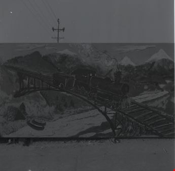
- Photograph of a completed mural, part of the Burnaby Historical Society's Paint-In on Hastings Street. The mural includes a locomotive and is signed "Peter Turner / Mark Jantz."
- Repository
- City of Burnaby Archives
- Date
- July 15, 1966
- Collection/Fonds
- Burnaby Historical Society fonds
- Subseries
- Photographs subseries
- Physical Description
- 1 photograph : b&w negative ; 6.4 x 6.1 cm
- Description Level
- Item
- Record No.
- 066-031
- Access Restriction
- No restrictions
- Reproduction Restriction
- Reproduce for fair dealing purposes only
- Accession Number
- BHS2007-04
- Scope and Content
- Photograph of a completed mural, part of the Burnaby Historical Society's Paint-In on Hastings Street. The mural includes a locomotive and is signed "Peter Turner / Mark Jantz."
- Subjects
- Arts - Paintings
- Media Type
- Photograph
- Responsibility
- Painted by Peter Turner and Mark Jantz
- Notes
- Title based on contents of photograph
- Geographic Access
- Hastings Street
Images
Completed Mural
https://search.heritageburnaby.ca/link/archivedescription34629
- Repository
- City of Burnaby Archives
- Date
- July 15, 1966
- Collection/Fonds
- Burnaby Historical Society fonds
- Description Level
- Item
- Physical Description
- 1 photograph : b&w negative ; 4.5 x 4.6 cm
- Scope and Content
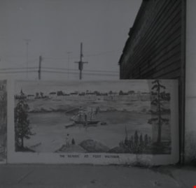
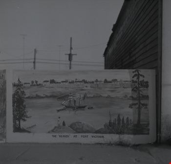
- Photograph of a completed mural, part of the Burnaby Historical Society's Paint-In on Hastings Street. The mural includes a ship and is titled "The 'Beaver' at Fort Victoria." It is signed, "[D. Otanen]."
- Repository
- City of Burnaby Archives
- Date
- July 15, 1966
- Collection/Fonds
- Burnaby Historical Society fonds
- Subseries
- Photographs subseries
- Physical Description
- 1 photograph : b&w negative ; 4.5 x 4.6 cm
- Description Level
- Item
- Record No.
- 066-033
- Access Restriction
- No restrictions
- Reproduction Restriction
- Reproduce for fair dealing purposes only
- Accession Number
- BHS2007-04
- Scope and Content
- Photograph of a completed mural, part of the Burnaby Historical Society's Paint-In on Hastings Street. The mural includes a ship and is titled "The 'Beaver' at Fort Victoria." It is signed, "[D. Otanen]."
- Subjects
- Arts - Paintings
- Media Type
- Photograph
- Notes
- Title based on contents of photograph
- Geographic Access
- Hastings Street
Images
Confederation Civil Defense Building
https://search.heritageburnaby.ca/link/archivedescription2230
- Repository
- City of Burnaby Archives
- Date
- 1969-1973
- Collection/Fonds
- Fire Department fonds
- Description Level
- Item
- Physical Description
- Textual record
- Scope and Content
- A notebook in which is recorded information regarding people who signed out the key to the Civil Defense Building in Confederation Park.
- Repository
- City of Burnaby Archives
- Date
- 1969-1973
- Collection/Fonds
- Fire Department fonds
- Physical Description
- Textual record
- Description Level
- Item
- Record No.
- 4119
- Accession Number
- 2001-02
- Scope and Content
- A notebook in which is recorded information regarding people who signed out the key to the Civil Defense Building in Confederation Park.
- Media Type
- Textual Record
Ettinger family subseries
https://search.heritageburnaby.ca/link/archivedescription36
- Repository
- City of Burnaby Archives
- Date
- 1898-1971
- Collection/Fonds
- Burnaby Historical Society fonds
- Description Level
- Subseries
- Physical Description
- Textual records and photographs
- Scope and Content
- Subseries consists of photographs, newspaper clippings and legal documents related to the Ettinger family of Burnaby.
- Repository
- City of Burnaby Archives
- Date
- 1898-1971
- Collection/Fonds
- Burnaby Historical Society fonds
- Subseries
- Ettinger family subseries
- Physical Description
- Textual records and photographs
- Description Level
- Subseries
- Accession Number
- BHS2002-03
- Scope and Content
- Subseries consists of photographs, newspaper clippings and legal documents related to the Ettinger family of Burnaby.
- History
- James Gilmore Ettinger was born in Noel Road, Nova Scotia in 1863. He worked his way across Canada with the Canadian Pacific Railway (CPR) and landed in New Westminster in 1888. He was one of the first men who helped log the area for the settlement that is now Burnaby. With two other men, James started a brick manufacturing plant in the area of Deer Lake. In 1889, a second brick plant was started on Brickyard Road in Surrey on the bank of the Fraser River. Martha Harriet Hembrough was born in Leeds, England in 1874 and later moved to Haney. James Gilmore and Martha married in 1890 and had seven children: Evelina "Eve" (b. August 8, 1891, d. January 1, 1976); Ella May (b. ca. 1894, d. February 1983); Leonard; George William "Bill" (b. February 18, 1899, d. November 26, 1970); Stanley (b. December 27, 1901, d. March 10, 1966); Ethel (b. ca. 1904, d. December 22, 1982); and James. On May 19, 1911, the Ettingers bought parcel Lot 8, Block C sub-division 19 and 20 of DL 95 no. 556 for $350.00. Their eldest daughter, Evelina was signed over the Deed of Land for this property on April 21, 1914. In 1919, the Ettinger family was living at 1177 19th Avenue, Edmonds, Burnaby. James worked as a Road Foreman in Edmonds, and later as ward foreman for the Municipality. Ella May married Charles Morton Marshall on July 7, 1926. Evelina married Don Digby (d. October 21, 1965) on April 30, 1930. Ethel married George H. McKennell (d. June 18, 1985) on March 16, 1931. Bill worked as a Pacific Stage Lines (PSL) bus operator who “pulled” the first bus service between Vancouver and New Westminster and between Vancouver and Chilliwack in 1924. He received a number of National Safety Council non-accident awards during his career. He married Jane Wilson on July 11, 1931. James Gilmore died on June 9, 1948 at the age of 85. Martha died on February 9, 1955 at the age of 80.
- Media Type
- Textual Record
- Photograph
- Creator
- Ettinger, James Gilmore
- Notes
- Title based on contents of subseries
- PC 428, MSS147
Interpreting our heritage
https://search.heritageburnaby.ca/link/museumlibrary985
- Repository
- Burnaby Village Museum
- Author
- Tilden, Freeman, 1883-1980
- Edition
- Rev. ed.
- Publication Date
- c1967
- Call Number
- 973.07 TIL
- Repository
- Burnaby Village Museum
- Collection
- Reference Collection
- Material Type
- Book
- ISBN
- 0807840165
- Call Number
- 973.07 TIL
- Edition
- Rev. ed.
- Author
- Tilden, Freeman, 1883-1980
- Place of Publication
- Chapel Hill, [N.C.]
- Publisher
- University of North Carolina Press
- Publication Date
- c1967
- Physical Description
- xviii, 120 p. illus. 21 cm.
- Inscription
- "John Thomson / 7231 E. Broadway / Burnaby B.C./ 298-8861" signed and printed in block letters in blue ink on subtitle page.
- Library Subject (LOC)
- United States. National Park Service
- United States--History--Study and teaching
- United States--Description and travel
- Notes
- Includes index.
Interview with John Gordon Davis November 21, 2002 - Tape 1
https://search.heritageburnaby.ca/link/museumdescription13082
- Repository
- Burnaby Village Museum
- Date
- [1940-1989] (interview content), November 21, 2002 (interview date), digitized in 2020
- Collection/Fonds
- Burnaby Village Museum Oral History collection
- Description Level
- Item
- Physical Description
- 1 audio cassette (50 min., 53 sec)
- Scope and Content
- Recording is an interview with (John) Gordon Davis conducted by Mabel F. Nichols with her husband Jack Nichols. Mabel is interviewing Gordon as part of a research project to provide background information to the Burnaby Village Museum who are accepting a donation of Gordon's wife Anne's World War I…
- Repository
- Burnaby Village Museum
- Collection/Fonds
- Burnaby Village Museum Oral History collection
- Description Level
- Item
- Physical Description
- 1 audio cassette (50 min., 53 sec)
- Material Details
- Interviewer: Mabel F. Nichols and husband Jack Nichols Interviewee: John Gordon Davis Location of Interview: New Westminster Interview Date: November 21, 2002 Total Number of tracks: 2 (side A & B of audio cassette) Total Length of all Tracks: 50 min., 53 sec.
- Scope and Content
- Recording is an interview with (John) Gordon Davis conducted by Mabel F. Nichols with her husband Jack Nichols. Mabel is interviewing Gordon as part of a research project to provide background information to the Burnaby Village Museum who are accepting a donation of Gordon's wife Anne's World War II nursing uniform. Gordon provides background information on his family history and describes his experiences while serving overseas during World War II (WWII) including his experiences as a radar operator and working at a military air squadron repair depot. Gordon also provides biographical information about his wife Anne Davis (nee Williams) and her experiences serving as a military nurse during WWII and their life in Burnaby. Interviewer, Mabel and Jack Nichols also provide anecdotal stories about their own life in Burnaby during the interview. Track 1 - Side A (30:34) 00:00 - 30:34 Interview opens with discussion between interviewer Mabel F. Nichols and Gordon Davis about his wife, Anne Davis' experience working in the nursing corps. Mr. Davis provides background information about working in mining between 1933 and 1940 before training in Ontario to become a radar operator during World War II. Gordon also describes his parents origins and how they moved to Burnaby in 1940 while Gordon headed off to Nova Scotia to serve with the RCAF. Gordon also shares information about his sister Anne Davis who married George L. Davis from Kirkland Lake and how they lived with Gordon's parents in the auto court in Burnaby. He tells of how George L. Davis worked for Dominion Bridge Co. and later as a meat cutter for Safeway near 6th Avenue and Kingsway in Burnaby. Mabel shares her own husband Jack's experiences growing up in Burnaby as the son of butcher, George Nichols, his career as a deisel mechanic and later in the GVRD Engineering Department. Gordon shares that his father, Gilbert died in 1957 and his mother Elizabeth died in 1968 and his older sister Ruth died in 1990. Gordon recollects his wedding day and honeymoon in North Wales in 1945 with his wife Anne. Track 2 - Side B (29:19) 00:00 - 14:37 Gordon continues with his recollections about his wedding and honeymoon in North Wales in 1945. The interviewers, Mabel and Jack discuss the geography of the area sharing their own experiences travelling in 1981 and try to get an idea of where Gordon and his wife were married. They agree that the place was Llandudno. He tells of signing up for another year of Military Service since his wife was still serving in the nursing corps. and describes working North of London at a Military facility to repair aircraft including mosquito bombers. 14:38 - 21: 53 Gordon shares information about working in the Middle East in 1943 while his wife Anne survived the bombing of the Dutch passenger ship, the Marnix that she was travelling on. Gordon tells of how Anne couldn't swim but had a life jacket on and was picked up by a life boat. Anne corresponded with Gordon to let him know that she was alright but had to be cryptic since all letters were censored. Gordon tells of how Anne then travelled to India. Interviewer, Mabel, speaks of her own brother Bill who was picked up in Gibralter and taken to England. 21:54 - 26:18 Gordon recollects first meeting his wife Anne in London and the bombing that occurred during WWII. He tells of how Anne trained as a midwife at the Royal College of Midwives in Yorkshire and how he attended Radio college in Ontario. 26:19- 29:19 Gordon speaks about his experience travelling east on the Queen Mary in World War II and how full the ship was. He says that they were 30 days at sea from May to June in 1942.
- History
- Interviewee biography: John Gordon Davis was born to Elizabeth Ann Vert (nee Eyres) and Gilbert Davis on September 13, 1913 in North Cobalt, Ontario. Gordon was the second youngest of six children. After graduating from high school he attended Radio College in Toronto. He spent two years prior to World War II working in radio on British ships. In 1940, after retiring, his parents moved to British Columbia. They purchased the Flowerland Auto Court in 1941 at 4212 Douglas Road, Burnaby. During this time, Gordon moved to Ontario and sought employment in radio range stations that were dealing with new technology throughout Europe. He joined the RCAF in 1941. While in London, in May of 1941, he met his future wife Anne Williams. In World War II, Anne served as a nurse in Queen Alexandra's Imperial Army Nursing Corps. In November 1943, Anne survived the bombing of the Dutch passenger ship, SS Marnix while it sailed in a convoy from England to the Mediterranean. Gordon did many tours throughout the Middle East, Turkey, Egypt, Italy, the Battle of the Bulge, Sarnia before he was known as “surplus to requirement”. Since Anne was still in the nursing corps, Gordon signed on for another year and was sent north of London to a Repair Squadron where he worked on operational repairs of Mosquito bombers which were manufactured in Canada. Anne and Gordon continued their correspondence and eventually married in North Wales on January 23, 1945. Gordon was shipped back to Canada in October of 1945 and moved in with his parents at their auto court on Douglas Road in Burnaby. Anne joined Gordon in Burnaby in April 1946 when her mission was completed. Anne packed up her things in a large trunk that she addressed to Gordon’s parents on Douglas Road. Gordon moved around British Columbia in his work for BC Electric and eventually retired with HB Contracting Ltd. in Surrey working on the BC pipeline between 1953 and 1954. In the late 1950s, Gordon and Anne purchased a home in Burnaby at 1508 6th Street (now 7591 6th Street) which they lived in until 1984. In 1985, Anne and Gordon sold their house in Burnaby and moved to Hyack House in New Westminster. Anne Davis died in 1989 at the age of 76 years. Gordon's father, Gilbert died in 1957 and his mother Elizabeth Ann Verta died in 1968. Interviewer biography: Mabel F. Nichols (nee Lawrence) was one of six children born in Hope [ca.1932] to Elmer E. Lawrence and Louise (nee Pennier). Elmer and Louise married in Yale B.C. in 1916. Mabel’s mother, Louise Pennier was part of the Sts'ailes Nation (Chehalis First Nation). Elmer and Louise had three sons and three daughters. Both of Mabel’s parents died in Langley in 1960. Mabel married Jack (John) Nichols [between 1959 and 1960]. They lived at 6004 Wilson Street, Burnaby in 1959; 4910 Willingdon Avenue [between 1960 and 1962] and 4662 Hazel Street [between 1963 and 1987] before moving to Surrey. Jack Nichols' parents, George and Alma Nichols owned and operated Nichols Family Meat Market at 4018 Kingsway (later renumbered 4500 Kingsway). The family lived behind the butcher shop.
- Names
- Davis, John Gordon "Gordon"
- Davis, Anne Williams
- Davis, Gilbert
- Nichols, Mabel F. Lawrence
- Nichols Family Meat Market
- Accession Code
- BV005.37.1
- Access Restriction
- Restricted access
- Reproduction Restriction
- May be restricted by third party rights
- Date
- [1940-1989] (interview content), November 21, 2002 (interview date), digitized in 2020
- Media Type
- Sound Recording
- Notes
- Title based on contents of sound recording
- Recording is closed due to poor sound quality
- See also: Anne Davis' (nee Williams) WWII nursing uniform- BV003.15.10 & BV03.15.11 & BV003.15.12