Narrow Results By
Subject
- Advertising Medium 1
- Advertising Medium - Signs and Signboards 11
- Aerial Photographs 1
- Arts - Paintings 1
- Buildings 1
- Buildings - Civic 1
- Buildings - Commercial 10
- Buildings - Commercial - Automobile Dealerships 1
- Buildings - Commercial - Department Stores 1
- Buildings - Commercial - Drive-In Theatres 1
- Buildings - Commercial - Drive-in Theatres 7
- Buildings - Commercial - Drugstores 1
Creator
- Asbia, Cher 2
- Cheung, Nakita 6
- Cheung, Ray 5
- Ford, Rolly 1
- Grant-Mann Lithographers Limited 1
- Jerome, Ron 3
- Johnston, Harold H. 5
- King, Gloria 1
- Printed on back of postcard: "Pub. by Living Colour Advertising Agencies, 809 21st St., New West'r, BC - 526-6612" and "Made in Canada / Dexter Color, Canada Ltd., Cornwall, Ontario" 1
- Printed on back of postcard: "Pub, by Natural Color Productions, Ltd., Vancouver, B.C.," "Made in Canada, Grant-Mann," and "GM: Lithography, Photography, Design" 1
- Snowdon, Nick 3
Oh! Zhhu Sam
https://search.heritageburnaby.ca/link/archivedescription98681
- Repository
- City of Burnaby Archives
- Date
- 2022
- Collection/Fonds
- Disappearing Burnaby collection
- Description Level
- Item
- Physical Description
- 1 photograph (jpeg) : col.
- Scope and Content
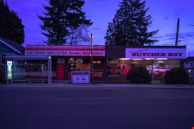
- Photograph of the 7500 block of Edmonds Street at dusk. The photograph is taken from across Edmonds Street and depicts two commercial buildings: Oh! Zzhu Sam Korean Restaurant and the European Butcher Boy Delicatessen & Grocery. Oh! Zzhu Sam, located at 7506 Edmonds Street, was constructed in 1976.…
- Repository
- City of Burnaby Archives
- Date
- 2022
- Collection/Fonds
- Disappearing Burnaby collection
- Physical Description
- 1 photograph (jpeg) : col.
- Description Level
- Item
- Record No.
- 634-028
- Access Restriction
- No restrictions
- Reproduction Restriction
- No restrictions
- Accession Number
- 2022-14
- Scope and Content
- Photograph of the 7500 block of Edmonds Street at dusk. The photograph is taken from across Edmonds Street and depicts two commercial buildings: Oh! Zzhu Sam Korean Restaurant and the European Butcher Boy Delicatessen & Grocery. Oh! Zzhu Sam, located at 7506 Edmonds Street, was constructed in 1976. Residential houses border the restaurant and grocery store, and a bus shelter, municipal garbage can, and the restaurant's illuminated neon sign stand in front of the buildings.
- Subjects
- Buildings - Commercial
- Buildings - Commercial - Grocery Stores
- Buildings - Commercial - Restaurants
- Media Type
- Photograph
- Photographer
- Cheung, Nakita
- Notes
- Title taken from the associated blog post
- Associated blog post: https://disappearingburnaby.wordpress.com/2022/07/29/oh-zzhu-sam/
- Geographic Access
- Edmonds Street
- Street Address
- 7506 Edmonds Street
- Historic Neighbourhood
- Edmonds (Historic Neighbourhood)
- Planning Study Area
- Edmonds Area
Images
Trafalgar Market
https://search.heritageburnaby.ca/link/archivedescription98665
- Repository
- City of Burnaby Archives
- Date
- 2022
- Collection/Fonds
- Disappearing Burnaby collection
- Description Level
- Item
- Physical Description
- 1 photograph (jpeg) : col.
- Scope and Content
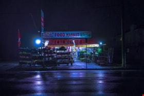
- Photograph of the intersection of Imperial Street and Sussex Avenue at night and in the rain. The photograph shows the Trafalgar Market grocery store (located at 4398 Imperial Street; the building was constructed in 1940) on the corner, with a large display of flowers for sale under the awning in f…
- Repository
- City of Burnaby Archives
- Date
- 2022
- Collection/Fonds
- Disappearing Burnaby collection
- Physical Description
- 1 photograph (jpeg) : col.
- Description Level
- Item
- Record No.
- 634-012
- Access Restriction
- No restrictions
- Reproduction Restriction
- No restrictions
- Accession Number
- 2022-14
- Scope and Content
- Photograph of the intersection of Imperial Street and Sussex Avenue at night and in the rain. The photograph shows the Trafalgar Market grocery store (located at 4398 Imperial Street; the building was constructed in 1940) on the corner, with a large display of flowers for sale under the awning in front of the store. The street and traffic lights are reflected in the puddles on the road, and cars and other businesses are visible along Imperial Street.
- Subjects
- Buildings - Commercial
- Buildings - Commercial - Grocery Stores
- Buildings - Commercial - Stores
- Geographic Features - Roads
- Media Type
- Photograph
- Photographer
- Cheung, Nakita
- Notes
- Title taken from the associated blog post
- Associated blog post: https://disappearingburnaby.wordpress.com/2022/02/20/imperial-manor-2/
- Geographic Access
- Imperial Street
- Sussex Avenue
- Street Address
- 4398 Imperial Street
- Historic Neighbourhood
- Central Park (Historic Neighbourhood)
- Planning Study Area
- Sussex-Nelson Area
Images
Canadian Food Market
https://search.heritageburnaby.ca/link/archivedescription98666
- Repository
- City of Burnaby Archives
- Date
- 2022
- Collection/Fonds
- Disappearing Burnaby collection
- Description Level
- Item
- Physical Description
- 1 photograph (jpeg) : col.
- Scope and Content
- Photograph of the exterior of the Canadian Food Market, taken from across Imperial Street at night. The grocery store is located at 4378 Imperial Street and the building was constructed in 1962. A large display of plants and flowers stands in front of the store and is illuminated by bright lights.
- Repository
- City of Burnaby Archives
- Date
- 2022
- Collection/Fonds
- Disappearing Burnaby collection
- Physical Description
- 1 photograph (jpeg) : col.
- Description Level
- Item
- Record No.
- 634-013
- Access Restriction
- No restrictions
- Reproduction Restriction
- No restrictions
- Accession Number
- 2022-14
- Scope and Content
- Photograph of the exterior of the Canadian Food Market, taken from across Imperial Street at night. The grocery store is located at 4378 Imperial Street and the building was constructed in 1962. A large display of plants and flowers stands in front of the store and is illuminated by bright lights.
- Media Type
- Photograph
- Photographer
- Cheung, Nakita
- Notes
- Title taken from the associated blog post
- Associated blog post: https://disappearingburnaby.wordpress.com/2022/02/20/imperial-manor-2/
- Geographic Access
- Imperial Street
- Street Address
- 4378 Imperial Street
- Historic Neighbourhood
- Central Park (Historic Neighbourhood)
- Planning Study Area
- Sussex-Nelson Area
Images
Interview with Tony and Hazel Padula by Eric Damer November 27, 2012 - Track 3
https://search.heritageburnaby.ca/link/oralhistory373
- Repository
- City of Burnaby Archives
- Date Range
- 1940-1965
- Length
- 0:10:25
- Summary
- This portion of the recording pertains to Tony Padula and Hazel (Bongea) Padula's memories of night life the nineteen-forties and fifties. Tony and Hazel discuss Italian restaurants and dance halls in Vancouver and Tony mentions playing in a dance orchestra in the nineteen-forties. Tony and Hazel m…
- Repository
- City of Burnaby Archives
- Summary
- This portion of the recording pertains to Tony Padula and Hazel (Bongea) Padula's memories of night life the nineteen-forties and fifties. Tony and Hazel discuss Italian restaurants and dance halls in Vancouver and Tony mentions playing in a dance orchestra in the nineteen-forties. Tony and Hazel mention department stores in that era as well.
- Date Range
- 1940-1965
- Photo Info
- Hazel (Bongea) Padula standing on the steps of her home at High Lawn, [195-]. Item no. 549-052.
- Length
- 0:10:25
- Interviewer
- Damer, Eric
- Interview Date
- November 27, 2012
- Scope and Content
- Recording is an interview with Tony Padula and Hazel (Bongea) Padula conducted by Burnaby Village Museum employee Eric Damer, November 27, 2012. Major themes discussed are: neighbourhoods and family heritage.
- Biographical Notes
- Tony Padula’s family came to Vancouver from Italy in 1926, the year Tony was born. After graduating from school, Tony entered the shoe industry as a salesman. Hazel Bongea (later Padula) was born in 1931 in Saskatchewan and moved to Vancouver with her family when she was ten years old. After graduating from school, Hazel found work with Standard Oil in Vancouver. Tony Padula and Hazel (Bongea) Padula married in 1951. By 1953 they had bought property in the Brentwood neighbourhood of Burnaby where they built a home and began a family. The Padulas moved away in 1959 but returned five years later to a new home in central Burnaby, where they lived for twenty-two years before moving again, this time to North Vancouver. After six years in North Vancouver, Tony and Hazel retired to New Westminster.
- Total Tracks
- 8
- Total Length
- 1:09:21
- Interviewee Name
- Padula, Hazel Bongea
- Padula, Tony
- Interview Location
- Burnaby Village Museum
- Interviewer Bio
- Eric Damer is a lifelong British Columbian born in Victoria, raised in Kamloops, and currently residing in Burnaby. After studying philosophy at the University of Victoria, he became interested in the educational forces that had shaped his own life. He completed master’s and doctoral degrees in educational studies at the University of British Columbia with a particular interest in the history of adult and higher education in the province. In 2012, Eric worked for the City of Burnaby as a field researcher and writer, conducting interviews for the City Archives and Museum Oral History Program.
- Collection/Fonds
- Community Heritage Commission Special Projects fonds
- Transcript Available
- None
- Media Type
- Sound Recording
Images
Audio Tracks
Track three of recording of interview with Tony and Hazel Padula
Track three of recording of interview with Tony and Hazel Padula
https://search.heritageburnaby.ca/media/hpo/_Data/_Archives_Oral_Histories/_Unrestricted/MSS171-020/MSS171-020_Track_3.mp3On On Wonton House
https://search.heritageburnaby.ca/link/archivedescription98670
- Repository
- City of Burnaby Archives
- Date
- 2022
- Collection/Fonds
- Disappearing Burnaby collection
- Description Level
- Item
- Physical Description
- 1 photograph (jpeg) : col.
- Scope and Content
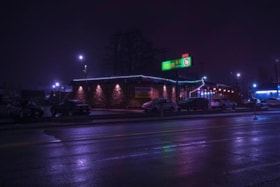
- Photograph of the exterior of the On On Wonton House restaurant, located at 5640 Kingsway. The photograph is taken from across Kingsway at night. The building, which was constructed in 1959, is lit up with lights and a bright sign, and several cars are parked in the lot in front of the restaurant.
- Repository
- City of Burnaby Archives
- Date
- 2022
- Collection/Fonds
- Disappearing Burnaby collection
- Physical Description
- 1 photograph (jpeg) : col.
- Description Level
- Item
- Record No.
- 634-017
- Access Restriction
- No restrictions
- Reproduction Restriction
- No restrictions
- Accession Number
- 2022-14
- Scope and Content
- Photograph of the exterior of the On On Wonton House restaurant, located at 5640 Kingsway. The photograph is taken from across Kingsway at night. The building, which was constructed in 1959, is lit up with lights and a bright sign, and several cars are parked in the lot in front of the restaurant.
- Media Type
- Photograph
- Photographer
- Cheung, Nakita
- Notes
- Title taken from the associated blog post
- Associated blog post: https://disappearingburnaby.wordpress.com/2022/06/06/on-on-wonton-house/
- Geographic Access
- Kingsway
- Street Address
- 5640 Kingsway
- Historic Neighbourhood
- Central Park (Historic Neighbourhood)
- Planning Study Area
- Windsor Area
Images
3700 Block East Hastings
https://search.heritageburnaby.ca/link/archivedescription97623
- Repository
- City of Burnaby Archives
- Date
- [196-]
- Collection/Fonds
- Burnaby Historical Society fonds
- Description Level
- Item
- Physical Description
- 1 photograph : b&w negative
- Scope and Content
- Photograph of the commercial properties located on the south side of the 3700 block of East Hastings Street. Businesses on the block include the Admiral Decorating Supply and the Trader.
- Repository
- City of Burnaby Archives
- Date
- [196-]
- Collection/Fonds
- Burnaby Historical Society fonds
- Subseries
- Municipal record subseries
- Physical Description
- 1 photograph : b&w negative
- Description Level
- Item
- Record No.
- 366-038
- Access Restriction
- No restrictions
- Reproduction Restriction
- Reproduce for fair dealing purposes only
- Accession Number
- BHS1998-12
- Scope and Content
- Photograph of the commercial properties located on the south side of the 3700 block of East Hastings Street. Businesses on the block include the Admiral Decorating Supply and the Trader.
- Subjects
- Buildings - Commercial - Stores
- Media Type
- Photograph
- Notes
- Title based on content of photograph
- Geographic Access
- Hastings Street
- Street Address
- 3700 Hastings Street
- Historic Neighbourhood
- Vancouver Heights (Historic Neighbourhood)
- Planning Study Area
- Burnaby Heights Area
Images
3800 Block East Hastings
https://search.heritageburnaby.ca/link/archivedescription97624
- Repository
- City of Burnaby Archives
- Date
- [196-]
- Collection/Fonds
- Burnaby Historical Society fonds
- Description Level
- Item
- Physical Description
- 1 photograph : b&w negative
- Scope and Content
- Photograph of the commercial properties located on the 3800 block of East Hastings Street. The sign for Halliwell's Shoe Repair at 3818 East Hastings Street is visible in the background. The photograph is taken from a low vantage point on Hastings Street, facing east.
- Repository
- City of Burnaby Archives
- Date
- [196-]
- Collection/Fonds
- Burnaby Historical Society fonds
- Subseries
- Municipal record subseries
- Physical Description
- 1 photograph : b&w negative
- Description Level
- Item
- Record No.
- 366-039
- Access Restriction
- No restrictions
- Reproduction Restriction
- Reproduce for fair dealing purposes only
- Accession Number
- BHS1998-12
- Scope and Content
- Photograph of the commercial properties located on the 3800 block of East Hastings Street. The sign for Halliwell's Shoe Repair at 3818 East Hastings Street is visible in the background. The photograph is taken from a low vantage point on Hastings Street, facing east.
- Subjects
- Buildings - Commercial - Stores
- Media Type
- Photograph
- Notes
- Title based on content of photograph
- Geographic Access
- Hastings Street
- Historic Neighbourhood
- Vancouver Heights (Historic Neighbourhood)
- Planning Study Area
- Burnaby Heights Area
Images
3900 Block East Hastings businesses
https://search.heritageburnaby.ca/link/archivedescription97616
- Repository
- City of Burnaby Archives
- Date
- [196-]
- Collection/Fonds
- Burnaby Historical Society fonds
- Description Level
- Item
- Physical Description
- 1 photograph : b&w negative
- Scope and Content
- Photograph of the businesses along the north side of the 3900 block of East Hastings Street. Signs for the National Bakery at 3918 East Hastings and Tobin's Quality Shoes at 3972 East Hastings are visible. Photograph taken from the north side of Hastings facing west.
- Repository
- City of Burnaby Archives
- Date
- [196-]
- Collection/Fonds
- Burnaby Historical Society fonds
- Subseries
- Municipal record subseries
- Physical Description
- 1 photograph : b&w negative
- Description Level
- Item
- Record No.
- 366-031
- Access Restriction
- No restrictions
- Reproduction Restriction
- Reproduce for fair dealing purposes only
- Accession Number
- BHS1998-12
- Scope and Content
- Photograph of the businesses along the north side of the 3900 block of East Hastings Street. Signs for the National Bakery at 3918 East Hastings and Tobin's Quality Shoes at 3972 East Hastings are visible. Photograph taken from the north side of Hastings facing west.
- Subjects
- Buildings - Commercial - Stores
- Media Type
- Photograph
- Notes
- Title based on content of photograph
- Geographic Access
- Hastings Street
- Historic Neighbourhood
- Vancouver Heights (Historic Neighbourhood)
- Planning Study Area
- Burnaby Heights Area
Images
3900 Block East Hastings Street
https://search.heritageburnaby.ca/link/archivedescription97618
- Repository
- City of Burnaby Archives
- Date
- [196-]
- Collection/Fonds
- Burnaby Historical Society fonds
- Description Level
- File
- Physical Description
- 3 photograph : b&w negatives
- Scope and Content
- Photographs of the rears of the businesses located along the 3900 block of East Hastings Street.
- Repository
- City of Burnaby Archives
- Date
- [196-]
- Collection/Fonds
- Burnaby Historical Society fonds
- Subseries
- Municipal record subseries
- Physical Description
- 3 photograph : b&w negatives
- Description Level
- File
- Record No.
- 366-033
- Access Restriction
- No restrictions
- Reproduction Restriction
- Reproduce for fair dealing purposes only
- Accession Number
- BHS1998-12
- Scope and Content
- Photographs of the rears of the businesses located along the 3900 block of East Hastings Street.
- Subjects
- Buildings - Commercial - Stores
- Media Type
- Photograph
- Notes
- Title based on content of photographs
- Geographic Access
- Hastings Street
- Historic Neighbourhood
- Vancouver Heights (Historic Neighbourhood)
- Planning Study Area
- Burnaby Heights Area
Images
3900 Hastings Street
https://search.heritageburnaby.ca/link/archivedescription37381
- Repository
- City of Burnaby Archives
- Date
- [between 1965 and 1970]
- Collection/Fonds
- Burnaby Historical Society fonds
- Description Level
- Item
- Physical Description
- 1 photograph : b&w negative
- Scope and Content
- Photograph taken looking west along Hastings Street, in front of the 3900 Block.
- Repository
- City of Burnaby Archives
- Date
- [between 1965 and 1970]
- Collection/Fonds
- Burnaby Historical Society fonds
- Subseries
- Municipal record subseries
- Physical Description
- 1 photograph : b&w negative
- Description Level
- Item
- Record No.
- 366-010
- Access Restriction
- No restrictions
- Reproduction Restriction
- Reproduce for fair dealing purposes only
- Accession Number
- BHS1998-12
- Scope and Content
- Photograph taken looking west along Hastings Street, in front of the 3900 Block.
- Media Type
- Photograph
- Notes
- Title based on contents of photograph
- Geographic Access
- Hastings Street
- Historic Neighbourhood
- Vancouver Heights (Historic Neighbourhood)
- Planning Study Area
- Burnaby Heights Area
Images
3901 Hastings Street
https://search.heritageburnaby.ca/link/archivedescription37382
- Repository
- City of Burnaby Archives
- Date
- [between 1965 and 1970]
- Collection/Fonds
- Burnaby Historical Society fonds
- Description Level
- Item
- Physical Description
- 1 photograph : b&w negative
- Scope and Content
- Photograph of the storefront at 3901 Hastings Street. A "for sale" sign is visible in the window.
- Repository
- City of Burnaby Archives
- Date
- [between 1965 and 1970]
- Collection/Fonds
- Burnaby Historical Society fonds
- Subseries
- Municipal record subseries
- Physical Description
- 1 photograph : b&w negative
- Description Level
- Item
- Record No.
- 366-011
- Access Restriction
- No restrictions
- Reproduction Restriction
- Reproduce for fair dealing purposes only
- Accession Number
- BHS1998-12
- Scope and Content
- Photograph of the storefront at 3901 Hastings Street. A "for sale" sign is visible in the window.
- Subjects
- Buildings - Commercial - Stores
- Media Type
- Photograph
- Notes
- Title based on contents of photograph.
- Geographic Access
- Hastings Street
- Street Address
- 3901 Hastings Street
- Historic Neighbourhood
- Vancouver Heights (Historic Neighbourhood)
- Planning Study Area
- Burnaby Heights Area
Images
3951 and 3953 Hastings Street
https://search.heritageburnaby.ca/link/archivedescription37385
- Repository
- City of Burnaby Archives
- Date
- [1965]
- Collection/Fonds
- Burnaby Historical Society fonds
- Description Level
- Item
- Physical Description
- 1 photograph : b&w negative
- Scope and Content
- Photograph of the buildings at 3951 and 3953 Hastings Street. A number of business signs are visible including "Paulettes Beauty Salon" and "Norburn Secondhand Store."
- Repository
- City of Burnaby Archives
- Date
- [1965]
- Collection/Fonds
- Burnaby Historical Society fonds
- Subseries
- Municipal record subseries
- Physical Description
- 1 photograph : b&w negative
- Description Level
- Item
- Record No.
- 366-014
- Access Restriction
- No restrictions
- Reproduction Restriction
- Reproduce for fair dealing purposes only
- Accession Number
- BHS1998-12
- Scope and Content
- Photograph of the buildings at 3951 and 3953 Hastings Street. A number of business signs are visible including "Paulettes Beauty Salon" and "Norburn Secondhand Store."
- Media Type
- Photograph
- Notes
- Title based on contents of photograph
- Geographic Access
- Hastings Street
- Street Address
- 3953 Hastings Street
- 3951 Hastings Street
- Historic Neighbourhood
- Vancouver Heights (Historic Neighbourhood)
- Planning Study Area
- Burnaby Heights Area
Images
Brentwood
https://search.heritageburnaby.ca/link/archivedescription51415
- Repository
- City of Burnaby Archives
- Date
- 1966
- Collection/Fonds
- Harold H. Johnston fonds
- Description Level
- Item
- Physical Description
- 1 photograph (jpeg) : b&w
- Scope and Content
- Photograph is a panoramic view of the Brentwood Shopping Centre, taken from the parking lot.
- Repository
- City of Burnaby Archives
- Date
- 1966
- Collection/Fonds
- Harold H. Johnston fonds
- Physical Description
- 1 photograph (jpeg) : b&w
- Description Level
- Item
- Record No.
- 483-049
- Access Restriction
- No restrictions
- Reproduction Restriction
- No reproduction permitted
- Accession Number
- 2008-08
- Scope and Content
- Photograph is a panoramic view of the Brentwood Shopping Centre, taken from the parking lot.
- Media Type
- Photograph
- Photographer
- Johnston, Harold H.
- Notes
- Title based on contents of photograph
- Geographic Access
- Lougheed Highway
- Street Address
- 4567 Lougheed Highway
- Planning Study Area
- Brentwood Area
Images
Brentwood Shopping Centre
https://search.heritageburnaby.ca/link/archivedescription35132
- Repository
- City of Burnaby Archives
- Date
- [196-]
- Collection/Fonds
- Burnaby Historical Society fonds
- Description Level
- Item
- Physical Description
- 1 photograph : col. postcard ; 8.9 x 14.0 cm
- Scope and Content
- Postcard cosisting of four photographs of Brentwood Shopping Centre. The description printed on the back of the postcard reads, "Brentwood Shopping Centre / Lougheed and Willingdon, Burnaby, B.C. Free parking for 2500 cars. Eaton's of Canada - three floors of air-conditioned shopping comfort. Fo…
- Repository
- City of Burnaby Archives
- Date
- [196-]
- Collection/Fonds
- Burnaby Historical Society fonds
- Subseries
- Evelyn Salisbury subseries
- Physical Description
- 1 photograph : col. postcard ; 8.9 x 14.0 cm
- Description Level
- Item
- Record No.
- 195-002
- Access Restriction
- No restrictions
- Reproduction Restriction
- Reproduce for fair dealing purposes only
- Accession Number
- BHS1987-04
- Scope and Content
- Postcard cosisting of four photographs of Brentwood Shopping Centre. The description printed on the back of the postcard reads, "Brentwood Shopping Centre / Lougheed and Willingdon, Burnaby, B.C. Free parking for 2500 cars. Eaton's of Canada - three floors of air-conditioned shopping comfort. Fountain Square. Loblaw's ... B.C.'s Largest Supermarket." The cost to mail the postcard is listed as four cents. Some of the stores visible are: Bank of Montreal, Heywood Floors, The Doll House Restaurant, Eaton's of Canada, Loblaws, Fields, and Zeller's.
- Subjects
- Geographic Features - Automobile Parking Lots
- Fountains
- Documentary Artifacts - Postcards
- Buildings - Commercial - Malls
- Media Type
- Photograph
- Photographer
- Ford, Rolly
- Notes
- Title based on contents of photograph
- Geographic Access
- Lougheed Highway
- Street Address
- 4567 Lougheed Highway
- Planning Study Area
- Brentwood Area
Images
Burnaby Historical Society float
https://search.heritageburnaby.ca/link/archivedescription34656
- Repository
- City of Burnaby Archives
- Date
- [196-]
- Collection/Fonds
- Burnaby Historical Society fonds
- Description Level
- Item
- Physical Description
- 1 photograph : b&w ; 12.3 x 17.7 cm
- Scope and Content
- Photograph of the Burnaby Historical Society float in the Pacific National Exhibition's parade on Hastings Street. The float is decorated as Interurban Tram no. 1223. Written on the tram roof is, XXX"Burnaby Historical Society," on the side is "The Last Tram," and on the back is "Burnaby / 1223."…
- Repository
- City of Burnaby Archives
- Date
- [196-]
- Collection/Fonds
- Burnaby Historical Society fonds
- Subseries
- Photographs subseries
- Physical Description
- 1 photograph : b&w ; 12.3 x 17.7 cm
- Description Level
- Item
- Record No.
- 081-004
- Access Restriction
- No restrictions
- Reproduction Restriction
- Reproduce for fair dealing purposes only
- Accession Number
- BHS2007-04
- Scope and Content
- Photograph of the Burnaby Historical Society float in the Pacific National Exhibition's parade on Hastings Street. The float is decorated as Interurban Tram no. 1223. Written on the tram roof is, XXX"Burnaby Historical Society," on the side is "The Last Tram," and on the back is "Burnaby / 1223." Behind the float are two men seated in an old car with a sign reading, "The Hydro Originals" on the side. The stores that can be seen are: Bank of Montreal, Royal Bank of Canada, Ward Music, Hans Grumme Hairstylists, Susie Wong Fashions, and Canadian Pacific Telegrams. A bus stop sign for Main, Hastings, unidentified, Oak, and Victoria buses can also be seen.
- Media Type
- Photograph
- Notes
- Title based on contents of photograph
Images
Cash till line up
https://search.heritageburnaby.ca/link/archivedescription95107
- Repository
- City of Burnaby Archives
- Date
- April 27, 2020
- Collection/Fonds
- Burnaby Photographic Society fonds
- Description Level
- Item
- Physical Description
- 1 photograph (tiff)
- Scope and Content
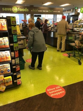
- Photograph of shoppers in the checkout lines at Save-On-Foods grocery store at the Old Orchard Shopping Centre. On the floor are red decals indicating where shoppers should stand to maintain distance from one another. The decals read: "Allow 2M between shoppers".
- Repository
- City of Burnaby Archives
- Date
- April 27, 2020
- Collection/Fonds
- Burnaby Photographic Society fonds
- Physical Description
- 1 photograph (tiff)
- Description Level
- Item
- Record No.
- 623-025
- Access Restriction
- No restrictions
- Reproduction Restriction
- No restrictions
- Accession Number
- 2020-10
- Scope and Content
- Photograph of shoppers in the checkout lines at Save-On-Foods grocery store at the Old Orchard Shopping Centre. On the floor are red decals indicating where shoppers should stand to maintain distance from one another. The decals read: "Allow 2M between shoppers".
- Media Type
- Photograph
- Photographer
- Snowdon, Nick
- Notes
- Transcribed title
- Photographer's caption: "Physical distancing signs become common in most stores"
- Geographic Access
- Kingsway
- Street Address
- 4429 Kingsway
- Historic Neighbourhood
- Central Park (Historic Neighbourhood)
- Planning Study Area
- Garden Village Area
Images
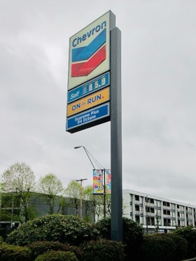
Cheap Gas during Covid Pandemic
https://search.heritageburnaby.ca/link/archivedescription95087
- Repository
- City of Burnaby Archives
- Date
- April 27, 2020
- Collection/Fonds
- Burnaby Photographic Society fonds
- Description Level
- Item
- Physical Description
- 1 photograph (tiff)
- Scope and Content
- Photograph of a Chevron Gas Station sign advertising gas for 85.9 cents per litre. The Chevron station is located at 6138 Kingsway.
- Repository
- City of Burnaby Archives
- Date
- April 27, 2020
- Collection/Fonds
- Burnaby Photographic Society fonds
- Physical Description
- 1 photograph (tiff)
- Description Level
- Item
- Record No.
- 623-006
- Access Restriction
- No restrictions
- Reproduction Restriction
- Reproduce for fair dealing purposes only
- Accession Number
- 2020-10
- Scope and Content
- Photograph of a Chevron Gas Station sign advertising gas for 85.9 cents per litre. The Chevron station is located at 6138 Kingsway.
- Media Type
- Photograph
- Photographer
- Asbia, Cher
- Notes
- Transcribed title
- Photographer's caption: "Huge drop in gas prices for a few weeks only"
- Geographic Access
- Kingsway
- Street Address
- 6138 Kingsway
- Planning Study Area
- Clinton-Glenwood Area
Images
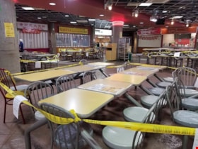
Crystal Mall
https://search.heritageburnaby.ca/link/archivedescription95119
- Repository
- City of Burnaby Archives
- Date
- March 25, 2020
- Collection/Fonds
- Burnaby Photographic Society fonds
- Description Level
- Item
- Physical Description
- 1 photograph (tiff)
- Scope and Content
- Photograph of an empty food court at Crystal Mall. All tables are closed off with caution tape and the restaurants are closed.
- Repository
- City of Burnaby Archives
- Date
- March 25, 2020
- Collection/Fonds
- Burnaby Photographic Society fonds
- Physical Description
- 1 photograph (tiff)
- Description Level
- Item
- Record No.
- 623-037
- Access Restriction
- No restrictions
- Reproduction Restriction
- No restrictions
- Accession Number
- 2020-10
- Scope and Content
- Photograph of an empty food court at Crystal Mall. All tables are closed off with caution tape and the restaurants are closed.
- Subjects
- Buildings - Commercial - Malls
- Media Type
- Photograph
- Photographer
- Cheung, Ray
- Notes
- Transcribed title
- Geographic Access
- Kingsway
- Street Address
- 4500 Kingsway
- Historic Neighbourhood
- Central Park (Historic Neighbourhood)
- Planning Study Area
- Maywood Area
Images
Dennis Krewenchuk
https://search.heritageburnaby.ca/link/archivedescription88419
- Repository
- City of Burnaby Archives
- Date
- [1960 or 1961]
- Collection/Fonds
- Krewenchuk family fonds
- Description Level
- Item
- Physical Description
- 1 photograph : b&w ; 10.5 x 7.5 cm
- Scope and Content
- Photograph of Dennis Krewenchuk standing outside cabin number eight at the Nelson Auto Court located at 6550 Nelson Avenue. Dennis' parents, Mike and Mary Krewenchuk owned and operated and lived at the Nelson Auto Court from 1957 to 1967.
- Repository
- City of Burnaby Archives
- Date
- [1960 or 1961]
- Collection/Fonds
- Krewenchuk family fonds
- Physical Description
- 1 photograph : b&w ; 10.5 x 7.5 cm
- Description Level
- Item
- Record No.
- 582-008
- Access Restriction
- No restrictions
- Reproduction Restriction
- Reproduce for fair dealing purposes only
- Accession Number
- 2015-05
- Scope and Content
- Photograph of Dennis Krewenchuk standing outside cabin number eight at the Nelson Auto Court located at 6550 Nelson Avenue. Dennis' parents, Mike and Mary Krewenchuk owned and operated and lived at the Nelson Auto Court from 1957 to 1967.
- Names
- Krewenchuk, Dennis
- Media Type
- Photograph
- Notes
- Title based on contents of photograph
- Street Address
- 6550 Nelson Avenue
- Historic Neighbourhood
- Central Park (Historic Neighbourhood)
- Planning Study Area
- Windsor Area
Images
East Hastings Street
https://search.heritageburnaby.ca/link/archivedescription97620
- Repository
- City of Burnaby Archives
- Date
- [196-]
- Collection/Fonds
- Burnaby Historical Society fonds
- Description Level
- File
- Physical Description
- 2 photographs : b&w negatives
- Scope and Content
- Photographs of an unidentified commercial block of East Hastings Street in Burnaby. Businesses are visible in the background of the photo, featuring signs for a barbershop, grocery store, and tailoring business
- Repository
- City of Burnaby Archives
- Date
- [196-]
- Collection/Fonds
- Burnaby Historical Society fonds
- Subseries
- Municipal record subseries
- Physical Description
- 2 photographs : b&w negatives
- Description Level
- File
- Record No.
- 366-035
- Access Restriction
- No restrictions
- Reproduction Restriction
- Reproduce for fair dealing purposes only
- Accession Number
- BHS1998-12
- Scope and Content
- Photographs of an unidentified commercial block of East Hastings Street in Burnaby. Businesses are visible in the background of the photo, featuring signs for a barbershop, grocery store, and tailoring business
- Subjects
- Buildings - Commercial - Stores
- Media Type
- Photograph
- Notes
- Title based on content of photographs
- Geographic Access
- Hastings Street
- Historic Neighbourhood
- Vancouver Heights (Historic Neighbourhood)
- Planning Study Area
- Burnaby Heights Area

![Hazel (Bongea) Padula standing on the steps of her home at High Lawn, [195-]. Item no. 549-052. thumbnail](/media/hpo/_Data/_Archives_Images/_Unrestricted/540/549-052.jpg?width=280)
![3700 Block East Hastings, [196-] thumbnail](/media/hpo/_Data/_Archives_Images/_Unrestricted/316/366-038.jpg?width=280)
![3800 Block East Hastings, [196-] thumbnail](/media/hpo/_Data/_Archives_Images/_Unrestricted/316/366-039.jpg?width=280)
![3900 Block East Hastings businesses, [196-] thumbnail](/media/hpo/_Data/_Archives_Images/_Unrestricted/316/366-031.jpg?width=280)
![3900 Block East Hastings Street, [196-] thumbnail](/media/hpo/_Data/_Archives_Images/_Unrestricted/316/366-033-3.jpg?width=280)
![3900 Hastings Street, [between 1965 and 1970] thumbnail](/media/hpo/_Data/_Archives_Images/_Unrestricted/316/366-010.jpg?width=280)
![3901 Hastings Street, [between 1965 and 1970] thumbnail](/media/hpo/_Data/_Archives_Images/_Unrestricted/316/366-011.jpg?width=280)
![3951 and 3953 Hastings Street, [1965] thumbnail](/media/hpo/_Data/_Archives_Images/_Unrestricted/316/366-014.jpg?width=280)

![Brentwood Shopping Centre, [196-] thumbnail](/media/hpo/_Data/_Archives_Images/_Unrestricted/126/195-002.jpg?width=280)
![Burnaby Historical Society float, [196-] thumbnail](/media/hpo/_Data/_Archives_Images/_Unrestricted/001/081-004.jpg?width=280)
![Dennis Krewenchuk, [1960 or 1961] thumbnail](/media/hpo/_Data/_Archives_Images/_Unrestricted/580/582-008.jpg?width=280)
![East Hastings Street, [196-] thumbnail](/media/hpo/_Data/_Archives_Images/_Unrestricted/316/366-035-1.jpg?width=280)