More like 'Alfred Bingham's writings - Track 6'
Narrow Results By
Decade
- 2020s 93
- 2010s 59
- 2000s 603
- 1990s
- 1980s 441
- 1970s 867
- 1960s 468
- 1950s
- 1940s 496
- 1930s 435
- 1920s 599
- 1910s 471
- 1900s 175
- 1890s 23
- 1880s 49
- 1870s
- 1860s 1
- 1850s 1
- 1840s 1
- 1830s 1
- 1820s 1
- 1810s 1
- 1800s 1
- 1790s 1
- 1780s 1
- 1770s 1
- 1760s 1
- 1750s 1
- 1740s 1
- 1730s 1
- 1720s 1
- 1710s 1
- 1700s 1
- 1690s 1
- 1680s 1
- 1670s 1
- 1660s 1
- 1650s 1
- 1640s 1
- 1630s 1
- 1620s 1
- 1610s 1
- 1600s 1
Creator
- Aero Surveys Limited 1
- Allan Studios 3
- Associated Factory Mutual Fire Insurance Cos 1
- Atwood, Patricia 1
- Baden-Powell of Gilwell, Robert Stephenson Smyth Baden-Powell, Baron, 1857-1941 1
- Bartel, Mario 27
- Bate, May 1
- Baume, Y. S. 1
- Binks, James 6
- Blissett, Rebecca 3
- Bower, Ralph 1
- Burnaby Village Museum 28
5324 Thorne Ave
https://search.heritageburnaby.ca/link/archivedescription93762
- Repository
- City of Burnaby Archives
- Date
- June 12, 1992
- Collection/Fonds
- Grover, Elliott & Co. Ltd. fonds
- Description Level
- File
- Physical Description
- 120 photographs : col. negatives ; 35 mm
- Scope and Content
- Photographs of an industrial property located at 5324 Thorne Avenue - an address than no longer exists.
- Repository
- City of Burnaby Archives
- Date
- June 12, 1992
- Collection/Fonds
- Grover, Elliott & Co. Ltd. fonds
- Physical Description
- 120 photographs : col. negatives ; 35 mm
- Description Level
- File
- Record No.
- 622-047
- Access Restriction
- No restrictions
- Reproduction Restriction
- No restrictions
- Accession Number
- 2017-39
- Scope and Content
- Photographs of an industrial property located at 5324 Thorne Avenue - an address than no longer exists.
- Subjects
- Buildings - Industrial
- Media Type
- Photograph
- Notes
- Transcribed title
- Title transcribed from envelope photographs were originally housed in
- File no. 92-224-I
- Note adhered to 622-047-001 print reads: "11 / The manufacturing plant [illegible], southwest from the northweast corner of the site".
- Note adhered to 622-047-5 print reads: "17 / view south along the east side of the property from Thorne Avenue".
- Note adhered to 622-047-9 print reads: "18 / The canopy at loading area and shed addition of the [illegible] and of the building".
- Note adhered to 622-047-13 print reads: "19 / View of the interior of the building looking towards to west".
- Note adhered to 622-047-17 print reads: "23 / view east across the site immediately south of the building".
- Note adhered to 622-047-21 print reads: "22 / view looking north west twoards the south facade".
- Note adhered to 622-047-25 print reads: "8 / The freestanding office building adjacent to Thorne Avenue and Wiggins Street".
- Note adhered to 622-047-29 print reads: "9 / View of its front entr [sid] and the office building".
- Note adhered to 622-047-33 reads: "10 / View west towards the office building from the main vehicle entr [sic] at Thorne Avenue".
- Note adhered to 622-047-37 print reads: "14 / View east across the north yard area".
- Note adhered to 622-047-41 print reads: "12 / View of the north facade looking south."
- Note adhered to 622-047-45 print reads: "13 / View west across the north yard area".
- Note adhered to 622-047-49 print reads: "20 / The [illegible] building".
- Note adhered to 622-047-53 print reads: "26 / View northeast from the west property line".
- Note adhered to 622-047-57 print reads: "21 / View looking northeast at the south facade".
- Note adhered to 622-047-61 print reads: "16 / View north along the west side of the manufacturing building".
- Note adhered to 622-047-65 print reads: "15 / View of the north west corner of the manufacturing building".
- Note adhered to 622-047-69 print reads: "3 / View west along Thorne Avenue from the east side of the property".
- Note adhered to 622-047-73 print reads: "25 / View north from the southeast corner of the property".
- Note adhered to 622-047-77 print reads: "30 / View of the dock looking southeast from the property".
- Note adhered to 622-047-81 print reads: "24 / View north from the southwest corner of the property".
- Note adhered to 622-047-85 print reads: "27 / The barge dock at the southwest corner of the site".
- Note adhered to 622-047-89 print reads: "29 / View east along the river front".
- Note adhered to 622-047-93 print reads: "28 / View of the dolphins and mooring area".
- Note adhered to 622-047-97 print reads: "4 / View west along [illegible] Avenue past the entrance to the north parking lot".
- Note adhered to 622-047-101 print reads: "2 / View southwest from Thorne Avenue".
- Note adhered to 622-047-105 print reads: "5 / View west across the north parking lot".
- Note adhered to 622-047-113 print reads: "6 / View southeast from the north parking lot".
- Photographer identified as "D.E."
- Geographic Access
- Thorne Avenue
- Historic Neighbourhood
- Fraser Arm (Historic Neighbourhood)
- Planning Study Area
- Big Bend Area
6501 Sprott St
https://search.heritageburnaby.ca/link/archivedescription93771
- Repository
- City of Burnaby Archives
- Date
- September 1992
- Collection/Fonds
- Grover, Elliott & Co. Ltd. fonds
- Description Level
- File
- Physical Description
- 48 photographs : col. negatives ; 35 mm
- Scope and Content
- Photographs of the industrial property located at 6501 Sprott Street, which includestwo buildings and a parking lot.
- Repository
- City of Burnaby Archives
- Date
- September 1992
- Collection/Fonds
- Grover, Elliott & Co. Ltd. fonds
- Physical Description
- 48 photographs : col. negatives ; 35 mm
- Description Level
- File
- Record No.
- 622-055
- Access Restriction
- No restrictions
- Reproduction Restriction
- No restrictions
- Accession Number
- 2017-39
- Scope and Content
- Photographs of the industrial property located at 6501 Sprott Street, which includestwo buildings and a parking lot.
- Subjects
- Buildings - Industrial
- Media Type
- Photograph
- Notes
- Transcribed title
- Title transcribed from envelope photographs were originally housed in
- File no. 92-327-B
- Photographer identified as "D.C."
- Geographic Access
- Sprott Street
- Street Address
- 6501 Sprott Street
- Historic Neighbourhood
- Burnaby Lake (Historic Neighbourhood)
- Planning Study Area
- Ardingley-Sprott Area
6741 Cariboo Rd Burnaby
https://search.heritageburnaby.ca/link/archivedescription94308
- Repository
- City of Burnaby Archives
- Date
- April 1994
- Collection/Fonds
- Grover, Elliott & Co. Ltd. fonds
- Description Level
- File
- Physical Description
- 25 photographs : col. negatives ; 35 mm
- Scope and Content
- Photographs of an undeveloped property, single-storey industrial building, and railroad crossing.
- Repository
- City of Burnaby Archives
- Date
- April 1994
- Collection/Fonds
- Grover, Elliott & Co. Ltd. fonds
- Physical Description
- 25 photographs : col. negatives ; 35 mm
- Description Level
- File
- Record No.
- 622-093
- Access Restriction
- No restrictions
- Reproduction Restriction
- No restrictions
- Accession Number
- 2017-39
- Scope and Content
- Photographs of an undeveloped property, single-storey industrial building, and railroad crossing.
- Media Type
- Photograph
- Photographer
- Young, Richard
- Notes
- Transcribed title
- Title transcribed from envelope photographs were originally housed in
- File no. 94-115-B
- Geographic Access
- Cariboo Road
- Street Address
- 6741 Cariboo Road
- Planning Study Area
- Burnaby Lake Area
7050 Buller Ave
https://search.heritageburnaby.ca/link/archivedescription93884
- Repository
- City of Burnaby Archives
- Date
- March 1993
- Collection/Fonds
- Grover, Elliott & Co. Ltd. fonds
- Description Level
- File
- Physical Description
- 25 photographs : col. negatives ; 35 mm
- Scope and Content
- Photographs of an industrial building located at 7050 Buller Avenue taken from Buller Avenue and Beresford Street.
- Repository
- City of Burnaby Archives
- Date
- March 1993
- Collection/Fonds
- Grover, Elliott & Co. Ltd. fonds
- Physical Description
- 25 photographs : col. negatives ; 35 mm
- Description Level
- File
- Record No.
- 622-067
- Access Restriction
- No restrictions
- Reproduction Restriction
- No restrictions
- Accession Number
- 2017-39
- Scope and Content
- Photographs of an industrial building located at 7050 Buller Avenue taken from Buller Avenue and Beresford Street.
- Media Type
- Photograph
- Photographer
- Young, Richard
- Notes
- Transcribed title
- Title transcribed from envelope photographs were originally housed in
- File no. 93-109-B
- Geographic Access
- Buller Avenue
- Beresford Street
- Street Address
- 7050 Buller Avenue
- Planning Study Area
- Windsor Area
7260 Winston St.
https://search.heritageburnaby.ca/link/archivedescription94312
- Repository
- City of Burnaby Archives
- Date
- June 1994
- Collection/Fonds
- Grover, Elliott & Co. Ltd. fonds
- Description Level
- File
- Physical Description
- 49 photographs : col. negatives ; 35 mm
- Scope and Content
- Photographs of the exterior of Unisource, located at 7260 Winston Street.
- Repository
- City of Burnaby Archives
- Date
- June 1994
- Collection/Fonds
- Grover, Elliott & Co. Ltd. fonds
- Physical Description
- 49 photographs : col. negatives ; 35 mm
- Description Level
- File
- Record No.
- 622-097
- Access Restriction
- No restrictions
- Reproduction Restriction
- No restrictions
- Accession Number
- 2017-39
- Scope and Content
- Photographs of the exterior of Unisource, located at 7260 Winston Street.
- Subjects
- Buildings - Industrial
- Media Type
- Photograph
- Notes
- Transcribed title
- Title transcribed from envelope photographs were originally housed in
- File no. 94-214-B
- Photographer identified as "K.H."
- Geographic Access
- Winston Street
- Street Address
- 7260 Winston Street
- Historic Neighbourhood
- Lozells (Historic Neighbourhood)
- Planning Study Area
- Government Road Area
![B.C. Electric Company, [1958] thumbnail](/media/Hpo/_Data/_Archives_Images/_Unrestricted/001/100-001.jpg?width=280)
B.C. Electric Company
https://search.heritageburnaby.ca/link/archivedescription34691
- Repository
- City of Burnaby Archives
- Date
- [1958]
- Collection/Fonds
- Burnaby Historical Society fonds
- Description Level
- Item
- Physical Description
- 1 photograph : b&w ; 20.2 x 25.6 cm
- Scope and Content
- Photograph of the exterior of the B.C. Electric Co. gas distribution centre building.
- Repository
- City of Burnaby Archives
- Date
- [1958]
- Collection/Fonds
- Burnaby Historical Society fonds
- Subseries
- Photographs subseries
- Physical Description
- 1 photograph : b&w ; 20.2 x 25.6 cm
- Description Level
- Item
- Record No.
- 100-001
- Access Restriction
- No restrictions
- Reproduction Restriction
- Reproduce for fair dealing purposes only
- Accession Number
- BHS2007-04
- Scope and Content
- Photograph of the exterior of the B.C. Electric Co. gas distribution centre building.
- Subjects
- Buildings - Industrial
- Media Type
- Photograph
- Photographer
- Graphic Industries Limited
- Notes
- Title based on contents of photograph
- Printed at bottom right front of photo, "B.C. Electric"
- Stamp on back of photo reads, "Photo by Graphic Industries Ltd. / File No. 4383 / Vancouver, Canada / MUtual 1-4174"
Images
![B.C. Electric Company, [1958] thumbnail](/media/Hpo/_Data/_Archives_Images/_Unrestricted/001/100-001.jpg)
![Blacksmith shops, [194-?] (date of originals), copied [1971] thumbnail](/media/hpo/_Data/_BVM_Images/2000/200000180008.jpg?width=280)
Blacksmith shops
https://search.heritageburnaby.ca/link/museumdescription1947
- Repository
- Burnaby Village Museum
- Date
- [194-?] (date of originals), copied [1971]
- Collection/Fonds
- Burnaby Centennial '71 Committee collection
- Description Level
- Item
- Physical Description
- 1 photograph : b&w composite ; 26 x 30.5 cm, mounted on cardboard 32 x 39 cm
- Scope and Content
- Composite photograph of various aspects of unidentified blacksmith shops including interiors, equipment and exteriors.
- Repository
- Burnaby Village Museum
- Collection/Fonds
- Burnaby Centennial '71 Committee collection
- Description Level
- Item
- Physical Description
- 1 photograph : b&w composite ; 26 x 30.5 cm, mounted on cardboard 32 x 39 cm
- Material Details
- Composite is comprised of ten photographs
- Scope and Content
- Composite photograph of various aspects of unidentified blacksmith shops including interiors, equipment and exteriors.
- Names
- Burnaby Village Museum
- Accession Code
- BV000.18.8
- Access Restriction
- Restricted access
- Reproduction Restriction
- May be restricted by third party rights
- Date
- [194-?] (date of originals), copied [1971]
- Media Type
- Photograph
- Arrangement
- Record appears to be a part of the Burnaby Centennial Committee or the Century Park Museum Associaton. Jon Newby was a board member of either of these committees.
- Scan Resolution
- 600
- Scan Date
- 1/8/2010
- Scale
- 100
- Notes
- Title based on contents of photograph
Images
![Blacksmith shops, [194-?] (date of originals), copied [1971] thumbnail](/media/hpo/_Data/_BVM_Images/2000/200000180008.jpg)
![Brantford Coach and Body Ltd., [1959] thumbnail](/media/hpo/_Data/_Archives_Images/_Unrestricted/001/076-001.jpg?width=280)
Brantford Coach and Body Ltd.
https://search.heritageburnaby.ca/link/archivedescription34642
- Repository
- City of Burnaby Archives
- Date
- [1959]
- Collection/Fonds
- Burnaby Historical Society fonds
- Description Level
- Item
- Physical Description
- 1 photograph : b&w ; 20.5 x 25.7 cm
- Scope and Content
- Photograph of the exterior of Brantford Coach and Body Ltd. at 6055 Gilmore Avenue. Signs on the building show the business name and also read, "Sales" and "Service."
- Repository
- City of Burnaby Archives
- Date
- [1959]
- Collection/Fonds
- Burnaby Historical Society fonds
- Subseries
- Photographs subseries
- Physical Description
- 1 photograph : b&w ; 20.5 x 25.7 cm
- Description Level
- Item
- Record No.
- 076-001
- Access Restriction
- No restrictions
- Reproduction Restriction
- Reproduce for fair dealing purposes only
- Accession Number
- BHS2007-04
- Scope and Content
- Photograph of the exterior of Brantford Coach and Body Ltd. at 6055 Gilmore Avenue. Signs on the building show the business name and also read, "Sales" and "Service."
- Subjects
- Buildings - Industrial
- Media Type
- Photograph
- Notes
- Title based on contents of photograph
- Geographic Access
- Gilmore Avenue
- Street Address
- 6055 Gilmore Avenue
Images
![Brantford Coach and Body Ltd., [1959] thumbnail](/media/hpo/_Data/_Archives_Images/_Unrestricted/001/076-001.jpg)
Burnaby
https://search.heritageburnaby.ca/link/archivedescription93751
- Repository
- City of Burnaby Archives
- Date
- 1991
- Collection/Fonds
- Grover, Elliott & Co. Ltd. fonds
- Description Level
- File
- Physical Description
- 43 photographs : col. negatives ; 35 mm
- Scope and Content
- Photographs of the exterior of a single-storey industrial building and surrounding undeveloped property. A sign on the building reads "Bauer". The location of the building has not been identified.
- Repository
- City of Burnaby Archives
- Date
- 1991
- Collection/Fonds
- Grover, Elliott & Co. Ltd. fonds
- Physical Description
- 43 photographs : col. negatives ; 35 mm
- Description Level
- File
- Record No.
- 622-036
- Access Restriction
- No restrictions
- Reproduction Restriction
- No restrictions
- Accession Number
- 2017-39
- Scope and Content
- Photographs of the exterior of a single-storey industrial building and surrounding undeveloped property. A sign on the building reads "Bauer". The location of the building has not been identified.
- Subjects
- Buildings - Industrial
- Land Clearing
- Media Type
- Photograph
- Notes
- Transcribed title
- Title transcribed from envelope photographs were originally housed in
- File no. 91-452-B

Canadian Lead and Alloys Ltd.
https://search.heritageburnaby.ca/link/archivedescription34587
- Repository
- City of Burnaby Archives
- Date
- 1958
- Collection/Fonds
- Burnaby Historical Society fonds
- Description Level
- Item
- Physical Description
- 1 photograph : b&w ; 20.5 x 25.7 cm
- Scope and Content
- Photograph of the exterior of the Canadian Lead and Alloys Ltd. building at 2345 Douglas Road.
- Repository
- City of Burnaby Archives
- Date
- 1958
- Collection/Fonds
- Burnaby Historical Society fonds
- Subseries
- Photographs subseries
- Physical Description
- 1 photograph : b&w ; 20.5 x 25.7 cm
- Description Level
- Item
- Record No.
- 061-001
- Access Restriction
- No restrictions
- Reproduction Restriction
- Reproduce for fair dealing purposes only
- Accession Number
- BHS2007-04
- Scope and Content
- Photograph of the exterior of the Canadian Lead and Alloys Ltd. building at 2345 Douglas Road.
- Subjects
- Buildings - Industrial - Factories
- Media Type
- Photograph
- Notes
- Title based on contents of photograph
- Street Address
- 2345 Douglas Road
- Planning Study Area
- Dawson-Delta Area
Images

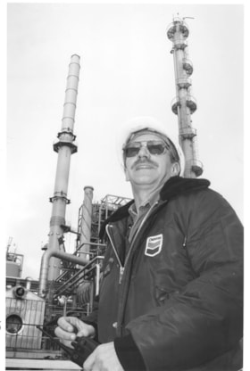
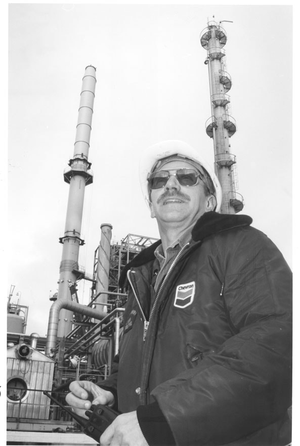
Chevron Refinery
https://search.heritageburnaby.ca/link/archivedescription79805
- Repository
- City of Burnaby Archives
- Date
- December 18, 1996
- Collection/Fonds
- Burnaby NewsLeader photograph collection
- Description Level
- Item
- Physical Description
- 1 photograph : b&w ; 22.5 x 15 cm
- Scope and Content
- Photograph of an unidentified man wearing a Chevron jacket and hard hat at the Chevron refinery.
- Repository
- City of Burnaby Archives
- Date
- December 18, 1996
- Collection/Fonds
- Burnaby NewsLeader photograph collection
- Physical Description
- 1 photograph : b&w ; 22.5 x 15 cm
- Description Level
- Item
- Record No.
- 535-0523
- Access Restriction
- No restrictions
- Reproduction Restriction
- No reproduction permitted
- Accession Number
- 2012-11
- Scope and Content
- Photograph of an unidentified man wearing a Chevron jacket and hard hat at the Chevron refinery.
- Subjects
- Buildings - Industrial - Refineries
- Media Type
- Photograph
- Photographer
- Langdeau, Brian
- Notes
- Title based on contents of photograph
- Note in black ink on recto of photograph reads: "72% Bby p. 15 / Brian 3123 Bby A"
- Trim marks and/or reproduction instructions on recto (scan is cropped)
- Man in photograph has been identified has Kenneth Leduc.
Images
![Dairy and Silos at Oakalla, [195-] (date of original), copied 1991 thumbnail](/media/hpo/_Data/_Archives_Images/_Unrestricted/370/370-716.jpg?width=280)
Dairy and Silos at Oakalla
https://search.heritageburnaby.ca/link/archivedescription38129
- Repository
- City of Burnaby Archives
- Date
- [195-] (date of original), copied 1991
- Collection/Fonds
- Burnaby Historical Society fonds
- Description Level
- Item
- Physical Description
- 1 photograph : b&w ; 3.0 x 4.3 cm print on contact sheet 19.8 x 26.2 cm
- Scope and Content
- Photograph of the exterior of the dairy and silos at Oakalla Prison Farm.
- Repository
- City of Burnaby Archives
- Date
- [195-] (date of original), copied 1991
- Collection/Fonds
- Burnaby Historical Society fonds
- Subseries
- Burnaby Image Bank subseries
- Physical Description
- 1 photograph : b&w ; 3.0 x 4.3 cm print on contact sheet 19.8 x 26.2 cm
- Description Level
- Item
- Record No.
- 370-716
- Access Restriction
- No restrictions
- Reproduction Restriction
- Reproduce for fair dealing purposes only
- Accession Number
- BHS1999-03
- Scope and Content
- Photograph of the exterior of the dairy and silos at Oakalla Prison Farm.
- Names
- Oakalla Prison Farm
- Media Type
- Photograph
- Notes
- Title based on contents of photograph
- 1 b&w copy negative accompanying
- Negative has a pink cast
- Geographic Access
- Oakmount Crescent
- Street Address
- 5220 Oakmount Crescent
- Historic Neighbourhood
- Burnaby Lake (Historic Neighbourhood)
- Planning Study Area
- Oakalla Area
Images
![Dairy and Silos at Oakalla, [195-] (date of original), copied 1991 thumbnail](/media/hpo/_Data/_Archives_Images/_Unrestricted/370/370-716.jpg)
![Dairy at Oakalla, [195-] (date of original), copied 1991 thumbnail](/media/hpo/_Data/_Archives_Images/_Unrestricted/370/370-710.jpg?width=280)
Dairy at Oakalla
https://search.heritageburnaby.ca/link/archivedescription38123
- Repository
- City of Burnaby Archives
- Date
- [195-] (date of original), copied 1991
- Collection/Fonds
- Burnaby Historical Society fonds
- Description Level
- Item
- Physical Description
- 1 photograph : b&w ; 2.9 x 4.1 cm print on contact sheet 20.1 x 26.5 cm
- Scope and Content
- Photograph of the exterior of the dairy at Oakalla Prison Farm.
- Repository
- City of Burnaby Archives
- Date
- [195-] (date of original), copied 1991
- Collection/Fonds
- Burnaby Historical Society fonds
- Subseries
- Burnaby Image Bank subseries
- Physical Description
- 1 photograph : b&w ; 2.9 x 4.1 cm print on contact sheet 20.1 x 26.5 cm
- Description Level
- Item
- Record No.
- 370-710
- Access Restriction
- No restrictions
- Reproduction Restriction
- Reproduce for fair dealing purposes only
- Accession Number
- BHS1999-03
- Scope and Content
- Photograph of the exterior of the dairy at Oakalla Prison Farm.
- Subjects
- Buildings - Industrial - Dairies
- Names
- Oakalla Prison Farm
- Media Type
- Photograph
- Notes
- Title based on contents of photograph
- 1 b&w copy negative accompanying
- Negative has a pink cast
- Geographic Access
- Oakmount Crescent
- Street Address
- 5220 Oakmount Crescent
- Historic Neighbourhood
- Burnaby Lake (Historic Neighbourhood)
- Planning Study Area
- Oakalla Area
Images
![Dairy at Oakalla, [195-] (date of original), copied 1991 thumbnail](/media/hpo/_Data/_Archives_Images/_Unrestricted/370/370-710.jpg)
Dominion Bridge Company Limited - Burnaby Plant
https://search.heritageburnaby.ca/link/museumdescription17538
- Repository
- Burnaby Village Museum
- Date
- 29 Aug. 1957
- Collection/Fonds
- Burnaby Village Museum Map collection
- Description Level
- Item
- Physical Description
- 1 plan : col. lithographic print ; 50.5 x 84 cm
- Scope and Content
- Item consists of a fire insurance plan of the Dominion Bridge Company Burnaby Plant located on the east side of Boundary Road near Lougheed Highway. The plan is in two sheets mounted on a backing board. The buildings are located and colour coded. The plan includes profiles of the buildings. Title o…
- Repository
- Burnaby Village Museum
- Collection/Fonds
- Burnaby Village Museum Map collection
- Description Level
- Item
- Physical Description
- 1 plan : col. lithographic print ; 50.5 x 84 cm
- Material Details
- Scale [1:960]
- Scope and Content
- Item consists of a fire insurance plan of the Dominion Bridge Company Burnaby Plant located on the east side of Boundary Road near Lougheed Highway. The plan is in two sheets mounted on a backing board. The buildings are located and colour coded. The plan includes profiles of the buildings. Title on plan reads "DOMINION BRIDGE COMPANY, LIMITED / "BURNABY PLANT" / Burnaby, B.C.". The site plan was surveyed by C. L. Schwaab Jr.
- History
- Dominion Bridge Company was a major enterprise in Burnaby operating from the 1930 until the mid 1970s. Dominion Bridge constructed steel structures ranging from portions of the Golden Gate and Lions Gate Bridges to holding tanks for pulp mills. Beginning in the mid-1970s, unused areas of the site were used for filming on a temporary basis and in 1987 the site was established as a dedicated studio production facility named Bridge Studios.
- Creator
- Schwabb, C.L. Jr.
- Subjects
- Buildings - Industrial - Factories
- Names
- Dominion Bridge Company
- Responsibility
- Associated Factory Mutual Fire Insurance Cos
- Geographic Access
- Boundary Road
- Street Address
- 2400 Boundary Road
- Accession Code
- BV015.10.1
- Access Restriction
- Restricted access
- Reproduction Restriction
- May be restricted by third party rights
- Date
- 29 Aug. 1957
- Media Type
- Cartographic Material
- Historic Neighbourhood
- Broadview (Historic Neighbourhood)
- Planning Study Area
- West Central Valley Area
- Scan Resolution
- 400
- Scan Date
- 2021-11-28
- Notes
- Title based on contents of plan
- Scale on plan reads "1 inch = 80 ft / By V. Pitkin"
- Identfication information in bottom right corner of plan reads: "FACTORY MUTUAL ENGINEERING DIVISION / Associated Factory Mutual Fire Insurance Cos. / Norwood, Mass. / SERIAl 47330 / Replacing 35238 / INDEX 3994"
![Imperial Oil Ltd., [1958] thumbnail](/media/hpo/_Data/_Archives_Images/_Unrestricted/001/101-001.jpg?width=280)
Imperial Oil Ltd.
https://search.heritageburnaby.ca/link/archivedescription34692
- Repository
- City of Burnaby Archives
- Date
- [1958]
- Collection/Fonds
- Burnaby Historical Society fonds
- Description Level
- Item
- Physical Description
- 1 photograph : b&w ; 20.2 x 25.7 cm
- Scope and Content
- Photograph of the exterior of an Imperial Oil Ltd. building on Burnaby Mountain. Storage tanks can be seen in the background. A sign on the building reads, "Imperial Oil Limited" and a smaller sign reads, "Esso."
- Repository
- City of Burnaby Archives
- Date
- [1958]
- Collection/Fonds
- Burnaby Historical Society fonds
- Subseries
- Photographs subseries
- Physical Description
- 1 photograph : b&w ; 20.2 x 25.7 cm
- Description Level
- Item
- Record No.
- 101-001
- Access Restriction
- No restrictions
- Reproduction Restriction
- Reproduce for fair dealing purposes only
- Accession Number
- BHS2007-04
- Scope and Content
- Photograph of the exterior of an Imperial Oil Ltd. building on Burnaby Mountain. Storage tanks can be seen in the background. A sign on the building reads, "Imperial Oil Limited" and a smaller sign reads, "Esso."
- Subjects
- Buildings - Industrial - Refineries
- Names
- Esso
- Imperial Oil Limited
- Media Type
- Photograph
- Notes
- Title based on contents of photograph
- Geographic Access
- Burnaby Mountain Conservation Area
- Underhill Avenue
- Street Address
- 3232 Underhill Avenue
- Planning Study Area
- Lake City Area
Images
![Imperial Oil Ltd., [1958] thumbnail](/media/hpo/_Data/_Archives_Images/_Unrestricted/001/101-001.jpg)
![Imperial Oil Ltd., [1958] thumbnail](/media/hpo/_Data/_Archives_Images/_Unrestricted/001/101-002.jpg?width=280)
Imperial Oil Ltd.
https://search.heritageburnaby.ca/link/archivedescription34693
- Repository
- City of Burnaby Archives
- Date
- [1958]
- Collection/Fonds
- Burnaby Historical Society fonds
- Description Level
- Item
- Physical Description
- 1 photograph : b&w ; 20.3 x 25.3 cm
- Scope and Content
- Photograph of Imperial Oil Ltd. on Burnaby Mountain.
- Repository
- City of Burnaby Archives
- Date
- [1958]
- Collection/Fonds
- Burnaby Historical Society fonds
- Subseries
- Photographs subseries
- Physical Description
- 1 photograph : b&w ; 20.3 x 25.3 cm
- Description Level
- Item
- Record No.
- 101-002
- Access Restriction
- No restrictions
- Reproduction Restriction
- Reproduce for fair dealing purposes only
- Accession Number
- BHS2007-04
- Scope and Content
- Photograph of Imperial Oil Ltd. on Burnaby Mountain.
- Subjects
- Buildings - Industrial - Refineries
- Names
- Imperial Oil Limited
- Media Type
- Photograph
- Notes
- Title based on contents of photograph
- Geographic Access
- Burnaby Mountain Conservation Area
- Underhill Avenue
- Street Address
- 3232 Underhill Avenue
- Planning Study Area
- Lake City Area
Images
![Imperial Oil Ltd., [1958] thumbnail](/media/hpo/_Data/_Archives_Images/_Unrestricted/001/101-002.jpg)
![Imperial Oil Ltd., [1958] thumbnail](/media/hpo/_Data/_Archives_Images/_Unrestricted/001/101-003.jpg?width=280)
Imperial Oil Ltd.
https://search.heritageburnaby.ca/link/archivedescription34694
- Repository
- City of Burnaby Archives
- Date
- [1958]
- Collection/Fonds
- Burnaby Historical Society fonds
- Description Level
- Item
- Physical Description
- 1 photograph : b&w ; 20.3 x 25.3 cm
- Scope and Content
- Photograph of the exterior of Imperial Oil Ltd. buildings on Burnaby Mountain. A sign on the side of a building reads "Imperial Oil Limited."
- Repository
- City of Burnaby Archives
- Date
- [1958]
- Collection/Fonds
- Burnaby Historical Society fonds
- Subseries
- Photographs subseries
- Physical Description
- 1 photograph : b&w ; 20.3 x 25.3 cm
- Description Level
- Item
- Record No.
- 101-003
- Access Restriction
- No restrictions
- Reproduction Restriction
- Reproduce for fair dealing purposes only
- Accession Number
- BHS2007-04
- Scope and Content
- Photograph of the exterior of Imperial Oil Ltd. buildings on Burnaby Mountain. A sign on the side of a building reads "Imperial Oil Limited."
- Subjects
- Buildings - Industrial - Refineries
- Names
- Imperial Oil Limited
- Media Type
- Photograph
- Notes
- Title based on contents of photograph
- Geographic Access
- Burnaby Mountain Conservation Area
- Underhill Avenue
- Street Address
- 3232 Underhill Avenue
- Planning Study Area
- Lake City Area
Images
![Imperial Oil Ltd., [1958] thumbnail](/media/hpo/_Data/_Archives_Images/_Unrestricted/001/101-003.jpg)
![Imperial Oil Ltd., [1958] thumbnail](/media/hpo/_Data/_Archives_Images/_Unrestricted/001/101-004.jpg?width=280)
Imperial Oil Ltd.
https://search.heritageburnaby.ca/link/archivedescription34695
- Repository
- City of Burnaby Archives
- Date
- [1958]
- Collection/Fonds
- Burnaby Historical Society fonds
- Description Level
- Item
- Physical Description
- 1 photograph : b&w ; 20.6 x 25.3 cm
- Scope and Content
- Photograph of Imperial Oil Ltd. on Burnaby Mountain.
- Repository
- City of Burnaby Archives
- Date
- [1958]
- Collection/Fonds
- Burnaby Historical Society fonds
- Subseries
- Photographs subseries
- Physical Description
- 1 photograph : b&w ; 20.6 x 25.3 cm
- Description Level
- Item
- Record No.
- 101-004
- Access Restriction
- No restrictions
- Reproduction Restriction
- Reproduce for fair dealing purposes only
- Accession Number
- BHS2007-04
- Scope and Content
- Photograph of Imperial Oil Ltd. on Burnaby Mountain.
- Subjects
- Buildings - Industrial - Refineries
- Names
- Imperial Oil Limited
- Media Type
- Photograph
- Notes
- Title based on contents of photograph
- Geographic Access
- Burnaby Mountain Conservation Area
- Underhill Avenue
- Street Address
- 3232 Underhill Avenue
- Planning Study Area
- Lake City Area
Images
![Imperial Oil Ltd., [1958] thumbnail](/media/hpo/_Data/_Archives_Images/_Unrestricted/001/101-004.jpg)
![Ron Smitherman, [199-]. Item no. 549-065. thumbnail](/media/hpo/_Data/_Archives_Images/_Unrestricted/540/549-065.jpg?width=280)
Interview with Ron Smitherman by Eric Damer November 15, 2012 - Track 4
https://search.heritageburnaby.ca/link/oralhistory406
- Repository
- City of Burnaby Archives
- Date Range
- 1949-2012
- Length
- 0:09:51
- Summary
- This portion of the recording pertains to Ron Smitherman's memories of changes to construction regulations over the years. Ron discusses Burnaby's industrial construction during the postwar era and beyond. He explains environmental and municipal regulations in relation to common practices within th…
- Repository
- City of Burnaby Archives
- Summary
- This portion of the recording pertains to Ron Smitherman's memories of changes to construction regulations over the years. Ron discusses Burnaby's industrial construction during the postwar era and beyond. He explains environmental and municipal regulations in relation to common practices within the construction industry.
- Date Range
- 1949-2012
- Photo Info
- Ron Smitherman, [199-]. Item no. 549-065.
- Length
- 0:09:51
- Subjects
- Construction
- Buildings - Industrial
- Interviewer
- Damer, Eric
- Interview Date
- November 15, 2012
- Scope and Content
- Recording is an interview with Ron Smitherman conducted by Burnaby Village Museum employee Eric Damer, November 15, 2012. Major theme discussed: building construction and development in Burnaby.
- Biographical Notes
- Born in 1933 and raised in Vancouver, Ron Smitherman learned the construction trade from his father, upgrading his knowledge and skills as techniques and materials changed and improved. Ron built houses and commercial buildings in Burnaby and elsewhere during the nineteen-forties, fifties and sixties. In 1969 Ron and his family settled in Burnaby where he shifted his business to real estate.
- Total Tracks
- 6
- Total Length
- 0:46:51
- Interviewee Name
- Smitherman, Ron
- Interview Location
- Burnaby Village Museum
- Interviewer Bio
- Eric Damer is a lifelong British Columbian born in Victoria, raised in Kamloops, and currently residing in Burnaby. After studying philosophy at the University of Victoria, he became interested in the educational forces that had shaped his own life. He completed master’s and doctoral degrees in educational studies at the University of British Columbia with a particular interest in the history of adult and higher education in the province. In 2012, Eric worked for the City of Burnaby as a field researcher and writer, conducting interviews for the City Archives and Museum Oral History Program.
- Collection/Fonds
- Community Heritage Commission Special Projects fonds
- Transcript Available
- None
- Media Type
- Sound Recording
Images
![Ron Smitherman, [199-]. Item no. 549-065. thumbnail](/media/hpo/_Data/_Archives_Images/_Unrestricted/540/549-065.jpg)
Audio Tracks
Track four of recording of interview with Ron Smitherman
Track four of recording of interview with Ron Smitherman
https://search.heritageburnaby.ca/media/hpo/_Data/_Archives_Oral_Histories/_Unrestricted/MSS171-025/MSS171-025_Track_4.mp3![Lenkurt Electric Company, [1957] thumbnail](/media/Hpo/_Data/_Archives_Images/_Unrestricted/001/099-001.jpg?width=280)
Lenkurt Electric Company
https://search.heritageburnaby.ca/link/archivedescription34690
- Repository
- City of Burnaby Archives
- Date
- [1957]
- Collection/Fonds
- Burnaby Historical Society fonds
- Description Level
- Item
- Physical Description
- 1 photograph : b&w ; 20.3 x 25.3 cm
- Scope and Content
- Photograph of aerial view of the Lenkurt Electric Company at 6960 Lougheed Highway (later renumbered 7018 Lougheed Highway). A sign on the top of the building reads, "Lenkurt." An information sheet from the Company Relation Division of Lenkurt attached to the back of the photograph reads, "Aerial…
- Repository
- City of Burnaby Archives
- Date
- [1957]
- Collection/Fonds
- Burnaby Historical Society fonds
- Subseries
- Photographs subseries
- Physical Description
- 1 photograph : b&w ; 20.3 x 25.3 cm
- Description Level
- Item
- Record No.
- 099-001
- Access Restriction
- No restrictions
- Reproduction Restriction
- Reproduce for fair dealing purposes only
- Accession Number
- BHS2007-04
- Scope and Content
- Photograph of aerial view of the Lenkurt Electric Company at 6960 Lougheed Highway (later renumbered 7018 Lougheed Highway). A sign on the top of the building reads, "Lenkurt." An information sheet from the Company Relation Division of Lenkurt attached to the back of the photograph reads, "Aerial view of a 34,000 square foot building including a 19,000 square foot extension to the existing 15,000 square foot plant of Lenkurt Electric Co. of Canada Ltd. in North Burnaby, B.C., as at May 10th, 1957. / The building is situated on 20 acres of land and faces north onto Lougheed Highway."
- Names
- Lenkurt Electric Company
- Media Type
- Photograph
- Photographer
- Commercial Illustrators Industrial Photographers
- Notes
- Title based on contents of photograph
- Stamp and annotation on back of photograph reads, "TA. 8817 / Commerical Illustrators / Industrial Photographers / 601 Denman St., Vancouver 5, B.C. / File No. 1080-1"
- Geographic Access
- Lougheed Highway
- Street Address
- 7018 Lougheed Highway
- Historic Neighbourhood
- Lozells (Historic Neighbourhood)
- Planning Study Area
- Government Road Area
Images
![Lenkurt Electric Company, [1957] thumbnail](/media/Hpo/_Data/_Archives_Images/_Unrestricted/001/099-001.jpg)