Narrow Results By
![Survey and Subdivision plans in New Westminster District Group 1 – Burnaby
, [1861]-[1910] thumbnail](/media/hpo/_Data/_BVM_Cartographic_Material/1977/1977_0093_0019a_001.jpg?width=280)
Survey and Subdivision plans in New Westminster District Group 1 – Burnaby
https://search.heritageburnaby.ca/link/museumdescription6988
- Repository
- Burnaby Village Museum
- Date
- [1861]-[1910]
- Collection/Fonds
- Burnaby Village Museum Map collection
- Description Level
- File
- Physical Description
- 14 plans : 3 plans : black ink on paper hand col. + 7 plans : black ink on paper + 4 plans : graphite on paper mounted on 2 sides of cardboard 76 x 102 cm
- Scope and Content
- Item consists of a large board of four New Westminster District Gp 1 - subdivision plans mounted on one side and ten New Westminster District Gp 1 - subdivision plans mounted on the other side. Side A: 1. "Plan /of / Lots 166A, 166 and 167 /, Gr.1, N.W.D. / Showing Misconstructed Roads in Gree…
- Repository
- Burnaby Village Museum
- Collection/Fonds
- Burnaby Village Museum Map collection
- Description Level
- File
- Physical Description
- 14 plans : 3 plans : black ink on paper hand col. + 7 plans : black ink on paper + 4 plans : graphite on paper mounted on 2 sides of cardboard 76 x 102 cm
- Material Details
- Scales [between 1:2376 and 1:7920]
- Index number on edge of board reads: "19"
- Scope and Content
- Item consists of a large board of four New Westminster District Gp 1 - subdivision plans mounted on one side and ten New Westminster District Gp 1 - subdivision plans mounted on the other side. Side A: 1. "Plan /of / Lots 166A, 166 and 167 /, Gr.1, N.W.D. / Showing Misconstructed Roads in Green / 5 chs = 1 in.". (plan is drawn in black ink and hand coloured in red, green and orange ink). A section in the centre of the plan is coloured in red ink and identified as "C.S. Richmond" running from the North Arm of Fraser River to Wiggins Road and divided by "New Wiggins Rd. (as gazetted)" (coloured in orange ink) and two"Constructed Road(s)" (coloured in green ink). Plan is initialed by: "RB" [sic] (in blue pencil crayon) 2. Plan of / Subdivision of / Lot 166 / Group One / New Westminster District / Scale 4 chs = 1 in. / Map No 524". Plan is drawn in graphite and signed by "Surrig [sic] Welhams [sic] / P.L.S." Plan is initialed by: "RB" [sic] (in blue pencil crayon) 3. Plan of "Survey / of Highway / For / Burnaby Council / in / Lots 13 _14 / Group One / Scale 4 chs = 1 in." Signed by "Albert J. Hill, P.L.S." Caribou Street and Caribou Road run through the centre of the plan. Plan is stamped: "Albert J. Hill, Civil Engineer / and / Provincial Land Surveyor, / New Westminster, / B.C.". Plan is initialed by: "RB" [sic] (in blue pencil crayon) 4. A Plan of Lots 166A, 166 and 167, Group One, New Westminster District (drawn in graphite). A section in the centre of the plan is identified as "C.S. Richmond" running from the North Arm of Fraser River and divided by "New Wiggins Rd. (as gazetted)" and two "Constructed Road(s)". Plan is initialed by: "RB" [sic] (in blue pencil crayon) Side B: 1. Small plan drawn in black ink (no title) identifying lots north of the "North Arm" of the Fraser River. Lots identified include: Lot 99, Lot 98, Lot 157, Lot 158, Lot 163, Lot 162, Lot 159, Lot 163, Lot 162, Lot 165, Lot 166A, Lot 155B, Lot 155A and Lot 159. "Scale 40 chains to one inch" . Plan is initialed by: "RB" [sic] (in blue pencil crayon) (Geographic location: Burnaby) 2. Small plan drawn in black ink (no title) identifying lots north of the North Arm of the Fraser River as "Lots 155, 155A, 155B, 155C, 162, 163, 164, 165, 166A and 167". Plan is initialed by: "RB" [sic] (in blue pencil crayon) (Geographic location: Burnaby) 3. Small plan drawn in black ink (no title) which identifies "Lot 151 / Reserve/ for / Race Course"; "Reserve / 64 A / L. 152 G.1"; and other Lots: 32, 33, 34, 35, 36, 38, 39. The plan is signed "Surveyor G.Turn [sic] July / 61 / from Vol 40 R.L. notes [sic]" Plan is stamped: "Albert J. Hill, Civil Engineer / and / Provincial Land Surveyor, / New Westminster, / B.C." Plan is initialed by: "RB" [sic] (in blue pencil crayon) (Geographic location: Burnaby) 4. Small plan drawn in black in with faded red colouring on centre lot identified as "Lot 34" running north from "Vancouver Road" . Plan is stamped: "Albert J. Hill, Civil Engineer / and / Provincial Land Surveyor, / New Westminster, / B.C." Plan is initialed by: "RB" [sic] (in blue pencil crayon) (Geographic location: Burnaby) 5. Plan drawn in graphite and identified as "Lot 98, Gr.1," along with the intials "RB" [sic] (both are handwritten in blue crayon pencil on top of plan) The B.C.E.Railway is identified running through the plan along with Jubilee Road and Royal Oak Road. The plan is signed with the name "Wm. Murray" and the Plan is stamped: "Albert J. Hill, Civil Engineer / and / Provincial Land Surveyor, / New Westminster, / B.C.". (Geographic location: Burnaby) 6. Plan drawn in graphite identified as "Port Lot 13, Gr.1" along with the intials "RB" [sic] (both are handwritten in blue crayon pencil on top of plan) Plan is stamped: "Albert J. Hill, Civil Engineer / and / Provincial Land Surveyor, / New Westminster, / B.C.". (Geographic location: Burnaby) 7.Plan drawn in black ink and identified as "Lot 98 G.1" along with the intials "RB" [sic] (both are handwritten in blue crayon pencil on top of plan). A "Road Reservation" is identified running north between "Electric Tramway" and connecting with "Royal Oak Road". Plan is stamped: "Albert J. Hill, Civil Engineer / and / Provincial Land Surveyor, / New Westminster, / B.C." (Geographic location: Burnaby) 8. Plan drawn in black ink and divided into two sections, the upper plan is identified as "Portion / Lots 100 / area / 101, Gr.1" and the lower plan is identified as "Portion L. 3 G. 1" along with the intials "RB" [sic] (these identifiers are handwritten in blue crayon pencil on top of the plan). Portions of Lot 100 and Lot 101 are each divided into 6 sections and the Portion of Lot 3 plan is divided into 24 sections. The plan includes a note in black ink that reads: " Received from Wm Fromme [sic] / from Wm. Trapp / Nov. 28, 1895 / A. J. T...[sic]". (Geographic location: Burnaby) 9. Plan drawn in black ink (no title) identifying soil, buildings and geographic features in southern Burnaby. The plan is bordered by "New Westminster City" (Tenth Avenue and DL 172) to the south east and DL 173 to the south, DL 158 to the west and the B.C.E. Tramway to the north. Plan includes District Lots: 155A, 158, 159, 171, 160, 53 and 95 and identifies soil, marshland and ravines throughout. Plan identifies the following features: a "Team Road" running through Lots 158 and 159 along with "Fair Orchard Soil / Even Surface Throughout / No Ravines", "Gravel and Shingle" (bottom of Lot 158), "North Arm Road" crossing "Byrne Road" and connecting with "Power House Road" which runs north to connect with "Highland Park Station" and the B.C.E. Tramway, "Power Ho" in the northeast corner of DL 160, a "Brook" connected with a "Deep Ravine" running between DL 53, DL 95 and DL 160 along with "Good Soil" and "Fair Orchard Soil" identified nearby in DL 95. Scale is identified as "10 chs = 1 in." Plan is stamped: "Albert J. Hill, Civil Engineer / and / Provincial Land Surveyor, / New Westminster, / B.C." Plan is initialed by: "RB" [sic] (in blue pencil crayon) (Geographic location: Burnaby) 10. Plan drawn in black ink (no title) with Burnaby Lake and Deer Lake at the centre. The plan is bordered by the following District Lots identified as: 117, 118 and 68 to the west, Lots 80, 79 and 85 to the southwest, Lots 11, 13, and 1 (City of New Westminster) to the south east, the North Road boundary to the east and Lots 8, 56, 57, 59, and 136 to the North. The lower right hand corner of the plan has a small inset which reads: "Burnaby Lake" and "Page 19 R.B. Notes". Plan is initialed by: "RB" [sic] (in blue pencil crayon) (Geographic location: Burnaby)
- Creator
- Hill, Albert James
- Accession Code
- HV977.93.19
- Access Restriction
- No restrictions
- Reproduction Restriction
- No known restrictions
- Date
- [1861]-[1910]
- Media Type
- Cartographic Material
- Scan Resolution
- 300
- Scale
- 72
- Notes
- Title based on contents of file
- Scale is measured in chains. (One chain equals 792 inches)
- The term "Lot" can also refer to a "District Lot”
- Some plans are stamped: "Albert J. Hill, Civil Engineer / and / Provincial Land Surveyor, / New Westminster, / B.C." and intialed: "RB" [sic]
Images
![Survey and Subdivision plans in New Westminster District Group 1 – Burnaby
, [1861]-[1910] thumbnail](/media/hpo/_Data/_BVM_Cartographic_Material/1977/1977_0093_0019a_001.jpg)

![Survey and Subdivision plans in New Westminster District Group 1 – Burnaby, Port Moody, [1862-1908] thumbnail](/media/hpo/_Data/_BVM_Cartographic_Material/1977/1977_0093_0026a_001.jpg?width=280)
Survey and Subdivision plans in New Westminster District Group 1 – Burnaby, Port Moody
https://search.heritageburnaby.ca/link/museumdescription6995
- Repository
- Burnaby Village Museum
- Date
- [1862-1908]
- Collection/Fonds
- Burnaby Village Museum Map collection
- Description Level
- File
- Physical Description
- 9 plans : 6 plans : black ink on paper ; 57 x 36.5 cm or smaller + 1 plan : black ink and grahite on paper ; 46.5 x 49 cm + 1 plan : blueprint on paper ; 15.5 x 19.5 cm + cm + 1 plan : graphite on paper ; 25 x 17 cm ; mounted on both sides of board 76 x 102 cm
- Scope and Content
- Item consists of a large board of four New Westminster District subdivision plans mounted on one side and five New Westminster District subdivision plans mounted on the other side. Side A: 1. "Plan / of Subdivision / of a Portion / of / Lot 87 / Group One / New Westminster District / Scale 4 chs…
- Repository
- Burnaby Village Museum
- Collection/Fonds
- Burnaby Village Museum Map collection
- Description Level
- File
- Physical Description
- 9 plans : 6 plans : black ink on paper ; 57 x 36.5 cm or smaller + 1 plan : black ink and grahite on paper ; 46.5 x 49 cm + 1 plan : blueprint on paper ; 15.5 x 19.5 cm + cm + 1 plan : graphite on paper ; 25 x 17 cm ; mounted on both sides of board 76 x 102 cm
- Material Details
- Scales [between 1:792 and 1:3600]
- Index number on edge of board reads: "26"
- Scope and Content
- Item consists of a large board of four New Westminster District subdivision plans mounted on one side and five New Westminster District subdivision plans mounted on the other side. Side A: 1. "Plan / of Subdivision / of a Portion / of / Lot 87 / Group One / New Westminster District / Scale 4 chs = 1 in". Plan is stamped: "Albert J. Hill, Civil Engineer / and / Provincial Land Surveyor, / New Westminster, / B.C." and intialed by: "RB" [sic] (in blue pencil crayon). Names two of the subdivisons of District Lot 87 are identified as, "L.E. Sprott" and "John Ledger". (Geographic location: Burnaby) 2. "Plan of Subdivision / of / Portions of / Lot 136, 131 and Lots 44 and 78 Gr.1 / New Westminster District / Scale 300 ft = 1 inch". Annotation above title reads: "No. 901 / Deposited in Land Registry Office / New Westminster / Aug. 19th 1905 / Charles S. Keith D. Reg." Annotations and signatures at bottom of plan read: "I, William Nelson Draper, / W.H.R. Collister / Charles E. Perkins / E.B. Morgan / make / Surveys / correct / representation / upon / the / Land Registry Act / (sgd) W.N. Draper, P.L.S.". Plan includes a handwritten title: "Lots 136, 131, 44 & 78" and is initialed: "RB" [sic] (in blue pencil crayon) (Geographic location: Burnaby) 3. "Survey / of / a Portion / of / Lot 95, Gr.1 / Scale 1 ch = 1in." Plan is stamped: "Albert J. Hill, Civil Engineer / and / Provincial Land Surveyor, / New Westminster, / B.C." and is initialed : "RB" [sic] (in blue pencil crayon) (Geographic location: Burnaby) 4. Blueprint plan of "Lot 396. Group One." with Scale : 3 chs = 1 in. A two acre portion of District Lot 396 is filled in with red ink." Plan is signed by "Albert J. Hill / B.C.L.S." (Geographic location: Port Moody) Side B: 1. Plan titled "District Lot 92 / Burnaby / Municipality / for sale by / Mahon / McFarland & / Mahon Ltd. / Vancouver, B.C. / Scale : 4 chains to one inch". District Lot 92 is subdivided into 161 lots and identifies roads: Norwich Road, Pole Line Road, Oakland Road, Stanley Road, Burford Road, Dalhousie Road, Brantford Road, Colborne Road, Roberts Road, Vancouver & Westminster Road, B.C. Electric Railway, Gilley Stn. and Burnaby (Power House). The bottom of the plan reads: "G.S. Dawson, P.LS. Vancouver, B.C." (Geographic location: Burnaby) 2. "Plan / of Subdivision / of a Portion / of / Lot 29 / Group 1 / New Westminster District / Scale 2 chs = 1 in". Plan is stamped: "Albert J. Hill, Civil Engineer / and / Provincial Land Surveyor, / New Westminster, / B.C." and is initialed by: "RB" [sic] (in blue pencil crayon) (Geographic location: Burnaby) 3. Small handrawn plan (no title) identifying "Lot 84 / Hydes, Claim" at the centre surrounded by lots and features identified as: "Lot 85", "Lot 93", "Lot 94", "Lot 32", "Lot 82", "Lot 83", "Lot 79", "swamp" and a "Small Lake" (Burnaby Lake). Identifying marks in the right corner of the plan read: "Page 13 / Surveyed by G. Turner / May 62". Plan also includes surveyor's bearing measurements and trails to "Small Lake" (Burnaby Lake). (Geographic location: Burnaby) 4. Untitled plan showing District Lots west of North Road and north of Burnaby Lake including: Lots 2, 4, 6, 8, 15, 10, 56, 148, 57, 58, 40. and Lots 3, 5, 7 east of North Road (Coquitlam). Lots in Burnaby are identifed for timber including: "Heavily Timbered" (Lot 57), " "Some Fir and Cedar" (Lot 40), "Splendid Fir and Cedar" (Lot 143), "Heavy Fir etc" (Lots 143 and 148), " "Fine Cedar" (Lot 15), "Rough Light Timber" (Lot 56). Other features identified at the lower portion of the plan include "Burnaby Lake" and "Brunette River". (Geographic location: Burnaby) 5. Untitled plan drawn in graphite showing sections of District Lot 85 south of Burnaby Lake and north of Hazsard Road. Plan is signed: "Albert J. Hill / B.C.L.S." and dated "12/26/08". Plan is initialed by: "RB" [sic] (in blue pencil crayon) (Geographic location: Burnaby)
- Publisher
- Mahon, McFarland & Mahon Ltd
- Accession Code
- HV977.93.26
- Access Restriction
- No restrictions
- Reproduction Restriction
- No known restrictions
- Date
- [1862-1908]
- Media Type
- Cartographic Material
- Historic Neighbourhood
- Burnaby Lake (Historic Neighbourhood)
- Burquitlam (Historic Neighbourhood)
- Planning Study Area
- Burnaby Lake Area
- Scan Resolution
- 300
- Scale
- 72
- Notes
- Title based on contents of file
- Scale is measured in chains and feet. (One chain equals 792 inches)
- The term "Lot" can also refer to a "District Lot”
Images
![Survey and Subdivision plans in New Westminster District Group 1 – Burnaby, Port Moody, [1862-1908] thumbnail](/media/hpo/_Data/_BVM_Cartographic_Material/1977/1977_0093_0026a_001.jpg)


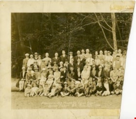
Brackman-Ker Milling Co. Jubilee Picnic at Bowen Island
https://search.heritageburnaby.ca/link/museumdescription2958
- Repository
- Burnaby Village Museum
- Date
- August 11, 1928
- Collection/Fonds
- Burnaby Village Museum Photograph collection
- Description Level
- Item
- Physical Description
- 1 photograph : sepia ; panorama 53 x 20.2 cm
- Scope and Content
- Photograph is a panorama of the "BRACKMAN-KER MILLING CO. JUBILE(sic) PICNIC / BOWEN ISLAND, B.C. AUG.11th, 1928". The photograph presumably shows the employees and families of the Brackman-Ker Milling Co. The adults are mostly posed standing in four rows. There are some children being held in…
- Repository
- Burnaby Village Museum
- Collection/Fonds
- Burnaby Village Museum Photograph collection
- Description Level
- Item
- Physical Description
- 1 photograph : sepia ; panorama 53 x 20.2 cm
- Scope and Content
- Photograph is a panorama of the "BRACKMAN-KER MILLING CO. JUBILE(sic) PICNIC / BOWEN ISLAND, B.C. AUG.11th, 1928". The photograph presumably shows the employees and families of the Brackman-Ker Milling Co. The adults are mostly posed standing in four rows. There are some children being held in the arms of adults, but most of the children in the photograph are seated on the ground along the front of the group. There is also a dog lying down on the ground to the right side of the group. The group is posed in a grassy area, with trees and the roof of a square building visible in the background.
- Subjects
- Celebrations - Jubilee
- Accession Code
- HV971.1.35
- Access Restriction
- No restrictions
- Reproduction Restriction
- No known restrictions
- Date
- August 11, 1928
- Media Type
- Photograph
- Scan Resolution
- 600
- Scan Date
- 2023-03-23
- Photographer
- Stride, Charles Edgar
- Notes
- Title based on contents of photograph
- Title on front of photograph read: "BRACKMAN-KER MILLING CO. JUBILE(sic) PICNIC / BOWEN ISLAND, B.C. AUG.11th, 1928" and "PHOTO BY THE STRIDE STUDIOS / NEW WESTMINSTER, B.C."
Images
![Burnaby May Queen, [between 1926 and 1939] thumbnail](/media/hpo/_Data/_BVM_Images/1974/197400290001.jpg?width=280)
Burnaby May Queen
https://search.heritageburnaby.ca/link/museumdescription917
- Repository
- Burnaby Village Museum
- Date
- [between 1926 and 1939]
- Collection/Fonds
- Burnaby Village Museum Photograph collection
- Description Level
- Item
- Physical Description
- 1 photograph : b&w ; 23 x 18 cm (sight), mounted in folder 87 x 25.5 cm folded to 34 x 25.5 cm
- Scope and Content
- Photograph of a Burnaby May Queen sitting in profile with a bouquet of tulips at her side. She is wearing a diamond necklace and a 'crown of flowers' in her hair.
- Repository
- Burnaby Village Museum
- Collection/Fonds
- Burnaby Village Museum Photograph collection
- Description Level
- Item
- Physical Description
- 1 photograph : b&w ; 23 x 18 cm (sight), mounted in folder 87 x 25.5 cm folded to 34 x 25.5 cm
- Scope and Content
- Photograph of a Burnaby May Queen sitting in profile with a bouquet of tulips at her side. She is wearing a diamond necklace and a 'crown of flowers' in her hair.
- Subjects
- Events - May Day
- Accession Code
- HV974.29.1
- Access Restriction
- No restrictions
- Date
- [between 1926 and 1939]
- Media Type
- Photograph
- Scan Resolution
- 600
- Scan Date
- 1/11/2010
- Scale
- 100
- Photographer
- Stride, Charles Edgar
- Notes
- Title based on contents of photograph
- Window mat (at interior of folder) has decorative embossing
- Window mat and folder backing (provided by photographic studio) are glued together
- Photographer's mark on recto of card mount reads: "The Stride Studios, New Westminster, B.C."
Images
![Burnaby May Queen, [between 1926 and 1939] thumbnail](/media/hpo/_Data/_BVM_Images/1974/197400290001.jpg)

Ina Esther Stanley
https://search.heritageburnaby.ca/link/museumdescription20150
- Repository
- Burnaby Village Museum
- Date
- 1924
- Collection/Fonds
- Esther Love Stanley fonds
- Description Level
- Item
- Physical Description
- 1 photograph : b&w ; 13.5 x 10 cm
- Scope and Content
- Photograph proof of protrait of baby Ina Esther (Stanley) Shankie seated in a wicker chair. Photograph was taken in The Brighton Studio in New Westminster.
- Repository
- Burnaby Village Museum
- Collection/Fonds
- Esther Love Stanley fonds
- Description Level
- Item
- Physical Description
- 1 photograph : b&w ; 13.5 x 10 cm
- Scope and Content
- Photograph proof of protrait of baby Ina Esther (Stanley) Shankie seated in a wicker chair. Photograph was taken in The Brighton Studio in New Westminster.
- Subjects
- Persons - Children
- Accession Code
- BV022.32.572
- Access Restriction
- No restrictions
- Reproduction Restriction
- No known restrictions
- Date
- 1924
- Media Type
- Photograph
- Scan Resolution
- 600
- Scan Date
- 2023-09-07
- Photographer
- Stride, Charles Edgar
- Notes
- Title based on contents of photograph
- Photograph is part of Esther Love Stanley photograph album 2 (BV032.22.431)
- Note in white ink on album page reads: "INA ESTHER STANLEY / BORN JANUARY 26, 1924"
- Stamp on front of photograph reads: "PROOF ONLY"
- Stamp on verso of photograph reads: "PROOF ONLY / PORTRAIT BY / THE BRIGHTON STUDIO / NEW WESTMINSTER B.C. / You can buy three extra portraits like this one in / standard mounts for $2.50 / PROOF / Please keep this ...."
Images

![Livestock Parade, [1920] thumbnail](/media/hpo/_Data/_Archives_Images/_Unrestricted/001/053-004.jpg?width=280)
Livestock Parade
https://search.heritageburnaby.ca/link/archivedescription34573
- Repository
- City of Burnaby Archives
- Date
- [1920]
- Collection/Fonds
- Burnaby Historical Society fonds
- Description Level
- Item
- Physical Description
- 1 photograph : b&w ; 27.6 x 35.3 cm
- Scope and Content
- Photograph of a livestock parade at the Provincial Exhibition. People are standing with animals, including goats, horses and cattle, in a field in front of a building.
- Repository
- City of Burnaby Archives
- Date
- [1920]
- Collection/Fonds
- Burnaby Historical Society fonds
- Subseries
- Photographs subseries
- Physical Description
- 1 photograph : b&w ; 27.6 x 35.3 cm
- Description Level
- Item
- Record No.
- 053-004
- Access Restriction
- No restrictions
- Reproduction Restriction
- No known restrictions
- Accession Number
- BHS2007-04
- Scope and Content
- Photograph of a livestock parade at the Provincial Exhibition. People are standing with animals, including goats, horses and cattle, in a field in front of a building.
- Subjects
- Animals - Cows
- Exhibitions - Agricultural
- Animals - Goats
- Animals - Horses
- Events - Parades
- Media Type
- Photograph
- Notes
- Title based on contents of photograph
- Caption underneath the photograph reads, "Live stock [sic] parade at the Provincial Exhibition, 1920. New Westminster, B.C."
Images
![Livestock Parade, [1920] thumbnail](/media/hpo/_Data/_Archives_Images/_Unrestricted/001/053-004.jpg)
![Map of proposed provincial exhibition site at Burnaby Lake, [between 1929 and 1931] thumbnail](/media/hpo/_Data/_BVM_Cartographic_Material/2017/2017_0002_0009_005.jpg?width=280)
Map of proposed provincial exhibition site at Burnaby Lake
https://search.heritageburnaby.ca/link/museumdescription8703
- Repository
- Burnaby Village Museum
- Date
- [between 1929 and 1931]
- Collection/Fonds
- Burnaby Village Museum Map collection
- Description Level
- Item
- Physical Description
- 1 map : photostat print ; 3 parts 45 x 33.7 cm totalling 45 x 101 cm
- Scope and Content
- Item consists of a tri-part folding map of a proposed Provincial Exhibition site located along the southern and western shore of Burnaby Lake. Exhibtion site on map identifies proposed locations for a golf course, pier, hydroplane landing ramp, sports ground, one-mile horse racing track and various…
- Repository
- Burnaby Village Museum
- Collection/Fonds
- Burnaby Village Museum Map collection
- Description Level
- Item
- Physical Description
- 1 map : photostat print ; 3 parts 45 x 33.7 cm totalling 45 x 101 cm
- Material Details
- Scale [1:1800]
- Scope and Content
- Item consists of a tri-part folding map of a proposed Provincial Exhibition site located along the southern and western shore of Burnaby Lake. Exhibtion site on map identifies proposed locations for a golf course, pier, hydroplane landing ramp, sports ground, one-mile horse racing track and various buildings for mechanical, agricultural and botanical displays.
- Subjects
- Exhibitions
- Accession Code
- BV017.2.9
- Access Restriction
- No restrictions
- Reproduction Restriction
- No known restrictions
- Date
- [between 1929 and 1931]
- Media Type
- Cartographic Material
- Historic Neighbourhood
- Burnaby Lake (Historic Neighbourhood)
- Planning Study Area
- Burnaby Lake Area
- Scan Resolution
- 400
- Scan Date
- 2021-11-18
- Notes
- Title based on contents of map
- Scale on map reads: "150 feet to 1 inch"
- Overall measurements when fully opened: L: 98.0 cm x H: 45.3 cm ; Individual map parts: L: 32.7 cm x H: 45.0 cm
- Commercially printed label on front of portfolio card reads "PLOWRIGHT PRINTING COMPANY / TELEPHONE N.W. 1942 / 39 McKENZIE STREET NEW WESTMINSTER, B.C. / TO: [illegible writing in pencil]" in blue ink. Red typewritten text reads: "PHOTOSTAT OF BURNABY LAKE".
Images
![Map of proposed provincial exhibition site at Burnaby Lake, [between 1929 and 1931] thumbnail](/media/hpo/_Data/_BVM_Cartographic_Material/2017/2017_0002_0009_005.jpg)


![Mary Francis Stanley, [1924] thumbnail](/media/hpo/_Data/_BVM_Images/2022/2022_0032_0571_001.jpg?width=280)
Mary Francis Stanley
https://search.heritageburnaby.ca/link/museumdescription20149
- Repository
- Burnaby Village Museum
- Date
- [1924]
- Collection/Fonds
- Esther Love Stanley fonds
- Description Level
- Item
- Physical Description
- 1 photograph : b&w ; 14 x 10 cm
- Scope and Content
- Photograph proof of portrait of Mary Francis (Stanley) Pearson (toddler age) taken in The Brighton Studio in New Westminster.
- Repository
- Burnaby Village Museum
- Collection/Fonds
- Esther Love Stanley fonds
- Description Level
- Item
- Physical Description
- 1 photograph : b&w ; 14 x 10 cm
- Scope and Content
- Photograph proof of portrait of Mary Francis (Stanley) Pearson (toddler age) taken in The Brighton Studio in New Westminster.
- Subjects
- Persons - Children
- Accession Code
- BV022.32.571
- Access Restriction
- No restrictions
- Reproduction Restriction
- No known restrictions
- Date
- [1924]
- Media Type
- Photograph
- Scan Resolution
- 600
- Scan Date
- 2023-09-06
- Photographer
- Stride, Charles Edgar
- Notes
- Title based on contents of photograph
- Photograph is part of Esther Love Stanley photograph album 2 (BV032.22.431)
- Note in white ink on album page reads: "MARY STANLEY / BORN 1922"
- Stamp on front of photograph reads: "PROOF ONLY"
- Stamp on verso of photograph reads: "PROOF ONLY / PORTRAIT BY / THE BRIGHTON STUDIO / NEW WESTMINSTER B.C. / You can buy three extra portraits like this one in / standard mounts for $2.50 / PROOF / Please keep this ...."
Images
![Mary Francis Stanley, [1924] thumbnail](/media/hpo/_Data/_BVM_Images/2022/2022_0032_0571_001.jpg)
![May Queen and her suite, [between 1926 and 1939] thumbnail](/media/hpo/_Data/_BVM_Images/1974/197400290003.jpg?width=280)
May Queen and her suite
https://search.heritageburnaby.ca/link/museumdescription919
- Repository
- Burnaby Village Museum
- Date
- [between 1926 and 1939]
- Collection/Fonds
- Burnaby Village Museum Photograph collection
- Description Level
- Item
- Physical Description
- 1 photograph : sepia ; 17.5 x 23 cm (sight), mounted in folder 43 x 31 folded to 27 x 31 cm
- Scope and Content
- Photograph of Burnaby's May Queen and her suite seated with flowers at a photographic studio.
- Repository
- Burnaby Village Museum
- Collection/Fonds
- Burnaby Village Museum Photograph collection
- Description Level
- Item
- Physical Description
- 1 photograph : sepia ; 17.5 x 23 cm (sight), mounted in folder 43 x 31 folded to 27 x 31 cm
- Scope and Content
- Photograph of Burnaby's May Queen and her suite seated with flowers at a photographic studio.
- Subjects
- Events - May Day
- Accession Code
- HV974.29.3
- Access Restriction
- No restrictions
- Date
- [between 1926 and 1939]
- Media Type
- Photograph
- Scan Resolution
- 600
- Scan Date
- 1/8/2010
- Scale
- 100
- Photographer
- Stride, Charles Edgar
- Notes
- Title based on contents of photograph
- Window mat (at interior of folder) has decorative embossing
- Window mat and folder backing (provided by photographic studio) are glued together
- Photographer's mark on recto of card mount reads: "The Stride Studios, New Westminster, B.C."
Images
![May Queen and her suite, [between 1926 and 1939] thumbnail](/media/hpo/_Data/_BVM_Images/1974/197400290003.jpg)
![May Queen and her suite, [between 1926 and 1929] thumbnail](/media/hpo/_Data/_BVM_Images/1985/1985_5406_0001_001.jpg?width=280)
May Queen and her suite
https://search.heritageburnaby.ca/link/museumdescription3187
- Repository
- Burnaby Village Museum
- Date
- [between 1926 and 1929]
- Collection/Fonds
- Burnaby Village Museum Photograph collection
- Description Level
- Item
- Physical Description
- 1 photograph : b&w ; 17.5 x 23.5 cm in matt 23 x 27.5 cm on top of matt 35.5 40.5 cm in frame 45.5 x 50 cm
- Scope and Content
- Photograph portrait of May Queen and her suite. Four young women are dressed in white May Day costumes with white dresses and capes with fur collars. Two of the girls are seated on either side of two girls that are standing. Three baskets of flowers are displayed on the floor in front.
- Repository
- Burnaby Village Museum
- Collection/Fonds
- Burnaby Village Museum Photograph collection
- Description Level
- Item
- Physical Description
- 1 photograph : b&w ; 17.5 x 23.5 cm in matt 23 x 27.5 cm on top of matt 35.5 40.5 cm in frame 45.5 x 50 cm
- Material Details
- Photograph matted within oak frame with glass
- backing ripped diagonally from upper left corner to lower right; inner cardboard card showing
- gold border; photo mounted on black card, grey mat
- Scope and Content
- Photograph portrait of May Queen and her suite. Four young women are dressed in white May Day costumes with white dresses and capes with fur collars. Two of the girls are seated on either side of two girls that are standing. Three baskets of flowers are displayed on the floor in front.
- Subjects
- Events - May Day
- Accession Code
- BV985.5406.1
- Access Restriction
- No restrictions
- Reproduction Restriction
- No known restrictions
- Date
- [between 1926 and 1929]
- Media Type
- Photograph
- Notes
- Title based on contents of photograph
- Handwritten signature [illegible] in black ink on bottom right corner of matt
- Stamp on verso of frame reads: "Framed by The Stride Studios / 657 Columbia St., New Westminster, B.C."
Images
![May Queen and her suite, [between 1926 and 1929] thumbnail](/media/hpo/_Data/_BVM_Images/1985/1985_5406_0001_001.jpg)

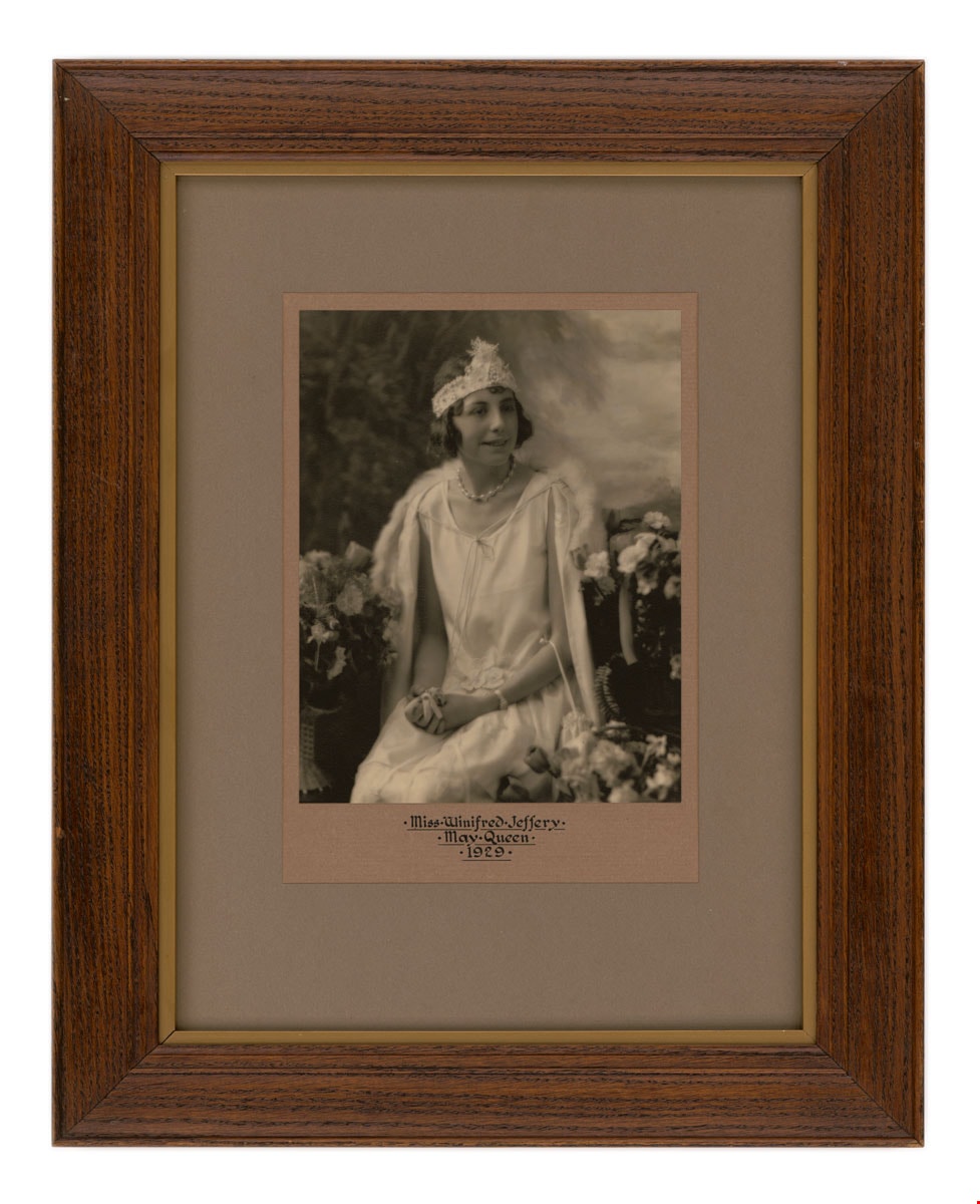
May Queen Miss Winifred Jeffery
https://search.heritageburnaby.ca/link/museumdescription3185
- Repository
- Burnaby Village Museum
- Date
- May 1929
- Collection/Fonds
- Burnaby Village Museum Photograph collection
- Description Level
- Item
- Physical Description
- 1 photograph : b&w ; 24.5 x 19.5 cm in matt 43 x 33 cm in frame 43.5 x 54 cm
- Scope and Content
- Photograph portrait of Burnaby May Queen, Winnifred Jeffery. Miss Jeffery is dressed in a May Queen costume with a basket of flowers on each side.
- Repository
- Burnaby Village Museum
- Collection/Fonds
- Burnaby Village Museum Photograph collection
- Description Level
- Item
- Physical Description
- 1 photograph : b&w ; 24.5 x 19.5 cm in matt 43 x 33 cm in frame 43.5 x 54 cm
- Material Details
- Photograph mounted on ecru cardboard, then onto taupe cardboard; gold border between oak frame and glass
- small tears and marks on paper backing; wire for hanging;
- Scope and Content
- Photograph portrait of Burnaby May Queen, Winnifred Jeffery. Miss Jeffery is dressed in a May Queen costume with a basket of flowers on each side.
- Subjects
- Events - May Day
- Names
- Jeffery, Winnifred
- Accession Code
- BV985.5402.1
- Access Restriction
- No restrictions
- Reproduction Restriction
- No known restrictions
- Date
- May 1929
- Media Type
- Photograph
- Photographer
- Stride, Charles Edgar
- Notes
- Title based on contents of photograph
- Title on matt in black ink below photograph reads: ". Miss:Winnifred.Jeffery . / . May Queen. / .1929."
- Printing on navy blue photographer's label on verso of frame reads: "Framed By / The Stride Studios / Chas E. Stride / 657 Columbia St. / New Westminster, B.C. / We Carry an Exclusive Line of Framed Pictures"
Images
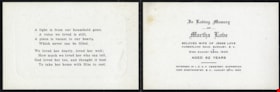
Memorial cards for Martha Love
https://search.heritageburnaby.ca/link/museumdescription10093
- Repository
- Burnaby Village Museum
- Date
- 1920
- Collection/Fonds
- Love family fonds
- Description Level
- File
- Physical Description
- 1 folder of textual records
- Scope and Content
- File consists of a three memorial cards for Martha Love which read: "In Loving Memory / OF / Martha Love / BELOVED WIFE OF JESSE LOVE / CUMBERLAND ROAD, BURNABY, B.C. / Died August 24RD. 1920 / AGED 62 YEARS / INTERRED IN I.O.O.F. CEMETERY, SAPPERTON / NEW WESTMINSTER, B.C., AUGUST 26TH, 1920". A s…
- Repository
- Burnaby Village Museum
- Collection/Fonds
- Love family fonds
- Description Level
- File
- Physical Description
- 1 folder of textual records
- Scope and Content
- File consists of a three memorial cards for Martha Love which read: "In Loving Memory / OF / Martha Love / BELOVED WIFE OF JESSE LOVE / CUMBERLAND ROAD, BURNABY, B.C. / Died August 24RD. 1920 / AGED 62 YEARS / INTERRED IN I.O.O.F. CEMETERY, SAPPERTON / NEW WESTMINSTER, B.C., AUGUST 26TH, 1920". A short, religious poem is printed on the inside face of the card. "IN LOVING / MEMORY" with an image of a rose is printed on the front face of the card.
- History
- See extensive history of Love Family and Love farmhouse located at Burnaby Village Museum.
- Accession Code
- BV012.31.25
- Access Restriction
- No restrictions
- Reproduction Restriction
- No known restrictions
- Date
- 1920
- Media Type
- Textual Record
- Scan Resolution
- 600
- Scan Date
- 7-May-20
- Scale
- 100
- Notes
- Title based on content of file
Images
