More like 'Land surveyor on a road'
Narrow Results By
Decade
- 2020s 62
- 2010s 108
- 2000s 490
- 1990s 506
- 1980s 279
- 1970s 492
- 1960s 332
- 1950s 299
- 1940s 527
- 1930s 438
- 1920s
- 1910s 456
- 1900s 220
- 1890s 40
- 1880s 33
- 1870s
- 1860s 5
- 1850s 2
- 1840s 1
- 1830s 1
- 1820s 1
- 1810s 2
- 1800s 2
- 1790s 2
- 1780s 2
- 1770s 2
- 1760s 2
- 1750s 2
- 1740s 2
- 1730s 2
- 1720s 2
- 1710s 2
- 1700s 2
- 1690s 2
- 1680s 2
- 1670s 2
- 1660s 2
- 1650s 2
- 1640s 2
- 1630s 2
- 1620s 2
- 1610s 2
- 1600s 2
- 1590s 1
- 1580s 1
- 1570s 1
- 1560s 1
- 1550s 1
- 1540s 1
- 1530s 1
- 1520s 1
- 1510s 1
- 1500s 1
- 1490s 1
- 1480s 1
Subject
- Advertising Medium - Signs and Signboards 3
- Agricultural Tools and Equipment 2
- Agricultural Tools and Equipment - Gardening Equipment 1
- Agricultural Tools and Equipment - Plows 1
- Agriculture 1
- Agriculture - Crops 3
- Agriculture - Farms 4
- Agriculture - Fruit and Berries 1
- Animals - Cats 3
- Animals - Deer 1
- Animals - Dogs 10
- Animals - Fowl 1
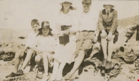
Children on the beach
https://search.heritageburnaby.ca/link/archivedescription39270
- Repository
- City of Burnaby Archives
- Date
- 1920
- Collection/Fonds
- Peers Family and Hill Family fonds
- Description Level
- Item
- Physical Description
- 1 photograph : b&w ; 6 x 10.2 cm on page 24.5 x 32.5 cm (pasted in album)
- Scope and Content
- Photograph of five children sitting on the beach. The girl in the middle is holding a box camera on her lap.
- Repository
- City of Burnaby Archives
- Date
- 1920
- Collection/Fonds
- Peers Family and Hill Family fonds
- Physical Description
- 1 photograph : b&w ; 6 x 10.2 cm on page 24.5 x 32.5 cm (pasted in album)
- Description Level
- Item
- Record No.
- 477-589
- Access Restriction
- No restrictions
- Reproduction Restriction
- No known restrictions
- Accession Number
- 2007-12
- Scope and Content
- Photograph of five children sitting on the beach. The girl in the middle is holding a box camera on her lap.
- Media Type
- Photograph
- Notes
- Title based on contents of photograph
Images

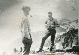
Dave Gray and Bob Wood
https://search.heritageburnaby.ca/link/archivedescription35693
- Repository
- City of Burnaby Archives
- Date
- May 1927 (date of original), copied 1986
- Collection/Fonds
- Burnaby Historical Society fonds
- Description Level
- Item
- Physical Description
- 1 photograph : b&w ; 12.7 x 17.8 cm print
- Scope and Content
- Photograph of Dave Gray and Bob Wood on a hike to the Lions peaks in West Vancouver. Dave Gray has his pipe clenched in his teeth, as Bob Wood points a box camera at him. The third member of hiking party, Art Hilton (not pictured), took this photograph. Dave Gray, a famous baseball player and late…
- Repository
- City of Burnaby Archives
- Date
- May 1927 (date of original), copied 1986
- Collection/Fonds
- Burnaby Historical Society fonds
- Subseries
- Pioneer Tales subseries
- Physical Description
- 1 photograph : b&w ; 12.7 x 17.8 cm print
- Description Level
- Item
- Record No.
- 204-551
- Access Restriction
- No restrictions
- Reproduction Restriction
- Reproduce for fair dealing purposes only
- Accession Number
- BHS1988-03
- Scope and Content
- Photograph of Dave Gray and Bob Wood on a hike to the Lions peaks in West Vancouver. Dave Gray has his pipe clenched in his teeth, as Bob Wood points a box camera at him. The third member of hiking party, Art Hilton (not pictured), took this photograph. Dave Gray, a famous baseball player and later teacher, was an all-round athlete who once taught Bob Wood. David Gray Park and swimming pool in South Burnaby were named after him.
- Media Type
- Photograph
- Photographer
- Hilton, Art
- Notes
- Title based on contents of photograph
Images

![Arthur Francis Peers, [1927] thumbnail](/media/hpo/_Data/_Archives_Images/_Unrestricted/001/020-171.jpg?width=280)
Arthur Francis Peers
https://search.heritageburnaby.ca/link/archivedescription34464
- Repository
- City of Burnaby Archives
- Date
- [1927]
- Collection/Fonds
- Burnaby Historical Society fonds
- Description Level
- Item
- Physical Description
- 1 photograph : sepia ; 6 x 11.8 cm on page 17.5 x 26.2 cm
- Scope and Content
- Photograph of Arthur Francis Peers standing near railway tracks at an unknown location. Snow can be seen covering the ground and Arthur is pictured wearing winter jacket, boots, hat and mittens. In his right hand he is holding a box camera and he is smoking a pipe. Throughout the late 1920s, Arthu…
- Repository
- City of Burnaby Archives
- Date
- [1927]
- Collection/Fonds
- Burnaby Historical Society fonds
- Subseries
- Peers family subseries
- Physical Description
- 1 photograph : sepia ; 6 x 11.8 cm on page 17.5 x 26.2 cm
- Description Level
- Item
- Record No.
- 020-171
- Access Restriction
- No restrictions
- Reproduction Restriction
- No known restrictions
- Accession Number
- BHS2007-04
- Scope and Content
- Photograph of Arthur Francis Peers standing near railway tracks at an unknown location. Snow can be seen covering the ground and Arthur is pictured wearing winter jacket, boots, hat and mittens. In his right hand he is holding a box camera and he is smoking a pipe. Throughout the late 1920s, Arthur Peers travelled throughout the Fraser Valley, British Columbia during the construction of the Trans-Provincial Highway and documented a lot of the work through his photographs. A caption to this picture reads: "Breaking camp."
- Media Type
- Photograph
- Notes
- Title based on contents of photograph
Images
![Arthur Francis Peers, [1927] thumbnail](/media/hpo/_Data/_Archives_Images/_Unrestricted/001/020-171.jpg)

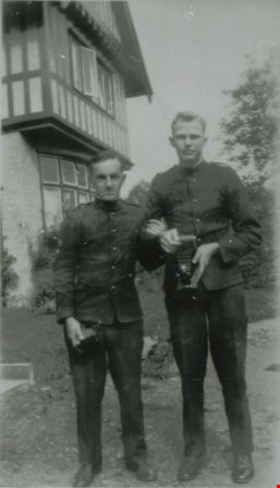
Chip and Roy at Hart House
https://search.heritageburnaby.ca/link/archivedescription38004
- Repository
- City of Burnaby Archives
- Date
- 1929 (date of original), copied 1991
- Collection/Fonds
- Burnaby Historical Society fonds
- Description Level
- Item
- Physical Description
- 1 photograph : b&w ; 4.6 x 2.6 cm print on contact sheet 20.5 x 26.4 cm
- Scope and Content
- Photograph of Chip and Roy, two Australian soldiers or sailors, at Hart House. They are in uniform, and one of them is holding a camera.
- Repository
- City of Burnaby Archives
- Date
- 1929 (date of original), copied 1991
- Collection/Fonds
- Burnaby Historical Society fonds
- Subseries
- Burnaby Image Bank subseries
- Physical Description
- 1 photograph : b&w ; 4.6 x 2.6 cm print on contact sheet 20.5 x 26.4 cm
- Description Level
- Item
- Record No.
- 370-591
- Access Restriction
- No restrictions
- Reproduction Restriction
- No known restrictions
- Accession Number
- BHS1999-03
- Scope and Content
- Photograph of Chip and Roy, two Australian soldiers or sailors, at Hart House. They are in uniform, and one of them is holding a camera.
- Subjects
- Photographic Tools and Equipment - Cameras
- Occupations - Military Personnel
- Clothing - Military Uniforms
- Media Type
- Photograph
- Notes
- Title based on contents of photograph
- 1 b&w copy negative accompanying
- Geographic Access
- Deer Lake Avenue
- Street Address
- 6664 Deer Lake Avenue
- Historic Neighbourhood
- Burnaby Lake (Historic Neighbourhood)
- Planning Study Area
- Morley-Buckingham Area
Images
Surveyor field book 32
https://search.heritageburnaby.ca/link/museumdescription19633
- Repository
- Burnaby Village Museum
- Date
- 1913-1929, predominant 1913
- Collection/Fonds
- Burnaby Village Museum Map collection
- Description Level
- Item
- Physical Description
- 1 notebook
- Scope and Content
- Item consists of a field notebook with surveyor's field notes created by B.C. Land Surveyor, Walter Wilkie. Field notes include pertinent information, calculations, sketches and observations including geographic areas in Burnaby (D.L.86 and D.L. 136); Surrey (Twp 1, Twp 7); Maple Ridge (Twp 12); La…
- Repository
- Burnaby Village Museum
- Collection/Fonds
- Burnaby Village Museum Map collection
- Description Level
- Item
- Physical Description
- 1 notebook
- Material Details
- Yellow leather hardcover book with inscription on cover "FIELD BOOK";Technical Manufacturing & Supply Co., Vancouver, B.C.
- Annotation in black ink on front cover reads: "32"
- Includes reference tables at front and back of notebook for surveying computations.
- Scope and Content
- Item consists of a field notebook with surveyor's field notes created by B.C. Land Surveyor, Walter Wilkie. Field notes include pertinent information, calculations, sketches and observations including geographic areas in Burnaby (D.L.86 and D.L. 136); Surrey (Twp 1, Twp 7); Maple Ridge (Twp 12); Langley (Twp 10, Twp 11 and Lots 36, 304, 308, 309, 312); Dewdney (D.L. 484 Group 1) and Coquitlam (D.L.366 Group 1). Notebook includes a handwritten index of surveying content, on the last few pages at back of book.
- Creator
- Wilkie, "Walter" Gerald
- Subjects
- Occupations - Land Surveyors
- Accession Code
- HV977.128.1
- Access Restriction
- No restrictions
- Reproduction Restriction
- No known restrictions
- Date
- 1913-1929, predominant 1913
- Media Type
- Textual Record
- Notes
- Title based on contents of item

Road cleared through a forest
https://search.heritageburnaby.ca/link/archivedescription34400
- Repository
- City of Burnaby Archives
- Date
- 1926
- Collection/Fonds
- Burnaby Historical Society fonds
- Description Level
- Item
- Physical Description
- 1 photograph : b&w ; 6.5 x 10 cm on page 17.5 x 26.5 cm
- Scope and Content
- Photograph of a roadway that has been cut through the forest. Tree stumps are lining the road and the ground is covered with snow. A caption adjacent to the photograph reads "Tony's Work." This photograph appears to have been taken by Arthur Peers, who travelled through the Fraser River Valley and…
- Repository
- City of Burnaby Archives
- Date
- 1926
- Collection/Fonds
- Burnaby Historical Society fonds
- Subseries
- Peers family subseries
- Physical Description
- 1 photograph : b&w ; 6.5 x 10 cm on page 17.5 x 26.5 cm
- Description Level
- Item
- Record No.
- 020-107
- Access Restriction
- No restrictions
- Reproduction Restriction
- No known restrictions
- Accession Number
- BHS2007-04
- Scope and Content
- Photograph of a roadway that has been cut through the forest. Tree stumps are lining the road and the ground is covered with snow. A caption adjacent to the photograph reads "Tony's Work." This photograph appears to have been taken by Arthur Peers, who travelled through the Fraser River Valley and worked on the construction of the Trans-Provincial Highway during the later 1920s.
- Media Type
- Photograph
- Photographer
- Peers, Arthur Francis "Mike"
- Notes
- Title based on contents of photograph
Images

![Mr. Manuel with a plough, [192-] (date of original), copied 1991 thumbnail](/media/hpo/_Data/_Archives_Images/_Unrestricted/370/370-100.jpg?width=280)
Mr. Manuel with a plough
https://search.heritageburnaby.ca/link/archivedescription37512
- Repository
- City of Burnaby Archives
- Date
- [192-] (date of original), copied 1991
- Collection/Fonds
- Burnaby Historical Society fonds
- Description Level
- Item
- Physical Description
- 1 photograph : b&w ; 3.1 x 5.3 cm print on contact sheet 20.3 x 25.3 cm
- Scope and Content
- Photograph of Mr. Manuel working a plough pulled by two horses at Cassie Avenue (later the location of Metrotown).
- Repository
- City of Burnaby Archives
- Date
- [192-] (date of original), copied 1991
- Collection/Fonds
- Burnaby Historical Society fonds
- Subseries
- Burnaby Image Bank subseries
- Physical Description
- 1 photograph : b&w ; 3.1 x 5.3 cm print on contact sheet 20.3 x 25.3 cm
- Description Level
- Item
- Record No.
- 370-100
- Access Restriction
- No restrictions
- Reproduction Restriction
- No known restrictions
- Accession Number
- BHS1999-03
- Scope and Content
- Photograph of Mr. Manuel working a plough pulled by two horses at Cassie Avenue (later the location of Metrotown).
- Subjects
- Geographic Features - Fields
- Transportation - Horses
- Agricultural Tools and Equipment - Plows
- Occupations - Farmers
- Media Type
- Photograph
- Notes
- Title based on contents of photograph
- 1 b&w copy negative accompanying
- Geographic Access
- Cassie Avenue
- Historic Neighbourhood
- Central Park (Historic Neighbourhood)
- Planning Study Area
- Maywood Area
Images
![Mr. Manuel with a plough, [192-] (date of original), copied 1991 thumbnail](/media/hpo/_Data/_Archives_Images/_Unrestricted/370/370-100.jpg)

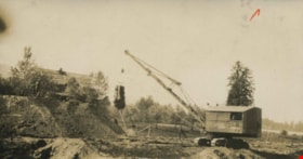
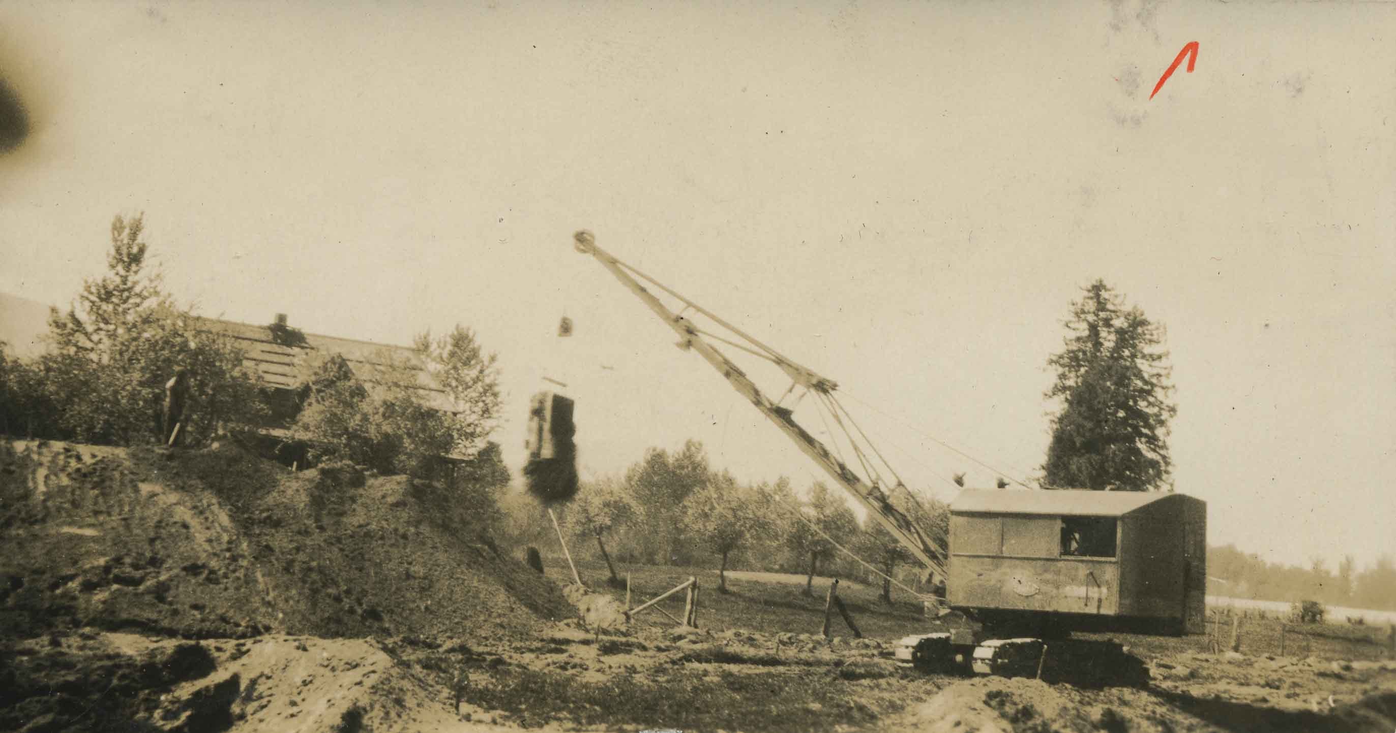
Digging In
https://search.heritageburnaby.ca/link/archivedescription34387
- Repository
- City of Burnaby Archives
- Date
- 1926
- Collection/Fonds
- Burnaby Historical Society fonds
- Description Level
- Item
- Physical Description
- 1 photograph : b&w ; 7.5 x 7 cm on page 17.5 x 26.5 cm
- Scope and Content
- Photograph of a steam shovel digging into a hill. A horse team pulling a dump wagon stand next to it. The location is unknown. This photograph appears to have been taken by Arthur Peers, who travelled through the Fraser River Valley and worked on the construction of the Trans-Provincial Highway dur…
- Repository
- City of Burnaby Archives
- Date
- 1926
- Collection/Fonds
- Burnaby Historical Society fonds
- Subseries
- Peers family subseries
- Physical Description
- 1 photograph : b&w ; 7.5 x 7 cm on page 17.5 x 26.5 cm
- Description Level
- Item
- Record No.
- 020-094
- Access Restriction
- No restrictions
- Reproduction Restriction
- No known restrictions
- Accession Number
- BHS2007-04
- Scope and Content
- Photograph of a steam shovel digging into a hill. A horse team pulling a dump wagon stand next to it. The location is unknown. This photograph appears to have been taken by Arthur Peers, who travelled through the Fraser River Valley and worked on the construction of the Trans-Provincial Highway during the later 1920s.
- Subjects
- Land Clearing
- Occupations - Labourers
- Transportation - Horses
- Transportation - Wagons
- Construction Tools and Equipment
- Media Type
- Photograph
- Photographer
- Peers, Arthur Francis "Mike"
- Notes
- Title based on caption accompanying photograph
Images


Dyke construction on Nicomen Island
https://search.heritageburnaby.ca/link/archivedescription34332
- Repository
- City of Burnaby Archives
- Date
- 1927
- Collection/Fonds
- Burnaby Historical Society fonds
- Description Level
- Item
- Physical Description
- 1 photograph : sepia ; 5.7 x 13.2 cm on page 17.5 x 22.7 cm
- Scope and Content
- Photograph of machinery and equipment working on the construction of dykes on Nicomen Island.
- Repository
- City of Burnaby Archives
- Date
- 1927
- Collection/Fonds
- Burnaby Historical Society fonds
- Subseries
- Peers family subseries
- Physical Description
- 1 photograph : sepia ; 5.7 x 13.2 cm on page 17.5 x 22.7 cm
- Description Level
- Item
- Record No.
- 020-039
- Access Restriction
- No restrictions
- Reproduction Restriction
- No known restrictions
- Accession Number
- BHS2007-04
- Scope and Content
- Photograph of machinery and equipment working on the construction of dykes on Nicomen Island.
- Media Type
- Photograph
- Notes
- Title based on caption accompanying photograph
Images


Dykes on Nicomen Island
https://search.heritageburnaby.ca/link/archivedescription34333
- Repository
- City of Burnaby Archives
- Date
- 1927
- Collection/Fonds
- Burnaby Historical Society fonds
- Description Level
- Item
- Physical Description
- 1 photograph : sepia ; 6.5 x 13.7 cm on page 17.5 x 22.7 cm
- Scope and Content
- Photograph of a barn (in the background), along the river bank near the dykes under construction on Nicomen Island.
- Repository
- City of Burnaby Archives
- Date
- 1927
- Collection/Fonds
- Burnaby Historical Society fonds
- Subseries
- Peers family subseries
- Physical Description
- 1 photograph : sepia ; 6.5 x 13.7 cm on page 17.5 x 22.7 cm
- Description Level
- Item
- Record No.
- 020-040
- Access Restriction
- No restrictions
- Reproduction Restriction
- No known restrictions
- Accession Number
- BHS2007-04
- Scope and Content
- Photograph of a barn (in the background), along the river bank near the dykes under construction on Nicomen Island.
- Media Type
- Photograph
- Notes
- Title based on caption accompanying photograph
Images


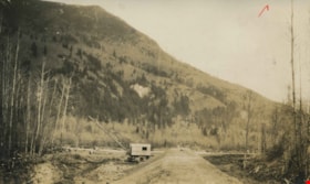
Road round 1st tunnel
https://search.heritageburnaby.ca/link/archivedescription34407
- Repository
- City of Burnaby Archives
- Date
- 1925
- Collection/Fonds
- Burnaby Historical Society fonds
- Description Level
- Item
- Physical Description
- 1 photograph : b&w ; 7 x 12.2 cm on page 17.5 x 26.5 cm
- Scope and Content
- Photographs taken in Yale, looking toward a tunnel cut through a rock face at the side of a mountain. A caption written under the photograph reads "road round [sic] 1st tunnel." This photograph appears to have been taken by Arthur Peers, who travelled through the Fraser River Valley and worked on …
- Repository
- City of Burnaby Archives
- Date
- 1925
- Collection/Fonds
- Burnaby Historical Society fonds
- Subseries
- Peers family subseries
- Physical Description
- 1 photograph : b&w ; 7 x 12.2 cm on page 17.5 x 26.5 cm
- Description Level
- Item
- Record No.
- 020-114
- Access Restriction
- No restrictions
- Reproduction Restriction
- No known restrictions
- Accession Number
- BHS2007-04
- Scope and Content
- Photographs taken in Yale, looking toward a tunnel cut through a rock face at the side of a mountain. A caption written under the photograph reads "road round [sic] 1st tunnel." This photograph appears to have been taken by Arthur Peers, who travelled through the Fraser River Valley and worked on the construction of the Trans-Provincial Highway during the later 1920s.
- Media Type
- Photograph
- Photographer
- Peers, Arthur Francis "Mike"
- Notes
- Title based on caption accompanying photograph
Images

![Roads and sidewalks, [192-] (date of original), copied 1986 thumbnail](/media/hpo/_Data/_Archives_Images/_Unrestricted/204/204-037.jpg?width=280)
Roads and sidewalks
https://search.heritageburnaby.ca/link/archivedescription35180
- Repository
- City of Burnaby Archives
- Date
- [192-] (date of original), copied 1986
- Collection/Fonds
- Burnaby Historical Society fonds
- Description Level
- Item
- Physical Description
- 1 photograph : b&w ; 12.7 x 17.8 cm print
- Scope and Content
- Photograph of dirt roads and sidewalks in Burnaby in the 1920s. George Pearson supervised cement sidewalk building throughout Burnaby during the Great Depression. St. Helen's Roman Catholic Church may be in the background.
- Repository
- City of Burnaby Archives
- Date
- [192-] (date of original), copied 1986
- Collection/Fonds
- Burnaby Historical Society fonds
- Subseries
- Pioneer Tales subseries
- Physical Description
- 1 photograph : b&w ; 12.7 x 17.8 cm print
- Description Level
- Item
- Record No.
- 204-037
- Access Restriction
- No restrictions
- Reproduction Restriction
- No known restrictions
- Accession Number
- BHS1988-03
- Scope and Content
- Photograph of dirt roads and sidewalks in Burnaby in the 1920s. George Pearson supervised cement sidewalk building throughout Burnaby during the Great Depression. St. Helen's Roman Catholic Church may be in the background.
- Subjects
- Geographic Features - Sidewalks
- Geographic Features - Roads
- Buildings - Residential - Houses
- Media Type
- Photograph
- Notes
- Title based on contents of photograph
Images
![Roads and sidewalks, [192-] (date of original), copied 1986 thumbnail](/media/hpo/_Data/_Archives_Images/_Unrestricted/204/204-037.jpg)

Dyke construction on Nicomen Island
https://search.heritageburnaby.ca/link/archivedescription34331
- Repository
- City of Burnaby Archives
- Date
- 1927
- Collection/Fonds
- Burnaby Historical Society fonds
- Description Level
- Item
- Physical Description
- 1 photograph : sepia ; 7 x 13.5 cm on page 17.5 x 22.7 cm
- Scope and Content
- Photograph of a home, with car in the foreground next to equipment being used in the construction of dykes on Nicomen Island.
- Repository
- City of Burnaby Archives
- Date
- 1927
- Collection/Fonds
- Burnaby Historical Society fonds
- Subseries
- Peers family subseries
- Physical Description
- 1 photograph : sepia ; 7 x 13.5 cm on page 17.5 x 22.7 cm
- Description Level
- Item
- Record No.
- 020-038
- Access Restriction
- No restrictions
- Reproduction Restriction
- No known restrictions
- Accession Number
- BHS2007-04
- Scope and Content
- Photograph of a home, with car in the foreground next to equipment being used in the construction of dykes on Nicomen Island.
- Subjects
- Construction Tools and Equipment
- Geographic Features - Dykes
- Buildings - Residential - Houses
- Media Type
- Photograph
- Notes
- Title based on caption accompanying photograph
Images

Nicomen Dyke Construction
https://search.heritageburnaby.ca/link/archivedescription34339
- Repository
- City of Burnaby Archives
- Date
- 1927
- Collection/Fonds
- Burnaby Historical Society fonds
- Description Level
- Item
- Physical Description
- 1 photograph : b&w ; 6.3 x 11.6 cm on page 17.4 x 23.9 cm
- Scope and Content
- Photograph of equipment being used to construct dykes on Nicomen Island.
- Repository
- City of Burnaby Archives
- Date
- 1927
- Collection/Fonds
- Burnaby Historical Society fonds
- Subseries
- Peers family subseries
- Physical Description
- 1 photograph : b&w ; 6.3 x 11.6 cm on page 17.4 x 23.9 cm
- Description Level
- Item
- Record No.
- 020-046
- Access Restriction
- No restrictions
- Reproduction Restriction
- No known restrictions
- Accession Number
- BHS2007-04
- Scope and Content
- Photograph of equipment being used to construct dykes on Nicomen Island.
- Media Type
- Photograph
- Notes
- Title based on caption accompanying photograph
Images
Nicomen Dykes
https://search.heritageburnaby.ca/link/archivedescription34340
- Repository
- City of Burnaby Archives
- Date
- 1927
- Collection/Fonds
- Burnaby Historical Society fonds
- Description Level
- Item
- Physical Description
- 1 photograph : b&w ; 7.7 x 12.9 cm on page 17.4 x 23.9 cm
- Scope and Content
- Photograph of equipment being used to construct dykes on Nicomen Island.
- Repository
- City of Burnaby Archives
- Date
- 1927
- Collection/Fonds
- Burnaby Historical Society fonds
- Subseries
- Peers family subseries
- Physical Description
- 1 photograph : b&w ; 7.7 x 12.9 cm on page 17.4 x 23.9 cm
- Description Level
- Item
- Record No.
- 020-047
- Access Restriction
- No restrictions
- Reproduction Restriction
- No known restrictions
- Accession Number
- BHS2007-04
- Scope and Content
- Photograph of equipment being used to construct dykes on Nicomen Island.
- Media Type
- Photograph
- Notes
- Title based on caption accompanying photograph
Images

![Stave Lake Dam and powerhouse, [c. 1915] thumbnail](/media/hpo/_Data/_BVM_Images/2022/2022_0032_0018_001.jpg?width=280)
Stave Lake Dam and powerhouse
https://search.heritageburnaby.ca/link/museumdescription19301
- Repository
- Burnaby Village Museum
- Date
- [c. 1915]
- Collection/Fonds
- Esther Love Stanley fonds
- Description Level
- Item
- Physical Description
- 1 photograph : b&w ; 10.5 x 8 cm
- Scope and Content
- Photograph of Stave Lake, the Stave Lake Dam and powerhouse in Mission, British Columbia.
- Repository
- Burnaby Village Museum
- Collection/Fonds
- Esther Love Stanley fonds
- Description Level
- Item
- Physical Description
- 1 photograph : b&w ; 10.5 x 8 cm
- Scope and Content
- Photograph of Stave Lake, the Stave Lake Dam and powerhouse in Mission, British Columbia.
- Subjects
- Geographic Features - Lakes and Ponds
- Energy Production Tools and Equipment
- Structures - Dams
- Accession Code
- BV022.32.18
- Access Restriction
- No restrictions
- Reproduction Restriction
- No known restrictions
- Date
- [c. 1915]
- Media Type
- Photograph
- Scan Resolution
- 600
- Scan Date
- 2023-04-04
- Notes
- Title based on contents of photograph
- Photograph is part of Esther Love Stanley photograph album 1 (BV022.32.1)
Images
![Stave Lake Dam and powerhouse, [c. 1915] thumbnail](/media/hpo/_Data/_BVM_Images/2022/2022_0032_0018_001.jpg)
![Water flowing from Stave Lake Dam, [c. 1915] thumbnail](/media/hpo/_Data/_BVM_Images/2022/2022_0032_0019_001.jpg?width=280)
Water flowing from Stave Lake Dam
https://search.heritageburnaby.ca/link/museumdescription19302
- Repository
- Burnaby Village Museum
- Date
- [c. 1915]
- Collection/Fonds
- Esther Love Stanley fonds
- Description Level
- Item
- Physical Description
- 1 photograph : b&w ; 10.5 x 8 cm
- Scope and Content
- Photograph of water flowing from Stave Lake Dam into the Stave River in Mission, British Columbia. Shoreline with large rocks in the foreground and barren trees on the hillsides bordering the river.
- Repository
- Burnaby Village Museum
- Collection/Fonds
- Esther Love Stanley fonds
- Description Level
- Item
- Physical Description
- 1 photograph : b&w ; 10.5 x 8 cm
- Scope and Content
- Photograph of water flowing from Stave Lake Dam into the Stave River in Mission, British Columbia. Shoreline with large rocks in the foreground and barren trees on the hillsides bordering the river.
- Accession Code
- BV022.32.19
- Access Restriction
- No restrictions
- Reproduction Restriction
- No known restrictions
- Date
- [c. 1915]
- Media Type
- Photograph
- Scan Resolution
- 600
- Scan Date
- 2023-04-04
- Notes
- Title based on contents of photograph
- Photograph is part of Esther Love Stanley photograph album 1 (BV022.32.1)
Images
![Water flowing from Stave Lake Dam, [c. 1915] thumbnail](/media/hpo/_Data/_BVM_Images/2022/2022_0032_0019_001.jpg)

Kask Camp
https://search.heritageburnaby.ca/link/archivedescription37413
- Repository
- City of Burnaby Archives
- Date
- May 14, 1924 (date of original), copied 1991
- Collection/Fonds
- Burnaby Historical Society fonds
- Description Level
- Item
- Physical Description
- 1 photograph : b&w ; 3.4 x 5.6 cm print on contact sheet 20.2 x 25.4 cm
- Scope and Content
- Photograph of the plot for the first house built at Kask Camp. The electricity lines shown are from Buntzen Power Plant. Barnet Road is seen on the right.
- Repository
- City of Burnaby Archives
- Date
- May 14, 1924 (date of original), copied 1991
- Collection/Fonds
- Burnaby Historical Society fonds
- Subseries
- Burnaby Image Bank subseries
- Physical Description
- 1 photograph : b&w ; 3.4 x 5.6 cm print on contact sheet 20.2 x 25.4 cm
- Description Level
- Item
- Record No.
- 370-001
- Access Restriction
- No restrictions
- Reproduction Restriction
- No known restrictions
- Accession Number
- BHS1999-03
- Scope and Content
- Photograph of the plot for the first house built at Kask Camp. The electricity lines shown are from Buntzen Power Plant. Barnet Road is seen on the right.
- Names
- Kask Camp
- Media Type
- Photograph
- Photographer
- Kask, William Sr.
- Notes
- Title based on contents of photograph
- 1 b&w copy negative accompanying
- Geographic Access
- Barnet Road
- Street Address
- 7501 Barnet Road
- Historic Neighbourhood
- Barnet (Historic Neighbourhood)
- Planning Study Area
- Burnaby Mountain Area
Images


Alfred Bingham's writings - Track 1
https://search.heritageburnaby.ca/link/oralhistory251
- Repository
- City of Burnaby Archives
- Date Range
- 1865-1919
- Length
- 0:10:18
- Summary
- This portion of the recording includes Alfred Bingham's essay entitled Stump Rangers, a listing of early settlers that includes addresses and short descriptions, essays on Confederation Park, land clearing and on Burnaby's first Council meeting.
- Repository
- City of Burnaby Archives
- Summary
- This portion of the recording includes Alfred Bingham's essay entitled Stump Rangers, a listing of early settlers that includes addresses and short descriptions, essays on Confederation Park, land clearing and on Burnaby's first Council meeting.
- Date Range
- 1865-1919
- Photo Info
- Alfred Bingham, April 20, 1947. Item no. 010-066
- Length
- 0:10:18
- Scope and Content
- Recording is of Alfred Bingham's writings, as read by Alfred Bingham. Major themes discussed are: Pioneers, early days in Burnaby and the Co-op Movement. To view "Narrow By" terms for each track expand this description and see "Notes".
- Biographical Notes
- Alfred "Alf" Bingham was born in England in 1892 and moved to Canada in 1912. His first job in Canada was laying track for the Grand Trunk Pacific Railway (GTPR) from Edmonton to McBride in 1912. His second was in Vancouver at the Rat Portage Mill on False Creek, working on the Resaw machine. He quit after one week due to poor working conditions. After taking part in the 1919 Winnipeg General Strike as a delegate of the Retail and Mailorder Union (A.F.L.) on the Winnipeg Trades and Labour Council, Alfred moved to Burnaby where he and fellow Burnaby residents Aungus McLean and Percy Little worked ten hour days to build a Shingle Mill on the edge of Burnaby Lake for Simpson & Giberson. George Green, carpenter and millwright (author of “The History of Burnaby”) also helped in the construction of the mill. Alfred built his own home from lumber cut from the mill in the Lochdale area on Sherlock Street between Curtis Street and Kitchener Street. On April 10, 1920 Alfred married Mary Jane “Ada” Reynolds. Alfred and Ada often took in foster children during their marriage. Due to her nursing experience, Ada was often called upon to deliver babies in the Burnaby area. Alfred and Ada Bingham were instrumental members of the Army of the Common Good, collecting vegetables and grains from growers in the area and even producing over 125 tons of vegetables from its own gardens to feed children and youth suffering from the lack of resources during the Depression years. The army was in operation for ten years and during that time the members organised the Credit Union movement of British Columbia and drew up the Credit Union act thorough the Vancouver Co-operative Council. They also started Co-Op stores and the Co-Op Wholesale Society. Alfred was also Secretary of the Burnaby Housing committee and in 1946 he became the Secretary of the North Burnaby Labour Progressive Party (LPP). Mary Jane “Ada” (Reynolds) Bingham died on August 9, 1969. Her husband Alfred died on April 29, 1979.
- Total Tracks
- 12
- Total Length
- 1:38:06
- Interviewee Name
- Bingham, Alfred "Alf"
- Collection/Fonds
- Burnaby Historical Society fonds
- Subseries
- Oral history subseries
- Transcript Available
- MSS142-001 contains transcripts for each of the short stories
- Media Type
- Sound Recording
- Web Notes
- Interview was digitized in 2010 allowing it to be accessible on Heritage Burnaby. The digitization project was initiated by the Community Heritage Commission with support from City of Burnaby Council and the BC History Digitization Program of the Irving K. Barber Learning Centre, University of British Columbia. It was recognized by the Heritage Society of BC with an award in 2012.
Images

Audio Tracks
Track one of recording of Alfred Bingham's writings
Track one of recording of Alfred Bingham's writings
https://search.heritageburnaby.ca/media/hpo/_Data/_Archives_Oral_Histories/_Unrestricted/100-13-20-2/100-13-20-2_Track_1.mp3
Kinnunen's Creek
https://search.heritageburnaby.ca/link/archivedescription34381
- Repository
- City of Burnaby Archives
- Date
- 1926
- Collection/Fonds
- Burnaby Historical Society fonds
- Description Level
- Item
- Physical Description
- 1 photograph : b&w ; 6 x 12.4 cm on page 17.5 x 26.5 cm
- Scope and Content
- Photograph taken looking down Kinnunen's Creek with fallen trees and branches along the banks. This photograph appears to have been taken by Arthur Peers, who travelled through the Fraser River Valley and worked on the construction of the Trans-Provincial Highway during the later 1920s.
- Repository
- City of Burnaby Archives
- Date
- 1926
- Collection/Fonds
- Burnaby Historical Society fonds
- Subseries
- Peers family subseries
- Physical Description
- 1 photograph : b&w ; 6 x 12.4 cm on page 17.5 x 26.5 cm
- Description Level
- Item
- Record No.
- 020-088
- Access Restriction
- No restrictions
- Reproduction Restriction
- No known restrictions
- Accession Number
- BHS2007-04
- Scope and Content
- Photograph taken looking down Kinnunen's Creek with fallen trees and branches along the banks. This photograph appears to have been taken by Arthur Peers, who travelled through the Fraser River Valley and worked on the construction of the Trans-Provincial Highway during the later 1920s.
- Media Type
- Photograph
- Photographer
- Peers, Arthur Francis "Mike"
- Notes
- Title based on caption accompanying photograph
Images
