Narrow Results By
Decade
- 2020s 57
- 2010s 122
- 2000s 241
- 1990s 372
- 1980s 299
- 1970s 423
- 1960s 340
- 1950s
- 1940s 384
- 1930s 502
- 1920s
- 1910s 277
- 1900s 116
- 1890s 34
- 1880s 9
- 1870s
- 1860s 7
- 1850s 4
- 1840s 3
- 1830s 2
- 1820s 2
- 1810s 2
- 1800s 2
- 1790s 1
- 1780s 1
- 1770s 1
- 1760s 1
- 1750s 1
- 1740s 1
- 1730s 1
- 1720s 1
- 1710s 1
- 1700s 1
- 1690s 1
- 1680s 1
- 1670s 1
- 1660s 1
- 1650s 1
- 1640s 1
- 1630s 1
- 1620s 1
- 1610s 1
- 1600s 1
Creator
- Aero Surveys Limited 2
- Associated Factory Mutual Fire Insurance Cos 1
- Bergson, George 2
- Bingham, Alfred "Alf" 2
- Binks, James 3
- Blake, Frederick "Fred" 1
- Bridgman's Studio Limited 3
- British Columbia Underwriters' Association 5
- Bullen, Harry Elder 1
- Burnaby Village Museum 22
- Burnett & McGugan, Engineers and Surveyors 1
- Campbell Studios Limited 2
![Aerial view of Vancouver, North Vancouver and West Vancouver, [195-] (date of orignal), copied 1985 thumbnail](/media/hpo/_Data/_BVM_Images/1985/1985_0457_0008_001.jpg?width=280)
Aerial view of Vancouver, North Vancouver and West Vancouver
https://search.heritageburnaby.ca/link/museumdescription10589
- Repository
- Burnaby Village Museum
- Date
- [195-] (date of orignal), copied 1985
- Collection/Fonds
- Burnaby Village Museum Photograph collection
- Description Level
- Item
- Physical Description
- 1 photograph : b&w copy negative ; 10 x 12.5 cm
- Scope and Content
- Aerial photograph looking west towards Vancouver, North Vancouver and West Vancouver.
- Repository
- Burnaby Village Museum
- Collection/Fonds
- Burnaby Village Museum Photograph collection
- Description Level
- Item
- Physical Description
- 1 photograph : b&w copy negative ; 10 x 12.5 cm
- Scope and Content
- Aerial photograph looking west towards Vancouver, North Vancouver and West Vancouver.
- Accession Code
- BV985.457.8
- Access Restriction
- No restrictions
- Reproduction Restriction
- May be restricted by third party rights
- Date
- [195-] (date of orignal), copied 1985
- Media Type
- Photograph
- Scan Resolution
- 1200
- Scan Date
- 2022-06-07
- Photographer
- Aero Surveys Limited
- Notes
- Title based on contents of photograph
Images
![Aerial view of Vancouver, North Vancouver and West Vancouver, [195-] (date of orignal), copied 1985 thumbnail](/media/hpo/_Data/_BVM_Images/1985/1985_0457_0008_001.jpg)
![Sectional map and street directory of Vancouver : Dial map of greater Vancouver including adjacent municipalities, [ca. 1950] thumbnail](/media/hpo/_Data/_BVM_Cartographic_Material/2000/2000_0003_0011_001%20WEB.jpg?width=280)
Sectional map and street directory of Vancouver : Dial map of greater Vancouver including adjacent municipalities
https://search.heritageburnaby.ca/link/museumdescription8697
- Repository
- Burnaby Village Museum
- Date
- [ca. 1950]
- Collection/Fonds
- Burnaby Village Museum Map collection
- Description Level
- Item
- Physical Description
- 2 maps and 1 p. of textual records on 1 sheet : lithographic prints, col. ; 55.5 x 75 cm + 2 dials and 25 x 72 cm + directory on sheet 55.5 x 75 cm, folded to 28.5 x 12.5 cm
- Scope and Content
- Item is a sectional map and street directory titled "Dial Map of Greater Vancouver and adjacent Municipalities" with a map on one side titled "Dial Map of Greater Vancouver and Suburbs" including Vancouver, West Vancouver, North Vancouver and Burnaby and includes street car and bus lines, railways,…
- Repository
- Burnaby Village Museum
- Collection/Fonds
- Burnaby Village Museum Map collection
- Description Level
- Item
- Physical Description
- 2 maps and 1 p. of textual records on 1 sheet : lithographic prints, col. ; 55.5 x 75 cm + 2 dials and 25 x 72 cm + directory on sheet 55.5 x 75 cm, folded to 28.5 x 12.5 cm
- Material Details
- Scales 1:42240, 1:144823
- 2 alphabetic dials on narrow strips of paper attached to map by grommets
- Scope and Content
- Item is a sectional map and street directory titled "Dial Map of Greater Vancouver and adjacent Municipalities" with a map on one side titled "Dial Map of Greater Vancouver and Suburbs" including Vancouver, West Vancouver, North Vancouver and Burnaby and includes street car and bus lines, railways, hospitals, parks, block nos. and street indexes with two alphabetic dials, one for Vancouver, the other for New Westminster. The other side of the map includes a map of "Fraser Valley" along with a directory of Vancouver street car and bus routes, business blocks, public buildings, hospitals, bathing beaches, locations of Vancouver fire halls and Vancouver city schools.
- Creator
- Dominion Map and Blueprint Co.
- Publisher
- Sectional Map and Street Directory Company
- Geographic Access
- Vancouver
- Accession Code
- BV000.3.11
- Access Restriction
- No restrictions
- Reproduction Restriction
- No known restrictions
- Date
- [ca. 1950]
- Media Type
- Cartographic Material
- Scan Resolution
- 380
- Scan Date
- 22-Dec-2020
- Scale
- 100
- Notes
- Title based on contents of map
Images
![Sectional map and street directory of Vancouver : Dial map of greater Vancouver including adjacent municipalities, [ca. 1950] thumbnail](/media/hpo/_Data/_BVM_Cartographic_Material/2000/2000_0003_0011_001%20WEB.jpg)


Aeroplane view of the Barnet Lumber Co.
https://search.heritageburnaby.ca/link/archivedescription38679
- Repository
- City of Burnaby Archives
- Date
- 1927
- Collection/Fonds
- Burnaby Historical Society fonds
- Description Level
- Item
- Physical Description
- 1 photograph : sepia postcard ; 8.9 x 13.4 cm
- Scope and Content
- Aerial photographic postcard of Barnet Lumber Company's Mill. The handwritten caption on the lower left corner of the postcard reads: "Aeroplane view of the Barnet Lumber Co. Ltd./ Barnet BC." The handwritten caption on the lower right corner reads: "Copyright 1927/ Pacific Airway Ltd./ Vancouver …
- Repository
- City of Burnaby Archives
- Date
- 1927
- Collection/Fonds
- Burnaby Historical Society fonds
- Subseries
- North Burnaby Board of Trade subseries
- Physical Description
- 1 photograph : sepia postcard ; 8.9 x 13.4 cm
- Description Level
- Item
- Record No.
- 476-022
- Access Restriction
- No restrictions
- Reproduction Restriction
- No known restrictions
- Accession Number
- BHS2005-8
- Scope and Content
- Aerial photographic postcard of Barnet Lumber Company's Mill. The handwritten caption on the lower left corner of the postcard reads: "Aeroplane view of the Barnet Lumber Co. Ltd./ Barnet BC." The handwritten caption on the lower right corner reads: "Copyright 1927/ Pacific Airway Ltd./ Vancouver B.C.".
- Subjects
- Aerial Photographs
- Industries - Forestry
- Buildings - Industrial - Mills
- Documentary Artifacts - Postcards
- Industries - Logging/lumber
- Names
- Barnet Mill
- Media Type
- Photograph
- Photographer
- Pacific Airway Ltd.
- Responsibility
- Published by the Gowen, Sutton Co. Ltd., Vancouver
- Notes
- Transcribed title
- Geographic Access
- Barnet Village
- Texaco Drive
- Street Address
- 8059 Texaco Drive
- Historic Neighbourhood
- Barnet (Historic Neighbourhood)
- Planning Study Area
- Burnaby Mountain Area
Images

![Blue Haven Motel, [195-] thumbnail](/media/hpo/_Data/_Archives_Images/_Unrestricted/126/199-001.jpg?width=280)
Blue Haven Motel
https://search.heritageburnaby.ca/link/archivedescription35136
- Repository
- City of Burnaby Archives
- Date
- [195-]
- Collection/Fonds
- Burnaby Historical Society fonds
- Description Level
- Item
- Physical Description
- 1 photograph : col. postcard ; 8.9 x 13.9 cm
- Scope and Content
- Photographic postcard of the Blue Haven Motel, 7026 Kingsway. The description printed on the back of the postcard reads, "Blue Haven Motel / 7026 Kingsway, South Burnaby, B.C., Canada / Mrgs.: Mr. and Mrs. A. Pearson / 22 Units - 4 Stars - AAA - ACRA / T.V. Equipped / Telephone LA 1-9942." The bui…
- Repository
- City of Burnaby Archives
- Date
- [195-]
- Collection/Fonds
- Burnaby Historical Society fonds
- Subseries
- Photographs subseries
- Physical Description
- 1 photograph : col. postcard ; 8.9 x 13.9 cm
- Description Level
- Item
- Record No.
- 199-001
- Access Restriction
- No restrictions
- Reproduction Restriction
- Reproduce for fair dealing purposes only
- Accession Number
- BHS1987-10
- Scope and Content
- Photographic postcard of the Blue Haven Motel, 7026 Kingsway. The description printed on the back of the postcard reads, "Blue Haven Motel / 7026 Kingsway, South Burnaby, B.C., Canada / Mrgs.: Mr. and Mrs. A. Pearson / 22 Units - 4 Stars - AAA - ACRA / T.V. Equipped / Telephone LA 1-9942." The building on the left side of the photograph has "Office" written on the door. Cars and motel units are seen at the right.
- Names
- Blue Haven Motel
- Media Type
- Photograph
- Responsibility
- Printed on back of postcard: "Traveltime product. Made in Vancouver, Canada, by Grant-Mann Lithographers, Ltd."
- Notes
- Title based on contents of photograph
- Geographic Access
- Kingsway
- Street Address
- 7026 Kingsway
- Historic Neighbourhood
- Edmonds (Historic Neighbourhood)
- Planning Study Area
- Stride Avenue Area
Images
![Blue Haven Motel, [195-] thumbnail](/media/hpo/_Data/_Archives_Images/_Unrestricted/126/199-001.jpg)

Commercial Map of Greater Vancouver and District
https://search.heritageburnaby.ca/link/museumdescription9552
- Repository
- Burnaby Village Museum
- Date
- July 1921
- Collection/Fonds
- Burnaby Village Museum Map collection
- Description Level
- Item
- Physical Description
- 1 map : col. lithograph mounted on linen ; 107 x 138 cm
- Scope and Content
- Commercial map of Greater Vancouver and District. Map depicts district lots, railroads, electric railways, streets, street car stops, schools, buildings, postal block numbers, parks and First Nations reserves. Map covers the geographcial areas of Vancouver, Burnaby, New Westminster, portions of Ric…
- Repository
- Burnaby Village Museum
- Collection/Fonds
- Burnaby Village Museum Map collection
- Description Level
- Item
- Physical Description
- 1 map : col. lithograph mounted on linen ; 107 x 138 cm
- Material Details
- Includes Legend and Index
- Scope and Content
- Commercial map of Greater Vancouver and District. Map depicts district lots, railroads, electric railways, streets, street car stops, schools, buildings, postal block numbers, parks and First Nations reserves. Map covers the geographcial areas of Vancouver, Burnaby, New Westminster, portions of Richmond, West Vancouver, North Vancouver, and Surrey with half mile circles that radiate from Vancouver City Hall on the corner of Main and Hastings. Bottom of map includes an index of street names, along with their corresponding map grid locations. The map is bordered by Marine Drive to the west, North Road to the east, Dempsey Street to the north and 20th Road to the south.
- History
- Bought by donor at thrift store years ago. No known provenance.
- Publisher
- Produced by Photo - Lithography, Colonist , Victoria, B.C.
- Geographic Access
- Vancouver
- Accession Code
- BV018.24.1
- Access Restriction
- No restrictions
- Reproduction Restriction
- No known restrictions
- Date
- July 1921
- Media Type
- Cartographic Material
- Scan Resolution
- 300
- Scan Date
- 16-Jun-20
- Scale
- 100
- Notes
- Transcribed title
- Title on map reads: "COMMERCIAL MAP / OF / GREATER VANCOUVER / AND / DISTRICT / Compiled and Published by / The Vancouver Map & Blueprint Co. Ltd. / 441 Seymour St. Vancouver B.C. / July, 1921".
Images

![Indexed guide map of the City of Vancouver and suburbs, [1920] thumbnail](/media/hpo/_Data/_BVM_Cartographic_Material/1975/1975_0061_0013_001.jpg?width=280)
Indexed guide map of the City of Vancouver and suburbs
https://search.heritageburnaby.ca/link/museumdescription8678
- Repository
- Burnaby Village Museum
- Date
- [1920]
- Collection/Fonds
- Burnaby Village Museum Map collection
- Description Level
- Item
- Physical Description
- 1 map + textual record : col. lithographic print on paper ; 51.5 x 71 cm folded to 21 x 10 cm
- Scope and Content
- Item consists of a fold out map entitled "Indexed Guide Map of Vancouver and Suburbs" with index. Map includes concentric circles raditating out from Vancouver City Hall on corner of Hastings Street and Main Street; electric railways are indicated by heavy red lines in centres of streets. Includes …
- Repository
- Burnaby Village Museum
- Collection/Fonds
- Burnaby Village Museum Map collection
- Description Level
- Item
- Physical Description
- 1 map + textual record : col. lithographic print on paper ; 51.5 x 71 cm folded to 21 x 10 cm
- Material Details
- Scale [1:47520]
- Index on 4 pages within cardstock cover with advertisements on verso
- Scope and Content
- Item consists of a fold out map entitled "Indexed Guide Map of Vancouver and Suburbs" with index. Map includes concentric circles raditating out from Vancouver City Hall on corner of Hastings Street and Main Street; electric railways are indicated by heavy red lines in centres of streets. Includes old and new street names. Index includes a District Lot Index and Street Index.
- Publisher
- Vancouver Map and Blue Print Company
- Accession Code
- HV975.61.13
- Access Restriction
- No restrictions
- Reproduction Restriction
- No known restrictions
- Date
- [1920]
- Media Type
- Cartographic Material
- Textual Record
- Publisher Series
- 6th edition revised June 1920
- Scan Resolution
- 600
- Scan Date
- 2023-11-10
- Notes
- Title based on contents of map
- Cover of booklet reads: "INDEXED / Guide Map / of the CITY of / VANCOUVER / and / SUBURBS / Compiled and Published by / The Vancouver Map & Blue Print Co. / ...."INTERNATIONAL / BOOK SHOP / Cor. Columbia and Hastings Sts._Vancouver, B.C.".
Documents
Zoomable Images
![Indexed guide map of the City of Vancouver and suburbs, [1920] thumbnail](/media/hpo/_Data/_BVM_Cartographic_Material/1975/1975_0061_0013_002_seadragon/1975_0061_0013_002.jpg?w=280)
![Bateman family parlour in Vancouver, [1920 or 1921] thumbnail](/media/hpo/_Data/_BVM_Images/2000/200400280002.jpg?width=280)
Bateman family parlour in Vancouver
https://search.heritageburnaby.ca/link/museumdescription1758
- Repository
- Burnaby Village Museum
- Date
- [1920 or 1921]
- Collection/Fonds
- E.W. Bateman family fonds
- Description Level
- Item
- Physical Description
- 1 photograph : sepia ; 6 x 12 cm
- Scope and Content
- Photograph of the Bateman family parlour at 2976 7th West Avenue in Vancouver.
- Repository
- Burnaby Village Museum
- Collection/Fonds
- E.W. Bateman family fonds
- Description Level
- Item
- Physical Description
- 1 photograph : sepia ; 6 x 12 cm
- Scope and Content
- Photograph of the Bateman family parlour at 2976 7th West Avenue in Vancouver.
- Geographic Access
- Vancouver
- Accession Code
- BV004.28.2
- Access Restriction
- No restrictions
- Reproduction Restriction
- No known restrictions
- Date
- [1920 or 1921]
- Media Type
- Photograph
- Scan Resolution
- 600
- Scan Date
- 09-Jun-09
- Scale
- 100
- Notes
- Title based on contents of photograph
- Notes on verso of photograph read: "Parlor" and "2976 - 7th. W"
Images
![Bateman family parlour in Vancouver, [1920 or 1921] thumbnail](/media/hpo/_Data/_BVM_Images/2000/200400280002.jpg)
BC Electric Guide to Greater Vancouver
https://search.heritageburnaby.ca/link/archivedescription65826
- Repository
- City of Burnaby Archives
- Date
- April 1952
- Collection/Fonds
- Burnaby Historical Society fonds
- Description Level
- Item
- Physical Description
- 1 map : col. ; on paper ; 54 x 85 cm folded to 21 x 9 cm
- Scope and Content
- Item is the BC Electric Guide to Greater Vancouver consisting of a transit system map of Greater Vancouver, a Greater Vancouver Street Index along with listings for Parks, Golf and Country Clubs, etc.
- Repository
- City of Burnaby Archives
- Date
- April 1952
- Collection/Fonds
- Burnaby Historical Society fonds
- Subseries
- Pixie McGeachie subseries
- Physical Description
- 1 map : col. ; on paper ; 54 x 85 cm folded to 21 x 9 cm
- Material Details
- Scale : one inch equals approximately 0.57 miles
- Description Level
- Item
- Record No.
- 42686
- Accession Number
- BHS1996-08
- Scope and Content
- Item is the BC Electric Guide to Greater Vancouver consisting of a transit system map of Greater Vancouver, a Greater Vancouver Street Index along with listings for Parks, Golf and Country Clubs, etc.
- Media Type
- Cartographic Material
![BCER work train at the cross over at Commercial Dr. and 6th Ave. in Vancouver, [1953] (date of original), copied [ca. 2000] thumbnail](/media/hpo/_Data/_BVM_Images/2012/2012_0018_0006_001.jpg?width=280)
BCER work train at the cross over at Commercial Dr. and 6th Ave. in Vancouver
https://search.heritageburnaby.ca/link/museumdescription2882
- Repository
- Burnaby Village Museum
- Date
- [1953] (date of original), copied [ca. 2000]
- Collection/Fonds
- Burnaby Village Museum Photograph collection
- Description Level
- Item
- Physical Description
- 1 photograph : b&w copy print ; 9 x 13.5 cm
- Scope and Content
- Photograph of British Columbia Electric Railway (BCER) work train at the cross over at Commercial Dr. and 6th Ave. in Vancouver.
- Repository
- Burnaby Village Museum
- Collection/Fonds
- Burnaby Village Museum Photograph collection
- Description Level
- Item
- Physical Description
- 1 photograph : b&w copy print ; 9 x 13.5 cm
- Scope and Content
- Photograph of British Columbia Electric Railway (BCER) work train at the cross over at Commercial Dr. and 6th Ave. in Vancouver.
- Subjects
- Transportation - Electric Railroads
- Geographic Access
- Vancouver
- Accession Code
- BV012.18.6
- Access Restriction
- No restrictions
- Reproduction Restriction
- May be restricted by third party rights
- Date
- [1953] (date of original), copied [ca. 2000]
- Media Type
- Photograph
- Scan Resolution
- 600
- Scan Date
- 13-Mar-2018
- Notes
- Title based on contents of photograph
- Typewritten note on verso of photograph reads: "With the end of BCER Burnaby Lake passenger / service in October of 1953, we see BCER Line Car L4, Flat Car BCER 8041 and crew preparing /for the removal of the cross over at 6th and Commercial in Vancouver."
Images
![BCER work train at the cross over at Commercial Dr. and 6th Ave. in Vancouver, [1953] (date of original), copied [ca. 2000] thumbnail](/media/hpo/_Data/_BVM_Images/2012/2012_0018_0006_001.jpg)
![Central Park Auto Tourist Grounds, Vancouver Canada, [1923] thumbnail](/media/hpo/_Data/_Archives_Images/_Unrestricted/371/449-007.jpg?width=280)
Central Park Auto Tourist Grounds, Vancouver Canada
https://search.heritageburnaby.ca/link/archivedescription38512
- Repository
- City of Burnaby Archives
- Date
- [1923]
- Collection/Fonds
- Burnaby Historical Society fonds
- Description Level
- Item
- Physical Description
- 1 photograph : sepia postcard ; 9 x 14 cm
- Scope and Content
- Photographic postcard of the Central Park auto tourist grounds. Two unidentified men can be seen standing in front of a car which is parked next to the campground building. In the background, a clothesline has been strung holding towels and blankets.
- Repository
- City of Burnaby Archives
- Date
- [1923]
- Collection/Fonds
- Burnaby Historical Society fonds
- Subseries
- Photographs subseries
- Physical Description
- 1 photograph : sepia postcard ; 9 x 14 cm
- Description Level
- Item
- Record No.
- 449-007
- Access Restriction
- No restrictions
- Reproduction Restriction
- No known restrictions
- Accession Number
- BHS2007-04
- Scope and Content
- Photographic postcard of the Central Park auto tourist grounds. Two unidentified men can be seen standing in front of a car which is parked next to the campground building. In the background, a clothesline has been strung holding towels and blankets.
- Subjects
- Buildings - Commercial - Hotels and Motels
- Geographic Features - Parks
- Documentary Artifacts - Postcards
- Recreational Activities - Camping
- Media Type
- Photograph
- Notes
- Title based on caption
- Geographic Access
- Central Park
- Imperial Street
- Street Address
- 3883 Imperial Street
- Historic Neighbourhood
- Central Park (Historic Neighbourhood)
- Planning Study Area
- Maywood Area
Images
![Central Park Auto Tourist Grounds, Vancouver Canada, [1923] thumbnail](/media/hpo/_Data/_Archives_Images/_Unrestricted/371/449-007.jpg)
The City of Vancouver B.C.
https://search.heritageburnaby.ca/link/archivedescription66103
- Repository
- City of Burnaby Archives
- Date
- [between 1916 and 1929]
- Collection/Fonds
- Burnaby Historical Society fonds
- Description Level
- Item
- Physical Description
- 1 map : b&w ink on paper ; 56 x 107 cm folded to 21 x 12.5 cm
- Scope and Content
- Item is a map of "[the] City of Vancouver B.C" drawn prior to amalgamation of Point Grey and South Vancouver with the City of Vancouver.
- Repository
- City of Burnaby Archives
- Date
- [between 1916 and 1929]
- Collection/Fonds
- Burnaby Historical Society fonds
- Subseries
- Ephemera subseries
- Physical Description
- 1 map : b&w ink on paper ; 56 x 107 cm folded to 21 x 12.5 cm
- Material Details
- Map has a blue construction paper cover
- Scale : 1 inch = 1000 feet
- Description Level
- Item
- Record No.
- 42707
- Accession Number
- BHS2007-04
- Scope and Content
- Item is a map of "[the] City of Vancouver B.C" drawn prior to amalgamation of Point Grey and South Vancouver with the City of Vancouver.
- Media Type
- Cartographic Material
- Notes
- Transcribed title
Dial map of Greater Vancouver and Suburbs
https://search.heritageburnaby.ca/link/archivedescription65840
- Repository
- City of Burnaby Archives
- Date
- 1958
- Collection/Fonds
- Burnaby Historical Society fonds
- Description Level
- Item
- Physical Description
- 1 map : col. ; ink on sheet 55 x 73 cm folded to 28 x 14 cm
- Scope and Content
- Item is a Dial map of Greater Vancouver and Suburbs, published by Dominion Map and Blueprint Ltd. in Vancouver. Map includes both old and new street names.
- Repository
- City of Burnaby Archives
- Date
- 1958
- Collection/Fonds
- Burnaby Historical Society fonds
- Subseries
- Municipal record subseries
- Physical Description
- 1 map : col. ; ink on sheet 55 x 73 cm folded to 28 x 14 cm
- Material Details
- Scale : 1 1/4 inches = 1 mile
- Description Level
- Item
- Record No.
- 42695
- Access Restriction
- Open access
- Accession Number
- BHS1999-05
- Scope and Content
- Item is a Dial map of Greater Vancouver and Suburbs, published by Dominion Map and Blueprint Ltd. in Vancouver. Map includes both old and new street names.
- Media Type
- Cartographic Material
![The Dominion leaving Vancouver, [after 1921] thumbnail](/media/hpo/_Data/_BVM_Images/1985/1985_6114_0028_001.jpg?width=280)
The Dominion leaving Vancouver
https://search.heritageburnaby.ca/link/museumdescription3256
- Repository
- Burnaby Village Museum
- Date
- [after 1921]
- Collection/Fonds
- Burnaby Village Museum Photograph collection
- Description Level
- Item
- Physical Description
- 1 photograph : b&w ; 8 x 5.5 cm
- Scope and Content
- Photograph of Canadian Pacific Railway steam locomotive no. 2717 (built in 1921) "The Dominion" leaving Vancouver.
- Repository
- Burnaby Village Museum
- Collection/Fonds
- Burnaby Village Museum Photograph collection
- Description Level
- Item
- Physical Description
- 1 photograph : b&w ; 8 x 5.5 cm
- Scope and Content
- Photograph of Canadian Pacific Railway steam locomotive no. 2717 (built in 1921) "The Dominion" leaving Vancouver.
- Geographic Access
- Vancouver
- Accession Code
- BV985.6114.28
- Access Restriction
- No restrictions
- Reproduction Restriction
- No known restrictions
- Date
- [after 1921]
- Media Type
- Photograph
- Scan Resolution
- 600
- Scan Date
- 2024-03-12
- Notes
- Title based on note written on verso of photograph
- Handwritten note in black ball-point pen on verso of photograph reads: "The Dominion/ leaving Van/ CP 2717"
- Stamp on verso of photograph reads: "48"
Images
![The Dominion leaving Vancouver, [after 1921] thumbnail](/media/hpo/_Data/_BVM_Images/1985/1985_6114_0028_001.jpg)
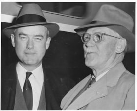
Edgar G. Burton and Charles Luther Burton arriving in Vancouver
https://search.heritageburnaby.ca/link/museumdescription17259
- Repository
- Burnaby Village Museum
- Date
- May 1954
- Collection/Fonds
- Simpsons-Sears Limited Burnaby fonds
- Description Level
- Item
- Physical Description
- 1 photograph : b&w ; 20.5 x 25.5 cm
- Scope and Content
- Photograph of (left to right) Edgar G. Burton, President of Simpsons-Sears Ltd. and Charles Luther Burton (Chairman of the Board, Simpsons-Sears) arriving on a Great Northern train in Vancouver.
- Repository
- Burnaby Village Museum
- Collection/Fonds
- Simpsons-Sears Limited Burnaby fonds
- Description Level
- Item
- Physical Description
- 1 photograph : b&w ; 20.5 x 25.5 cm
- Scope and Content
- Photograph of (left to right) Edgar G. Burton, President of Simpsons-Sears Ltd. and Charles Luther Burton (Chairman of the Board, Simpsons-Sears) arriving on a Great Northern train in Vancouver.
- Subjects
- Transportation - Rail
- Geographic Access
- Vancouver
- Accession Code
- BV021.26.9
- Access Restriction
- No restrictions
- Reproduction Restriction
- May be restricted by third party rights
- Date
- May 1954
- Media Type
- Photograph
- Scan Resolution
- 600
- Scan Date
- 2021-09-21
- Notes
- Title based on contents of photograph
- Photograph was removed from original scrapbook with newspaper clippings, photographs and ephemera
Images

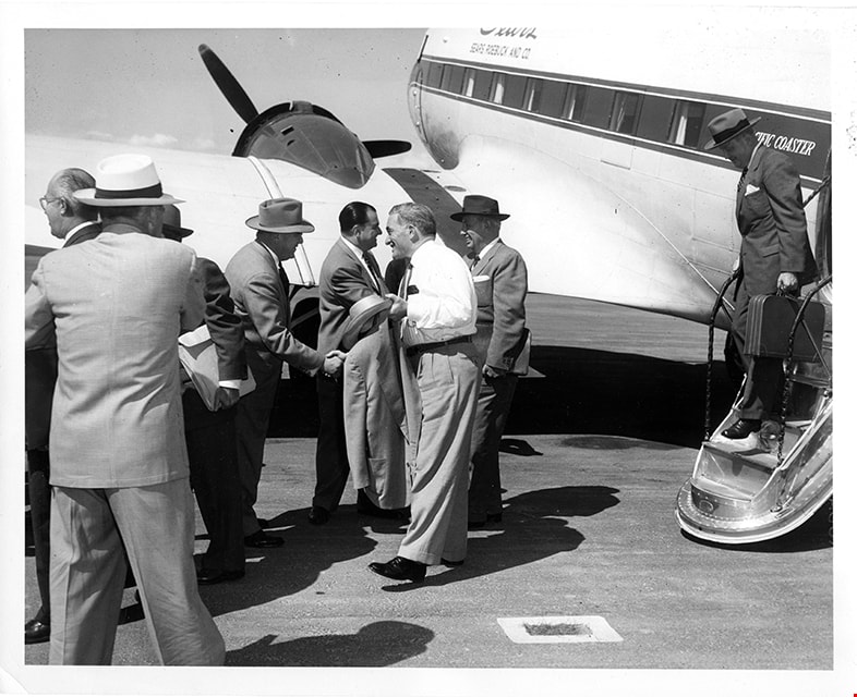
Executive and managers arriving at Vancouver Airport
https://search.heritageburnaby.ca/link/museumdescription17345
- Repository
- Burnaby Village Museum
- Date
- 12 Jul. 1954
- Collection/Fonds
- Simpsons-Sears Limited Burnaby fonds
- Description Level
- Item
- Physical Description
- 1 photograph : b&w ; 20.5 x 25.5 cm
- Scope and Content
- Photograph of unidentified exectuive and managers arriving on the Sears-Roebuck "Pacific Coaster" at Vancouver Airport July 12, 1954.
- Repository
- Burnaby Village Museum
- Collection/Fonds
- Simpsons-Sears Limited Burnaby fonds
- Description Level
- Item
- Physical Description
- 1 photograph : b&w ; 20.5 x 25.5 cm
- Scope and Content
- Photograph of unidentified exectuive and managers arriving on the Sears-Roebuck "Pacific Coaster" at Vancouver Airport July 12, 1954.
- Subjects
- Transportation - Air
- Names
- Simpsons-Sears Limited
- Geographic Access
- Vancouver
- Accession Code
- BV021.26.96
- Access Restriction
- No restrictions
- Reproduction Restriction
- May be restricted by third party rights
- Date
- 12 Jul. 1954
- Media Type
- Photograph
- Photographer
- Croton Studio Limited
- Notes
- Title based on contents of photograph
- Photograph was removed from original scrapbook with newspaper clippings, photographs and ephemera
- Stamp on verso of photograph reads: "Croton STUDIO / NEW WESTMINSTER B.C."
- For list of names of executive, managers and flight crew that flew on this aircraft see: BV021.26.95
Images
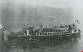
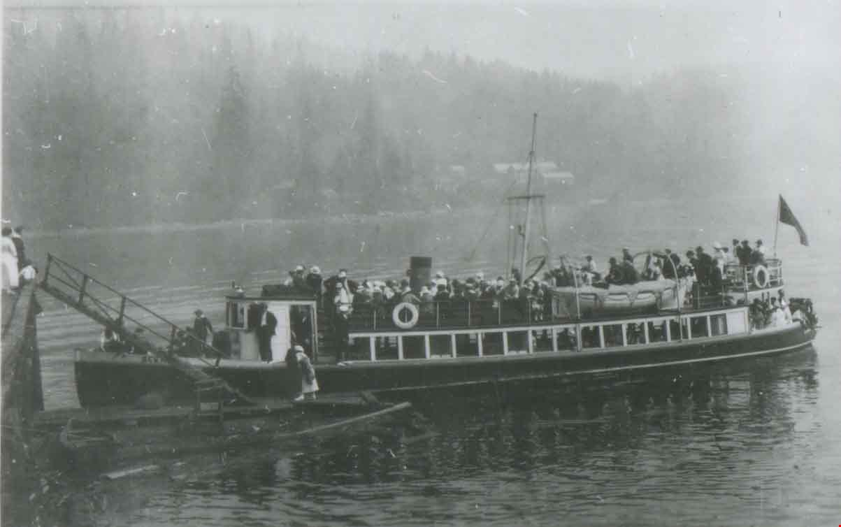
Ferry from Port Moody to Vancouver
https://search.heritageburnaby.ca/link/archivedescription37706
- Repository
- City of Burnaby Archives
- Date
- 1923 (date of original), copied 1991
- Collection/Fonds
- Burnaby Historical Society fonds
- Description Level
- Item
- Physical Description
- 1 photograph : b&w ; 3.3 x 5.1 cm print on contact sheet 20.2 x 25.3 cm
- Scope and Content
- Photograph of the "scenic" ferry from Port Moody to Vancouver through the Burrard Inlet.
- Repository
- City of Burnaby Archives
- Date
- 1923 (date of original), copied 1991
- Collection/Fonds
- Burnaby Historical Society fonds
- Subseries
- Burnaby Image Bank subseries
- Physical Description
- 1 photograph : b&w ; 3.3 x 5.1 cm print on contact sheet 20.2 x 25.3 cm
- Description Level
- Item
- Record No.
- 370-294
- Access Restriction
- No restrictions
- Reproduction Restriction
- No known restrictions
- Accession Number
- BHS1999-03
- Scope and Content
- Photograph of the "scenic" ferry from Port Moody to Vancouver through the Burrard Inlet.
- Media Type
- Photograph
- Notes
- Title based on contents of photograph
- 1 b&w copy negative accompanying
- Historic Neighbourhood
- Barnet (Historic Neighbourhood)
- Planning Study Area
- Burnaby Mountain Area
Images

Fire insurance key plan - Greater Vancouver - Volume XIX - Municipality of Burnaby
https://search.heritageburnaby.ca/link/museumdescription17799
- Repository
- Burnaby Village Museum
- Date
- 1927
- Collection/Fonds
- Burnaby Village Museum Map collection
- Description Level
- Item
- Physical Description
- 1 plan on 1 sheet : col. lithographic print ; 64 x 54 cm
- Scope and Content
- Item consists of a one page fire insurance key plan titled "Greater Vancouver / Volume XIX / Municipality / of Burnaby / Key Plan" surveyed May 1927. Key plan from compilation, "Insurance Plans of Greater Vancouver Plan No. 11, Volumes 15 to 19 Burnaby".
- Repository
- Burnaby Village Museum
- Collection/Fonds
- Burnaby Village Museum Map collection
- Description Level
- Item
- Physical Description
- 1 plan on 1 sheet : col. lithographic print ; 64 x 54 cm
- Material Details
- Scale [1:6000]
- Scope and Content
- Item consists of a one page fire insurance key plan titled "Greater Vancouver / Volume XIX / Municipality / of Burnaby / Key Plan" surveyed May 1927. Key plan from compilation, "Insurance Plans of Greater Vancouver Plan No. 11, Volumes 15 to 19 Burnaby".
- Publisher
- Plan Department of Fire Branch of British Columbia Underwriters' Association
- Accession Code
- BV987.1.70
- Access Restriction
- No restrictions
- Reproduction Restriction
- May be restricted by third party rights
- Date
- 1927
- Media Type
- Cartographic Material
- Historic Neighbourhood
- Fraser Arm (Historic Neighbourhood)
- Planning Study Area
- Big Bend Area
- Scan Resolution
- 400
- Scan Date
- 2021-11-17
- Notes
- Title based on contents of item
- Scale 500 feet = 1 inch
- These plans were removed from a bound book with labels on cover page reading: "Plan No. 90 / THIS INSURANCE PLAN / of / Vancouver VOLUME "8" / IN THE PROPERTY OF THE / British Columbia Insurance Underwriter's Association / Vancouver B.C. / AND IS LOANED / MELVILLE F. THOMSON CO. .../ Date May 26th, 1934"; / "Plan No. 74 / THIS INSURANCE PLAN / OF / VANCOUVER VOLUME "9"" / Plan No. 11 / THIS INSURANCE PLAN / OF / BURNABY VOLUMES 15-19" / "THIS PLAN IS THE PROPERTY OF / THE / BRITISH LAW INSURANCE COMPANY / LIMITED"
- Does not include the corresponding key plan page or associated plans numbered 1901 to 1914
- Contact Burnaby Village Museum to view associated fire insurance plans
Zoomable Images

Fire insurance key plan - Greater Vancouver - Volume XIX - Municipality of Burnaby, 1927
Zoom into Image
Fire insurance key plan - Greater Vancouver - Volume XVI - Municipality of Burnaby
https://search.heritageburnaby.ca/link/museumdescription17796
- Repository
- Burnaby Village Museum
- Date
- 1927
- Collection/Fonds
- Burnaby Village Museum Map collection
- Description Level
- Item
- Physical Description
- 2 plans on 2 sheets: col. lithographic print ; 64 x 54 cm
- Scope and Content
- Item consists of a two page fire insurance key plan titled "Greater Vancouver / Volume XVI / Municipality / of Burnaby / Key Plan" surveyed May 1927. Volume XVI includes a two page Key Plan (C and D). .
- Repository
- Burnaby Village Museum
- Collection/Fonds
- Burnaby Village Museum Map collection
- Description Level
- Item
- Physical Description
- 2 plans on 2 sheets: col. lithographic print ; 64 x 54 cm
- Scope and Content
- Item consists of a two page fire insurance key plan titled "Greater Vancouver / Volume XVI / Municipality / of Burnaby / Key Plan" surveyed May 1927. Volume XVI includes a two page Key Plan (C and D). .
- Publisher
- Plan Department of Fire Branch of British Columbia Underwriters Association
- Accession Code
- BV987.1.70
- Access Restriction
- No restrictions
- Reproduction Restriction
- May be restricted by third party rights
- Date
- 1927
- Media Type
- Cartographic Material
- Scan Resolution
- 400
- Scan Date
- 11/17/2021
- Notes
- Title based on contents of item
- Item "GREATER VANCOUVER / VOLUME XVI / MUNICIPALITY OF / BURNABY / KEY PLAN" does not include associated numbered plans (1601 to 1651)
- These plans were removed from a bound book with labels on cover page reading: "Plan No. 90 / THIS INSURANCE PLAN / of / Vancouver VOLUME "8" / IN THE PROPERTY OF THE / British Columbia Insurance Underwriter's Association / Vancouver B.C. / AND IS LOANED / MELVILLE F. THOMSON CO. .../ Date May 26th, 1934"; / "Plan No. 74 / THIS INSURANCE PLAN / OF / VANCOUVER VOLUME "9"" / Plan No. 11 / THIS INSURANCE PLAN / OF / BURNABY VOLUMES 15-19" / "THIS PLAN IS THE PROPERTY OF / THE / BRITISH LAW INSURANCE COMPANY / LIMITED"
Zoomable Images

Fire insurance key plan - Greater Vancouver - Volume XVI - Municipality of Burnaby, 1927
Zoom into Image
Fire insurance plans - Greater Vancouver - Volume XVIII - Municipality of Burnaby
https://search.heritageburnaby.ca/link/museumdescription17798
- Repository
- Burnaby Village Museum
- Date
- 1927-1950
- Collection/Fonds
- Burnaby Village Museum Map collection
- Description Level
- Item
- Physical Description
- 22 plans on 12 sheets : col. lithographic print ; 64 x 54 cm
- Scope and Content
- Item consists of fire insurance plans titled "Greater Vancouver / Volume XVIII / Municipality / of Burnaby" surveyed May 1927, revised in October 1940 and September 1950. Includes a two page key plan (G and H) and twenty associated plans numbered; 1801; 1802; 1803; 1804; 1805; 1806; 1807; 1808; 18…
- Repository
- Burnaby Village Museum
- Collection/Fonds
- Burnaby Village Museum Map collection
- Description Level
- Item
- Physical Description
- 22 plans on 12 sheets : col. lithographic print ; 64 x 54 cm
- Material Details
- Scales between [1:600] and [1:6000]
- Scope and Content
- Item consists of fire insurance plans titled "Greater Vancouver / Volume XVIII / Municipality / of Burnaby" surveyed May 1927, revised in October 1940 and September 1950. Includes a two page key plan (G and H) and twenty associated plans numbered; 1801; 1802; 1803; 1804; 1805; 1806; 1807; 1808; 1809; 1810; 1811; 1812; 1813; 1814; 1815; 1819; 1820; 1821; 1822 and 1832.
- Publisher
- Plan Department of Fire Branch of British Columbia Underwriters' Association
- Accession Code
- BV987.1.70
- Access Restriction
- No restrictions
- Reproduction Restriction
- May be restricted by third party rights
- Date
- 1927-1950
- Media Type
- Cartographic Material
- Scan Resolution
- 400
- Scan Date
- 11/17/2021
- Notes
- Title based on contents of item
- Scale 1 inch = 50 feet
- These plans were removed from a bound book with labels on cover page reading: "Plan No. 90 / THIS INSURANCE PLAN / of / Vancouver VOLUME "8" / IN THE PROPERTY OF THE / British Columbia Insurance Underwriter's Association / Vancouver B.C. / AND IS LOANED / MELVILLE F. THOMSON CO. .../ Date May 26th, 1934"; / "Plan No. 74 / THIS INSURANCE PLAN / OF / VANCOUVER VOLUME "9"" / Plan No. 11 / THIS INSURANCE PLAN / OF / BURNABY VOLUMES 15-19" / "THIS PLAN IS THE PROPERTY OF / THE / BRITISH LAW INSURANCE COMPANY / LIMITED"
- Contact Burnaby Village Museum to view associated fire insurance plans
Fire insurance plans - Greater Vancouver - Volume XVII - Municipality of Burnaby
https://search.heritageburnaby.ca/link/museumdescription17797
- Repository
- Burnaby Village Museum
- Date
- 1927-1950
- Collection/Fonds
- Burnaby Village Museum Map collection
- Description Level
- Item
- Physical Description
- 4 plans on 4 sheets : col. lithographic prints
- Scope and Content
- Item consists of fire insurance plans titled "Greater Vancouver / Volume XVII / Municipality / of Burnaby" surveyed May 1927, revised in October 1940 and September 1950. Includes a two page key plan (E and F) and two associated plans numbered 1729 and 1738 (located within District Lot 35).
- Repository
- Burnaby Village Museum
- Collection/Fonds
- Burnaby Village Museum Map collection
- Description Level
- Item
- Physical Description
- 4 plans on 4 sheets : col. lithographic prints
- Scope and Content
- Item consists of fire insurance plans titled "Greater Vancouver / Volume XVII / Municipality / of Burnaby" surveyed May 1927, revised in October 1940 and September 1950. Includes a two page key plan (E and F) and two associated plans numbered 1729 and 1738 (located within District Lot 35).
- Publisher
- Plan Department of Fire Branch of British Columbia Underwriters' Association
- Accession Code
- BV987.1.70
- Access Restriction
- No restrictions
- Reproduction Restriction
- May be restricted by third party rights
- Date
- 1927-1950
- Media Type
- Cartographic Material
- Historic Neighbourhood
- Central Park (Historic Neighbourhood)
- Planning Study Area
- Garden Village Area
- Scan Resolution
- 400
- Scan Date
- 2021-11-17
- Notes
- Title based on contents of item
- These plans were removed from a bound book with labels on cover page reading: "Plan No. 90 / THIS INSURANCE PLAN / of / Vancouver VOLUME "8" / IN THE PROPERTY OF THE / British Columbia Insurance Underwriter's Association / Vancouver B.C. / AND IS LOANED / MELVILLE F. THOMSON CO. .../ Date May 26th, 1934"; / "Plan No. 74 / THIS INSURANCE PLAN / OF / VANCOUVER VOLUME "9"" / Plan No. 11 / THIS INSURANCE PLAN / OF / BURNABY VOLUMES 15-19" / "THIS PLAN IS THE PROPERTY OF / THE / BRITISH LAW INSURANCE COMPANY / LIMITED"
- Contact Burnaby Village Museum to view associated fire insurance plans XVIII