Narrow Results By
Subject
- Education 1
- Environmental Issues 1
- Environmental Issues - Environmental Protection 1
- Events 2
- Geographic Features 1
- Geographic Features - Beaches 2
- Geographic Features - Lakes and Ponds 1
- Geographic Features - Mountains 1
- Geographic Features - Parks 1
- Geographic Features - Streams 2
- Housing 1
- Natural Phenomena - Snow 2
![Interview with Ellen and Bill Schwartz, [1969-2023] (interview content), interviewed 15 May 2023 thumbnail](/media/hpo/_Data/_BVM_Sound_Recordings/Oral_Histories/2023_0016_0006_001.jpg?width=280)
Interview with Ellen and Bill Schwartz
https://search.heritageburnaby.ca/link/museumdescription19602
- Repository
- Burnaby Village Museum
- Date
- [1969-2023] (interview content), interviewed 15 May 2023
- Collection/Fonds
- Burnaby Village Museum fonds
- Description Level
- Item
- Physical Description
- 2 sound recordings (wav) (68 min., 52 sec.) + 1 sound recording (mp3) (68 min., 53 sec.)
- Scope and Content
- Item consists of a recording of an oral history interview with Ellen and Bill Schwartz conducted by Burnaby Village Museum Registrar and Researcher, Eric Damer. 00:00-16:47 Bill and Ellen share where they were born, grew up and went to school as citizens of the United States and how they met in Pe…
- Repository
- Burnaby Village Museum
- Collection/Fonds
- Burnaby Village Museum fonds
- Series
- Museum Oral Histories series
- Subseries
- Many Voices Project Interviews subseries
- Description Level
- Item
- Physical Description
- 2 sound recordings (wav) (68 min., 52 sec.) + 1 sound recording (mp3) (68 min., 53 sec.)
- Material Details
- Interviewer: Eric Damer Interviewees: Ellen and Bill Schwartz Location of Interview: Burnaby Village Museum Interview Date: May 15, 2023 Total Number of tracks: 2 Total Length of all Tracks: 01:08:52 Digital master recordings (wav) were recorded onto two separate audio tracks, edited and merged together and converted to mp3 for access on Heritage Burnaby Photograph information: Bill and Ellen Schwartz.
- Scope and Content
- Item consists of a recording of an oral history interview with Ellen and Bill Schwartz conducted by Burnaby Village Museum Registrar and Researcher, Eric Damer. 00:00-16:47 Bill and Ellen share where they were born, grew up and went to school as citizens of the United States and how they met in Pennsylvania the 1970s. Bill and Ellen explain how in the 1970s, they were discouraged about the current politics in the United States under the Nixon administration and how they were inspired by the “back to the land” ideals, rejecting materialism and wanting an alternative lifestyle. With these ideals in mind, they recall how in 1972 they and a few other friends decided to leave the United States, move to British Columbia with the goal of buying land in the Okanagan or Kootenay region and starting a new lifestyle for themselves. Bill and Ellen recollect how they purchased 20 acres of land in Galena Bay in the Kootenays and how they lived in the area off and on until the early 1980s. They describe how they cleared three acres of land, built a cabin, put in a garden, chicken coop and honey bees. With the challenges of the isolated location and no access to electricity they explain how they decided that they had to live elsewhere in order to make a living. Ellen talks about working as a special education teacher in Revelstoke and Slocan and how Bill obtained his teaching certificate while they lived in Nelson. Bill and Ellen describe themselves as environmentalists and of how they both became active Provincial environmentalists during the construction of the Revelstoke Dam. Bill talks about getting work with the “Energy Van” program talking about energy conservation, renewable energy and recycling. They explain how after their first child was born in 1980, they returned to Galena Bay for about a year and a half until Bill was offered a job with the Department of Energy Conservation which lead them to move to Vancouver. 16:48 – 22:46 Bill and Ellen describe their first few years of living in Vancouver and at University of British Columbia while Ellen completed her master’s degree in creative writing. During this time, they had their second child. They recall how in 1988 how they purchased a house in Burnaby, selecting to live in the Deer Lake neighbourhood. They talk about the benefits of the neighbourhood including; a French immersion school for their children, proximity to the trails around Deer Lake and having transit close by. 22:47 – 33:55 Bill and Ellen talk about their consulting business “Polestar Communications”. A Burnaby based communications consulting firm composed of three people, Ellen and Bill and colleague Richard Banner. They describe how their business got started and some of the projects that they’ve worked on including; BC Hydro’s Power Smart Program, financial literacy curriculum that was introduced in B.C. schools and reports for the Province of British Columbia. Ellen and Bill convey how Bill has been a very active member with the City of Burnaby Environment Committee, the Steering Committee to develop a sustainable environmental strategy for Burnaby, how he’s been awarded for his contributions in coaching youth sports and other areas in which they have both volunteered. 33:56 – 43:07 Ellen describes how she got started in writing educational resources about the environment and how since she completed grad school in 1984, she’s published nineteen books. Ellen conveys how her first book was published and sold to the Province of British Columbia as part of the B.C. educational curriculum on the environment. Ellen talks about some of the children’s books that she’s written and published with themes including; social justice, the labour movement and racism in sports. Ellen describes some of her books and the research that she’s done. 43:08 – 51:04 Ellen and Bill Schwartz reflect on what they like about living in Burnaby. They talk about the benefits of their neighbourhood including; performances at the Shadbolt Centre for the Arts, the Burnaby Blues and Roots Festival, the Burnaby Art Gallery and Deer Lake as well as having access to parks and community centres in Burnaby. 51:05-56:36 Bill and Ellen reflect on their involvement in the Jewish community, considering themselves non-secular Jews. Ellen talks about how they were involved with “Burquest” a Jewish Community Association and how they often observe some of the Jewish holidays including Hanukah and traditions including the Jewish coming of age ritual, bar mitzvah (masc.) and bat mistvah (fem.). Ellen mentions her involvement with the “Jone Betty Stuchner Oy Vey! Funniest Children’s book Award” where she acts a judge and her involvement with the Jewish Book festival and that she is a recipient of the Jewish Book award. 56:37 – 1:08:53 Bill and Ellen reflect on their 35 years living in Burnaby and how they’ve seen it change. They talk about the increased development and density in the city, how they are troubled by a lack of low income housing, the benefits and importance of public transportation and preservation of green space including Burnaby parks.
- History
- Interviewees' biographies: Ellen Schwartz was born in Washington, DC, (1950) but grew up in New Jersey. She attended the Universities of Chicago and Wisconsin before moving to a farm in Pennsylvania, where she met her future husband Bill Schwartz. Bill Schwartz grew up in and around Philadelphia (b. 1947), and attended Pennsylvania State University. After travelling, and discouraged with life in eastern America, he and Ellen decided that British Columbia held better prospects. Bill and Ellen quit their jobs in 1972 and moved to the Kootenay region where they adopted a “back to the land” lifestyle, a very new experience for both of them. After eight years of modest success, and occasional work in nearby towns, they opted to return to Vancouver where Bill had work and where they could raise a family more easily. They rented in Vancouver for a few years before moving to family housing at UBC, while Ellen studied creative writing. Bill founded a communications and writing company, and in 1988 they purchased a home in Burnaby. Ellen launched a new career as a writer, mainly for children young adults. Both were active in their careers, raising a family, and participating in local social and political activities. Interviewer biography: Eric Damer is a Burnaby Village Museum Interpreter, Museum Registrar, Researcher and Blacksmith. Eric pounded hot steel for the first time in 1977 in junior high. Fifteen years later, he joined Burnaby Village Museum where he has smithed for three decades. He also provides historical research for museum exhibits and special projects. Outside the museum, Eric is a social historian with a special interest in educational history.
- Creator
- Burnaby Village Museum
- Subjects
- Education
- Environmental Issues
- Environmental Issues - Environmental Protection
- Geographic Features
- Geographic Features - Parks
- Housing
- Occupations
- Occupations - Entrepreneurs
- Occupations - Writers
- Persons - Volunteers
- Persons - Jewish Canadians
- Social Issues
- Social Issues - Racism
- Religions
- Religions - Judaism
- Names
- Schwartz, William "Bill"
- Schwartz, Ellen
- City of Burnaby
- Polestar Communications
- British Columbia Hydro and Power Authority
- Responsibility
- Damer, Eric
- Accession Code
- BV023.16.6
- Access Restriction
- No restrictions
- Reproduction Restriction
- No known restrictions
- Date
- [1969-2023] (interview content), interviewed 15 May 2023
- Media Type
- Sound Recording
- Historic Neighbourhood
- Burnaby Lake (Historic Neighbourhood)
- Planning Study Area
- Burnaby Lake Area
- Notes
- Title based on contents of item
- Transcription available on Heritage Burnaby
Images
![Interview with Ellen and Bill Schwartz, [1969-2023] (interview content), interviewed 15 May 2023 thumbnail](/media/hpo/_Data/_BVM_Sound_Recordings/Oral_Histories/2023_0016_0006_001.jpg)
Documents
Audio Tracks
Interview with Ellen and Bill Schwartz, [1969-2023] (interview content), interviewed 15 May 2023
Interview with Ellen and Bill Schwartz, [1969-2023] (interview content), interviewed 15 May 2023
https://search.heritageburnaby.ca/media/hpo/_Data/_BVM_Sound_Recordings/Oral_Histories/2023_0016_0006_003.mp3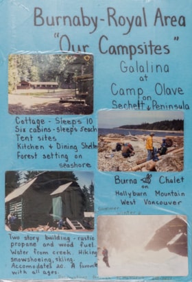
Burnaby - Royal Area "Our Campsites"
https://search.heritageburnaby.ca/link/museumdescription4944
- Repository
- Burnaby Village Museum
- Date
- [ca. 1975]
- Collection/Fonds
- Burnaby Girl Guides fonds
- Description Level
- Item
- Physical Description
- 1 poster : 4 photographs : col. + textual record mounted on board 28 x 40.5 cm and laminated
- Scope and Content
- Item consists of a handwritten poster titled "Burnaby - Royal Area / "Our Campsites"" with four colour photographs of Girl Guide campsites in Sechelt and West Vancouver. Handwritten annotations describe each photograph from the top right to left "Galalina / at / Camp Olave / on / Sechelt Peninsu…
- Repository
- Burnaby Village Museum
- Collection/Fonds
- Burnaby Girl Guides fonds
- Description Level
- Item
- Physical Description
- 1 poster : 4 photographs : col. + textual record mounted on board 28 x 40.5 cm and laminated
- Scope and Content
- Item consists of a handwritten poster titled "Burnaby - Royal Area / "Our Campsites"" with four colour photographs of Girl Guide campsites in Sechelt and West Vancouver. Handwritten annotations describe each photograph from the top right to left "Galalina / at / Camp Olave / on / Sechelt Peninsula" "Cottage - sleeps 10 / Six cabins - sleeps 5each / Tent sites / Kitchen & Dining Shelter / Forest setting on / seashore" "Burna [bee] Chalet / on / Hollyburn Mountain / West Vancouver / Summer / Winter" "Two story building - rustic / propane and wood fuel / Water from creek. Hiking / snowshoeing, skiing. / Accomodates 20. A favourite / with all ages" "Reservations through M. Matthews ___-____"
- Subjects
- Organizations - Girls' Societies and Clubs
- Recreational Activities - Camping
- Natural Phenomena - Snow
- Geographic Features - Beaches
- Names
- Girl Guides of Canada
- Accession Code
- BV015.35.213
- Access Restriction
- No restrictions
- Reproduction Restriction
- May be restricted by third party rights
- Date
- [ca. 1975]
- Media Type
- Photograph
- Textual Record
- Notes
- Transcribed title
Images
Campsite Collection
https://search.heritageburnaby.ca/link/museumdescription4589
- Repository
- Burnaby Village Museum
- Date
- [between 1958 and 2002]
- Collection/Fonds
- Burnaby Girl Guides fonds
- Description Level
- File
- Physical Description
- 1 file : 33 photographs + textual records + other material
- Scope and Content
- File consists of photographs, an illustration, ephemera and histories about Burnaby Guiding Camps including Burnaby Chalet on Cypress Mountain, Galalina Camp at Camp Olave near Sechelt B.C., Burnaby Guide Camp at Wilson Creek and a few postcards of Camp Tsoona, Rosedale B.C. A collection of written…
- Repository
- Burnaby Village Museum
- Collection/Fonds
- Burnaby Girl Guides fonds
- Description Level
- File
- Physical Description
- 1 file : 33 photographs + textual records + other material
- Scope and Content
- File consists of photographs, an illustration, ephemera and histories about Burnaby Guiding Camps including Burnaby Chalet on Cypress Mountain, Galalina Camp at Camp Olave near Sechelt B.C., Burnaby Guide Camp at Wilson Creek and a few postcards of Camp Tsoona, Rosedale B.C. A collection of written material provides historical background regarding the two storey cabin on Hollyburn Mountain. The cabin was purchased by Burnaby Girl Guides in 1964 and appropriately named Burnaby Chalet. A Chalet Committee was formed with representatives from each Division appointing a Chalet Manageress to handle reservations. This typical ski cabin can accomodate up to 40 people. The file also includes a "Campsite Log Book" for the Hollyburn Chalet with handwritten notes from 1981 and 1982, an embroidered triangular shaped badge "Burnaby Royal / Girl Guides / Hollyburn Chalet" and a dedication ceremony program for "Burnaby Guide Camp / June 8, 1958" (Wilson Creek).
- Subjects
- Organizations - Girls' Societies and Clubs
- Recreational Activities - Camping
- Natural Phenomena - Snow
- Geographic Features - Beaches
- Names
- Girl Guides of Canada
- Accession Code
- BV015.35.161
- Access Restriction
- No restrictions
- Reproduction Restriction
- May be restricted by third party rights
- Date
- [between 1958 and 2002]
- Media Type
- Photograph
- Textual Record
- Notes
- Transcribed title
Men at Heritage Village
https://search.heritageburnaby.ca/link/museumdescription2507
- Repository
- Burnaby Village Museum
- Date
- 11 April 1971
- Collection/Fonds
- Donald Copan collection
- Description Level
- Item
- Physical Description
- 1 photograph : b&w ; 8.9 x 8.9 cm
- Scope and Content
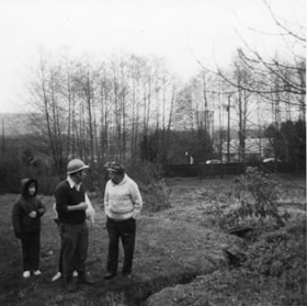
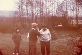
- Photograph of two unidentifed men (one in hard hat) and two children standing in a field next to a creek bed during the official sod-turning for Heritage Village (now Burnaby Village Museum), April 11, 1971. Burnaby fire hall number is visible in the distance behind trees.
- Repository
- Burnaby Village Museum
- Collection/Fonds
- Donald Copan collection
- Series
- Copan album series
- Description Level
- Item
- Physical Description
- 1 photograph : b&w ; 8.9 x 8.9 cm
- Scope and Content
- Photograph of two unidentifed men (one in hard hat) and two children standing in a field next to a creek bed during the official sod-turning for Heritage Village (now Burnaby Village Museum), April 11, 1971. Burnaby fire hall number is visible in the distance behind trees.
- Subjects
- Events
- Geographic Features - Streams
- Names
- Burnaby Village Museum
- Accession Code
- BV005.54.556
- Access Restriction
- No restrictions
- Reproduction Restriction
- May be restricted by third party rights
- Date
- 11 April 1971
- Media Type
- Photograph
- Historic Neighbourhood
- Burnaby Lake (Historic Neighbourhood)
- Planning Study Area
- Morley-Buckingham Area
- Scan Resolution
- 600
- Scan Date
- August 18, 2020
- Scale
- 100
- Notes
- Title based on contents of photograph
Images
Men at on site of Heritage Village
https://search.heritageburnaby.ca/link/museumdescription13669
- Repository
- Burnaby Village Museum
- Date
- 11 April 1971
- Collection/Fonds
- Donald Copan collection
- Description Level
- Item
- Physical Description
- 1 photograph : col. ; 8.9 x 12.7 cm
- Scope and Content
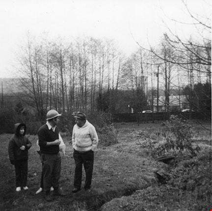
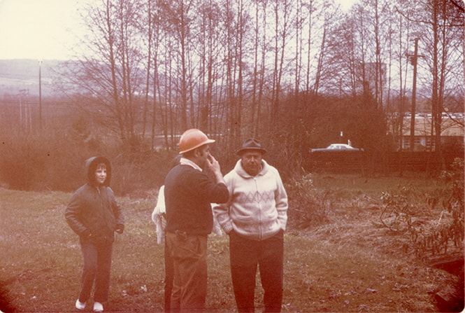
- Photograph of two unidentifed men (one in hard hat) and two children standing in a field next to a creek bed during the official sod-turning for Heritage Village (now Burnaby Village Museum), April 11, 1971. Burnaby fire hall number is visible in the distance behind trees.
- Repository
- Burnaby Village Museum
- Collection/Fonds
- Donald Copan collection
- Series
- Copan album series
- Description Level
- Item
- Physical Description
- 1 photograph : col. ; 8.9 x 12.7 cm
- Scope and Content
- Photograph of two unidentifed men (one in hard hat) and two children standing in a field next to a creek bed during the official sod-turning for Heritage Village (now Burnaby Village Museum), April 11, 1971. Burnaby fire hall number is visible in the distance behind trees.
- Subjects
- Events
- Geographic Features - Streams
- Names
- Burnaby Village Museum
- Accession Code
- BV005.54.575
- Access Restriction
- No restrictions
- Reproduction Restriction
- May be restricted by third party rights
- Date
- 11 April 1971
- Media Type
- Photograph
- Historic Neighbourhood
- Burnaby Lake (Historic Neighbourhood)
- Planning Study Area
- Morley-Buckingham Area
- Scan Resolution
- 600
- Scan Date
- August 18, 2020
- Scale
- 100
- Notes
- Title based on contents of photograph
Images
![Roadway leading to Deer Lake, [1975] thumbnail](/media/hpo/_Data/_BVM_Images/2020/2020_0005_1262_001.jpg?width=280)
Roadway leading to Deer Lake
https://search.heritageburnaby.ca/link/museumdescription14245
- Repository
- Burnaby Village Museum
- Date
- [1975]
- Collection/Fonds
- Century Park Museum Association fonds
- Description Level
- Item
- Physical Description
- 1 photograph : col. slide ; 35 mm
- Scope and Content
- Photograph of roadway leading to Deer Lake and Century Park (Deer Lake Park).
- Repository
- Burnaby Village Museum
- Collection/Fonds
- Century Park Museum Association fonds
- Description Level
- Item
- Physical Description
- 1 photograph : col. slide ; 35 mm
- Scope and Content
- Photograph of roadway leading to Deer Lake and Century Park (Deer Lake Park).
- Names
- Burnaby Village Museum
- Geographic Access
- Deer Lake Park
- Accession Code
- BV020.5.1262
- Access Restriction
- No restrictions
- Reproduction Restriction
- No known restrictions
- Date
- [1975]
- Media Type
- Photograph
- Scan Resolution
- 2400
- Scan Date
- 20-Oct-2020
- Scale
- 100
- Notes
- Title based on contents of photograph
- Stamp on slide frame reads: "35_APR_75V1"
Images
![Roadway leading to Deer Lake, [1975] thumbnail](/media/hpo/_Data/_BVM_Images/2020/2020_0005_1262_001.jpg)
Royal Bank on barge leaving Britannia Beach
https://search.heritageburnaby.ca/link/museumdescription12550
- Repository
- Burnaby Village Museum
- Date
- April 1976
- Collection/Fonds
- Burnaby Village Museum fonds
- Description Level
- Item
- Physical Description
- 1 photograph : col. slide ; 35 mm
- Scope and Content
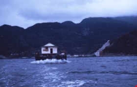
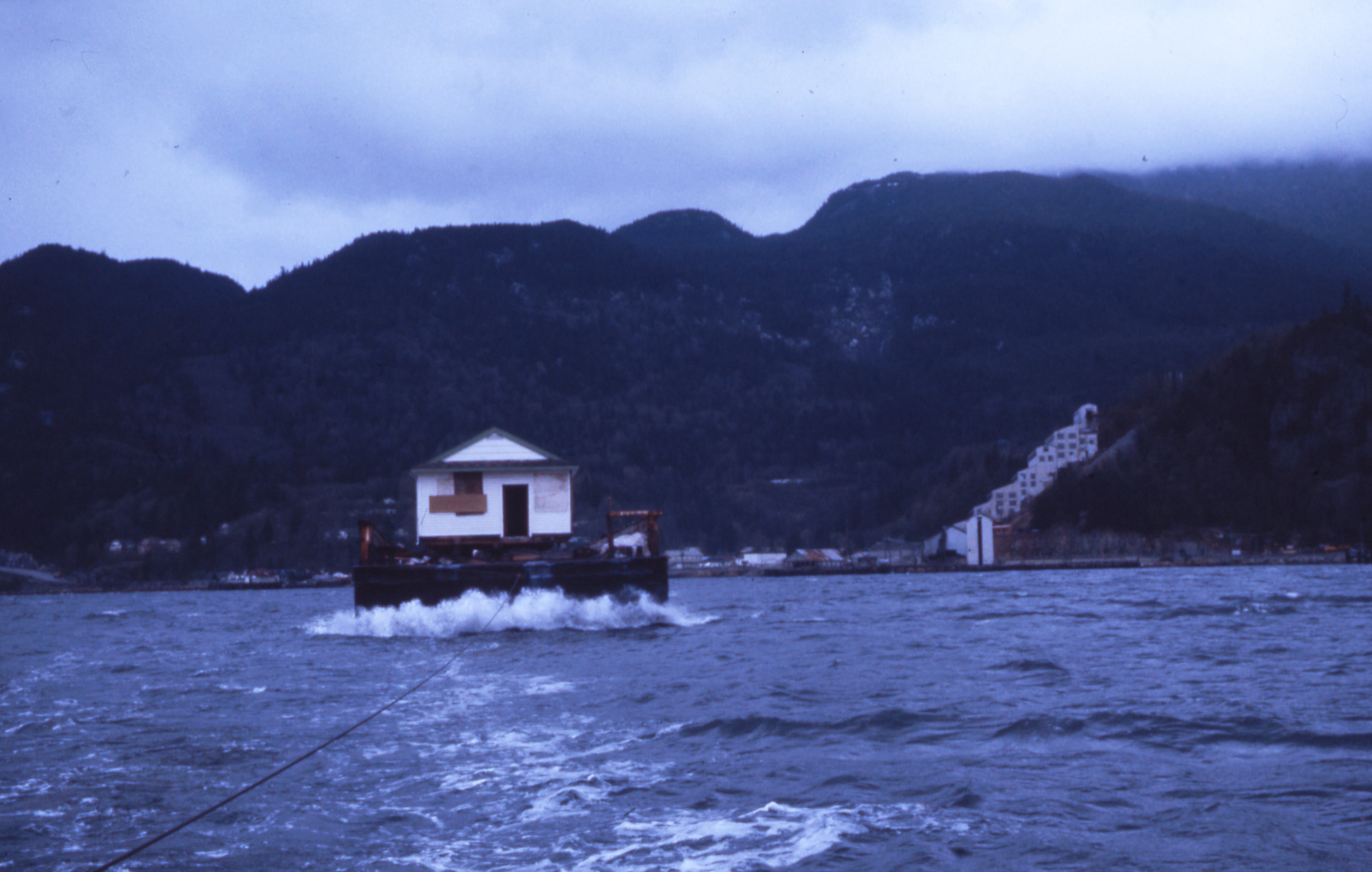
- Photograph of the Royal Bank building on a barge, being pulled by a tug boat through Howe Sound, just outside Britannia Beach. The Britannia Beach, Britannia Mine and Sḵwx̱wú7mesh are visible in the background. The barge provided by Seaspan International travelled to the Ocean Cement's docks near t…
- Repository
- Burnaby Village Museum
- Collection/Fonds
- Burnaby Village Museum fonds
- Series
- Royal Bank exhibit series
- Description Level
- Item
- Physical Description
- 1 photograph : col. slide ; 35 mm
- Scope and Content
- Photograph of the Royal Bank building on a barge, being pulled by a tug boat through Howe Sound, just outside Britannia Beach. The Britannia Beach, Britannia Mine and Sḵwx̱wú7mesh are visible in the background. The barge provided by Seaspan International travelled to the Ocean Cement's docks near the Queensborough bridge in New Westminster before being transported by truck to Heritage Village in Burnaby (Burnaby Village Museum).
- Subjects
- Geographic Features - Mountains
- Accession Code
- BV020.5.211
- Access Restriction
- No restrictions
- Reproduction Restriction
- No known restrictions
- Date
- April 1976
- Media Type
- Photograph
- Scan Resolution
- 2400
- Scan Date
- 2/3/2020
- Scale
- 100
- Notes
- Title based on contents of photograph
Images
![Survey and Subdivision plans in New Westminster District Group 1 – Burnaby
, [1861]-[1910] thumbnail](/media/hpo/_Data/_BVM_Cartographic_Material/1977/1977_0093_0019a_001.jpg?width=280)
Survey and Subdivision plans in New Westminster District Group 1 – Burnaby
https://search.heritageburnaby.ca/link/museumdescription6988
- Repository
- Burnaby Village Museum
- Date
- [1861]-[1910]
- Collection/Fonds
- Burnaby Village Museum Map collection
- Description Level
- File
- Physical Description
- 14 plans : 3 plans : black ink on paper hand col. + 7 plans : black ink on paper + 4 plans : graphite on paper mounted on 2 sides of cardboard 76 x 102 cm
- Scope and Content
- Item consists of a large board of four New Westminster District Gp 1 - subdivision plans mounted on one side and ten New Westminster District Gp 1 - subdivision plans mounted on the other side. Side A: 1. "Plan /of / Lots 166A, 166 and 167 /, Gr.1, N.W.D. / Showing Misconstructed Roads in Gree…
- Repository
- Burnaby Village Museum
- Collection/Fonds
- Burnaby Village Museum Map collection
- Description Level
- File
- Physical Description
- 14 plans : 3 plans : black ink on paper hand col. + 7 plans : black ink on paper + 4 plans : graphite on paper mounted on 2 sides of cardboard 76 x 102 cm
- Material Details
- Scales [between 1:2376 and 1:7920]
- Index number on edge of board reads: "19"
- Scope and Content
- Item consists of a large board of four New Westminster District Gp 1 - subdivision plans mounted on one side and ten New Westminster District Gp 1 - subdivision plans mounted on the other side. Side A: 1. "Plan /of / Lots 166A, 166 and 167 /, Gr.1, N.W.D. / Showing Misconstructed Roads in Green / 5 chs = 1 in.". (plan is drawn in black ink and hand coloured in red, green and orange ink). A section in the centre of the plan is coloured in red ink and identified as "C.S. Richmond" running from the North Arm of Fraser River to Wiggins Road and divided by "New Wiggins Rd. (as gazetted)" (coloured in orange ink) and two"Constructed Road(s)" (coloured in green ink). Plan is initialed by: "RB" [sic] (in blue pencil crayon) 2. Plan of / Subdivision of / Lot 166 / Group One / New Westminster District / Scale 4 chs = 1 in. / Map No 524". Plan is drawn in graphite and signed by "Surrig [sic] Welhams [sic] / P.L.S." Plan is initialed by: "RB" [sic] (in blue pencil crayon) 3. Plan of "Survey / of Highway / For / Burnaby Council / in / Lots 13 _14 / Group One / Scale 4 chs = 1 in." Signed by "Albert J. Hill, P.L.S." Caribou Street and Caribou Road run through the centre of the plan. Plan is stamped: "Albert J. Hill, Civil Engineer / and / Provincial Land Surveyor, / New Westminster, / B.C.". Plan is initialed by: "RB" [sic] (in blue pencil crayon) 4. A Plan of Lots 166A, 166 and 167, Group One, New Westminster District (drawn in graphite). A section in the centre of the plan is identified as "C.S. Richmond" running from the North Arm of Fraser River and divided by "New Wiggins Rd. (as gazetted)" and two "Constructed Road(s)". Plan is initialed by: "RB" [sic] (in blue pencil crayon) Side B: 1. Small plan drawn in black ink (no title) identifying lots north of the "North Arm" of the Fraser River. Lots identified include: Lot 99, Lot 98, Lot 157, Lot 158, Lot 163, Lot 162, Lot 159, Lot 163, Lot 162, Lot 165, Lot 166A, Lot 155B, Lot 155A and Lot 159. "Scale 40 chains to one inch" . Plan is initialed by: "RB" [sic] (in blue pencil crayon) (Geographic location: Burnaby) 2. Small plan drawn in black ink (no title) identifying lots north of the North Arm of the Fraser River as "Lots 155, 155A, 155B, 155C, 162, 163, 164, 165, 166A and 167". Plan is initialed by: "RB" [sic] (in blue pencil crayon) (Geographic location: Burnaby) 3. Small plan drawn in black ink (no title) which identifies "Lot 151 / Reserve/ for / Race Course"; "Reserve / 64 A / L. 152 G.1"; and other Lots: 32, 33, 34, 35, 36, 38, 39. The plan is signed "Surveyor G.Turn [sic] July / 61 / from Vol 40 R.L. notes [sic]" Plan is stamped: "Albert J. Hill, Civil Engineer / and / Provincial Land Surveyor, / New Westminster, / B.C." Plan is initialed by: "RB" [sic] (in blue pencil crayon) (Geographic location: Burnaby) 4. Small plan drawn in black in with faded red colouring on centre lot identified as "Lot 34" running north from "Vancouver Road" . Plan is stamped: "Albert J. Hill, Civil Engineer / and / Provincial Land Surveyor, / New Westminster, / B.C." Plan is initialed by: "RB" [sic] (in blue pencil crayon) (Geographic location: Burnaby) 5. Plan drawn in graphite and identified as "Lot 98, Gr.1," along with the intials "RB" [sic] (both are handwritten in blue crayon pencil on top of plan) The B.C.E.Railway is identified running through the plan along with Jubilee Road and Royal Oak Road. The plan is signed with the name "Wm. Murray" and the Plan is stamped: "Albert J. Hill, Civil Engineer / and / Provincial Land Surveyor, / New Westminster, / B.C.". (Geographic location: Burnaby) 6. Plan drawn in graphite identified as "Port Lot 13, Gr.1" along with the intials "RB" [sic] (both are handwritten in blue crayon pencil on top of plan) Plan is stamped: "Albert J. Hill, Civil Engineer / and / Provincial Land Surveyor, / New Westminster, / B.C.". (Geographic location: Burnaby) 7.Plan drawn in black ink and identified as "Lot 98 G.1" along with the intials "RB" [sic] (both are handwritten in blue crayon pencil on top of plan). A "Road Reservation" is identified running north between "Electric Tramway" and connecting with "Royal Oak Road". Plan is stamped: "Albert J. Hill, Civil Engineer / and / Provincial Land Surveyor, / New Westminster, / B.C." (Geographic location: Burnaby) 8. Plan drawn in black ink and divided into two sections, the upper plan is identified as "Portion / Lots 100 / area / 101, Gr.1" and the lower plan is identified as "Portion L. 3 G. 1" along with the intials "RB" [sic] (these identifiers are handwritten in blue crayon pencil on top of the plan). Portions of Lot 100 and Lot 101 are each divided into 6 sections and the Portion of Lot 3 plan is divided into 24 sections. The plan includes a note in black ink that reads: " Received from Wm Fromme [sic] / from Wm. Trapp / Nov. 28, 1895 / A. J. T...[sic]". (Geographic location: Burnaby) 9. Plan drawn in black ink (no title) identifying soil, buildings and geographic features in southern Burnaby. The plan is bordered by "New Westminster City" (Tenth Avenue and DL 172) to the south east and DL 173 to the south, DL 158 to the west and the B.C.E. Tramway to the north. Plan includes District Lots: 155A, 158, 159, 171, 160, 53 and 95 and identifies soil, marshland and ravines throughout. Plan identifies the following features: a "Team Road" running through Lots 158 and 159 along with "Fair Orchard Soil / Even Surface Throughout / No Ravines", "Gravel and Shingle" (bottom of Lot 158), "North Arm Road" crossing "Byrne Road" and connecting with "Power House Road" which runs north to connect with "Highland Park Station" and the B.C.E. Tramway, "Power Ho" in the northeast corner of DL 160, a "Brook" connected with a "Deep Ravine" running between DL 53, DL 95 and DL 160 along with "Good Soil" and "Fair Orchard Soil" identified nearby in DL 95. Scale is identified as "10 chs = 1 in." Plan is stamped: "Albert J. Hill, Civil Engineer / and / Provincial Land Surveyor, / New Westminster, / B.C." Plan is initialed by: "RB" [sic] (in blue pencil crayon) (Geographic location: Burnaby) 10. Plan drawn in black ink (no title) with Burnaby Lake and Deer Lake at the centre. The plan is bordered by the following District Lots identified as: 117, 118 and 68 to the west, Lots 80, 79 and 85 to the southwest, Lots 11, 13, and 1 (City of New Westminster) to the south east, the North Road boundary to the east and Lots 8, 56, 57, 59, and 136 to the North. The lower right hand corner of the plan has a small inset which reads: "Burnaby Lake" and "Page 19 R.B. Notes". Plan is initialed by: "RB" [sic] (in blue pencil crayon) (Geographic location: Burnaby)
- Creator
- Hill, Albert James
- Accession Code
- HV977.93.19
- Access Restriction
- No restrictions
- Reproduction Restriction
- No known restrictions
- Date
- [1861]-[1910]
- Media Type
- Cartographic Material
- Scan Resolution
- 300
- Scale
- 72
- Notes
- Title based on contents of file
- Scale is measured in chains. (One chain equals 792 inches)
- The term "Lot" can also refer to a "District Lot”
- Some plans are stamped: "Albert J. Hill, Civil Engineer / and / Provincial Land Surveyor, / New Westminster, / B.C." and intialed: "RB" [sic]
Images
![Survey and Subdivision plans in New Westminster District Group 1 – Burnaby
, [1861]-[1910] thumbnail](/media/hpo/_Data/_BVM_Cartographic_Material/1977/1977_0093_0019a_001.jpg)
