Narrow Results By
Decade
- 2020s 11
- 2010s 12
- 2000s
- 1990s 20
- 1980s 29
- 1970s 68
- 1960s
- 1950s 26
- 1940s 31
- 1930s 27
- 1920s 35
- 1910s 79
- 1900s 55
- 1890s 24
- 1880s 9
- 1870s 3
- 1860s
- 1850s 1
- 1840s 1
- 1830s 1
- 1820s 1
- 1810s 1
- 1800s 1
- 1790s 1
- 1780s 1
- 1770s 1
- 1760s 1
- 1750s 1
- 1740s 1
- 1730s 1
- 1720s 1
- 1710s 1
- 1700s 1
- 1690s 1
- 1680s 1
- 1670s 1
- 1660s 1
- 1650s 1
- 1640s 1
- 1630s 1
- 1620s 1
- 1610s 1
- 1600s 1
Subject
- Buildings 1
- Buildings - Commercial - Grocery Stores 1
- Buildings - Heritage 3
- Buildings - Industrial - Factories 1
- Buildings - Industrial - Saw Mills 2
- Buildings - Residential 1
- Clothing 1
- Crafts 1
- Documentary Artifacts - Architectural Drawings 1
- Documentary Artifacts - Letters and Envelopes 2
- Education 1
- Employment 2
Creator
- Burnaby Community Heritage Commission 1
- Burnaby, Robert, 1828-1878 1
- Burnaby Village Museum 2
- Draper, William Nelson 1
- Friends of Interurban 1223 1
- Gale, Reverend Edward S. 1
- Gardner, James B., 1950- 1
- Girl Guides of Canada 1
- Hill, Albert James 2
- Love Family 1
- Luxton, Donald, 1954- 1
- Malik, Anushay 1
Person / Organization
- British Columbia Electric Railway Company 1
- Burnaby Village Museum 2
- Kapoor Sawmills Limited 1
- Kuyer, Jack 2
- Manhas, Budhan Kaur 2
- Manhas, Ghania Singh 2
- Manhas, Kashmir Singh 2
- Manhas, Lashman Singh 2
- Manhas, Sher Singh 2
- Martin, Elmer Wilson 2
- Parmar, Kalwant Singh "Nadeem" 2
- Parmar, Surjeet Kaur 2
The AAM guide to collections planning
https://search.heritageburnaby.ca/link/museumlibrary6968
- Repository
- Burnaby Village Museum
- Collection
- Reference Collection
- Material Type
- Book
- ISBN
- 0931201888
- Call Number
- 069.5 GAR
- Place of Publication
- Washington, D.C.
- Publisher
- American Association of Museums
- Publication Date
- c2004
- Physical Description
- viii, 93 p. ; 23 cm.
- Library Subject (LOC)
- Museums--Collection management--United States
- Museums--United States--Planning
- Museums--United States--Management
- Notes
- Includes bibliographical references (p. 73-76) and index.
Burnaby's heritage : an inventory of buildings and structures
https://search.heritageburnaby.ca/link/museumlibrary5437
- Repository
- Burnaby Village Museum
- Author
- Luxton, Donald, 1954-
- Wolf, Jim
- Edition
- Rev.
- Publication Date
- 2011
- c2007
- Call Number
- 971.133 LUX COPY 1
Financial assistance for this project was provided by the Government of British Columbia
through the Community Heritage Planning Program
Matching funding was provided by the City of Burnaby
© 2007 City of Burnaby (revised 2011)
Front Cover: Saint John the Divine Church, 1905 [BCA]
Title Page: Looking north
- Repository
- Burnaby Village Museum
- Collection
- Digital Reference Collection
- Material Type
- Book
- ISBN
- 0969282893
- Call Number
- 971.133 LUX COPY 1
- Edition
- Rev.
- Author
- Luxton, Donald, 1954-
- Wolf, Jim
- Place of Publication
- Burnaby, B.C.
- Publisher
- City of Burnaby
- Publication Date
- 2011
- c2007
- Physical Description
- 157 p. : ill. ; 28 cm.
- Library Subject (LOC)
- Architecture
- Historic buildings
- Buildings
- Historic sites
- Subjects
- Buildings
- Buildings - Heritage
- Notes
- Includes bibliographical references and index.
- 2 copies held: copy 1.
Digital Books
In the shadow by the sea : recollections of Burnaby's Barnet Village
https://search.heritageburnaby.ca/link/museumlibrary5173
- Repository
- Burnaby Village Museum
- Publication Date
- c2004
- Call Number
- 971.133 PRI Copy 2
an exceptional job in pulling the project together. Both Bianka Zein-
abova, of the Clerk's Department, and Therese Nielsen of the Planning Department assisted in
word processing and mailing. Michelle Barroca, Records and Information Officer andArilea Sill,
Archivist, retrieved documents from the City of Burnaby
- Repository
- Burnaby Village Museum
- Collection
- Digital Reference Collection
- Reference Collection
- Material Type
- Book
- ISBN
- 0969282885
- Call Number
- 971.133 PRI Copy 2
- Contributor
- Wolf, Jim
- Pride, Harry, 1925-
- Place of Publication
- Burnaby, B.C.
- Publisher
- City of Burnaby
- Publication Date
- c2004
- Physical Description
- 246 p. : ill., maps, ports. ; 28 cm.
- Library Subject (LOC)
- Burnaby (B.C.)--History
- Industries--British Columbia--Burnaby--History
- Barnet Marine Park--Burnaby, B.C.
- Geographic Access
- Barnet Road
- Burrard Inlet
- Notes
- Includes bibliographical references (p. 246) and index.
- "edited by Harry Pride and Jim Wolf"
- Copy 2 of 2
Digital Books
Land of promise : Robert Burnaby's letters from colonial British Columbia, 1858-1863
https://search.heritageburnaby.ca/link/museumlibrary5465
- Repository
- Burnaby Village Museum
- Publication Date
- c2002
- Call Number
- 971.1 BUR COPY 3
), Councillor Dan Johnston, supported the project on behalf
of the citizens of Burnaby.
The City of Burnaby provided valuable staff support through the
Planning Department and Heritage Planner, Bill Rapanos. It was Jim
Wolf, Heritage Planning Assistant, who guided the book project to its
final publication
- Repository
- Burnaby Village Museum
- Collection
- Reference Collection
- Digital Reference Collection
- Material Type
- Book
- ISBN
- 0969282850
- 9780969282853
- Call Number
- 971.1 BUR COPY 3
- Place of Publication
- Burnaby, B.C.
- Publisher
- City of Burnaby
- Publication Date
- c2002
- Physical Description
- 199 p. : ill. ; 23 cm.
- Library Subject (LOC)
- Burnaby, Robert--Correspondence
- Merchants--British Columbia--Correspondence
- British Columbia--History--1849-1871
- Burnaby (B.C.)
- Biography
- Notes
- Includes bibliographical references (p. 190) and index.
- 3 copies held: copy 3.
Digital Books
Life with the Moores of Hart House : pioneer days on Burnaby's Deer Lake
https://search.heritageburnaby.ca/link/museumlibrary1179
- Repository
- Burnaby Village Museum
- Publication Date
- 2002
- Call Number
- 971.1 PRI COPY 1
had been using this property
for a long time before that. This property had originally belonged to my aunt and uncle, and in
1926 dad wanted to put up a tent on it. He decided to build a platform for the tent because his
mother was planning to visit here, and the solid floor would make it
- Repository
- Burnaby Village Museum
- Collection
- Digital Reference Collection
- Reference Collection
- Material Type
- Book
- ISBN
- 0969282877
- Call Number
- 971.1 PRI COPY 1
- Place of Publication
- Burnaby, B.C.
- Publisher
- City of Burnaby, Community Heritage Commission
- Publication Date
- 2002
- Physical Description
- iv, 92 p. : ill. (some col.) ; 28 cm.
- Inscription
- "To Burnaby Village Museum / Harry Pride", handwritten in ink on title page.
- Library Subject (LOC)
- Moore family
- Hart House (Burnaby, B.C.)--History
- Frontier and pioneer life
- Pioneers
- Historic buildings--British Columbia--Burnaby
- Biography
- Notes
- Includes bibliographical references (p. 87) and index.
- Signed by the author.
- 2 copies held : copy 1.
Digital Books
![Survey and Subdivision plans in New Westminster District Group 1 – Burnaby
, [1861]-[1910] thumbnail](/media/hpo/_Data/_BVM_Cartographic_Material/1977/1977_0093_0019a_001.jpg?width=280)
Survey and Subdivision plans in New Westminster District Group 1 – Burnaby
https://search.heritageburnaby.ca/link/museumdescription6988
- Repository
- Burnaby Village Museum
- Date
- [1861]-[1910]
- Collection/Fonds
- Burnaby Village Museum Map collection
- Description Level
- File
- Physical Description
- 14 plans : 3 plans : black ink on paper hand col. + 7 plans : black ink on paper + 4 plans : graphite on paper mounted on 2 sides of cardboard 76 x 102 cm
- Scope and Content
- Item consists of a large board of four New Westminster District Gp 1 - subdivision plans mounted on one side and ten New Westminster District Gp 1 - subdivision plans mounted on the other side. Side A: 1. "Plan /of / Lots 166A, 166 and 167 /, Gr.1, N.W.D. / Showing Misconstructed Roads in Gree…
- Repository
- Burnaby Village Museum
- Collection/Fonds
- Burnaby Village Museum Map collection
- Description Level
- File
- Physical Description
- 14 plans : 3 plans : black ink on paper hand col. + 7 plans : black ink on paper + 4 plans : graphite on paper mounted on 2 sides of cardboard 76 x 102 cm
- Material Details
- Scales [between 1:2376 and 1:7920]
- Index number on edge of board reads: "19"
- Scope and Content
- Item consists of a large board of four New Westminster District Gp 1 - subdivision plans mounted on one side and ten New Westminster District Gp 1 - subdivision plans mounted on the other side. Side A: 1. "Plan /of / Lots 166A, 166 and 167 /, Gr.1, N.W.D. / Showing Misconstructed Roads in Green / 5 chs = 1 in.". (plan is drawn in black ink and hand coloured in red, green and orange ink). A section in the centre of the plan is coloured in red ink and identified as "C.S. Richmond" running from the North Arm of Fraser River to Wiggins Road and divided by "New Wiggins Rd. (as gazetted)" (coloured in orange ink) and two"Constructed Road(s)" (coloured in green ink). Plan is initialed by: "RB" [sic] (in blue pencil crayon) 2. Plan of / Subdivision of / Lot 166 / Group One / New Westminster District / Scale 4 chs = 1 in. / Map No 524". Plan is drawn in graphite and signed by "Surrig [sic] Welhams [sic] / P.L.S." Plan is initialed by: "RB" [sic] (in blue pencil crayon) 3. Plan of "Survey / of Highway / For / Burnaby Council / in / Lots 13 _14 / Group One / Scale 4 chs = 1 in." Signed by "Albert J. Hill, P.L.S." Caribou Street and Caribou Road run through the centre of the plan. Plan is stamped: "Albert J. Hill, Civil Engineer / and / Provincial Land Surveyor, / New Westminster, / B.C.". Plan is initialed by: "RB" [sic] (in blue pencil crayon) 4. A Plan of Lots 166A, 166 and 167, Group One, New Westminster District (drawn in graphite). A section in the centre of the plan is identified as "C.S. Richmond" running from the North Arm of Fraser River and divided by "New Wiggins Rd. (as gazetted)" and two "Constructed Road(s)". Plan is initialed by: "RB" [sic] (in blue pencil crayon) Side B: 1. Small plan drawn in black ink (no title) identifying lots north of the "North Arm" of the Fraser River. Lots identified include: Lot 99, Lot 98, Lot 157, Lot 158, Lot 163, Lot 162, Lot 159, Lot 163, Lot 162, Lot 165, Lot 166A, Lot 155B, Lot 155A and Lot 159. "Scale 40 chains to one inch" . Plan is initialed by: "RB" [sic] (in blue pencil crayon) (Geographic location: Burnaby) 2. Small plan drawn in black ink (no title) identifying lots north of the North Arm of the Fraser River as "Lots 155, 155A, 155B, 155C, 162, 163, 164, 165, 166A and 167". Plan is initialed by: "RB" [sic] (in blue pencil crayon) (Geographic location: Burnaby) 3. Small plan drawn in black ink (no title) which identifies "Lot 151 / Reserve/ for / Race Course"; "Reserve / 64 A / L. 152 G.1"; and other Lots: 32, 33, 34, 35, 36, 38, 39. The plan is signed "Surveyor G.Turn [sic] July / 61 / from Vol 40 R.L. notes [sic]" Plan is stamped: "Albert J. Hill, Civil Engineer / and / Provincial Land Surveyor, / New Westminster, / B.C." Plan is initialed by: "RB" [sic] (in blue pencil crayon) (Geographic location: Burnaby) 4. Small plan drawn in black in with faded red colouring on centre lot identified as "Lot 34" running north from "Vancouver Road" . Plan is stamped: "Albert J. Hill, Civil Engineer / and / Provincial Land Surveyor, / New Westminster, / B.C." Plan is initialed by: "RB" [sic] (in blue pencil crayon) (Geographic location: Burnaby) 5. Plan drawn in graphite and identified as "Lot 98, Gr.1," along with the intials "RB" [sic] (both are handwritten in blue crayon pencil on top of plan) The B.C.E.Railway is identified running through the plan along with Jubilee Road and Royal Oak Road. The plan is signed with the name "Wm. Murray" and the Plan is stamped: "Albert J. Hill, Civil Engineer / and / Provincial Land Surveyor, / New Westminster, / B.C.". (Geographic location: Burnaby) 6. Plan drawn in graphite identified as "Port Lot 13, Gr.1" along with the intials "RB" [sic] (both are handwritten in blue crayon pencil on top of plan) Plan is stamped: "Albert J. Hill, Civil Engineer / and / Provincial Land Surveyor, / New Westminster, / B.C.". (Geographic location: Burnaby) 7.Plan drawn in black ink and identified as "Lot 98 G.1" along with the intials "RB" [sic] (both are handwritten in blue crayon pencil on top of plan). A "Road Reservation" is identified running north between "Electric Tramway" and connecting with "Royal Oak Road". Plan is stamped: "Albert J. Hill, Civil Engineer / and / Provincial Land Surveyor, / New Westminster, / B.C." (Geographic location: Burnaby) 8. Plan drawn in black ink and divided into two sections, the upper plan is identified as "Portion / Lots 100 / area / 101, Gr.1" and the lower plan is identified as "Portion L. 3 G. 1" along with the intials "RB" [sic] (these identifiers are handwritten in blue crayon pencil on top of the plan). Portions of Lot 100 and Lot 101 are each divided into 6 sections and the Portion of Lot 3 plan is divided into 24 sections. The plan includes a note in black ink that reads: " Received from Wm Fromme [sic] / from Wm. Trapp / Nov. 28, 1895 / A. J. T...[sic]". (Geographic location: Burnaby) 9. Plan drawn in black ink (no title) identifying soil, buildings and geographic features in southern Burnaby. The plan is bordered by "New Westminster City" (Tenth Avenue and DL 172) to the south east and DL 173 to the south, DL 158 to the west and the B.C.E. Tramway to the north. Plan includes District Lots: 155A, 158, 159, 171, 160, 53 and 95 and identifies soil, marshland and ravines throughout. Plan identifies the following features: a "Team Road" running through Lots 158 and 159 along with "Fair Orchard Soil / Even Surface Throughout / No Ravines", "Gravel and Shingle" (bottom of Lot 158), "North Arm Road" crossing "Byrne Road" and connecting with "Power House Road" which runs north to connect with "Highland Park Station" and the B.C.E. Tramway, "Power Ho" in the northeast corner of DL 160, a "Brook" connected with a "Deep Ravine" running between DL 53, DL 95 and DL 160 along with "Good Soil" and "Fair Orchard Soil" identified nearby in DL 95. Scale is identified as "10 chs = 1 in." Plan is stamped: "Albert J. Hill, Civil Engineer / and / Provincial Land Surveyor, / New Westminster, / B.C." Plan is initialed by: "RB" [sic] (in blue pencil crayon) (Geographic location: Burnaby) 10. Plan drawn in black ink (no title) with Burnaby Lake and Deer Lake at the centre. The plan is bordered by the following District Lots identified as: 117, 118 and 68 to the west, Lots 80, 79 and 85 to the southwest, Lots 11, 13, and 1 (City of New Westminster) to the south east, the North Road boundary to the east and Lots 8, 56, 57, 59, and 136 to the North. The lower right hand corner of the plan has a small inset which reads: "Burnaby Lake" and "Page 19 R.B. Notes". Plan is initialed by: "RB" [sic] (in blue pencil crayon) (Geographic location: Burnaby)
- Creator
- Hill, Albert James
- Accession Code
- HV977.93.19
- Access Restriction
- No restrictions
- Reproduction Restriction
- No known restrictions
- Date
- [1861]-[1910]
- Media Type
- Cartographic Material
- Scan Resolution
- 300
- Scale
- 72
- Notes
- Title based on contents of file
- Scale is measured in chains. (One chain equals 792 inches)
- The term "Lot" can also refer to a "District Lot”
- Some plans are stamped: "Albert J. Hill, Civil Engineer / and / Provincial Land Surveyor, / New Westminster, / B.C." and intialed: "RB" [sic]
Images
![Survey and Subdivision plans in New Westminster District Group 1 – Burnaby
, [1861]-[1910] thumbnail](/media/hpo/_Data/_BVM_Cartographic_Material/1977/1977_0093_0019a_001.jpg)

![Survey and Subdivision plans in New Westminster District Group 1 – Burnaby, Port Moody, [1862-1908] thumbnail](/media/hpo/_Data/_BVM_Cartographic_Material/1977/1977_0093_0026a_001.jpg?width=280)
Survey and Subdivision plans in New Westminster District Group 1 – Burnaby, Port Moody
https://search.heritageburnaby.ca/link/museumdescription6995
- Repository
- Burnaby Village Museum
- Date
- [1862-1908]
- Collection/Fonds
- Burnaby Village Museum Map collection
- Description Level
- File
- Physical Description
- 9 plans : 6 plans : black ink on paper ; 57 x 36.5 cm or smaller + 1 plan : black ink and grahite on paper ; 46.5 x 49 cm + 1 plan : blueprint on paper ; 15.5 x 19.5 cm + cm + 1 plan : graphite on paper ; 25 x 17 cm ; mounted on both sides of board 76 x 102 cm
- Scope and Content
- Item consists of a large board of four New Westminster District subdivision plans mounted on one side and five New Westminster District subdivision plans mounted on the other side. Side A: 1. "Plan / of Subdivision / of a Portion / of / Lot 87 / Group One / New Westminster District / Scale 4 chs…
- Repository
- Burnaby Village Museum
- Collection/Fonds
- Burnaby Village Museum Map collection
- Description Level
- File
- Physical Description
- 9 plans : 6 plans : black ink on paper ; 57 x 36.5 cm or smaller + 1 plan : black ink and grahite on paper ; 46.5 x 49 cm + 1 plan : blueprint on paper ; 15.5 x 19.5 cm + cm + 1 plan : graphite on paper ; 25 x 17 cm ; mounted on both sides of board 76 x 102 cm
- Material Details
- Scales [between 1:792 and 1:3600]
- Index number on edge of board reads: "26"
- Scope and Content
- Item consists of a large board of four New Westminster District subdivision plans mounted on one side and five New Westminster District subdivision plans mounted on the other side. Side A: 1. "Plan / of Subdivision / of a Portion / of / Lot 87 / Group One / New Westminster District / Scale 4 chs = 1 in". Plan is stamped: "Albert J. Hill, Civil Engineer / and / Provincial Land Surveyor, / New Westminster, / B.C." and intialed by: "RB" [sic] (in blue pencil crayon). Names two of the subdivisons of District Lot 87 are identified as, "L.E. Sprott" and "John Ledger". (Geographic location: Burnaby) 2. "Plan of Subdivision / of / Portions of / Lot 136, 131 and Lots 44 and 78 Gr.1 / New Westminster District / Scale 300 ft = 1 inch". Annotation above title reads: "No. 901 / Deposited in Land Registry Office / New Westminster / Aug. 19th 1905 / Charles S. Keith D. Reg." Annotations and signatures at bottom of plan read: "I, William Nelson Draper, / W.H.R. Collister / Charles E. Perkins / E.B. Morgan / make / Surveys / correct / representation / upon / the / Land Registry Act / (sgd) W.N. Draper, P.L.S.". Plan includes a handwritten title: "Lots 136, 131, 44 & 78" and is initialed: "RB" [sic] (in blue pencil crayon) (Geographic location: Burnaby) 3. "Survey / of / a Portion / of / Lot 95, Gr.1 / Scale 1 ch = 1in." Plan is stamped: "Albert J. Hill, Civil Engineer / and / Provincial Land Surveyor, / New Westminster, / B.C." and is initialed : "RB" [sic] (in blue pencil crayon) (Geographic location: Burnaby) 4. Blueprint plan of "Lot 396. Group One." with Scale : 3 chs = 1 in. A two acre portion of District Lot 396 is filled in with red ink." Plan is signed by "Albert J. Hill / B.C.L.S." (Geographic location: Port Moody) Side B: 1. Plan titled "District Lot 92 / Burnaby / Municipality / for sale by / Mahon / McFarland & / Mahon Ltd. / Vancouver, B.C. / Scale : 4 chains to one inch". District Lot 92 is subdivided into 161 lots and identifies roads: Norwich Road, Pole Line Road, Oakland Road, Stanley Road, Burford Road, Dalhousie Road, Brantford Road, Colborne Road, Roberts Road, Vancouver & Westminster Road, B.C. Electric Railway, Gilley Stn. and Burnaby (Power House). The bottom of the plan reads: "G.S. Dawson, P.LS. Vancouver, B.C." (Geographic location: Burnaby) 2. "Plan / of Subdivision / of a Portion / of / Lot 29 / Group 1 / New Westminster District / Scale 2 chs = 1 in". Plan is stamped: "Albert J. Hill, Civil Engineer / and / Provincial Land Surveyor, / New Westminster, / B.C." and is initialed by: "RB" [sic] (in blue pencil crayon) (Geographic location: Burnaby) 3. Small handrawn plan (no title) identifying "Lot 84 / Hydes, Claim" at the centre surrounded by lots and features identified as: "Lot 85", "Lot 93", "Lot 94", "Lot 32", "Lot 82", "Lot 83", "Lot 79", "swamp" and a "Small Lake" (Burnaby Lake). Identifying marks in the right corner of the plan read: "Page 13 / Surveyed by G. Turner / May 62". Plan also includes surveyor's bearing measurements and trails to "Small Lake" (Burnaby Lake). (Geographic location: Burnaby) 4. Untitled plan showing District Lots west of North Road and north of Burnaby Lake including: Lots 2, 4, 6, 8, 15, 10, 56, 148, 57, 58, 40. and Lots 3, 5, 7 east of North Road (Coquitlam). Lots in Burnaby are identifed for timber including: "Heavily Timbered" (Lot 57), " "Some Fir and Cedar" (Lot 40), "Splendid Fir and Cedar" (Lot 143), "Heavy Fir etc" (Lots 143 and 148), " "Fine Cedar" (Lot 15), "Rough Light Timber" (Lot 56). Other features identified at the lower portion of the plan include "Burnaby Lake" and "Brunette River". (Geographic location: Burnaby) 5. Untitled plan drawn in graphite showing sections of District Lot 85 south of Burnaby Lake and north of Hazsard Road. Plan is signed: "Albert J. Hill / B.C.L.S." and dated "12/26/08". Plan is initialed by: "RB" [sic] (in blue pencil crayon) (Geographic location: Burnaby)
- Publisher
- Mahon, McFarland & Mahon Ltd
- Accession Code
- HV977.93.26
- Access Restriction
- No restrictions
- Reproduction Restriction
- No known restrictions
- Date
- [1862-1908]
- Media Type
- Cartographic Material
- Historic Neighbourhood
- Burnaby Lake (Historic Neighbourhood)
- Burquitlam (Historic Neighbourhood)
- Planning Study Area
- Burnaby Lake Area
- Scan Resolution
- 300
- Scale
- 72
- Notes
- Title based on contents of file
- Scale is measured in chains and feet. (One chain equals 792 inches)
- The term "Lot" can also refer to a "District Lot”
Images
![Survey and Subdivision plans in New Westminster District Group 1 – Burnaby, Port Moody, [1862-1908] thumbnail](/media/hpo/_Data/_BVM_Cartographic_Material/1977/1977_0093_0026a_001.jpg)


Tram Shelter - Edmonds & Kingsway, Burnaby
https://search.heritageburnaby.ca/link/museumdescription11775
- Repository
- Burnaby Village Museum
- Date
- Dec. 19, 1962
- Collection/Fonds
- Burnaby Centennial '71 Committee collection
- Description Level
- File
- Physical Description
- 2 architectural drawings : blueline prints ; 56 x 87 cm
- Scope and Content
- File consists of architectural plans for a Tram Shelter at Edmonds and Kingsway in Burnaby including "Plan and Details" and "Elevations and Details".
- Repository
- Burnaby Village Museum
- Collection/Fonds
- Burnaby Centennial '71 Committee collection
- Description Level
- File
- Physical Description
- 2 architectural drawings : blueline prints ; 56 x 87 cm
- Material Details
- Scales as noted
- Scope and Content
- File consists of architectural plans for a Tram Shelter at Edmonds and Kingsway in Burnaby including "Plan and Details" and "Elevations and Details".
- Names
- Burnaby Village Museum
- Accession Code
- BV019.52.111
- Access Restriction
- No restrictions
- Reproduction Restriction
- May be restricted by third party rights
- Date
- Dec. 19, 1962
- Media Type
- Architectural Drawing
- Notes
- Title based on contents of drawing
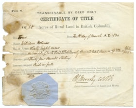
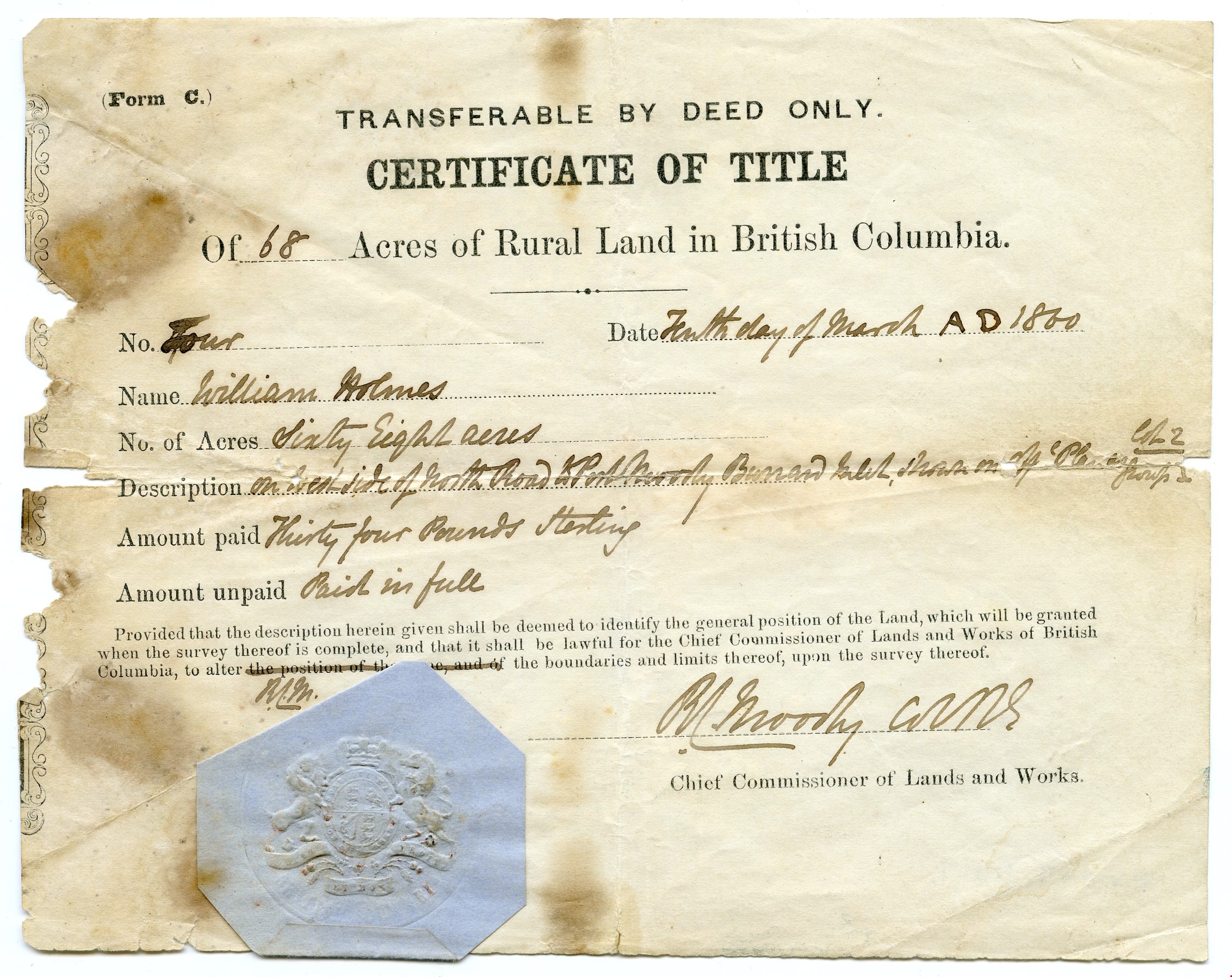
Certificate of Title
https://search.heritageburnaby.ca/link/museumdescription10409
- Repository
- Burnaby Village Museum
- Date
- 22 Mar. 1860
- Collection/Fonds
- William Holmes fonds
- Description Level
- Item
- Physical Description
- 1 certificate
- Scope and Content
- Item consists of "Certificate of Title" to Mr. William Holmes for land in Burnaby/NE Westminster; "68 Acres", "Tenth Day of March AD 1860". Description reads: "On West Side of North Road to Port Moody Burrard Inlet, shown on the [?] Plan as Lots 2 / Group 1". The blue Provincial seal is affixed to…
- Repository
- Burnaby Village Museum
- Collection/Fonds
- William Holmes fonds
- Description Level
- Item
- Physical Description
- 1 certificate
- Scope and Content
- Item consists of "Certificate of Title" to Mr. William Holmes for land in Burnaby/NE Westminster; "68 Acres", "Tenth Day of March AD 1860". Description reads: "On West Side of North Road to Port Moody Burrard Inlet, shown on the [?] Plan as Lots 2 / Group 1". The blue Provincial seal is affixed to the certificate and it is signed by R.C. Moody "Chief Commissioner of Lands and Works".
- Accession Code
- BV997.50.7
- Access Restriction
- No restrictions
- Reproduction Restriction
- No known restrictions
- Date
- 22 Mar. 1860
- Media Type
- Textual Record
- Scan Resolution
- 300
- Scan Date
- 06-May-2019
- Notes
- Title based on contents of item
Images
Elmer Wilson Martin fonds
https://search.heritageburnaby.ca/link/museumdescription10611
- Repository
- Burnaby Village Museum
- Date
- 1934-1973
- Collection/Fonds
- Elmer Wilson Martin fonds
- Description Level
- Fonds
- Physical Description
- 42 photographs + 9 architectural drawings + approx. 4 cm of textual records
- Scope and Content
- Fonds consists of photographs of E.W. Martin during his military service with the RCAF; development in Burnaby along Winch Street; Martin's Auto Villa on Hastings and Paneloc buildings together with E.W. Martin's military service records and other records relating to E.W. Martin's involvement with …
- Repository
- Burnaby Village Museum
- Collection/Fonds
- Elmer Wilson Martin fonds
- Description Level
- Fonds
- Physical Description
- 42 photographs + 9 architectural drawings + approx. 4 cm of textual records
- Scope and Content
- Fonds consists of photographs of E.W. Martin during his military service with the RCAF; development in Burnaby along Winch Street; Martin's Auto Villa on Hastings and Paneloc buildings together with E.W. Martin's military service records and other records relating to E.W. Martin's involvement with Paneloc Marketing Ltd. and other businesses. Fonds is arranged in the following series 1) E.W. Martin photographs series 2) E.W. Martin military records and photographs series 3) E.W. Martin business records series
- History
- Elmer Wilson Martin (1909-1973) was a professional engineer who lived most of his life in Burnaby. He was born in Treesbank Manitoba to William Henry Martin and Bethia “Bertie” Snell. Elmer married Ellen "Reta" Renetta Boyd (1908-1984) in approx. 1930. The couple moved to Burnaby in 1931 and Elmer graduated from UBC. Following his graduation from UBC, he spent two years at the University of Saskatchewan doing research. From 1936-1937 he worked at the Port Alice mill of the B.C. Pulp and paper Co and later worked for the Boeing aircraft plant at Vancouver. He joined the RCAF in September 1939, serving as chief engineering officer at various Canadian and overseas stations during WWII, until being discharged as a pilot and wing commander in November 1945. He served as NHA assistant regional engineer for a year after his discharge before becoming the owner and operator of Martin Auto Villa at 6574 East Hastings Street in North Burnaby. He was a director of the Burnaby Board of Trade from 1951 and chairman of the Burnaby Industrial Development Board and a member of the Professional Engineers' Association. He ran for Reeve under the Non-Partisan Association in Burnaby's municipal election in 1959 and donated land on Burnaby Mountain for Simon Fraser University. He had many businesses throughout his life including Paneloc Marketing Ltd. and his last one was as Director with the construction company Webb & Knapp Canada Ltd. The couple lived at various locations in Burnaby including, 6574 East Hastings Street eventually settling at 7231 Sutliff Street in North Burnaby in 1957. Elmer's brother, Wilbert Maurice Martin (1907-1980) was also born in Treesbank, Manitoba. Wilbert "Bert" was married to Eva (nee Erhart) Martin (1911-1993). Wilbert and Eva Martin lived on Winch Street in Burnaby. They first lived at 6776 Winch Street before relocating their house to 6656 Winch Street, Burnaby. Wilbert worked in construction as a building contractor and Eva worked as a hostess in the hotel industry. Paneloc buildings were developed by Elmer W. Martin, president of Paneloc Manufacturing Ltd. beginning in 1957 and were based on a design by A.B. Wenaus and Sons Ltd. In 1964, Martin held patents for his design of paneloc buildings in thirty six countries. Since Martin trained as a mechanical engineer, he developed a plan for his home model over a six year period in series of experiments with materials, styles, methods and sizes. Paneloc homes were prefabricated, using specially built bevelled wall panels cut-pie segments to form both the roof and the floor. The wall panels were designed to squeeze together by two metal straps on a turn-buckle basis. The roof and floor were held in place with factory-installed tap block bolts and a long wooden spine which fit in a keyway between the sections. The prefabricated parts were insulated and built with door and window allowances at Harrigan Industries Ltd. in Vancouver where Martin was part owner. Epoxy resin allowed the panels to be assembled without nails using weather-proofed five ply plywood. Sizes of homes varied using four by eight foot wall panels and increasing the span of the floor and roof sections. Harrigan Industries Ltd. continued to sell the prefabricated paneloc buildings until it went into receivership in late 1974.
- Creator
- Martin, Elmer Wilson
- Accession Code
- BV015.39
- BV019.37
- BV019.40
- Date
- 1934-1973
- Media Type
- Textual Record
- Photograph
- Architectural Drawing
- Arrangement
- The records are organized into three series based on the individual's business work as well as military and personal life. The photograhs series includes both professional and personal content.
- Notes
- Title based on contents of fonds
George and Wayne Kuyer with Valley Bakery staff
https://search.heritageburnaby.ca/link/museumdescription5820
- Repository
- Burnaby Village Museum
- Date
- [1960-1965]
- Collection/Fonds
- Burnaby Village Museum Photograph collection
- Description Level
- Item
- Physical Description
- 1 photograph : b&w ; copy scan
- Scope and Content
- Photograph of Valley Bakery owner George Kuyer, and son Wayne Kuyer (both in centre), surrounded by Valley Bakery staff in uniform. Long-serving employee Grace McMurcher standing at left.
- Repository
- Burnaby Village Museum
- Collection/Fonds
- Burnaby Village Museum Photograph collection
- Description Level
- Item
- Physical Description
- 1 photograph : b&w ; copy scan
- Scope and Content
- Photograph of Valley Bakery owner George Kuyer, and son Wayne Kuyer (both in centre), surrounded by Valley Bakery staff in uniform. Long-serving employee Grace McMurcher standing at left.
- History
- Valley Bakery was started in Burnaby in 1957 by Gerardus "George" Jacobus Kuyer. George started as an apprentice baker in Holland at age 13 and came from the Netherlands to Canada in 1954. He originally opened Valley Bakery at 4059 Hastings Street, near Gilmore Avenue. The bakery later moved to four other premises over the years, before opening at the present location at 4058 East Hastings Street. Valley Bakery brought European baking to the Burnaby area. Son Jack Kuyer bought the bakery from his father in 1979. Jack was an early adopter of using computers to track inventory in the bakery. As a strong community advocate, Jack was one of a few business owners that worked to halt a Department of Highways plan to rid Hastings Street of all street level parking. He was also integral in launching Hats Off Day, a festival designed for local merchants to show their appreciation for their customers. As of 2019, Hats Off Day is Burnaby's largest street festival. In 2015, the Burnaby Board of Trade inducted Valley Bakery into the Burnaby Business Excellence Awards Hall of Fame. The bakery has been in business for over 60 years as of 2019.
- Other Title Information
- title based on content of photograph
- Names
- Valley Bakery
- Kuyer, Jack
- Accession Code
- BV018.31.5
- Access Restriction
- Restricted access
- Reproduction Restriction
- May be restricted by third party rights
- Date
- [1960-1965]
- Media Type
- Photograph
- Scan Resolution
- 600
- Scan Date
- 27-Sep-2018
- Scale
- 96
Jesse Love farmhouse series
https://search.heritageburnaby.ca/link/museumdescription9782
- Repository
- Burnaby Village Museum
- Date
- [1893-1970] (date of originals), copied 1988-1998, predominant 1988-2000
- Collection/Fonds
- Burnaby Village Museum fonds
- Description Level
- Series
- Physical Description
- approx. 84 cm of textual records + approx. 1,910 photographs + approx. 100 architectural drawings + 3 audio cassettes + 1 videocassette
- Scope and Content
- Series consists of records involved in the purchase, moving, restoration, research, conservation and exhibiting of the Love family farmhouse by Burnaby Village Museum. Records have been arranged into the following subseries: 1) Love farmhouse conservation work files subseries 2) Love farmhouse re…
- Repository
- Burnaby Village Museum
- Collection/Fonds
- Burnaby Village Museum fonds
- Series
- Jesse Love farmhouse series
- Description Level
- Series
- Physical Description
- approx. 84 cm of textual records + approx. 1,910 photographs + approx. 100 architectural drawings + 3 audio cassettes + 1 videocassette
- Scope and Content
- Series consists of records involved in the purchase, moving, restoration, research, conservation and exhibiting of the Love family farmhouse by Burnaby Village Museum. Records have been arranged into the following subseries: 1) Love farmhouse conservation work files subseries 2) Love farmhouse restoration photographs subseries 3) Love farmhouse curatorial files subseries 4) Love farmouse research files subseries 5) Love family photographs 6) Love farmhouse Oral History subseries 7) Love farmhouse architectural drawings subseries
- History
- Jesse Love was born in Swindon, England in 1847 and left England to work on a dairy farm in the Toronto area. While working on the farm in Toronto, he met Martha Leonard who he married in 1879. Martha was born on February 3, 1858 in Bedfordshire, England and had come to Canada with her parents George and Ann Leonard. While living in Toronto, Jesse and Martha had two children, George born March 22, 1880 and Annie Elizabeth on August 24, 1881. About one year after Annie was born, the Love family moved to North Dakota to grow wheat. While living there, they had two more children, Henry who was born August 24, 1883 and Edith Minnie born October 9, 1885. The family decided to move further west after hearing about the fairer weather conditions from Martha’s father, George Leonard, who had settled in Vancouver in 1885. On May 23, 1887, Jesse, Martha and their four children arrived in Vancouver after travelling across Canada from Winnipeg on the first transcontinental train. The Loves made their home in Vancouver while Jesse helped clear land on Granville Street. Their fifth child, Thomas Robert was born on September 17, 1887 and soon after, the family moved to Lulu Island in Richmond where they lived growing vegetables and selling them to Vancouver hotels. While living and farming on Lulu island, the couple had two more girls, Martha (Dot or Dorothy) born on December 17, 1889 and Sarah Marie, born February 8, 1892. On October 6, 1893 an agreement was signed by Jesse Love to purchase 14.52 acres of land from Joseph C. Armstrong. The acreage covered the north east section of District Lot 25 within the newly incorporated District of the Municipality of Burnaby. It was here where the original Love house was built (between October 1893 and April 15, 1894) by Jesse Love with the help of local builder George Salt and father in law, George Leonard. The house consisted of an entrance hall, dining room, lean to kitchen, master bedroom and three bedrooms upstairs. A road was constructed and named Cumberland in 1905 and ran from District Lot 25 through to District Lot 11. The address for the Love home was 1390 Cumberland Road and in the early 1960’s the address was renumbered 7651 Cumberland Street. On the land surrounding the house, Jesse Love planted an orchard along with strawberries and raspberries which he sold at the Fraser Valley Market, T.S. Anandale’s Grocery Store in New Westminster and to hotels around Vancouver. Jesse Love served on the Burnaby School Board and also as a District Councillor in 1901 and from 1904-1907. While living in the house, Jesse and Martha had four more children, Phoebe Leonard, born April 15, 1894, Esther, born August 28, 1896, John Leonard, born June 7, 1899 and Hannah Victoria (also known as Girlie) who was born May 12, 1902. As the family grew to eleven children, additions along with some substantial remodelling in the craftsman style took place. In about 1898, a north wing addition was added to include a parlour with two windows, the construction of two more bedrooms and the relocation of the stair case to the North West wall. In 1903 the front door moved to the north elevation, a front porch was extended along the east wall and a summer lean to kitchen was added to the west elevation. Between 1905 and 1910, a tin embossed ceiling was installed along with an addition of the main kitchen which included a pantry, bathtub and a back porch. In about 1912, five craftsman style windows replaced the original pioneer tent style, the front verandah was enlarged to wrap around the south and east elevations, a back door was installed in the kitchen to access the verandah and wood shingle siding and brackets were added to the exterior. In 1918, at the age of 31 years, Robert Love fell ill due to an influenza epidemic and died on November 23, 1918. Following their son’s death, Martha Love became weak and on August 24, 1920, she passed away. By this time, Jesse had sold off a large percentage of his land and his youngest daughter, Girlie decided to stay on to live and care for him. Since the house was too large for just the two of them, Jesse invited any other children to return and share the residence. For a while his son, George and his wife joined them until 1925, followed by his daughter Sarah Parker (nee Love), her husband William and their three children, Albert, Bill and Elsie. The house remained pretty unchanged until 1928 after Jesse Love died of pneumonia (March 10, 1928) and the house was purchased by Sarah and her husband William Parker who continued to live there with their children. The master bedroom wall on the main floor opened up to the dining room, the kitchen pantry and bathtub converted to an alcove with a marble counter and enlarged window and sink while the bathroom was moved to the upstairs and the furnace and coolers were installed in the crawl space under the kitchen. A hot water tank was installed in the house in 1966. Sarah continued to live in the house until a little while after her husband William died in 1961. She sold the house to her daughter Elsie and husband John Hughes in 1966, who lived in the house along with their son Brent, until August 23, 1971. Mahbir Molchan Papan and his wife Geraldine Papan bought the house August 23, 1971 and by 1982, the house was sold to Nirmal Singh Singha and Narinder Singha. The Papans continued to rent the house from Nirmal Singh Singha and Narinder Singha until the late 1980s. In 1988, the house was scheduled for demolition with the remaining property to be subdivided. Fortunately, a neighbour, Mr. Harvey Elder recognized the farmhouse's historical significance and contacted the Burnaby Historical Society. Following this event, the owners agreed to donate the building to the Burnaby Village Museum (under the Century Park Museum Association) who financed the move of the house from Cumberland Street to the museum site. Heritage planner and architect, Robert Lemon provided guidance for the project. Prior to the move, the two porches were removed and demolished while the kitchen and roof were both separated from the main house. The kitchen and roof of the house were transported to Burnaby Village Museum on May 20, 1988 by Nickel Bros. House Moving company, while the main frame of the house completed its transportation to the museum near the end of May 1988 (due to low overhead wires). The house was moved down Cumberland Street to 10th Avenue, up Canada Way to Sperling and set on temporary footings near Hart House. Robert Lemon oversaw structural improvements such as, upgrading floor joists and creating new foundations to replace the original timber foundation of the farmhouse. The restoration went through several phases of work between 1988 until it opened in November 1998. Restoration began on both the interior and exterior features to be interpreted from the period of 1925. On November 23, 1992, the building was designated a heritage building under Heritage Designation Bylaw 1992, Bylaw Number 9807. In 1993, the architecture firm of Brian G. Hart Associates was appointed for the design and construction supervision of the restoration project. Plans were created for a foundation on the museum site in 1989 and the farmhouse was eventually settled on a permanent foundation behind the Burnaby Village Museum administration building in 1993 along with the reattachment of the roof. The kitchen section was reattached to the main house in 1994 along with skirting around the foundation and the reshingling of the exterior. In 1996, the tin ceiling was removed to make way for the installation of the internal electrical system along with sprinklers, ceiling heating and fire break gyprock. The dining room ceiling joists were consolidated, a pantry and bathroom were added to the kitchen, the downstairs bedroom wall was opened and filled, the dining and kitchen doorways were widened. In 1997, a wheelchair ramp was installed along with a concrete sidewalk, stair rails, cement pads at the base of the stairs and a gravel sink for any excess water. Interior work included painting of the kitchen, restoration and furnishing of the kitchen pantry, insulation of the house floor to protect from rodents along with the reconstruction of the kitchen and house chimneys. The registrar worked together with the curator and conservator and was tasked with a large research project on the house including the family contacts and family history, property information, plans, photographs, artifacts, furnishings, stories etc. all organized in files for easy retrieval. A great deal of research and conservation was undertaken in order to make the interior of the house authentic to the time period as possible. One of the biggest projects was selecting and obtaining wall coverings since much of the original wallpaper was incomplete and poor condition. The conservator and registrar were lucky enough to locate a few samples of the original paper and engage the Bradbury and Bradbury Art Wallpaper Company of Benica, California to reproduce replica designs for free. The City of Burnaby now has its own series “Burnaby Village Papers” produced by this company which are titled “Burnaby Wall”; “Burnaby Border” and “Burnaby Ceiling”. All three of these wallpaper designs have been used in the Love farm house and are also commercially available through the Bradbury and Bradbury Art Wallpaper Company. In 1997, restoration of the kitchen was completed and opened to the public. After the completion of the dining room, main floor bedroom and parlour, the Love farmhouse exhibit opened on November 29, 1998 with an open invitation to the public and extended members of the Love family. Officials including the Mayor, Doug Drummond and Love family members were all present to cut the ribbon for the special event.
- Accession Code
- BV018.41; BV020.5
- Access Restriction
- Restricted access
- Date
- [1893-1970] (date of originals), copied 1988-1998, predominant 1988-2000
- Arrangement
- The majority of the records within series and subseries were arranged by a staff members of Burnaby Village Museum who worked on the historical research and restoration of the house. Other photographs documenting the move and further restoration work were added later and included in the arrangment by format and subject.
- Notes
- Title based on content of series
- Jesse Love farmhouse is described as an Artifact under BV988.33.1
- Some records within this collection have restricted access and are subject to FIPPA
- Accessions BV018.41 and BV020.5 form this fonds
Letter re entry in Provincial Housing Plans Competition
https://search.heritageburnaby.ca/link/museumdescription15073
- Repository
- Burnaby Village Museum
- Date
- 13 Jun. 1968
- Collection/Fonds
- Elmer Wilson Martin fonds
- Description Level
- Item
- Physical Description
- 1 p.
- Scope and Content
- Item consists of a letter addressed to Mr. E.W. Martin from the Department of Municipal Affairs, Parliament Buildings, Victoria B.C. regarding his receipt of entry in the Provincial Housing Plans Competition.
- Repository
- Burnaby Village Museum
- Collection/Fonds
- Elmer Wilson Martin fonds
- Description Level
- Item
- Physical Description
- 1 p.
- Scope and Content
- Item consists of a letter addressed to Mr. E.W. Martin from the Department of Municipal Affairs, Parliament Buildings, Victoria B.C. regarding his receipt of entry in the Provincial Housing Plans Competition.
- Names
- Martin, Elmer Wilson
- Accession Code
- BV019.40.5
- Access Restriction
- No restrictions
- Reproduction Restriction
- May be restricted by third party rights
- Date
- 13 Jun. 1968
- Media Type
- Textual Record
- Scan Resolution
- 600
- Scan Date
- February 4, 2021
- Scale
- 100
- Notes
- Title based on contents of item
Images

Letter re entry in Provincial Housing Plans Competition
https://search.heritageburnaby.ca/link/museumdescription15074
- Repository
- Burnaby Village Museum
- Date
- 14 Aug. 1968
- Collection/Fonds
- Elmer Wilson Martin fonds
- Description Level
- File
- Physical Description
- 2 p.
- Scope and Content
- File consists of a letter and cheque stub addressed to Mr. E.W. Martin and J. Pearl from the Minister of Recreation and Conservation informing them of their award of one thousand dollars for their entry in the British Columbia Housing Plans Competition. Letter is signed by Ken Kiernan, Chairman of …
- Repository
- Burnaby Village Museum
- Collection/Fonds
- Elmer Wilson Martin fonds
- Description Level
- File
- Physical Description
- 2 p.
- Scope and Content
- File consists of a letter and cheque stub addressed to Mr. E.W. Martin and J. Pearl from the Minister of Recreation and Conservation informing them of their award of one thousand dollars for their entry in the British Columbia Housing Plans Competition. Letter is signed by Ken Kiernan, Chairman of the Competitiion Committee.
- Names
- Martin, Elmer Wilson
- Accession Code
- BV019.40.6
- Access Restriction
- No restrictions
- Reproduction Restriction
- May be restricted by third party rights
- Date
- 14 Aug. 1968
- Media Type
- Textual Record
- Scan Resolution
- 600
- Scan Date
- February 4, 2021
- Scale
- 100
- Notes
- Title based on contents of file

Property master designs for "X2: X-Men United"
https://search.heritageburnaby.ca/link/museumdescription19154
- Repository
- Burnaby Village Museum
- Date
- [2002]
- Collection/Fonds
- Hipman "Jimmy" Chow and Donna Polos fonds
- Description Level
- File
- Physical Description
- 1 portfolio : 15 photographs : col. prints + 12 col. laser prints
- Scope and Content
- File consists of a portfolio of prop concept design plans, prototypes and resource photographs for the Marvel film "X2: X-Men United". Concept designs were created by different designers and portfolio of collection was created by property master, Jimmy Chow. The portfolio was used as a communicatio…
- Repository
- Burnaby Village Museum
- Collection/Fonds
- Hipman "Jimmy" Chow and Donna Polos fonds
- Description Level
- File
- Physical Description
- 1 portfolio : 15 photographs : col. prints + 12 col. laser prints
- Scope and Content
- File consists of a portfolio of prop concept design plans, prototypes and resource photographs for the Marvel film "X2: X-Men United". Concept designs were created by different designers and portfolio of collection was created by property master, Jimmy Chow. The portfolio was used as a communication tool for sharing prototypes and plans with Jimmy's team who worked with him on the film. The film was directed by Bryan Singer and was released in 2003. Some of the concept designs within the portfolio were created by assistant art director, Brenton Harron, signed "Harron" and illustrator Dean Sherriff , signed "Sheriff".
- Accession Code
- BV022.21.107
- Access Restriction
- Restricted access
- Reproduction Restriction
- May be restricted by third party rights
- Date
- [2002]
- Media Type
- Photograph
- Graphic Material
- Scan Resolution
- 600
- Scan Date
- 2023-03-10
- Notes
- Title based on contents of file
- Title on spine of cover of portfolio reads: "X2 / PROPS"
- Chinese seal in red ink on spine of cover of portfolio identifying Jimmy Chow as the owner or creator
Images

Reverend Edward S. Gale fonds
https://search.heritageburnaby.ca/link/museumdescription18772
- Repository
- Burnaby Village Museum
- Date
- [1958-1990]
- Collection/Fonds
- Reverend Edward S. Gale fonds
- Description Level
- Fonds
- Physical Description
- 47 photographs + 2 architectural drawings
- Scope and Content
- Fonds consists of photographs and architectural landscape plans of the Mervin Mawhinney house and grounds on Burris Street collected and created by Reverend Edward S. Gale. The fonds includes photographs of the interior and exterior of the house documenting it's history and changes over time. Photo…
- Repository
- Burnaby Village Museum
- Collection/Fonds
- Reverend Edward S. Gale fonds
- Description Level
- Fonds
- Physical Description
- 47 photographs + 2 architectural drawings
- Scope and Content
- Fonds consists of photographs and architectural landscape plans of the Mervin Mawhinney house and grounds on Burris Street collected and created by Reverend Edward S. Gale. The fonds includes photographs of the interior and exterior of the house documenting it's history and changes over time. Photographs taken between 1962 and 1984 were taken by Michael Weller and photographs taken between 1984 and 1996 were likely taken by Reverend Gale. Fonds is arranged into series: 1) Mawhinney house photographs series 2) Mawhinney house landscape plans series
- History
- Reverend Edward S. Gale owned the Mervin Mawhinney house located at 7667 Burris Street in Burnaby and lived there between 1984 and 1996. Reverend E.S. Gale was an Anglican Church priest of the Saint Mary and Saint Martha of Bethany Church. Part of the Mawhinney house was converted and used a chapel for church gatherings while Reverend Gale owned it. In 1906 Isaiah Mawhinney purchased District Lot 86 and built a large house which he named “Evergreen”. In 1911, following the sudden death of his wife Annie Holmes Mawhinney, Isaiah sold the house and moved to New Westminster. In 1912, Isaiah’s son Mervin Mawhinney used his share of the sale to build a new house on Burris Avenue across the road from “Evergreen”. The house was occupied by Mervin and his wife Marjorie until some time after World War One when they moved to Vancouver. In 1958, the house was purchased by the “Order of St. Clare”, a Roman Catholic Franciscan order of nuns. During their time of ownership they closed in the front porch to create a four part entrance to protect their vows. In 1962, Michael and Jean Weller purchased the house and lived in it until 1984. The original house had its front entrance steps and porch facing Douglas Highway (now Canada Way). While living in the house, the Wellers completed a number of interior renovations including; the relocation of the front entrance from the north to the east side and the conversion of a sawdust furnace to gas. In 1983, Michael Weller subdivided the original 1.75 acre lot into two lots of .5 and .75 acres. Weller built a new house on the newly subdivided lot to the south of the original Mervin Mawhinney house. In 1984, the Mervin Mawhinney house was purchased by Reverend Edward S. Gale who continued to own it until 1996. The house was renamed “Pax House” which was part of the Saint Mary and Saint Martha of Bethany Church of the Anglican Catholic Church of Canada. While owning the house, Reverend Gale made several renovations to the house and re-landscaped the grounds. The original conservatory room inside of the house was converted to a chapel. Changes to the house were documented in the series of photographs taken by Michael Weller and Reverend Gale between 1962 and 1990. In 1960, the address of the house changed from 831 Burris Street to 7661 Burris Street. After the lot was subdivided in 1983, the address of the house was changed to 7667 Burris Street. Around 1996, Reverend Gale and the Wellers sold the property. The new owner later subdivided the westerly portion of the lot in conjunction with a two acre lot to the west, retaining the original Mervin Mawhinney house at 7667 Burris Street until 2018 when it was demolished and replaced. Reverend Edward S. Gale died sometime between 2015 and 2018.
- Accession Code
- BV018.9
- Date
- [1958-1990]
- Media Type
- Photograph
- Architectural Drawing
- Arrangement
- Photographs that were removed from mounting boards were described in the order in which they were obtained along with loose photographs. Arrangement of photographs that were removed boards was created by Reverend Gale.
- Notes
- Title based on contents of fonds
Seaforth School fonds
https://search.heritageburnaby.ca/link/museumdescription18824
- Repository
- Burnaby Village Museum
- Date
- 1922-1972
- Collection/Fonds
- Seaforth School fonds
- Description Level
- Fonds
- Physical Description
- 1 survey plan + 4 cm of textual records
- Scope and Content
- Fonds consists of records from Seaforth School in Burnaby including a Register of Pupils (1922-1924); a Visitors' Book (1922-1972) and a survey plan from 1957.
- Repository
- Burnaby Village Museum
- Collection/Fonds
- Seaforth School fonds
- Description Level
- Fonds
- Physical Description
- 1 survey plan + 4 cm of textual records
- Scope and Content
- Fonds consists of records from Seaforth School in Burnaby including a Register of Pupils (1922-1924); a Visitors' Book (1922-1972) and a survey plan from 1957.
- History
- Seaforth school was built in 1922 in District Lot 42 on the corner of Piper and Goverment Streets in Burnaby. The school was named after its sponsor, the Seaforth Chapter of the Imperial Order of Daughters of the Empire. Bowman and Cullerne, the architects for the Burnaby School Board, designed the one room schoolhouse which was constructed by local contractor, Alphonse J. Toebaert. The school was moved to Burnaby Village Museum in 1983, and was opened to the public after extensive restoration in 1987.
- Creator
- Seaforth School
- Names
- Seaforth School
- Accession Code
- BV987.2
- Date
- 1922-1972
- Media Type
- Cartographic Material
- Textual Record
- Notes
- Title based on contents of fonds
Valley Bakery from Hastings Street
https://search.heritageburnaby.ca/link/museumdescription5817
- Repository
- Burnaby Village Museum
- Date
- [1960-1969]
- Collection/Fonds
- Burnaby Village Museum Photograph collection
- Description Level
- Item
- Physical Description
- 1 photograph : b&w ; copy scan
- Scope and Content
- Photograph of Valley Bakery at Adele-Rae Florists' former location on Hastings Street. A car is parked out front of store on left of photograph.
- Repository
- Burnaby Village Museum
- Collection/Fonds
- Burnaby Village Museum Photograph collection
- Description Level
- Item
- Physical Description
- 1 photograph : b&w ; copy scan
- Scope and Content
- Photograph of Valley Bakery at Adele-Rae Florists' former location on Hastings Street. A car is parked out front of store on left of photograph.
- History
- Valley Bakery was started in Burnaby in 1957 by Gerardus "George" Jacobus Kuyer. George started as an apprentice baker in Holland at age 13 and came from the Netherlands to Canada in 1954. He originally opened Valley Bakery at 4059 Hastings Street, near Gilmore Avenue. The bakery later moved to four other premises over the years, before opening at the present location at 4058 East Hastings Street. Valley Bakery brought European baking to the Burnaby area. Son Jack Kuyer bought the bakery from his father in 1979. Jack was an early adopter of using computers to track inventory in the bakery. As a strong community advocate, Jack was one of a few business owners that worked to halt a Department of Highways plan to rid Hastings Street of all street level parking. He was also integral in launching Hats Off Day, a festival designed for local merchants to show their appreciation for their customers. As of 2019, Hats Off Day is Burnaby's largest street festival. In 2015, the Burnaby Board of Trade inducted Valley Bakery into the Burnaby Business Excellence Awards Hall of Fame. The bakery has been in business for over 60 years as of 2019.
- Other Title Information
- title based on content of photograph
- Names
- Valley Bakery
- Kuyer, Jack
- Accession Code
- BV018.31.2
- Access Restriction
- Restricted access
- Reproduction Restriction
- May be restricted by third party rights
- Date
- [1960-1969]
- Media Type
- Photograph
- Scan Resolution
- 600
- Scan Date
- 27-Sep-2018
- Scale
- 96
Burnaby Girl Guides fonds
https://search.heritageburnaby.ca/link/museumdescription4614
- Repository
- Burnaby Village Museum
- Date
- 1914-2009
- Collection/Fonds
- Burnaby Girl Guides fonds
- Description Level
- Fonds
- Physical Description
- 22 scrapbooks : photographs + textual records + illustrations + digital files : col. (pdfs) + photographs : col. (tiffs) + col. (jpegs) + 222 photographs : b&w ; col. + 12 cm of textual records + ephemera
- Scope and Content
- Fonds consists of a collection of scrapbooks containing photographs, textual records, illustrations and ephemera along with individual photographs and textual records related to Burnaby Girl Guides. Records document the activities and functions of Burnaby Girl Guides through histories, journals, ne…
- Repository
- Burnaby Village Museum
- Collection/Fonds
- Burnaby Girl Guides fonds
- Description Level
- Fonds
- Physical Description
- 22 scrapbooks : photographs + textual records + illustrations + digital files : col. (pdfs) + photographs : col. (tiffs) + col. (jpegs) + 222 photographs : b&w ; col. + 12 cm of textual records + ephemera
- Scope and Content
- Fonds consists of a collection of scrapbooks containing photographs, textual records, illustrations and ephemera along with individual photographs and textual records related to Burnaby Girl Guides. Records document the activities and functions of Burnaby Girl Guides through histories, journals, newspaper clippings, certificates, awards, programmes, photographs, illustrations and newsletters. Scrapbooks were created by Burnaby Girl Guides and Girl Guide leaders and deposited with the Burnaby Girl Guide Archivist prior to being donated to the Burnaby Village Museum. Record descriptions are available at both item and file level. Fonds is arranged into the following series: 1) Burnaby Girl Guides scrapbooks and photographs series 2) Burnaby Girl Guides administrative records and histories series 3) Burnaby Girl Guides newsletters series 4) Burnaby Girl Guides memorabilia series
- History
- The Girl Guide Movement began in England in 1909 when girls in England demanded to take part in a Boy Scouts rally at the Crystal Palace in London, organized by Chief Scout and Boy Scout founder Lord Robert Baden-Powell. Following this event, Baden Powell asked his sister, Agnes Baden-Powell to help him start a similar organization for girls and Girl Guides was formed. Girl Guides came to Canada in 1910 and the first troop in British Columbia was registered in Victoria in 1912. In 1913 Amy Leigh moved to Burnaby from England and enquired about a Guiding company in her area and was disappointed to find none. On June 11, 1914 at the age of 17 years, Amy registered the 1st Burnaby Girl Guide Company and became the captain. On April 2, 1916 the 2nd Burnaby Guide Company registered and met at Edmonds School. In this same year, the very first Burnaby Girl Guide Rally event took place at Central Park and by 1920 another took place at the Burnaby Municipal Hall (Edmonds) and was attended by both Burnaby and New Westminster Guides. The First Burnaby Brownie Pack was registered on December 1922 with Mrs. W.J. Matherson as Brown Owl. The Brownie Pack met in a West Burnaby facility. The First Burnaby Land Ranger Co. was formed on November 29, 1923 and by 1924 Burnaby became a District with four Guide companies, four Brownie Packs and the Rangers. In 1923 records show Mrs. Gavin as commissioner, Mrs. C.F. Carter in 1924 and Miss Amy Leigh between 1926 and 1928. The first District camp was held near Sechelt in 1927 on the property of Mrs. Deal and Mrs. Nixon with annual camps held here until 1930 when the Guide camp at Wilson Creek was established. In 1929 Guides and Brownies began taking part in the Annual May Day Celebrations at Central Park. In 1930 Burnaby became a Division with Mrs. C.F. Carter as Division Commissioner and Mrs. G. Peel as District Commissioner for South Burnaby and in 1931 Miss Amy Leigh became the first North Burnaby Commissioner. The 5th Burnaby Girl Guide Company in North Burnaby began publishing a bulletin in 1935. In this same year Burnaby Girl Guides attended a rally for Lord and Lady Powell who were visiting Vancouver and Burnaby Girl Guides became affiliated with Greater Vancouver Girl Guide Council. The packs and companies of North Burnaby were attached to the eastern section of Vancouver while South Burnaby and South Vancouver District became another Division. Mrs. Pochin organized the Burnaby Lake District in 1943 becoming the first District commissioner (In 1927 Mrs. Peel had guides in this area). The first training classes for Girl Guides were held in 1943 in a hall on Buller Avenue at the BCER tracks and also Phillips Hall on McKay Avenue. By 1945 a training camp was held on Mrs. Pochin’s property on Deer Lake. South Vancouver, South Burnaby and Burnaby Lake Districts took part in the training which was a change over from war time service and the return of Pioneer camping. Miss E. Perition was in charge of camp which was attended by Mrs. J. Quinnell, Mrs. J. Albertson and many guiders. In 1946 Lady Baden Powel returned for a visit to Vancouver and there was a rally at Connaught Park and Chief Scout Lord Rowallyn held a rally at Brocton Point. In 1947 Mrs. J. Albertson became Division Commissioner for South Vancouver and South Burnaby. Districts of Burnaby Lake and South Burnaby each adopted a European child and undertook to send regular parcels and by 1948 these Districts became a Burnaby Division once more under Division Commissioner Mrs. W.M. Wall. In September 1949 the first Sea Ranger Crew “S.R.S. Royal Oak” was formed under the Skipper, Miss E. Periton. The S.R.S. Royal Oak met at All Saint’s Church Hall on Royal Oak Ave. In 1950 Packs and Companies in North Burnaby organized into a District under Mrs. Hebron and in 1953 Sperling District was organized by District Commissioner Mrs. Hancock. 1953 was also the same year that South Burnaby District was divided into three Districts: Central Park District under Commissioner Miss Perition, Douglas District under Commissioner Mrs. J. McKee Wilson and Kingsway under Commissioner Mrs. J.G. Fowler. A few years later, in 1955 the guides and brownies were out in force to welcome Lady Baden Powel at a rally held in the PNE Gardens building and by March 1956 Burnaby ceased to be a part of Greater Vancouver Area and was organized under two Divisions of the Province. The Sperling, Willingdon and Vancouver Heights Districts in North Burnaby became North Burnaby Division with Mrs. H. Hebron as Division Commissioner. With rapid population growth further decentralization became necessary and South Burnaby Division was split in two, adding the new division of Central Burnaby under Commissioner Miss E. Perition. Central Burnaby was composed of three Districts: Burnaby Lake, Central Park and a new District named “Windsor” under Mrs. C. Dumfries. South Burnaby was composed of three Districts: Kingsway, Edmonds and Lakeview (the latter two also referred to as Douglas with Mrs. McGeachie and Mrs. J. Park as the first commissioners of these two Districts). In 1957 Burnaby became an Area unto itself with three Divisions, and 9 Districts under Miss Periton as the first Area Commissioner. In February 1957, Burnaby entered into a contract with Vancouver Girl Guide Council to lease a part of the Wilson Creek campsite. Under the leadership of Area Commissioner, Miss Periton, work started on the development of the site with funds raised by both the Girl Guides, local citizens and associations. A camp committee was formed with representation from each Division and a lot of help from Miss Norah Weller, the Wilson Creek camp manager. Plans were laid for the site with a dining shelter, store room and cook stove contracted for while a subcommittee of men was appointed to purchase building supplies and organize work parties to build cabins, a staff house, water pipes and sanitary facilities. The site opened in May 1958 with $6000 expended on building and equipping the camp, while an official opening took place on June 8 and by July Girl Guides began camping on the site. The Burnaby Area Committee became a member of the Burnaby Community Council and a participant in Community Chest in 1958 and on May 1, the Burnaby Area office opened. By 1959, with further participation in North Burnaby, Sperling District was split to form Sperling and Hillview Districts and by 1960 Kingsway District of South Burnaby split to form Kingsway and Royal Oak Districts. By December 1960, Burnaby Area had 3 Divisions, 11 Districts with a total membership of 2, 331.
- Creator
- Girl Guides of Canada
- Accession Code
- BV015.35
- BV015.36
- BV016.49
- Access Restriction
- No restrictions
- Reproduction Restriction
- May be restricted by third party rights
- Date
- 1914-2009
- Media Type
- Textual Record
- Photograph
- Notes
- Title based on contents of fonds
- Some scrapbooks are only available in digital formats
- Accessions that form part of this fonds include: BV015.35; BV015.36; BV016.49
Gerald F. Sanders and Alice Sparman Sanders fonds
https://search.heritageburnaby.ca/link/museumdescription18831
- Repository
- Burnaby Village Museum
- Date
- 1918-2016
- Collection/Fonds
- Gerald F. Sanders and Alice Sparman Sanders fonds
- Description Level
- Fonds
- Physical Description
- 33 photographs + 7 architectural drawings +1 cm of textual records
- Scope and Content
- Fonds consists of family photographs and personal papers pertaining to Gerald Frank Sanders and Alice Viola Sparman Sanders along with architectural plans pertaining to the family home located on Spruce Street in Burnaby. Fonds has been arranged into the following series: 1) Sanders-Sparman photog…
- Repository
- Burnaby Village Museum
- Collection/Fonds
- Gerald F. Sanders and Alice Sparman Sanders fonds
- Description Level
- Fonds
- Physical Description
- 33 photographs + 7 architectural drawings +1 cm of textual records
- Scope and Content
- Fonds consists of family photographs and personal papers pertaining to Gerald Frank Sanders and Alice Viola Sparman Sanders along with architectural plans pertaining to the family home located on Spruce Street in Burnaby. Fonds has been arranged into the following series: 1) Sanders-Sparman photographs series 2) Sanders family personal papers 3) Sanders family architectural drawings
- History
- Gerald Frank Sanders (1916-2017) was born August 28, 1916 in Hackney, London. In 1918, Gerald immigrated to Canada with his mother Harriett Sanders (nee Chalkley) (1889-1962) while his father, Frank (1887-1967) was convalescing in hospital in England after succumbing to wounds while serving in action during WWI. Gerald's father, Frank soon joined them in British Columbia. In 1926 they settled in a house located at 4312 Spruce Street near the corner of Spruce Street and Carleton Avenue. By 1946 the family grew in size to four children (Gerald, Leslie, Reginald and Eileen) and they built a larger house right on the corner of Spruce and Carleton Avenue. Gerald attended Inman Elementary, then Van Technical School. He eventually joined the RAF during WWII as an airplane mechanic in England. He sent his pay home and his mother purchased two lots on Pine Street with some of the money. On March 8, 1948 Gerald married Alice Viola Sparman (1925-1996) and the couple lived in the Sanders' family home on Spruce Street. Alice grew up near Cranbrook and spent her teenage years in Victoria. She trained to be a nurse at St. Paul’s Hospital in Vancouver before marrying Gerald. Alice worked at the Burnaby General Hospital from 1952. Gerald and Alice had six children: Dennis, Kris, Kerry, David, Ruth and Marie. In 1949 with the help of family and friends Gerald built a new house located at 4325 Pine Street (address after 1959- 4091 Pine Street) and he moved in with his family. Gerald worked as a carpenter on various projects including the dentistry building at University of British Columbia, the Vancouver Court House and Jack Poole's house in the British Properties. Gerald lived in Burnaby until his death in 2017. Frank and Harriett Sanders lived on Spruce Street until Harriett died in 1962. Frank continued to live on Spruce Street until 1964 and then lived with his son Gerald on Pine Street until his death in 1967.
- Accession Code
- BV018.34
- Date
- 1918-2016
- Media Type
- Photograph
- Architectural Drawing
- Textual Record
- Arrangement
- Records and series were arranged by specific record types.
- Notes
- Title based on contents of fonds