Narrow Results By
Creator
- Bodnar, Diana, 1950- 1
- Century Park Museum Association 1
- Chalmers, Graeme, 1943- 1
- Corsbie, Joseph Hardcastle-Cumberland "Joe" 1
- Fuller, G. A. (George A.), 1927- 1
- Griffin, J. A. (John A.), 1922- 1
- Hill, Albert James 1
- Jokinen, Eric P. 1
- Molson, K. M. (Kenneth M.) 1
- Moorcroft, Frances, 1944- 1
- Nylander, Jane C., 1938- 1
- Sone, Michael 1

Fabrics for historic buildings
https://search.heritageburnaby.ca/link/museumlibrary1054
- Repository
- Burnaby Village Museum
- Author
- Nylander, Jane C., 1938-
- Edition
- 2nd ed.
- Publication Date
- c1980
- Call Number
- 747.5 NYL
- Repository
- Burnaby Village Museum
- Collection
- Reference Collection
- Material Type
- Book
- ISBN
- 089133081X
- 9780891330813
- Call Number
- 747.5 NYL
- Edition
- 2nd ed.
- Author
- Nylander, Jane C., 1938-
- Place of Publication
- Washington, D.C.
- Publisher
- Preservation Press
- Publication Date
- c1980
- Physical Description
- 58 p. : ill. ; 27 cm.
- Library Subject (LOC)
- Textile fabrics--Reproduction
- Historic buildings--Conservation and restoration
- Notes
- Includes bibliographical references (p. 57-58).
Burnaby heritage resource inventory : Metrotown (including the historic communities of Central Park, Patterson, McKay, West Burnaby, Jubilee, Royal Oak)
https://search.heritageburnaby.ca/link/museumlibrary1117
- Repository
- Burnaby Village Museum
- Collection
- Reference Collection
- Material Type
- Book
- Call Number
- 971.1 BUR
- Author
- Watson, Ann A.
- Place of Publication
- [Burnaby, B.C.]
- Publisher
- Burnaby Historical Society
- Publication Date
- 1986
- Physical Description
- v, 144 p. : ill. ; 22 x 29 cm.
- Library Subject (LOC)
- Historic buildings--British Columbia--Burnaby
- Buildings--British Columbia--Burnaby
- Burnaby (B.C.)--Buildings, structures, etc.
- Metrotown (Burnaby, B.C.)
- Directories
- Notes
- "August 1986"--Cover.
- Includes bibliographical references (p. 122-125) and index.

British Columbia houses : guide to the styles of domestic architecture in British Columbia
https://search.heritageburnaby.ca/link/museumlibrary997
- Repository
- Burnaby Village Museum
- Collection
- Reference Collection
- Material Type
- Book
- ISBN
- 0888650167
- 9780888650160
- Call Number
- 728.09 CHA
- Place of Publication
- [Vancouver]
- Publisher
- Western Education Development Group, Centre for the Study of Curriculum and Instruction, University of British Columbia
- Publication Date
- 1981
- Physical Description
- ix, 214 p. : ill. ; 22 x 28 cm.
- Library Subject (LOC)
- Architecture
- Dwellings
- Subjects
- Buildings
- Buildings - Heritage
- Notes
- Subtitle on cover: A workbook for secondary art & home economics students.
- Includes bibliographical references (p. 202-204).
City of Vancouver heritage inventory of Vancouver schools : report
https://search.heritageburnaby.ca/link/museumlibrary1000
- Repository
- Burnaby Village Museum
- Author
- Bodnar, Diana, 1950-
- Publication Date
- 1982
- Call Number
- 727. BOD
- Repository
- Burnaby Village Museum
- Collection
- Reference Collection
- Material Type
- Book
- Call Number
- 727. BOD
- Author
- Bodnar, Diana, 1950-
- Place of Publication
- [Vancouver, B.C]
- Publisher
- City of Vancouver
- Publication Date
- 1982
- Physical Description
- 60 leaves : ill. ; 28 cm.
- Library Subject (LOC)
- Architecture
- Subjects
- Buildings - Heritage
- Buildings - Schools
- Geographic Access
- Vancouver
- Notes
- Includes bibliographical references (p. 58-60).
- Prepared for the Vancouver Heritage Advisory Committee.

Pioneer tales of Burnaby
https://search.heritageburnaby.ca/link/museumlibrary5860
- Repository
- Burnaby Village Museum
- Collection
- Digital Reference Collection
- Reference Collection
- Material Type
- Book
- ISBN
- 096928280x
- Call Number
- 971.133 SON COPY 4
- Contributor
- Sone, Michael
- Place of Publication
- Burnaby, B.C.
- Publisher
- Corporation of the District of Burnaby
- Publication Date
- c1987
- Physical Description
- 495 p. : ill. ; 31 cm.
- Inscription
- "TR687 - Bryburgh" / handprinted in pencil on frontend page
- Library Subject (LOC)
- Pioneers--British Columbia--Burnaby
- Frontier and pioneer life
- Biography
- Object History
- Early Burnaby as recalled by the settlers themselves who arrived from every corner of the world between 1888 and 1930, some witnessing incorporation of the district in 1892, all seeking a better life for themselves and especially for their children, all helping transform the wilderness into the modern municipality of today.
- Notes
- "Editor Michael Sone".
- Includes index.
- 4 copies held: copy 4
Images

Digital Books
Century Park Museum Association fonds
https://search.heritageburnaby.ca/link/museumdescription3781
- Repository
- Burnaby Village Museum
- Date
- 1971-1989
- Collection/Fonds
- Century Park Museum Association fonds
- Description Level
- Fonds
- Physical Description
- 1814 photographs + 219 architectural drawings + 17 technical drawings + 4 videocassettes + 3 audio reels + 17 audio cassettes + 1.6 m of textual records + 2 maps
- Scope and Content
- Fonds consists of records created and collected by the Century Park Museum Association (renamed Burnaby Village Museum Association after 1984), which managed Heritage Village (later named Burnaby Village Museum) from its opening in 1971 until it's dissolution in December 1989. Records include archi…
- Repository
- Burnaby Village Museum
- Collection/Fonds
- Century Park Museum Association fonds
- Description Level
- Fonds
- Physical Description
- 1814 photographs + 219 architectural drawings + 17 technical drawings + 4 videocassettes + 3 audio reels + 17 audio cassettes + 1.6 m of textual records + 2 maps
- Scope and Content
- Fonds consists of records created and collected by the Century Park Museum Association (renamed Burnaby Village Museum Association after 1984), which managed Heritage Village (later named Burnaby Village Museum) from its opening in 1971 until it's dissolution in December 1989. Records include architectural drawings and proposals; photographs and films of the site; documentation of exhibits and artifacts, special events and programs; oral history interviews and other sound recordings; association meeting minutes; constitutions and bylaws; financial records; reports; correspondence; publications and research materials. Fonds has been arranged into the following series: 1) Century Park Museum Association photograph collection series 2) Century Park Museum Association film collection series 3) Century Park Museum Association architectural records and reports series 4) Heritage Village Museum oral history Interviews series 5) Heritage Village Museum presentations and Programming series 6) Century Park Museum Association reports series 7) Century Park Museum Association constitution, bylaws and agreements series 8) Century Park Museum Association minutes of meetings series 9) Century Park Museum association Board of Directors' administrative files series 10) Century Park Museum membership series 11) Heritage Village Museum exhibits and artifacts series 12) Century Park Museum Association committees' minutes and reports series 13) Museum staff adminstrative files series 14) Century Park Museum Association financial records series
- History
- The Heritage Village Museum was originally created as a British Columbia Centennial Project in 1971 through funding from the Federal, Provincial and Municipal governments. A sub-committee of the Burnaby Centennial '71 Committee was responsible for the creation of a permanent commemorative project. The concept for an open-air museum was developed with the location to be in Burnaby on lots 8,9, 10 and 11 of District Lot 79 and Lots 2 and 5, Block "R" of Districts Lots 79 and 85. The official sod turning for Heritage Village took place on April 11, 1971. In the spring of 1971, a museum director and curator were hired to oversee the development of the project and the acquisition of artifacts with funding from the Parks and Recreation Commission. The Century Park Museum Association (CPMA) was founded under the auspices of the Burnaby Centennial '71 Committee to govern Burnaby's Centennial '71 Commemorative Project, Heritage Village. The CPMA Board of directors were elected on October 26, 1971 with Donald (Don) Copan as the founding president (Don continued to serve on the Board until 1989). The Board of Directors reported directly to the Municipal Council. The association had an overall objective of providing a museum that was a historical resource for Burnaby and the region. The museum mandate was to collect, preserve, research, document and interpret artifacts and historical buildings that illustrated the history and lifestyle of the Lower Mainland in B.C. and Burnaby. The Museum focused on the period between 1890 and 1925 depicting a village lifestyle of a small community. This was achieved through the use of exhibits and displays within historic buildings and built reconstructions along with costumed museum interpreters. Many people contributed to the construction and design of the village. Architect, Rudy Kovach created the initial concept drawings and architecture designs were created by architectural design consultants Hopping, Kovach and Grinnell. Many carpenters and tradespeople worked on the construction of the buildings including Mr. Angelo Giacometti who was respsonible for much of the final decorative elements. The official opening of Heritage Village took place on November 19, 1971 with Burnaby Mayor Bob Prittie and Canada’s Governor General Roland Michener. Heritage Village was opened up to the public for a few days between November 19 and 21 with approximately 15,000 visitors. On July 1st, 1972 Heritage Village re-opened for the summer season with CPMA president, Don Copan and Mayor Bob Prittie officiating. This opening showcased further development of the site with more buildings and exhibits added. In 1984, Heritage Village Museum changed its name to “Burnaby Village Museum” and in turn, the Century Park Museum Association changed its name to the “Burnaby Village Museum Association”. Burnaby Village Museum continued to be governed by the Burnaby Village Museum Association until the end of 1989. In 1990, the Corporation of the District of Burnaby assumed the operation and management of Burnaby Village Museum under the Parks, Recreation and Cultural Services Department and the Burnaby Village Museum Association was dissolved.
- Responsibility
- Century Park Museum Association
- Accession Code
- BV985.6028
- BV005.14
- BV000.18
- BV011.44
- BV011.50
- BV014.30
- BV016.56
- BV017.46
- BV018.21
- BV019.52
- BV020.4
- BV020.5
- BV021.5
- BV022.9
- Date
- 1971-1989
- Media Type
- Photograph
- Sound Recording
- Textual Record
- Architectural Drawing
- Moving Images
- Cartographic Material
- Technical Drawing
- Related Material
- Donald Copan fonds
- Burnaby Centennial '71 Committee collection
- Royal Bank exhibit collection
- Bell's Dry Goods exhibit collection
- Jesse Love farmhouse fonds
- Burnaby Village Museum fonds
- Arrangement
- Records are arranged by types and functions of the Century Park Museum Association. The series reflects how they were maintained by the associaton, it's members and staff of Heritage Village (Burnaby Village Museum) while under the governance of the association.
- Notes
- Title based on contents of fonds
- Further accruals are expected
- Some records within this fonds are Closed - contact Burnaby Village Museum for access

Canadian heritage preservation
https://search.heritageburnaby.ca/link/museumlibrary988
- Repository
- Burnaby Village Museum
- Author
- Jokinen, Eric P.
- Publication Date
- c1987
- Call Number
- 720.28 JOK
- Repository
- Burnaby Village Museum
- Collection
- Reference Collection
- Material Type
- Book
- ISBN
- 0919433367
- 0919433405
- Call Number
- 720.28 JOK
- Author
- Jokinen, Eric P.
- Place of Publication
- Edmonton
- Publisher
- Lone Pine
- Publication Date
- c1987
- Physical Description
- 158 p. : ill. ; 29 cm.
- Inscription
- "Susan Green", handwritten in pencil on cover page.
- Library Subject (LOC)
- Historic buildings--Conservation and restoration--Canada
- Notes
- Includes bibliographical references (p. 156) and index.
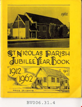
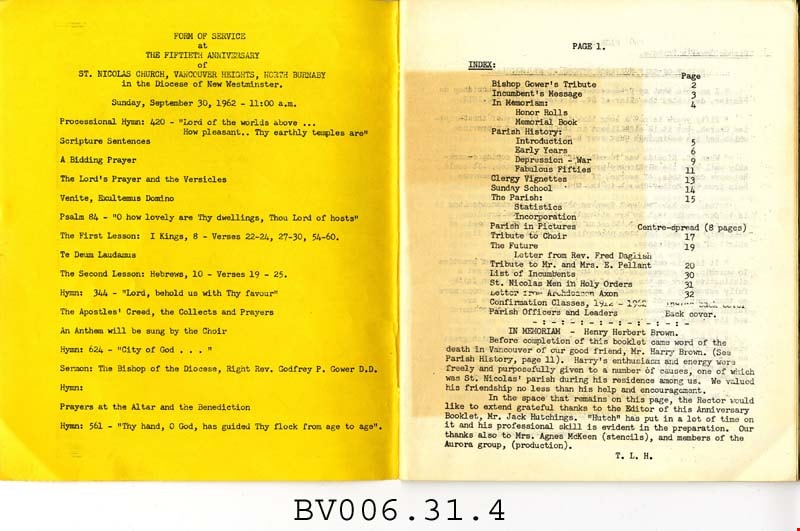
St. Nicolas Parish jubilee year book 1912-1962
https://search.heritageburnaby.ca/link/museumlibrary5013
- Repository
- Burnaby Village Museum
- Author
- St. Nicolas Parish
- Publication Date
- 1962
- Call Number
- 377 STN
- Repository
- Burnaby Village Museum
- Collection
- Special Collection
- Material Type
- Book
- Accession Code
- BV006.31.4
- Call Number
- 377 STN
- Author
- St. Nicolas Parish
- Place of Publication
- Burnaby
- Publisher
- St. Nicolas Parish
- Publication Date
- 1962
- Physical Description
- 32 p. : 22 cm.
- Library Subject (LOC)
- Church buildings
- Church anniversaries
- Subjects
- Documentary Artifacts - Books
- Historic Neighbourhood
- Vancouver Heights (Historic Neighbourhood)
- Geographic Access
- Triumph Street
- Street Address
- 3883 Triumph Street
- Notes
- Includes index.
Images


Heritage Village Museum exhibits and artifacts series
https://search.heritageburnaby.ca/link/museumdescription14281
- Repository
- Burnaby Village Museum
- Date
- 1971-1989
- Collection/Fonds
- Century Park Museum Association fonds
- Description Level
- Series
- Physical Description
- 707 photographs + 1 audio reel + 3 audio cassettes + 2 maps
- Scope and Content
- Series consists of records documenting Heritage Village (1971-1983) and Burnaby Village Museum (1984-1989) exhibits and artifacts while it was under the governance and administration of the Century Park Museum Association (Burnaby Village Museum Association) between November 1971 and December 1989.…
- Repository
- Burnaby Village Museum
- Collection/Fonds
- Century Park Museum Association fonds
- Description Level
- Series
- Physical Description
- 707 photographs + 1 audio reel + 3 audio cassettes + 2 maps
- Scope and Content
- Series consists of records documenting Heritage Village (1971-1983) and Burnaby Village Museum (1984-1989) exhibits and artifacts while it was under the governance and administration of the Century Park Museum Association (Burnaby Village Museum Association) between November 1971 and December 1989. Series includes photographs and textual records pertaining to exhibits and artifacts including buildings that form part of the museum's collection along with interpretive maps, audio recordings of samplings from the collection and registers from the Village Church.
- Accession Code
- BV985.6028
- BV005.14
- BV016.56
- BV017.46
- BV020.4
- BV020.5
- BV021.5
- Date
- 1971-1989
- Media Type
- Photograph
- Sound Recording
- Cartographic Material
- Related Material
- See also Don Copan fonds; Burnaby Centennial '71 Committee collection
- Arrangement
- Item level descriptions available
- Notes
- Title based on contents of series
- Further accruals are expected
Joseph H.C. Corsbie fonds
https://search.heritageburnaby.ca/link/museumdescription20275
- Repository
- Burnaby Village Museum
- Date
- [1941-1988]
- Collection/Fonds
- Joseph H.C. Corsbie fonds
- Description Level
- Fonds
- Physical Description
- 35 photographs + 1.5 cm textual records + 1 map + 1 book
- Scope and Content
- Fonds consists of photographs and documents relating to Joseph (Joe) Hardcastle Cumberland Corsbie during his service with the RCAF during World War II (1942-1945) along with photographs and docments relating to his personal and professional life (. Fonds is arranged into series: 1) Joseph H.C. Co…
- Repository
- Burnaby Village Museum
- Collection/Fonds
- Joseph H.C. Corsbie fonds
- Description Level
- Fonds
- Physical Description
- 35 photographs + 1.5 cm textual records + 1 map + 1 book
- Scope and Content
- Fonds consists of photographs and documents relating to Joseph (Joe) Hardcastle Cumberland Corsbie during his service with the RCAF during World War II (1942-1945) along with photographs and docments relating to his personal and professional life (. Fonds is arranged into series: 1) Joseph H.C. Corsbie RCAF records series 2) Joseph H.C. Corsbie personal and professional records series
- History
- Joseph “Joe” Hardcastle Cumberland Corsbie was born in 1913 in Peace River (Doe River) to parents Joseph Hardcastle Cumberland Corsbie and Winnifred Ann Mapleton Corsbie. As an adult Joe trained and served with the Royal Canadian Air Force as a navigator between 1942 and 1945. In 1945, while serving with the RCAF during World War II, Joe was awarded the Distinguished Flying Cross. After World War II, Joe returned to Peace River where he was elected as a Member of the Legislative Assembly serving as a Co-operative Commonwealth Federation MLA for one term between 1945 and 1948. In April 1948, Joe Corsbie married Margaret Carr in the Metropolitan United Church in Victoria followed by a reception held at the B.C. Legislature buildings. On their wedding day, the couple were honoured with a hand painted congratulatory certificate signed by members of the B.C. Legislature. In late, 1948, Joe lost the election and moved with his wife Margaret to Black Creek, B.C. to manage a co-op store. In 1949, the couple welcome their first child who they named Margaret after her mother. In 1950, Joe, Margaret and their daughter moved to a home on Charles Street in Burnaby and Joe began working as the General Manager of the Gulf and Fraser Fishermen’s Credit Union. In 1951, Joe and Margaret welcomed their second child, named Josesph after his father and in 1952, Joe, Margaret and family moved to 84 Springer Avenue, Burnaby where they lived until 1989. Between 1959 and 1976, Joe worked as a General Manager for the CU & C Health Services Society (later became Pacific Blue Cross). While working there, he focused on organizing both extended healthcare benefits and dental coverage for employee groups. In 1964, Joe Corsbie was elected to Burnaby Municipal Council and served one term between 1964 and 1968. Joe also served on the Burnaby Parks Commission (after 1968); served on the Board of Directors for Heritage Village, worked for a short period as a temporary curator for Heritage Village, represented the United Church in organizing and building St. Michael’s Care Centre and served on the Board of Director's. Joe Corsbie died in 1992 and his wife Margaret Corsbie died in 2004.
- Accession Code
- BV020.31
- Access Restriction
- No restrictions
- Reproduction Restriction
- No known restrictions
- Date
- [1941-1988]
- Media Type
- Photograph
- Textual Record
- Cartographic Material
- Arrangement
- Arrangement of fonds is based on the original arrangement by donor.
- Notes
- Title based on contents of fonds
Official arrow street guide of Vancouver and lower Fraser Valley : with schematic map on page 2 ...
https://search.heritageburnaby.ca/link/museumlibrary3734
- Repository
- Burnaby Village Museum
- Collection
- Special Collection
- Material Type
- Book
- Accession Code
- BV002.1.1
- Call Number
- 971.1 OFF
- Place of Publication
- Vancouver
- Publisher
- B.C. Directories
- Publication Date
- c1965
- Physical Description
- 236 p. : map ; 18 cm.
- Library Subject (LOC)
- Vancouver (B.C.)
- Fraser River Valley (B.C.)
- Directories
- Notes
- "compiled by the publishers of the city directory" --Front cover. "including location of all streets with numbers at which other streets intersect. Buildings, churches and hospitals and other things you should know about these cities." --T.p.
![Survey and Subdivision plans in New Westminster District Group 1 – Burnaby
, [1861]-[1910] thumbnail](/media/hpo/_Data/_BVM_Cartographic_Material/1977/1977_0093_0019a_001.jpg?width=280)
Survey and Subdivision plans in New Westminster District Group 1 – Burnaby
https://search.heritageburnaby.ca/link/museumdescription6988
- Repository
- Burnaby Village Museum
- Date
- [1861]-[1910]
- Collection/Fonds
- Burnaby Village Museum Map collection
- Description Level
- File
- Physical Description
- 14 plans : 3 plans : black ink on paper hand col. + 7 plans : black ink on paper + 4 plans : graphite on paper mounted on 2 sides of cardboard 76 x 102 cm
- Scope and Content
- Item consists of a large board of four New Westminster District Gp 1 - subdivision plans mounted on one side and ten New Westminster District Gp 1 - subdivision plans mounted on the other side. Side A: 1. "Plan /of / Lots 166A, 166 and 167 /, Gr.1, N.W.D. / Showing Misconstructed Roads in Gree…
- Repository
- Burnaby Village Museum
- Collection/Fonds
- Burnaby Village Museum Map collection
- Description Level
- File
- Physical Description
- 14 plans : 3 plans : black ink on paper hand col. + 7 plans : black ink on paper + 4 plans : graphite on paper mounted on 2 sides of cardboard 76 x 102 cm
- Material Details
- Scales [between 1:2376 and 1:7920]
- Index number on edge of board reads: "19"
- Scope and Content
- Item consists of a large board of four New Westminster District Gp 1 - subdivision plans mounted on one side and ten New Westminster District Gp 1 - subdivision plans mounted on the other side. Side A: 1. "Plan /of / Lots 166A, 166 and 167 /, Gr.1, N.W.D. / Showing Misconstructed Roads in Green / 5 chs = 1 in.". (plan is drawn in black ink and hand coloured in red, green and orange ink). A section in the centre of the plan is coloured in red ink and identified as "C.S. Richmond" running from the North Arm of Fraser River to Wiggins Road and divided by "New Wiggins Rd. (as gazetted)" (coloured in orange ink) and two"Constructed Road(s)" (coloured in green ink). Plan is initialed by: "RB" [sic] (in blue pencil crayon) 2. Plan of / Subdivision of / Lot 166 / Group One / New Westminster District / Scale 4 chs = 1 in. / Map No 524". Plan is drawn in graphite and signed by "Surrig [sic] Welhams [sic] / P.L.S." Plan is initialed by: "RB" [sic] (in blue pencil crayon) 3. Plan of "Survey / of Highway / For / Burnaby Council / in / Lots 13 _14 / Group One / Scale 4 chs = 1 in." Signed by "Albert J. Hill, P.L.S." Caribou Street and Caribou Road run through the centre of the plan. Plan is stamped: "Albert J. Hill, Civil Engineer / and / Provincial Land Surveyor, / New Westminster, / B.C.". Plan is initialed by: "RB" [sic] (in blue pencil crayon) 4. A Plan of Lots 166A, 166 and 167, Group One, New Westminster District (drawn in graphite). A section in the centre of the plan is identified as "C.S. Richmond" running from the North Arm of Fraser River and divided by "New Wiggins Rd. (as gazetted)" and two "Constructed Road(s)". Plan is initialed by: "RB" [sic] (in blue pencil crayon) Side B: 1. Small plan drawn in black ink (no title) identifying lots north of the "North Arm" of the Fraser River. Lots identified include: Lot 99, Lot 98, Lot 157, Lot 158, Lot 163, Lot 162, Lot 159, Lot 163, Lot 162, Lot 165, Lot 166A, Lot 155B, Lot 155A and Lot 159. "Scale 40 chains to one inch" . Plan is initialed by: "RB" [sic] (in blue pencil crayon) (Geographic location: Burnaby) 2. Small plan drawn in black ink (no title) identifying lots north of the North Arm of the Fraser River as "Lots 155, 155A, 155B, 155C, 162, 163, 164, 165, 166A and 167". Plan is initialed by: "RB" [sic] (in blue pencil crayon) (Geographic location: Burnaby) 3. Small plan drawn in black ink (no title) which identifies "Lot 151 / Reserve/ for / Race Course"; "Reserve / 64 A / L. 152 G.1"; and other Lots: 32, 33, 34, 35, 36, 38, 39. The plan is signed "Surveyor G.Turn [sic] July / 61 / from Vol 40 R.L. notes [sic]" Plan is stamped: "Albert J. Hill, Civil Engineer / and / Provincial Land Surveyor, / New Westminster, / B.C." Plan is initialed by: "RB" [sic] (in blue pencil crayon) (Geographic location: Burnaby) 4. Small plan drawn in black in with faded red colouring on centre lot identified as "Lot 34" running north from "Vancouver Road" . Plan is stamped: "Albert J. Hill, Civil Engineer / and / Provincial Land Surveyor, / New Westminster, / B.C." Plan is initialed by: "RB" [sic] (in blue pencil crayon) (Geographic location: Burnaby) 5. Plan drawn in graphite and identified as "Lot 98, Gr.1," along with the intials "RB" [sic] (both are handwritten in blue crayon pencil on top of plan) The B.C.E.Railway is identified running through the plan along with Jubilee Road and Royal Oak Road. The plan is signed with the name "Wm. Murray" and the Plan is stamped: "Albert J. Hill, Civil Engineer / and / Provincial Land Surveyor, / New Westminster, / B.C.". (Geographic location: Burnaby) 6. Plan drawn in graphite identified as "Port Lot 13, Gr.1" along with the intials "RB" [sic] (both are handwritten in blue crayon pencil on top of plan) Plan is stamped: "Albert J. Hill, Civil Engineer / and / Provincial Land Surveyor, / New Westminster, / B.C.". (Geographic location: Burnaby) 7.Plan drawn in black ink and identified as "Lot 98 G.1" along with the intials "RB" [sic] (both are handwritten in blue crayon pencil on top of plan). A "Road Reservation" is identified running north between "Electric Tramway" and connecting with "Royal Oak Road". Plan is stamped: "Albert J. Hill, Civil Engineer / and / Provincial Land Surveyor, / New Westminster, / B.C." (Geographic location: Burnaby) 8. Plan drawn in black ink and divided into two sections, the upper plan is identified as "Portion / Lots 100 / area / 101, Gr.1" and the lower plan is identified as "Portion L. 3 G. 1" along with the intials "RB" [sic] (these identifiers are handwritten in blue crayon pencil on top of the plan). Portions of Lot 100 and Lot 101 are each divided into 6 sections and the Portion of Lot 3 plan is divided into 24 sections. The plan includes a note in black ink that reads: " Received from Wm Fromme [sic] / from Wm. Trapp / Nov. 28, 1895 / A. J. T...[sic]". (Geographic location: Burnaby) 9. Plan drawn in black ink (no title) identifying soil, buildings and geographic features in southern Burnaby. The plan is bordered by "New Westminster City" (Tenth Avenue and DL 172) to the south east and DL 173 to the south, DL 158 to the west and the B.C.E. Tramway to the north. Plan includes District Lots: 155A, 158, 159, 171, 160, 53 and 95 and identifies soil, marshland and ravines throughout. Plan identifies the following features: a "Team Road" running through Lots 158 and 159 along with "Fair Orchard Soil / Even Surface Throughout / No Ravines", "Gravel and Shingle" (bottom of Lot 158), "North Arm Road" crossing "Byrne Road" and connecting with "Power House Road" which runs north to connect with "Highland Park Station" and the B.C.E. Tramway, "Power Ho" in the northeast corner of DL 160, a "Brook" connected with a "Deep Ravine" running between DL 53, DL 95 and DL 160 along with "Good Soil" and "Fair Orchard Soil" identified nearby in DL 95. Scale is identified as "10 chs = 1 in." Plan is stamped: "Albert J. Hill, Civil Engineer / and / Provincial Land Surveyor, / New Westminster, / B.C." Plan is initialed by: "RB" [sic] (in blue pencil crayon) (Geographic location: Burnaby) 10. Plan drawn in black ink (no title) with Burnaby Lake and Deer Lake at the centre. The plan is bordered by the following District Lots identified as: 117, 118 and 68 to the west, Lots 80, 79 and 85 to the southwest, Lots 11, 13, and 1 (City of New Westminster) to the south east, the North Road boundary to the east and Lots 8, 56, 57, 59, and 136 to the North. The lower right hand corner of the plan has a small inset which reads: "Burnaby Lake" and "Page 19 R.B. Notes". Plan is initialed by: "RB" [sic] (in blue pencil crayon) (Geographic location: Burnaby)
- Creator
- Hill, Albert James
- Accession Code
- HV977.93.19
- Access Restriction
- No restrictions
- Reproduction Restriction
- No known restrictions
- Date
- [1861]-[1910]
- Media Type
- Cartographic Material
- Scan Resolution
- 300
- Scale
- 72
- Notes
- Title based on contents of file
- Scale is measured in chains. (One chain equals 792 inches)
- The term "Lot" can also refer to a "District Lot”
- Some plans are stamped: "Albert J. Hill, Civil Engineer / and / Provincial Land Surveyor, / New Westminster, / B.C." and intialed: "RB" [sic]
Images
![Survey and Subdivision plans in New Westminster District Group 1 – Burnaby
, [1861]-[1910] thumbnail](/media/hpo/_Data/_BVM_Cartographic_Material/1977/1977_0093_0019a_001.jpg)

Burnaby Advisory Planning Commission records
https://search.heritageburnaby.ca/link/archivedescription82740
- Repository
- City of Burnaby Archives
- Date
- [1971-1996]
- Collection/Fonds
- Hazel Simnett collection
- Description Level
- File
- Physical Description
- 1 file of textual records ; 1 map ; 1 pin
- Scope and Content
- File consists of three letters, one envelope, a booklet, a map, a pin and a business card. The first letter found in the envelope from the Department of the Municipal Clerk is addressed to Hazel Simnett and approves her appointment to the Advisory Planning Commission in 1993. The second letter date…
- Repository
- City of Burnaby Archives
- Date
- [1971-1996]
- Collection/Fonds
- Hazel Simnett collection
- Physical Description
- 1 file of textual records ; 1 map ; 1 pin
- Description Level
- File
- Record No.
- MSS167-010
- Accession Number
- 2013-22
- Scope and Content
- File consists of three letters, one envelope, a booklet, a map, a pin and a business card. The first letter found in the envelope from the Department of the Municipal Clerk is addressed to Hazel Simnett and approves her appointment to the Advisory Planning Commission in 1993. The second letter dated March 17, 1995 is addressed to Hazel Simnett and approves her reappointment to the Advisory Planning Commission. The booklet is of the Burnaby Procedure Bylaw 1971 (bylaw number 6023 to regulate the proceedings of the Municipal Council of The Corporation of the District of Burnaby). The map is a street map of the Burnaby Planning & Building Department from 1992. The second letter is typewritten by Hazel Simnett to Mayor W. Copeland in 1996 regarding her resignation from the Advisory Planning Commission. The pin reads: "Burnaby Advisory Planning Commission". The business card is of Donald G. Stenson, Director Planning and Building of the Burnaby Planning and Building Department.
- Media Type
- Textual Record
- Cartographic Material
- Notes
- Title based on note accompanying file
- Simnett political papers series
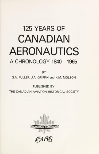
125 years of Canadian aeronautics : a chronology, 1840-1965
https://search.heritageburnaby.ca/link/museumlibrary1273
- Repository
- Burnaby Village Museum
- Collection
- Reference Collection
- Material Type
- Book
- ISBN
- 0920610021
- Call Number
- 629.1309 FUL
- Place of Publication
- Willowdale, Ont.
- Publisher
- Canadian Aviation Historical Society
- Publication Date
- c1983
- Physical Description
- xii, 328 p. : ill. (some col.) ; 26 cm.
- Inscription
- "This Book / 125 Years of Canadian Aeronautics / is one of the presentations made / to selected Canadian libraries by the / RICHARDSON CENTURY FUND / which was established in 1957 / to commemorate the / HUNDREDTH ANNIVERSARY / of / JAMES RICHARDSON & SONS, LIMITED / Thirtieth Floor, Richardson, Building, / One Lombard Place, Winnipeg, Canada / R3B 0Y1", printed on bookplate attached to cover page.
- "OKANAGAN REGIONAL LIBRARY", stamped on title page.
- "PROPERTY OF / OKANAGAN MILITARY MUSEUM", stamped on back cover page.
- Library Subject (LOC)
- Aeronautics
- Notes
- Includes indexes.
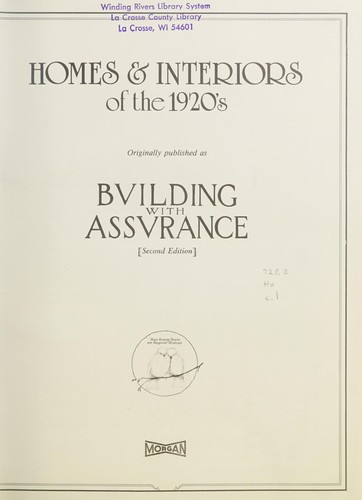
Homes & interiors of the 1920's : a restoration design guide
https://search.heritageburnaby.ca/link/museumlibrary1005
- Repository
- Burnaby Village Museum
- Collection
- Reference Collection
- Material Type
- Book
- ISBN
- 0921335121
- 0921335067
- Call Number
- 728.3 HOM
- Edition
- 2nd ed.
- Place of Publication
- Ottawa
- Publisher
- Lee Valley Tools Ltd.
- Publication Date
- c.1987
- Printer
- D.W. Friesen & Sons
- Physical Description
- 439 p. : ill. : 27.5 cm.
- Library Subject (LOC)
- Architecture
- Dwellings
- Intellior decoration
- Notes
- Originally published under title: Building with Assurance. Chicago: Morgan, 1921
- Includes index

Horse-drawn trade vehicles : a source book
https://search.heritageburnaby.ca/link/museumlibrary920
- Repository
- Burnaby Village Museum
- Author
- Thompson, John, 1937-1995
- Edition
- 2nd ed.
- Publication Date
- 1980
- Call Number
- 629.2 THO
- Repository
- Burnaby Village Museum
- Collection
- Reference Collection
- Material Type
- Book
- ISBN
- 0906922046
- 9780906922040
- Call Number
- 629.2 THO
- Edition
- 2nd ed.
- Author
- Thompson, John, 1937-1995
- Place of Publication
- Fleet
- Publisher
- J. Thompson
- Publication Date
- 1980
- Physical Description
- 62 p. : chiefly ill. ; 25 cm.
- Inscription
- "RECEIVED / 1985 APR 17 / BURNABY VILLAGE MUSEUM", stamped on front cover.
- "(BRITISH)", handwritten in ink on front cover.
- Library Subject (LOC)
- Carriages and carts--Great Britain
- Catalogs
- Notes
- On cover: No. 1 in a series of sourcebooks, containing extracts from a manufacturer's catalogue, original plans and contemporary articles on vehicle building in the 1890's.
Way Sang Yuen Wat Kee & Co.
https://search.heritageburnaby.ca/link/museumdescription4648
- Repository
- Burnaby Village Museum
- Date
- 1908-1975
- Collection/Fonds
- Way Sang Yuen Wat Kee & Co. fonds
- Description Level
- Fonds
- Physical Description
- 3 folders of textual records + 180 photographs + ephemera + 1 map + 1 architectural drawing
- Scope and Content
- Fonds consists of records acquired from the Chinese Herbalist shop “Way Sang Yuen Wat Kee & Co” operating in Victoria from 1905 until 1968. Textual records include a few pieces of correspondence, receipts and ephemera addressed to "Way Sang Yuen Wat Kee & Co.", Lim You and Lim Yau (Yew Long Lum) wh…
- Repository
- Burnaby Village Museum
- Collection/Fonds
- Way Sang Yuen Wat Kee & Co. fonds
- Description Level
- Fonds
- Physical Description
- 3 folders of textual records + 180 photographs + ephemera + 1 map + 1 architectural drawing
- Scope and Content
- Fonds consists of records acquired from the Chinese Herbalist shop “Way Sang Yuen Wat Kee & Co” operating in Victoria from 1905 until 1968. Textual records include a few pieces of correspondence, receipts and ephemera addressed to "Way Sang Yuen Wat Kee & Co.", Lim You and Lim Yau (Yew Long Lum) while the shop was in operation at 1620 Government Street in the 1940s. Some of the records are written in English while a portion are written in Cantonese and haven't been translated. Most of the photographs document the content of the original shop at the time of aquistion in 1975. Some photographs of unidentified people may be related to the owner or proprietor of the shop. A collection of other photographs document various Chinese Canadian organizations that were in operation in Victoria. Records are arranged into the following series: 1) Way Sang Yuen Wat Kee & Co. photographs series 2) Way Sang Yuen Wat Kee & Co. documents series
- History
- The Chinese Herbalist shop "Way Sang Yuen Wat Kee & Co" operated in Victoria, BC from about 1905 until [1968]. The meaning of "Way Sang Yuen Wat Kee & Co" can be translated as "Collection, Life, Source, Alive, Shop" although many interpretations can be taken since each Chinese character can have several meanings. Contents of the shop were purchased by the Burnaby Village Museum in 1975 and reassembled as a permanent display in the Burnaby Village Museum. The shop’s original owner was Ng Chee Fong who opened the shop ca.1905. In 1921, Ng returned to Hong Kong and sold the business to Lam Yuen and Wong Ying who were from Vancouver. Lam Yuen and Wong Ying employed Lum Chuck Yue to operate the shop. Lum Chuck Yue had formerly operated a small herbal counter in a Chinese apothecary store on the south side of Fisgard Street, Victoria. In 1924 Lam Yuen and Wong Ying purchased Wah Sun & Co. from Lee S. Yew and Way Sang Yuen Wat Kee & Co. moved into the Wah Sun premises at 1620 Government Street in the Lee Block . The furnishings and fixtures of both stores were combined, with the more elaborate fixtures from WSYWK remaining as part of the public part of the shop and the plainer fixtures of Wah Sun moved into the workroom and basement. In the 1930s Lum Chuck Yue took over the business and became the proprietor. In about 1934, Tan Yi Tang purchased the business and the shop reopened as Way Sang Yuen Wat Kee & Co. following renovations with Lum Yew Jong as the shop's proprietor. Lum Yew Jong continued to operate the shop until his death in 1967 at the age of 68 years. Following Lum’s death, the property and contents of the shop were purchased by Mr. J. Watson Marles, a local owner operator of an antique store at 1714 Government Street. The shop and contents went through a few more private owners including Rodney Pain before it was purchased by the Heritage Village Museum in 1975 with funds made available by the Vancouver Foundation and the Province of British Columbia. Contents of the original shop were reasembled in a reconstructed building as a permanent display on site at the Burnaby Village Museum.
- Creator
- Way Sang Yuen Wat Kee & Company
- Accession Code
- HV975.5
- BV985.5331
- BV017.7
- Access Restriction
- Restricted access
- Reproduction Restriction
- May be restricted by third party rights
- Date
- 1908-1975
- Related Material
- See also Artifacts under Accessions HV975.5; BV985.5331 and BV017.7
- Notes
- Title based on contents of fonds