Narrow Results By
Creator
- Bateman, Caroline Mary Wettenhall 1
- Burnett & McGugan, Engineers and Surveyors 3
- Fox, Colin Rhodes 1
- Girl Guides of Canada 1
- Hill, Albert James 1
- Lee, Chue Kan "Cecil" 1
- Lee, Julie Cho Chan 1
- Raymer, Roy Bernard 1
- Sanders, Alice Viola Sparman 1
- Sanders, Gerald Frank 1
- Seaforth School 1
- Stewart, Douglas 1
Oral history interview with Esther Stanley May 5, 1988 - Track 1
https://search.heritageburnaby.ca/link/museumdescription9836
- Repository
- Burnaby Village Museum
- Date
- 1925 (interview content), interviewed May 5, 1988
- Collection/Fonds
- Burnaby Village Museum fonds
- Description Level
- Item
- Physical Description
- 1 audio cassette (0:08:21 min)
- Scope and Content
- Track 1: Esther talks about the house as she remembers it from her childhood, describing the additions. Jim asks her about the furnishings of the hallway, parlour and kitchen and the contents of the pantry, and they discuss the house’s bathrooms.
- Repository
- Burnaby Village Museum
- Collection/Fonds
- Burnaby Village Museum fonds
- Series
- Jesse Love farmhouse series
- Description Level
- Item
- Physical Description
- 1 audio cassette (0:08:21 min)
- Material Details
- Interviewer: Jim Wolf Interviewee: Esther Stanley Location of Interview: not known Interview Date: May 5, 1988 Total Length of all Tracks: 36:21 Total Number of Tracks: 5
- Scope and Content
- Track 1: Esther talks about the house as she remembers it from her childhood, describing the additions. Jim asks her about the furnishings of the hallway, parlour and kitchen and the contents of the pantry, and they discuss the house’s bathrooms.
- History
- Jim Wolf talks about Love Farmhouse with Esther Stanley, daughter of Jesse and Martha Love. They discuss the property, and the furnishings, decoration and amenities of the house as she remembers them. Esther’s recollections were to be used as a resource for redecorating and refurnishing the house as it was in 1925 for its use as an exhibit at the Burnaby Village Museum. Esther’s daughters are also present at the interview.
- Creator
- Wolf, Jim
- Accession Code
- BV018.41.47
- Access Restriction
- No restrictions
- Reproduction Restriction
- May be restricted by third party rights
- Date
- 1925 (interview content), interviewed May 5, 1988
- Media Type
- Sound Recording
- Textual Record
- Related Material
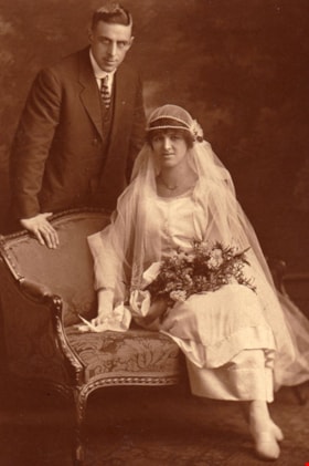
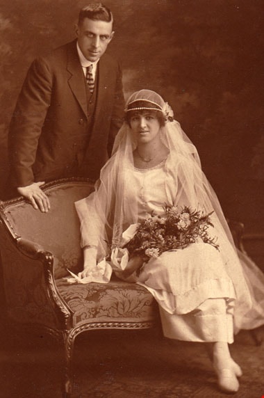
- Wedding Portrait of Frank Charles Stanley and Esther Love Stanley, 1921. Item: BV015.40.41
- Notes
- Title based on content of file
- 4 pages of interview notes accompanying oral history recording
Images
Audio Tracks
Oral history interview with Esther Stanley May 5, 1988 - Track 1, 1925 (interview content), interviewed May 5, 1988
Oral history interview with Esther Stanley May 5, 1988 - Track 1, 1925 (interview content), interviewed May 5, 1988
https://search.heritageburnaby.ca/media/hpo/_Data/_BVM_Sound_Recordings/Oral_Histories/2018_0041_0047_001.mp3
Oral history interview with Esther Stanley May 5, 1988 - Track 2
https://search.heritageburnaby.ca/link/museumdescription10400
- Repository
- Burnaby Village Museum
- Date
- 1925 (interview content), interviewed May 5, 1988
- Collection/Fonds
- Burnaby Village Museum fonds
- Description Level
- Item
- Physical Description
- 1 audio cassette (0:07:50 min) + 4 p. of textual records
- Scope and Content
- Track 2: This portion of the recording pertains to the property, Esther’s schooling, and the other members of the household. Esther recalls the house’s water supply system and Jim asks her about the gardens. They talk about the outbuildings and livestock. Esther also talks about the schools she att…
- Repository
- Burnaby Village Museum
- Collection/Fonds
- Burnaby Village Museum fonds
- Series
- Jesse Love farmhouse series
- Description Level
- Item
- Physical Description
- 1 audio cassette (0:07:50 min) + 4 p. of textual records
- Material Details
- Interviewer: Jim Wolf Interviewee: Esther Stanley Location of Interview: not known Interview Date: May 5, 1988 Total Length of all Tracks: 36:21 Total Number of Tracks: 5
- Scope and Content
- Track 2: This portion of the recording pertains to the property, Esther’s schooling, and the other members of the household. Esther recalls the house’s water supply system and Jim asks her about the gardens. They talk about the outbuildings and livestock. Esther also talks about the schools she attended. Jim asks about the family’s Christmas traditions, Esther’s siblings, the deaths of family members in the house, and Jesse Love’s work and means of transport.
- History
- Jim Wolf talks about Love Farmhouse with Esther Stanley, daughter of Jesse and Martha Love. They discuss the property, and the furnishings, decoration and amenities of the house as she remembers them. Esther’s recollections were to be used as a resource for redecorating and refurnishing the house as it was in 1925 for its use as an exhibit at the Burnaby Village Museum. Esther’s daughters are also present at the interview.
- Creator
- Wolf, Jim
- Accession Code
- BV018.41.47
- Access Restriction
- No restrictions
- Reproduction Restriction
- May be restricted by third party rights
- Date
- 1925 (interview content), interviewed May 5, 1988
- Media Type
- Sound Recording
- Textual Record
- Notes
- Title based on content of file
- 4 pages of interview notes accompanying oral history recording
Images
Audio Tracks
Oral history interview with Esther Stanley May 5, 1988 - Track 2, 1925 (interview content), interviewed May 5, 1988
Oral history interview with Esther Stanley May 5, 1988 - Track 2, 1925 (interview content), interviewed May 5, 1988
https://search.heritageburnaby.ca/media/hpo/_Data/_BVM_Sound_Recordings/Oral_Histories/2018_0041_0047_002.mp3
Oral history interview with Esther Stanley May 5, 1988 - Track 3
https://search.heritageburnaby.ca/link/museumdescription10401
- Repository
- Burnaby Village Museum
- Date
- 1925 (interview content), interviewed May 5, 1988
- Collection/Fonds
- Burnaby Village Museum fonds
- Description Level
- Item
- Physical Description
- 1 audio cassette (0:06:20 min) + 4 p. of textual records
- Scope and Content
- Track 3: Esther recalls learning to drive, and Jim asks about her father’s pipe collection and the heating arrangements of the house. They discuss the family’s music and entertainments, and the furnishings and decoration of ground floor rooms. Esther mentions her job picking fruit. Jim shows the wo…
- Repository
- Burnaby Village Museum
- Collection/Fonds
- Burnaby Village Museum fonds
- Series
- Jesse Love farmhouse series
- Description Level
- Item
- Physical Description
- 1 audio cassette (0:06:20 min) + 4 p. of textual records
- Material Details
- Interviewer: Jim Wolf Interviewee: Esther Stanley Location of Interview: not known Interview Date: May 5, 1988 Total Length of all Tracks: 36:21 Total Number of Tracks: 5
- Scope and Content
- Track 3: Esther recalls learning to drive, and Jim asks about her father’s pipe collection and the heating arrangements of the house. They discuss the family’s music and entertainments, and the furnishings and decoration of ground floor rooms. Esther mentions her job picking fruit. Jim shows the women photographs from the archives, and Esther identifies people. Jim asks about the dates of the photos and the additions to the house.
- History
- Jim Wolf talks about Love Farmhouse with Esther Stanley, daughter of Jesse and Martha Love. They discuss the property, and the furnishings, decoration and amenities of the house as she remembers them. Esther’s recollections were to be used as a resource for redecorating and refurnishing the house as it was in 1925 for its use as an exhibit at the Burnaby Village Museum. Esther’s daughters are also present at the interview.
- Creator
- Wolf, Jim
- Accession Code
- BV018.41.47
- Access Restriction
- No restrictions
- Reproduction Restriction
- May be restricted by third party rights
- Date
- 1925 (interview content), interviewed May 5, 1988
- Media Type
- Sound Recording
- Textual Record
- Notes
- Title based on content of file
- 4 pages of interview notes accompanying oral history recording
Images
Audio Tracks
Oral history interview with Esther Stanley May 5, 1988 - Track 3, 1925 (interview content), interviewed May 5, 1988
Oral history interview with Esther Stanley May 5, 1988 - Track 3, 1925 (interview content), interviewed May 5, 1988
https://search.heritageburnaby.ca/media/hpo/_Data/_BVM_Sound_Recordings/Oral_Histories/2018_0041_0047_003.mp3
Oral history interview with Esther Stanley May 5, 1988 - Track 4
https://search.heritageburnaby.ca/link/museumdescription10402
- Repository
- Burnaby Village Museum
- Date
- 1925 (interview content), interviewed May 5, 1988
- Collection/Fonds
- Burnaby Village Museum fonds
- Description Level
- Item
- Physical Description
- 1 audio cassette (0:06:28 min) + 4 p. of textual records
- Scope and Content
- Track 4: In this portion of the recording, Jim shows more photographs to Esther, including recent ones, and she identifies areas of the gardens and grounds, and outbuildings. They also look at interior photos and discuss materials and finishes. Esther notes that her brother George helped with the a…
- Repository
- Burnaby Village Museum
- Collection/Fonds
- Burnaby Village Museum fonds
- Series
- Jesse Love farmhouse series
- Description Level
- Item
- Physical Description
- 1 audio cassette (0:06:28 min) + 4 p. of textual records
- Material Details
- Interviewer: Jim Wolf Interviewee: Esther Stanley Location of Interview: not known Interview Date: May 5, 1988 Total Length of all Tracks: 36:21 Total Number of Tracks: 5
- Scope and Content
- Track 4: In this portion of the recording, Jim shows more photographs to Esther, including recent ones, and she identifies areas of the gardens and grounds, and outbuildings. They also look at interior photos and discuss materials and finishes. Esther notes that her brother George helped with the additions to the house and interiors.
- History
- Jim Wolf talks about Love Farmhouse with Esther Stanley, daughter of Jesse and Martha Love. They discuss the property, and the furnishings, decoration and amenities of the house as she remembers them. Esther’s recollections were to be used as a resource for redecorating and refurnishing the house as it was in 1925 for its use as an exhibit at the Burnaby Village Museum. Esther’s daughters are also present at the interview.
- Creator
- Wolf, Jim
- Accession Code
- BV018.41.47
- Access Restriction
- No restrictions
- Reproduction Restriction
- May be restricted by third party rights
- Date
- 1925 (interview content), interviewed May 5, 1988
- Media Type
- Sound Recording
- Textual Record
- Notes
- Title based on content of file
- 4 pages of interview notes accompanying oral history recording
Images
Audio Tracks
Oral history interview with Esther Stanley May 5, 1988 - Track 4, 1925 (interview content), interviewed May 5, 1988
Oral history interview with Esther Stanley May 5, 1988 - Track 4, 1925 (interview content), interviewed May 5, 1988
https://search.heritageburnaby.ca/media/hpo/_Data/_BVM_Sound_Recordings/Oral_Histories/2018_0041_0047_004.mp3
Oral history interview with Esther Stanley May 5, 1988 - Track 5
https://search.heritageburnaby.ca/link/museumdescription10403
- Repository
- Burnaby Village Museum
- Date
- 1925 (interview content), interviewed May 5, 1988
- Collection/Fonds
- Burnaby Village Museum fonds
- Description Level
- Item
- Physical Description
- 1 audio cassette (0:07:22 min) + 4 p. of textual records
- Scope and Content
- Track 5: Esther looks at more of the recent photographs, and talks about trees on the property and details of interiors and exteriors of the house. Jim asks about the cellar and the reservoir, and they discuss the porch and its furnishings.
- Repository
- Burnaby Village Museum
- Collection/Fonds
- Burnaby Village Museum fonds
- Series
- Jesse Love farmhouse series
- Description Level
- Item
- Physical Description
- 1 audio cassette (0:07:22 min) + 4 p. of textual records
- Material Details
- Interviewer: Jim Wolf Interviewee: Esther Stanley Location of Interview: not known Interview Date: May 5, 1988 Total Length of all Tracks: 36:21 Total Number of Tracks: 5
- Scope and Content
- Track 5: Esther looks at more of the recent photographs, and talks about trees on the property and details of interiors and exteriors of the house. Jim asks about the cellar and the reservoir, and they discuss the porch and its furnishings.
- History
- Jim Wolf talks about Love Farmhouse with Esther Stanley, daughter of Jesse and Martha Love. They discuss the property, and the furnishings, decoration and amenities of the house as she remembers them. Esther’s recollections were to be used as a resource for redecorating and refurnishing the house as it was in 1925 for its use as an exhibit at the Burnaby Village Museum. Esther’s daughters are also present at the interview.
- Creator
- Wolf, Jim
- Accession Code
- BV018.41.47
- Access Restriction
- No restrictions
- Reproduction Restriction
- May be restricted by third party rights
- Date
- 1925 (interview content), interviewed May 5, 1988
- Media Type
- Sound Recording
- Textual Record
- Notes
- Title based on content of file
- 4 pages of interview notes accompanying oral history recording
Images
Audio Tracks
Oral history interview with Esther Stanley May 5, 1988 - Track 5, 1925 (interview content), interviewed May 5, 1988
Oral history interview with Esther Stanley May 5, 1988 - Track 5, 1925 (interview content), interviewed May 5, 1988
https://search.heritageburnaby.ca/media/hpo/_Data/_BVM_Sound_Recordings/Oral_Histories/2018_0041_0047_005.mp3![East Burnaby United Church, [ca.1925] thumbnail](/media/hpo/_Data/_BVM_Cartographic_Material/2003/2003_0083_0054_001.jpg?width=280)
East Burnaby United Church
https://search.heritageburnaby.ca/link/museumdescription11932
- Repository
- Burnaby Village Museum
- Date
- [ca.1925]
- Collection/Fonds
- Ronald G. Scobbie collection
- Description Level
- Item
- Physical Description
- 1 plan : black ink and watercol. on paper ; 30.45 x 30.5 cm
- Scope and Content
- Item consists of a building insurance plan of "East Burnaby United Church / Lot 1 BK 2 south Part DL 28 GP 1 N.W.D.". Twelfth Avenue is identified to the north and Douglas Road to the west.
- Repository
- Burnaby Village Museum
- Collection/Fonds
- Ronald G. Scobbie collection
- Description Level
- Item
- Physical Description
- 1 plan : black ink and watercol. on paper ; 30.45 x 30.5 cm
- Material Details
- Scale 1 inch = 20 feet
- Scope and Content
- Item consists of a building insurance plan of "East Burnaby United Church / Lot 1 BK 2 south Part DL 28 GP 1 N.W.D.". Twelfth Avenue is identified to the north and Douglas Road to the west.
- Subjects
- Buildings - Religious - Churches
- Accession Code
- BV003.83.54
- Access Restriction
- No restrictions
- Reproduction Restriction
- No known restrictions
- Date
- [ca.1925]
- Media Type
- Cartographic Material
- Scan Resolution
- 600
- Scan Date
- 15-Jan-2021
- Scale
- 100
- Notes
- Transcribed title
- Note in pencil on verso reads: "East Burnaby United Church / Lot 1 BK 2 south Part DL 28 / 1" = 20' "
- Note in black ink on verso reads: "3704"
Images
![East Burnaby United Church, [ca.1925] thumbnail](/media/hpo/_Data/_BVM_Cartographic_Material/2003/2003_0083_0054_001.jpg)
![Map of location of Toishan Middle school, [between 1919 and 1926] thumbnail](/media/hpo/_Data/_BVM_Cartographic_Material/1985/1985_5331_0009_002%20Web.jpg?width=280)
Map of location of Toishan Middle school
https://search.heritageburnaby.ca/link/museumdescription8695
- Repository
- Burnaby Village Museum
- Date
- [between 1919 and 1926]
- Collection/Fonds
- Way Sang Yuen Wat Kee & Co. fonds
- Description Level
- Item
- Physical Description
- 1 map : blueprint ink on paper ; 41.5 x 25.5 cm
- Scope and Content
- Item consists of a topographic map with Chinese characters indicating the location of where the Toishan Middle school will be constructed. Overseas Chinese who originated from Toishan county in China participated in the fundraising efforts for the first phase of building this school (there were thr…
- Repository
- Burnaby Village Museum
- Collection/Fonds
- Way Sang Yuen Wat Kee & Co. fonds
- Description Level
- Item
- Physical Description
- 1 map : blueprint ink on paper ; 41.5 x 25.5 cm
- Material Details
- Map details include elevation contours, marsh, roads, water and rail
- Scope and Content
- Item consists of a topographic map with Chinese characters indicating the location of where the Toishan Middle school will be constructed. Overseas Chinese who originated from Toishan county in China participated in the fundraising efforts for the first phase of building this school (there were three phases in total). The block of text on the bottom right describes the geographical location of the school. It also mentions some of the amenities that they want to add to the school grounds, which requires additional funding.
- Subjects
- Buildings - Schools
- Accession Code
- BV985.5331.9
- Access Restriction
- No restrictions
- Reproduction Restriction
- No known restrictions
- Date
- [between 1919 and 1926]
- Media Type
- Cartographic Material
- Scan Resolution
- 300
- Scan Date
- December 2020
- Scale
- 100
- Notes
- Title based on contents of map
Images
![Map of location of Toishan Middle school, [between 1919 and 1926] thumbnail](/media/hpo/_Data/_BVM_Cartographic_Material/1985/1985_5331_0009_002%20Web.jpg)
![St. Margaret's Anglican Mission, [1929] thumbnail](/media/hpo/_Data/_BVM_Cartographic_Material/2003/2003_0083_0050_001.jpg?width=280)
St. Margaret's Anglican Mission
https://search.heritageburnaby.ca/link/museumdescription11928
- Repository
- Burnaby Village Museum
- Date
- [1929]
- Collection/Fonds
- Ronald G. Scobbie collection
- Description Level
- Item
- Physical Description
- 1 plan : black ink and watercol. on paper ; 30.45 x 30.5 cm
- Scope and Content
- Item consists of building insurance plan for St. Margaret of Scotland Anglican Church. Title of plan reads: "St. Margaret's Anglican Mission (note:"Church" has been crossed out and corrected with "Mission") / Lot 10, DL 132 / GP1 N.W.D." . Curtis Street is identified to the north and Sperling Av…
- Repository
- Burnaby Village Museum
- Collection/Fonds
- Ronald G. Scobbie collection
- Description Level
- Item
- Physical Description
- 1 plan : black ink and watercol. on paper ; 30.45 x 30.5 cm
- Material Details
- Scale 1 inch = 40 feet
- Scope and Content
- Item consists of building insurance plan for St. Margaret of Scotland Anglican Church. Title of plan reads: "St. Margaret's Anglican Mission (note:"Church" has been crossed out and corrected with "Mission") / Lot 10, DL 132 / GP1 N.W.D." . Curtis Street is identified to the north and Sperling Ave. to the west.
- Subjects
- Buildings - Religious - Churches
- Geographic Access
- Sperling Avenue
- Curtis Street
- Accession Code
- BV003.83.50
- Access Restriction
- No restrictions
- Reproduction Restriction
- No known restrictions
- Date
- [1929]
- Media Type
- Cartographic Material
- Scan Resolution
- 600
- Scan Date
- 15-Jan-2021
- Scale
- 100
- Notes
- Transcribed title
- Note in pencil on verso reads: "St. Margaret's Anglican Mission / Lot 10, DL 132 / 1" = 40' "
- Note in balck in on verso reads: "3704"
Images
![St. Margaret's Anglican Mission, [1929] thumbnail](/media/hpo/_Data/_BVM_Cartographic_Material/2003/2003_0083_0050_001.jpg)
![St. Nicolas Parish Church, [ca.1912] thumbnail](/media/hpo/_Data/_BVM_Cartographic_Material/2003/2003_0083_0053_001.jpg?width=280)
St. Nicolas Parish Church
https://search.heritageburnaby.ca/link/museumdescription11931
- Repository
- Burnaby Village Museum
- Date
- [ca.1912]
- Collection/Fonds
- Ronald G. Scobbie collection
- Description Level
- Item
- Physical Description
- 1 plan : black ink and watercol. on paper ; 30.45 x 30.5 cm
- Scope and Content
- Item consists of a building insurance plan of St. Nicholas Anglican Church. Title on plan reads "St. Nicolas [sic] Parish Church / Lots 11 & 12 BK 10 DL 186 GP 1 / N.W.D.". Ingleton Avenue is identified to the east and Triumph Street to the south.
- Repository
- Burnaby Village Museum
- Collection/Fonds
- Ronald G. Scobbie collection
- Description Level
- Item
- Physical Description
- 1 plan : black ink and watercol. on paper ; 30.45 x 30.5 cm
- Material Details
- Scale 1 inch = 20 feet
- Scope and Content
- Item consists of a building insurance plan of St. Nicholas Anglican Church. Title on plan reads "St. Nicolas [sic] Parish Church / Lots 11 & 12 BK 10 DL 186 GP 1 / N.W.D.". Ingleton Avenue is identified to the east and Triumph Street to the south.
- Subjects
- Buildings - Religious - Churches
- Geographic Access
- Triumph Street
- Street Address
- 3883 Triumph Street
- Accession Code
- BV003.83.53
- Access Restriction
- No restrictions
- Reproduction Restriction
- No known restrictions
- Date
- [ca.1912]
- Media Type
- Cartographic Material
- Historic Neighbourhood
- Vancouver Heights (Historic Neighbourhood)
- Scan Resolution
- 600
- Scan Date
- 15-Jan-2021
- Scale
- 100
- Notes
- Transcribed title
- Note in pencil on verso reads: "St. Nicholas Parish Church / Lots 11 & 12 BK 10 DL 186 / 1" = 20' "
- Note in black ink on verso reads: "3704"
Images
![St. Nicolas Parish Church, [ca.1912] thumbnail](/media/hpo/_Data/_BVM_Cartographic_Material/2003/2003_0083_0053_001.jpg)
Douglas Stewart fonds
https://search.heritageburnaby.ca/link/museumdescription17249
- Repository
- Burnaby Village Museum
- Date
- 1924-1951
- Collection/Fonds
- Douglas Stewart fonds
- Description Level
- Fonds
- Physical Description
- 11 cm of textual records (4 volumes)
- Scope and Content
- Fonds consists of financial ledgers belonging to Douglas Stewart regarding his personal and business affairs including the operation of "Thistle Meat Market" and ownership of other properties located on Kingsway in Burnaby between the addresses of 4018 and 4032 Kingsway.
- Repository
- Burnaby Village Museum
- Collection/Fonds
- Douglas Stewart fonds
- Description Level
- Fonds
- Physical Description
- 11 cm of textual records (4 volumes)
- Scope and Content
- Fonds consists of financial ledgers belonging to Douglas Stewart regarding his personal and business affairs including the operation of "Thistle Meat Market" and ownership of other properties located on Kingsway in Burnaby between the addresses of 4018 and 4032 Kingsway.
- History
- Douglas Stewart (1886-1976) was born in Kirkintilloch, Scotland and began working as a butcher at age twelve years. In 1905, at age nineteen years, Douglas immigrated to Canada, first settling in Calgary, Alberta. While in Alberta, John was employed with Burns Meat abattoir, feeding cattle on cattle cars which helped pay his way to Vancouver. Douglas married Jessie Reekie (1888-1975) who was also born in Scotland and the couple had three children, Annie Stewart Shore, Douglas William and Robert Malcolm who were all born in Vancouver. After arriving in Vancouver around 1913, Douglas worked at various meat markets as a butcher. In January 1925, Douglas opened a meat market which he named Thistle Meat Market (also known as Thistle Meats) located near the corner of Kingsway and Cassie Street in Burnaby. The family continued to live in South Vancouver until 1926 when they moved to Burnaby, first residing at 4022 Kingsway with the shop located at 4020 Kingsway. Over the years, Douglas owned buildings with addresses located between 4018 and 4032 Kingsway in Burnaby renting them out as businesses with some residences above. Between 1927 and 1935, Thistle Meats relocated to 4018 Kingsway and between 1927 and 1935 the family relocated their residence to 4020 Kingsway, above a business that was located next door to the shop. Between 1936 and 1953 Thistle Meats relocated to 4028 Kingsway and between 1936 and 1951, Douglas and Jessie relocated their residence to 4030 Kingsway. In 1951, Douglas retired, sold the buildings that he owned along Kingsway and moved to Grafton Street, Burnaby with his wife Jessie. Thistle meats continued to operate at 4028 Kingsway until 1958 and from 1959-1960, it operated at 4534 Kingsway. After Douglas Stewart retired in 1951, H.W. Silzer managed Thistle Meat Market until 1960. Douglas Stewart was a Mason with St. James Lodge No 80 and lifetime member of Kilwinning Lodge No. 29, Kirkintilloch, Scotland. Douglas Stewart died in Burnaby at the age of 91 years and his wife, Jessie died at the age of 87 years.
- Creator
- Stewart, Douglas
- Accession Code
- BV999.10
- Date
- 1924-1951
- Media Type
- Textual Record
- Notes
- Title based on contents of fonds

Commercial Map of Greater Vancouver and District
https://search.heritageburnaby.ca/link/museumdescription9552
- Repository
- Burnaby Village Museum
- Date
- July 1921
- Collection/Fonds
- Burnaby Village Museum Map collection
- Description Level
- Item
- Physical Description
- 1 map : col. lithograph mounted on linen ; 107 x 138 cm
- Scope and Content
- Commercial map of Greater Vancouver and District. Map depicts district lots, railroads, electric railways, streets, street car stops, schools, buildings, postal block numbers, parks and First Nations reserves. Map covers the geographcial areas of Vancouver, Burnaby, New Westminster, portions of Ric…
- Repository
- Burnaby Village Museum
- Collection/Fonds
- Burnaby Village Museum Map collection
- Description Level
- Item
- Physical Description
- 1 map : col. lithograph mounted on linen ; 107 x 138 cm
- Material Details
- Includes Legend and Index
- Scope and Content
- Commercial map of Greater Vancouver and District. Map depicts district lots, railroads, electric railways, streets, street car stops, schools, buildings, postal block numbers, parks and First Nations reserves. Map covers the geographcial areas of Vancouver, Burnaby, New Westminster, portions of Richmond, West Vancouver, North Vancouver, and Surrey with half mile circles that radiate from Vancouver City Hall on the corner of Main and Hastings. Bottom of map includes an index of street names, along with their corresponding map grid locations. The map is bordered by Marine Drive to the west, North Road to the east, Dempsey Street to the north and 20th Road to the south.
- History
- Bought by donor at thrift store years ago. No known provenance.
- Publisher
- Produced by Photo - Lithography, Colonist , Victoria, B.C.
- Geographic Access
- Vancouver
- Accession Code
- BV018.24.1
- Access Restriction
- No restrictions
- Reproduction Restriction
- No known restrictions
- Date
- July 1921
- Media Type
- Cartographic Material
- Scan Resolution
- 300
- Scan Date
- 16-Jun-20
- Scale
- 100
- Notes
- Transcribed title
- Title on map reads: "COMMERCIAL MAP / OF / GREATER VANCOUVER / AND / DISTRICT / Compiled and Published by / The Vancouver Map & Blueprint Co. Ltd. / 441 Seymour St. Vancouver B.C. / July, 1921".
Images

![Map of proposed provincial exhibition site at Burnaby Lake, [between 1929 and 1931] thumbnail](/media/hpo/_Data/_BVM_Cartographic_Material/2017/2017_0002_0009_005.jpg?width=280)
Map of proposed provincial exhibition site at Burnaby Lake
https://search.heritageburnaby.ca/link/museumdescription8703
- Repository
- Burnaby Village Museum
- Date
- [between 1929 and 1931]
- Collection/Fonds
- Burnaby Village Museum Map collection
- Description Level
- Item
- Physical Description
- 1 map : photostat print ; 3 parts 45 x 33.7 cm totalling 45 x 101 cm
- Scope and Content
- Item consists of a tri-part folding map of a proposed Provincial Exhibition site located along the southern and western shore of Burnaby Lake. Exhibtion site on map identifies proposed locations for a golf course, pier, hydroplane landing ramp, sports ground, one-mile horse racing track and various…
- Repository
- Burnaby Village Museum
- Collection/Fonds
- Burnaby Village Museum Map collection
- Description Level
- Item
- Physical Description
- 1 map : photostat print ; 3 parts 45 x 33.7 cm totalling 45 x 101 cm
- Material Details
- Scale [1:1800]
- Scope and Content
- Item consists of a tri-part folding map of a proposed Provincial Exhibition site located along the southern and western shore of Burnaby Lake. Exhibtion site on map identifies proposed locations for a golf course, pier, hydroplane landing ramp, sports ground, one-mile horse racing track and various buildings for mechanical, agricultural and botanical displays.
- Subjects
- Exhibitions
- Accession Code
- BV017.2.9
- Access Restriction
- No restrictions
- Reproduction Restriction
- No known restrictions
- Date
- [between 1929 and 1931]
- Media Type
- Cartographic Material
- Historic Neighbourhood
- Burnaby Lake (Historic Neighbourhood)
- Planning Study Area
- Burnaby Lake Area
- Scan Resolution
- 400
- Scan Date
- 2021-11-18
- Notes
- Title based on contents of map
- Scale on map reads: "150 feet to 1 inch"
- Overall measurements when fully opened: L: 98.0 cm x H: 45.3 cm ; Individual map parts: L: 32.7 cm x H: 45.0 cm
- Commercially printed label on front of portfolio card reads "PLOWRIGHT PRINTING COMPANY / TELEPHONE N.W. 1942 / 39 McKENZIE STREET NEW WESTMINSTER, B.C. / TO: [illegible writing in pencil]" in blue ink. Red typewritten text reads: "PHOTOSTAT OF BURNABY LAKE".
Images
![Map of proposed provincial exhibition site at Burnaby Lake, [between 1929 and 1931] thumbnail](/media/hpo/_Data/_BVM_Cartographic_Material/2017/2017_0002_0009_005.jpg)


![Survey and Subdivision plans in New Westminster District Group 1 – Burnaby
, [1861]-[1910] thumbnail](/media/hpo/_Data/_BVM_Cartographic_Material/1977/1977_0093_0019a_001.jpg?width=280)
Survey and Subdivision plans in New Westminster District Group 1 – Burnaby
https://search.heritageburnaby.ca/link/museumdescription6988
- Repository
- Burnaby Village Museum
- Date
- [1861]-[1910]
- Collection/Fonds
- Burnaby Village Museum Map collection
- Description Level
- File
- Physical Description
- 14 plans : 3 plans : black ink on paper hand col. + 7 plans : black ink on paper + 4 plans : graphite on paper mounted on 2 sides of cardboard 76 x 102 cm
- Scope and Content
- Item consists of a large board of four New Westminster District Gp 1 - subdivision plans mounted on one side and ten New Westminster District Gp 1 - subdivision plans mounted on the other side. Side A: 1. "Plan /of / Lots 166A, 166 and 167 /, Gr.1, N.W.D. / Showing Misconstructed Roads in Gree…
- Repository
- Burnaby Village Museum
- Collection/Fonds
- Burnaby Village Museum Map collection
- Description Level
- File
- Physical Description
- 14 plans : 3 plans : black ink on paper hand col. + 7 plans : black ink on paper + 4 plans : graphite on paper mounted on 2 sides of cardboard 76 x 102 cm
- Material Details
- Scales [between 1:2376 and 1:7920]
- Index number on edge of board reads: "19"
- Scope and Content
- Item consists of a large board of four New Westminster District Gp 1 - subdivision plans mounted on one side and ten New Westminster District Gp 1 - subdivision plans mounted on the other side. Side A: 1. "Plan /of / Lots 166A, 166 and 167 /, Gr.1, N.W.D. / Showing Misconstructed Roads in Green / 5 chs = 1 in.". (plan is drawn in black ink and hand coloured in red, green and orange ink). A section in the centre of the plan is coloured in red ink and identified as "C.S. Richmond" running from the North Arm of Fraser River to Wiggins Road and divided by "New Wiggins Rd. (as gazetted)" (coloured in orange ink) and two"Constructed Road(s)" (coloured in green ink). Plan is initialed by: "RB" [sic] (in blue pencil crayon) 2. Plan of / Subdivision of / Lot 166 / Group One / New Westminster District / Scale 4 chs = 1 in. / Map No 524". Plan is drawn in graphite and signed by "Surrig [sic] Welhams [sic] / P.L.S." Plan is initialed by: "RB" [sic] (in blue pencil crayon) 3. Plan of "Survey / of Highway / For / Burnaby Council / in / Lots 13 _14 / Group One / Scale 4 chs = 1 in." Signed by "Albert J. Hill, P.L.S." Caribou Street and Caribou Road run through the centre of the plan. Plan is stamped: "Albert J. Hill, Civil Engineer / and / Provincial Land Surveyor, / New Westminster, / B.C.". Plan is initialed by: "RB" [sic] (in blue pencil crayon) 4. A Plan of Lots 166A, 166 and 167, Group One, New Westminster District (drawn in graphite). A section in the centre of the plan is identified as "C.S. Richmond" running from the North Arm of Fraser River and divided by "New Wiggins Rd. (as gazetted)" and two "Constructed Road(s)". Plan is initialed by: "RB" [sic] (in blue pencil crayon) Side B: 1. Small plan drawn in black ink (no title) identifying lots north of the "North Arm" of the Fraser River. Lots identified include: Lot 99, Lot 98, Lot 157, Lot 158, Lot 163, Lot 162, Lot 159, Lot 163, Lot 162, Lot 165, Lot 166A, Lot 155B, Lot 155A and Lot 159. "Scale 40 chains to one inch" . Plan is initialed by: "RB" [sic] (in blue pencil crayon) (Geographic location: Burnaby) 2. Small plan drawn in black ink (no title) identifying lots north of the North Arm of the Fraser River as "Lots 155, 155A, 155B, 155C, 162, 163, 164, 165, 166A and 167". Plan is initialed by: "RB" [sic] (in blue pencil crayon) (Geographic location: Burnaby) 3. Small plan drawn in black ink (no title) which identifies "Lot 151 / Reserve/ for / Race Course"; "Reserve / 64 A / L. 152 G.1"; and other Lots: 32, 33, 34, 35, 36, 38, 39. The plan is signed "Surveyor G.Turn [sic] July / 61 / from Vol 40 R.L. notes [sic]" Plan is stamped: "Albert J. Hill, Civil Engineer / and / Provincial Land Surveyor, / New Westminster, / B.C." Plan is initialed by: "RB" [sic] (in blue pencil crayon) (Geographic location: Burnaby) 4. Small plan drawn in black in with faded red colouring on centre lot identified as "Lot 34" running north from "Vancouver Road" . Plan is stamped: "Albert J. Hill, Civil Engineer / and / Provincial Land Surveyor, / New Westminster, / B.C." Plan is initialed by: "RB" [sic] (in blue pencil crayon) (Geographic location: Burnaby) 5. Plan drawn in graphite and identified as "Lot 98, Gr.1," along with the intials "RB" [sic] (both are handwritten in blue crayon pencil on top of plan) The B.C.E.Railway is identified running through the plan along with Jubilee Road and Royal Oak Road. The plan is signed with the name "Wm. Murray" and the Plan is stamped: "Albert J. Hill, Civil Engineer / and / Provincial Land Surveyor, / New Westminster, / B.C.". (Geographic location: Burnaby) 6. Plan drawn in graphite identified as "Port Lot 13, Gr.1" along with the intials "RB" [sic] (both are handwritten in blue crayon pencil on top of plan) Plan is stamped: "Albert J. Hill, Civil Engineer / and / Provincial Land Surveyor, / New Westminster, / B.C.". (Geographic location: Burnaby) 7.Plan drawn in black ink and identified as "Lot 98 G.1" along with the intials "RB" [sic] (both are handwritten in blue crayon pencil on top of plan). A "Road Reservation" is identified running north between "Electric Tramway" and connecting with "Royal Oak Road". Plan is stamped: "Albert J. Hill, Civil Engineer / and / Provincial Land Surveyor, / New Westminster, / B.C." (Geographic location: Burnaby) 8. Plan drawn in black ink and divided into two sections, the upper plan is identified as "Portion / Lots 100 / area / 101, Gr.1" and the lower plan is identified as "Portion L. 3 G. 1" along with the intials "RB" [sic] (these identifiers are handwritten in blue crayon pencil on top of the plan). Portions of Lot 100 and Lot 101 are each divided into 6 sections and the Portion of Lot 3 plan is divided into 24 sections. The plan includes a note in black ink that reads: " Received from Wm Fromme [sic] / from Wm. Trapp / Nov. 28, 1895 / A. J. T...[sic]". (Geographic location: Burnaby) 9. Plan drawn in black ink (no title) identifying soil, buildings and geographic features in southern Burnaby. The plan is bordered by "New Westminster City" (Tenth Avenue and DL 172) to the south east and DL 173 to the south, DL 158 to the west and the B.C.E. Tramway to the north. Plan includes District Lots: 155A, 158, 159, 171, 160, 53 and 95 and identifies soil, marshland and ravines throughout. Plan identifies the following features: a "Team Road" running through Lots 158 and 159 along with "Fair Orchard Soil / Even Surface Throughout / No Ravines", "Gravel and Shingle" (bottom of Lot 158), "North Arm Road" crossing "Byrne Road" and connecting with "Power House Road" which runs north to connect with "Highland Park Station" and the B.C.E. Tramway, "Power Ho" in the northeast corner of DL 160, a "Brook" connected with a "Deep Ravine" running between DL 53, DL 95 and DL 160 along with "Good Soil" and "Fair Orchard Soil" identified nearby in DL 95. Scale is identified as "10 chs = 1 in." Plan is stamped: "Albert J. Hill, Civil Engineer / and / Provincial Land Surveyor, / New Westminster, / B.C." Plan is initialed by: "RB" [sic] (in blue pencil crayon) (Geographic location: Burnaby) 10. Plan drawn in black ink (no title) with Burnaby Lake and Deer Lake at the centre. The plan is bordered by the following District Lots identified as: 117, 118 and 68 to the west, Lots 80, 79 and 85 to the southwest, Lots 11, 13, and 1 (City of New Westminster) to the south east, the North Road boundary to the east and Lots 8, 56, 57, 59, and 136 to the North. The lower right hand corner of the plan has a small inset which reads: "Burnaby Lake" and "Page 19 R.B. Notes". Plan is initialed by: "RB" [sic] (in blue pencil crayon) (Geographic location: Burnaby)
- Creator
- Hill, Albert James
- Accession Code
- HV977.93.19
- Access Restriction
- No restrictions
- Reproduction Restriction
- No known restrictions
- Date
- [1861]-[1910]
- Media Type
- Cartographic Material
- Scan Resolution
- 300
- Scale
- 72
- Notes
- Title based on contents of file
- Scale is measured in chains. (One chain equals 792 inches)
- The term "Lot" can also refer to a "District Lot”
- Some plans are stamped: "Albert J. Hill, Civil Engineer / and / Provincial Land Surveyor, / New Westminster, / B.C." and intialed: "RB" [sic]
Images
![Survey and Subdivision plans in New Westminster District Group 1 – Burnaby
, [1861]-[1910] thumbnail](/media/hpo/_Data/_BVM_Cartographic_Material/1977/1977_0093_0019a_001.jpg)

Burnaby Girl Guides fonds
https://search.heritageburnaby.ca/link/museumdescription4614
- Repository
- Burnaby Village Museum
- Date
- 1914-2009
- Collection/Fonds
- Burnaby Girl Guides fonds
- Description Level
- Fonds
- Physical Description
- 22 scrapbooks : photographs + textual records + illustrations + digital files : col. (pdfs) + photographs : col. (tiffs) + col. (jpegs) + 222 photographs : b&w ; col. + 12 cm of textual records + ephemera
- Scope and Content
- Fonds consists of a collection of scrapbooks containing photographs, textual records, illustrations and ephemera along with individual photographs and textual records related to Burnaby Girl Guides. Records document the activities and functions of Burnaby Girl Guides through histories, journals, ne…
- Repository
- Burnaby Village Museum
- Collection/Fonds
- Burnaby Girl Guides fonds
- Description Level
- Fonds
- Physical Description
- 22 scrapbooks : photographs + textual records + illustrations + digital files : col. (pdfs) + photographs : col. (tiffs) + col. (jpegs) + 222 photographs : b&w ; col. + 12 cm of textual records + ephemera
- Scope and Content
- Fonds consists of a collection of scrapbooks containing photographs, textual records, illustrations and ephemera along with individual photographs and textual records related to Burnaby Girl Guides. Records document the activities and functions of Burnaby Girl Guides through histories, journals, newspaper clippings, certificates, awards, programmes, photographs, illustrations and newsletters. Scrapbooks were created by Burnaby Girl Guides and Girl Guide leaders and deposited with the Burnaby Girl Guide Archivist prior to being donated to the Burnaby Village Museum. Record descriptions are available at both item and file level. Fonds is arranged into the following series: 1) Burnaby Girl Guides scrapbooks and photographs series 2) Burnaby Girl Guides administrative records and histories series 3) Burnaby Girl Guides newsletters series 4) Burnaby Girl Guides memorabilia series
- History
- The Girl Guide Movement began in England in 1909 when girls in England demanded to take part in a Boy Scouts rally at the Crystal Palace in London, organized by Chief Scout and Boy Scout founder Lord Robert Baden-Powell. Following this event, Baden Powell asked his sister, Agnes Baden-Powell to help him start a similar organization for girls and Girl Guides was formed. Girl Guides came to Canada in 1910 and the first troop in British Columbia was registered in Victoria in 1912. In 1913 Amy Leigh moved to Burnaby from England and enquired about a Guiding company in her area and was disappointed to find none. On June 11, 1914 at the age of 17 years, Amy registered the 1st Burnaby Girl Guide Company and became the captain. On April 2, 1916 the 2nd Burnaby Guide Company registered and met at Edmonds School. In this same year, the very first Burnaby Girl Guide Rally event took place at Central Park and by 1920 another took place at the Burnaby Municipal Hall (Edmonds) and was attended by both Burnaby and New Westminster Guides. The First Burnaby Brownie Pack was registered on December 1922 with Mrs. W.J. Matherson as Brown Owl. The Brownie Pack met in a West Burnaby facility. The First Burnaby Land Ranger Co. was formed on November 29, 1923 and by 1924 Burnaby became a District with four Guide companies, four Brownie Packs and the Rangers. In 1923 records show Mrs. Gavin as commissioner, Mrs. C.F. Carter in 1924 and Miss Amy Leigh between 1926 and 1928. The first District camp was held near Sechelt in 1927 on the property of Mrs. Deal and Mrs. Nixon with annual camps held here until 1930 when the Guide camp at Wilson Creek was established. In 1929 Guides and Brownies began taking part in the Annual May Day Celebrations at Central Park. In 1930 Burnaby became a Division with Mrs. C.F. Carter as Division Commissioner and Mrs. G. Peel as District Commissioner for South Burnaby and in 1931 Miss Amy Leigh became the first North Burnaby Commissioner. The 5th Burnaby Girl Guide Company in North Burnaby began publishing a bulletin in 1935. In this same year Burnaby Girl Guides attended a rally for Lord and Lady Powell who were visiting Vancouver and Burnaby Girl Guides became affiliated with Greater Vancouver Girl Guide Council. The packs and companies of North Burnaby were attached to the eastern section of Vancouver while South Burnaby and South Vancouver District became another Division. Mrs. Pochin organized the Burnaby Lake District in 1943 becoming the first District commissioner (In 1927 Mrs. Peel had guides in this area). The first training classes for Girl Guides were held in 1943 in a hall on Buller Avenue at the BCER tracks and also Phillips Hall on McKay Avenue. By 1945 a training camp was held on Mrs. Pochin’s property on Deer Lake. South Vancouver, South Burnaby and Burnaby Lake Districts took part in the training which was a change over from war time service and the return of Pioneer camping. Miss E. Perition was in charge of camp which was attended by Mrs. J. Quinnell, Mrs. J. Albertson and many guiders. In 1946 Lady Baden Powel returned for a visit to Vancouver and there was a rally at Connaught Park and Chief Scout Lord Rowallyn held a rally at Brocton Point. In 1947 Mrs. J. Albertson became Division Commissioner for South Vancouver and South Burnaby. Districts of Burnaby Lake and South Burnaby each adopted a European child and undertook to send regular parcels and by 1948 these Districts became a Burnaby Division once more under Division Commissioner Mrs. W.M. Wall. In September 1949 the first Sea Ranger Crew “S.R.S. Royal Oak” was formed under the Skipper, Miss E. Periton. The S.R.S. Royal Oak met at All Saint’s Church Hall on Royal Oak Ave. In 1950 Packs and Companies in North Burnaby organized into a District under Mrs. Hebron and in 1953 Sperling District was organized by District Commissioner Mrs. Hancock. 1953 was also the same year that South Burnaby District was divided into three Districts: Central Park District under Commissioner Miss Perition, Douglas District under Commissioner Mrs. J. McKee Wilson and Kingsway under Commissioner Mrs. J.G. Fowler. A few years later, in 1955 the guides and brownies were out in force to welcome Lady Baden Powel at a rally held in the PNE Gardens building and by March 1956 Burnaby ceased to be a part of Greater Vancouver Area and was organized under two Divisions of the Province. The Sperling, Willingdon and Vancouver Heights Districts in North Burnaby became North Burnaby Division with Mrs. H. Hebron as Division Commissioner. With rapid population growth further decentralization became necessary and South Burnaby Division was split in two, adding the new division of Central Burnaby under Commissioner Miss E. Perition. Central Burnaby was composed of three Districts: Burnaby Lake, Central Park and a new District named “Windsor” under Mrs. C. Dumfries. South Burnaby was composed of three Districts: Kingsway, Edmonds and Lakeview (the latter two also referred to as Douglas with Mrs. McGeachie and Mrs. J. Park as the first commissioners of these two Districts). In 1957 Burnaby became an Area unto itself with three Divisions, and 9 Districts under Miss Periton as the first Area Commissioner. In February 1957, Burnaby entered into a contract with Vancouver Girl Guide Council to lease a part of the Wilson Creek campsite. Under the leadership of Area Commissioner, Miss Periton, work started on the development of the site with funds raised by both the Girl Guides, local citizens and associations. A camp committee was formed with representation from each Division and a lot of help from Miss Norah Weller, the Wilson Creek camp manager. Plans were laid for the site with a dining shelter, store room and cook stove contracted for while a subcommittee of men was appointed to purchase building supplies and organize work parties to build cabins, a staff house, water pipes and sanitary facilities. The site opened in May 1958 with $6000 expended on building and equipping the camp, while an official opening took place on June 8 and by July Girl Guides began camping on the site. The Burnaby Area Committee became a member of the Burnaby Community Council and a participant in Community Chest in 1958 and on May 1, the Burnaby Area office opened. By 1959, with further participation in North Burnaby, Sperling District was split to form Sperling and Hillview Districts and by 1960 Kingsway District of South Burnaby split to form Kingsway and Royal Oak Districts. By December 1960, Burnaby Area had 3 Divisions, 11 Districts with a total membership of 2, 331.
- Creator
- Girl Guides of Canada
- Accession Code
- BV015.35
- BV015.36
- BV016.49
- Access Restriction
- No restrictions
- Reproduction Restriction
- May be restricted by third party rights
- Date
- 1914-2009
- Media Type
- Textual Record
- Photograph
- Notes
- Title based on contents of fonds
- Some scrapbooks are only available in digital formats
- Accessions that form part of this fonds include: BV015.35; BV015.36; BV016.49
Jesse Love farmhouse series
https://search.heritageburnaby.ca/link/museumdescription9782
- Repository
- Burnaby Village Museum
- Date
- [1893-1970] (date of originals), copied 1988-1998, predominant 1988-2000
- Collection/Fonds
- Burnaby Village Museum fonds
- Description Level
- Series
- Physical Description
- approx. 84 cm of textual records + approx. 1,910 photographs + approx. 100 architectural drawings + 3 audio cassettes + 1 videocassette
- Scope and Content
- Series consists of records involved in the purchase, moving, restoration, research, conservation and exhibiting of the Love family farmhouse by Burnaby Village Museum. Records have been arranged into the following subseries: 1) Love farmhouse conservation work files subseries 2) Love farmhouse re…
- Repository
- Burnaby Village Museum
- Collection/Fonds
- Burnaby Village Museum fonds
- Series
- Jesse Love farmhouse series
- Description Level
- Series
- Physical Description
- approx. 84 cm of textual records + approx. 1,910 photographs + approx. 100 architectural drawings + 3 audio cassettes + 1 videocassette
- Scope and Content
- Series consists of records involved in the purchase, moving, restoration, research, conservation and exhibiting of the Love family farmhouse by Burnaby Village Museum. Records have been arranged into the following subseries: 1) Love farmhouse conservation work files subseries 2) Love farmhouse restoration photographs subseries 3) Love farmhouse curatorial files subseries 4) Love farmouse research files subseries 5) Love family photographs 6) Love farmhouse Oral History subseries 7) Love farmhouse architectural drawings subseries
- History
- Jesse Love was born in Swindon, England in 1847 and left England to work on a dairy farm in the Toronto area. While working on the farm in Toronto, he met Martha Leonard who he married in 1879. Martha was born on February 3, 1858 in Bedfordshire, England and had come to Canada with her parents George and Ann Leonard. While living in Toronto, Jesse and Martha had two children, George born March 22, 1880 and Annie Elizabeth on August 24, 1881. About one year after Annie was born, the Love family moved to North Dakota to grow wheat. While living there, they had two more children, Henry who was born August 24, 1883 and Edith Minnie born October 9, 1885. The family decided to move further west after hearing about the fairer weather conditions from Martha’s father, George Leonard, who had settled in Vancouver in 1885. On May 23, 1887, Jesse, Martha and their four children arrived in Vancouver after travelling across Canada from Winnipeg on the first transcontinental train. The Loves made their home in Vancouver while Jesse helped clear land on Granville Street. Their fifth child, Thomas Robert was born on September 17, 1887 and soon after, the family moved to Lulu Island in Richmond where they lived growing vegetables and selling them to Vancouver hotels. While living and farming on Lulu island, the couple had two more girls, Martha (Dot or Dorothy) born on December 17, 1889 and Sarah Marie, born February 8, 1892. On October 6, 1893 an agreement was signed by Jesse Love to purchase 14.52 acres of land from Joseph C. Armstrong. The acreage covered the north east section of District Lot 25 within the newly incorporated District of the Municipality of Burnaby. It was here where the original Love house was built (between October 1893 and April 15, 1894) by Jesse Love with the help of local builder George Salt and father in law, George Leonard. The house consisted of an entrance hall, dining room, lean to kitchen, master bedroom and three bedrooms upstairs. A road was constructed and named Cumberland in 1905 and ran from District Lot 25 through to District Lot 11. The address for the Love home was 1390 Cumberland Road and in the early 1960’s the address was renumbered 7651 Cumberland Street. On the land surrounding the house, Jesse Love planted an orchard along with strawberries and raspberries which he sold at the Fraser Valley Market, T.S. Anandale’s Grocery Store in New Westminster and to hotels around Vancouver. Jesse Love served on the Burnaby School Board and also as a District Councillor in 1901 and from 1904-1907. While living in the house, Jesse and Martha had four more children, Phoebe Leonard, born April 15, 1894, Esther, born August 28, 1896, John Leonard, born June 7, 1899 and Hannah Victoria (also known as Girlie) who was born May 12, 1902. As the family grew to eleven children, additions along with some substantial remodelling in the craftsman style took place. In about 1898, a north wing addition was added to include a parlour with two windows, the construction of two more bedrooms and the relocation of the stair case to the North West wall. In 1903 the front door moved to the north elevation, a front porch was extended along the east wall and a summer lean to kitchen was added to the west elevation. Between 1905 and 1910, a tin embossed ceiling was installed along with an addition of the main kitchen which included a pantry, bathtub and a back porch. In about 1912, five craftsman style windows replaced the original pioneer tent style, the front verandah was enlarged to wrap around the south and east elevations, a back door was installed in the kitchen to access the verandah and wood shingle siding and brackets were added to the exterior. In 1918, at the age of 31 years, Robert Love fell ill due to an influenza epidemic and died on November 23, 1918. Following their son’s death, Martha Love became weak and on August 24, 1920, she passed away. By this time, Jesse had sold off a large percentage of his land and his youngest daughter, Girlie decided to stay on to live and care for him. Since the house was too large for just the two of them, Jesse invited any other children to return and share the residence. For a while his son, George and his wife joined them until 1925, followed by his daughter Sarah Parker (nee Love), her husband William and their three children, Albert, Bill and Elsie. The house remained pretty unchanged until 1928 after Jesse Love died of pneumonia (March 10, 1928) and the house was purchased by Sarah and her husband William Parker who continued to live there with their children. The master bedroom wall on the main floor opened up to the dining room, the kitchen pantry and bathtub converted to an alcove with a marble counter and enlarged window and sink while the bathroom was moved to the upstairs and the furnace and coolers were installed in the crawl space under the kitchen. A hot water tank was installed in the house in 1966. Sarah continued to live in the house until a little while after her husband William died in 1961. She sold the house to her daughter Elsie and husband John Hughes in 1966, who lived in the house along with their son Brent, until August 23, 1971. Mahbir Molchan Papan and his wife Geraldine Papan bought the house August 23, 1971 and by 1982, the house was sold to Nirmal Singh Singha and Narinder Singha. The Papans continued to rent the house from Nirmal Singh Singha and Narinder Singha until the late 1980s. In 1988, the house was scheduled for demolition with the remaining property to be subdivided. Fortunately, a neighbour, Mr. Harvey Elder recognized the farmhouse's historical significance and contacted the Burnaby Historical Society. Following this event, the owners agreed to donate the building to the Burnaby Village Museum (under the Century Park Museum Association) who financed the move of the house from Cumberland Street to the museum site. Heritage planner and architect, Robert Lemon provided guidance for the project. Prior to the move, the two porches were removed and demolished while the kitchen and roof were both separated from the main house. The kitchen and roof of the house were transported to Burnaby Village Museum on May 20, 1988 by Nickel Bros. House Moving company, while the main frame of the house completed its transportation to the museum near the end of May 1988 (due to low overhead wires). The house was moved down Cumberland Street to 10th Avenue, up Canada Way to Sperling and set on temporary footings near Hart House. Robert Lemon oversaw structural improvements such as, upgrading floor joists and creating new foundations to replace the original timber foundation of the farmhouse. The restoration went through several phases of work between 1988 until it opened in November 1998. Restoration began on both the interior and exterior features to be interpreted from the period of 1925. On November 23, 1992, the building was designated a heritage building under Heritage Designation Bylaw 1992, Bylaw Number 9807. In 1993, the architecture firm of Brian G. Hart Associates was appointed for the design and construction supervision of the restoration project. Plans were created for a foundation on the museum site in 1989 and the farmhouse was eventually settled on a permanent foundation behind the Burnaby Village Museum administration building in 1993 along with the reattachment of the roof. The kitchen section was reattached to the main house in 1994 along with skirting around the foundation and the reshingling of the exterior. In 1996, the tin ceiling was removed to make way for the installation of the internal electrical system along with sprinklers, ceiling heating and fire break gyprock. The dining room ceiling joists were consolidated, a pantry and bathroom were added to the kitchen, the downstairs bedroom wall was opened and filled, the dining and kitchen doorways were widened. In 1997, a wheelchair ramp was installed along with a concrete sidewalk, stair rails, cement pads at the base of the stairs and a gravel sink for any excess water. Interior work included painting of the kitchen, restoration and furnishing of the kitchen pantry, insulation of the house floor to protect from rodents along with the reconstruction of the kitchen and house chimneys. The registrar worked together with the curator and conservator and was tasked with a large research project on the house including the family contacts and family history, property information, plans, photographs, artifacts, furnishings, stories etc. all organized in files for easy retrieval. A great deal of research and conservation was undertaken in order to make the interior of the house authentic to the time period as possible. One of the biggest projects was selecting and obtaining wall coverings since much of the original wallpaper was incomplete and poor condition. The conservator and registrar were lucky enough to locate a few samples of the original paper and engage the Bradbury and Bradbury Art Wallpaper Company of Benica, California to reproduce replica designs for free. The City of Burnaby now has its own series “Burnaby Village Papers” produced by this company which are titled “Burnaby Wall”; “Burnaby Border” and “Burnaby Ceiling”. All three of these wallpaper designs have been used in the Love farm house and are also commercially available through the Bradbury and Bradbury Art Wallpaper Company. In 1997, restoration of the kitchen was completed and opened to the public. After the completion of the dining room, main floor bedroom and parlour, the Love farmhouse exhibit opened on November 29, 1998 with an open invitation to the public and extended members of the Love family. Officials including the Mayor, Doug Drummond and Love family members were all present to cut the ribbon for the special event.
- Accession Code
- BV018.41; BV020.5
- Access Restriction
- Restricted access
- Date
- [1893-1970] (date of originals), copied 1988-1998, predominant 1988-2000
- Arrangement
- The majority of the records within series and subseries were arranged by a staff members of Burnaby Village Museum who worked on the historical research and restoration of the house. Other photographs documenting the move and further restoration work were added later and included in the arrangment by format and subject.
- Notes
- Title based on content of series
- Jesse Love farmhouse is described as an Artifact under BV988.33.1
- Some records within this collection have restricted access and are subject to FIPPA
- Accessions BV018.41 and BV020.5 form this fonds
E.W. Bateman family fonds
https://search.heritageburnaby.ca/link/museumdescription15157
- Repository
- Burnaby Village Museum
- Date
- [1857]-[195-]
- Collection/Fonds
- E.W. Bateman family fonds
- Description Level
- Fonds
- Physical Description
- 63 photographs + 6 cm of textual records
- Scope and Content
- Fonds consists of photographs of the family of Edwin Wettenhall Bateman and residences including Elworth house, along with letters written by Colin Rhodes Fox during World War II. Fonds is arranged into the following series: 1) Bateman family photographs series 2) Bateman family World War II lette…
- Repository
- Burnaby Village Museum
- Collection/Fonds
- E.W. Bateman family fonds
- Description Level
- Fonds
- Physical Description
- 63 photographs + 6 cm of textual records
- Scope and Content
- Fonds consists of photographs of the family of Edwin Wettenhall Bateman and residences including Elworth house, along with letters written by Colin Rhodes Fox during World War II. Fonds is arranged into the following series: 1) Bateman family photographs series 2) Bateman family World War II letters series
- History
- Edwin Wettenhall "E.W." Bateman was born in 1859 in Sandbach, Cheshire, to James and Caroline Mary Wettenhall Bateman (their home in Sandbach was called Elworth Cottage). When he was twenty-one, E.W. Bateman immigrated to Manitoba, Canada where he met Catherine “Cassie” Dale, daughter of George and Sarah Gillon Dale. They were married in Portage La Prairie, Manitoba on November 9, 1886. Edwin and Cassie had seven children, the eldest Edna Caroline Annie (Corner) (1889-1969); George Edwin (1890-? ); Mamie (McWilliams) (1892-1979); Marianne “May” Bateman (1894-1990); Warren Stafford (1896-1954); Jessie (Fox Kemp) (1899-1978) and John Carey (1901-1945). Catherine “Cassie” (Dale) Bateman died in Portage La Prairie in 1909. After Cassie's death, Edwin was transferred to Vancouver by the Canadian Pacific Railway where he married Cassie’s younger sister Mary Dale (1896-1935). Edwin moved his six of his seven children to Vancouver (not including George). Edwin and Mary (Dale) Bateman first lived at 7th and Balsam Street in Vancouver and in 1920, they decided to move to the quieter atmosphere of the Burnaby Lake- Deer Lake area. By this time Edwin Wettenhall Bateman was a retired CPR executive. He moved his wife and daughter Marianne “May” Bateman to Deer Lake and commissioned architect, Enoch Evans to build 'Elworth' house (named after Edwin’s family home in Sandbach, Chesire). The house was completed by contractor William Dodson in 1922 and located at the site of what would become Heritage Village and later, Burnaby Village Museum, 6501 Deer Lake Avenue. The Batemans lived at this location for thirteen years before moving back to Vancouver in May of 1935. Mary Dale Bateman died in July 1935 and sometime after, Edwin W. Bateman married Dora Coulton. Edwin W. Bateman died in 1957 at the age of 98. Edna Caroline Bateman married Raymond Westley Corner in 1920 and had a daughter named Catherine Mary (Levins). Edna and Raymond lived in Kelowna. George Bateman married Louise Agness Birss in January 1910 and continued to live in Manitoba. Mamie Dale Bateman married George Lloyd McWilliams in 1915. The couple had two children, Warren Finley McWilliams and Bruce McWilliams. Mamie and George McWilliams lived with their family on Douglas Road across the road from Elworth house in Burnaby. Warren McWilliams was on North Atlantic convoy duty during World War I from 1942 to 1944. Warren McWilliams died in 2004. Warren Stafford Bateman married Norah Withington in Burnaby in 1924; Winifred Dare Webster in Burnaby in 1932 and Dorothy Margaret Buchanan in New Westminster in 1949. Warren and Winnifred “Winnie” Webster celebrated their marriage at Elworth house in 1932. Warren served in World War I. Jessie Madeline Bateman married Ernest Denby Fox (1900-1945) in 1921. Jessie and Ernest Fox had three children, Colin Rhodes Fox (1921-2005); Mary “Betty” (Gludo) and Allan Fox. Jessie and Ernest Fox operated a small logging company near Powell River, B.C. Sometime after the death of her first husband, Ernest Denby Fox, Jessie married James Kemp. The youngest child of Edwin and Cassie, John “Carey” Bateman married Sophia Spak (1899-1977) in 1925. On September 10, 1939, the day that Canada declared war on Germany, Colin Rhodes Fox (eldest son of Jessie and Ernest Fox) enlisted in the army at the age of 18 years. Colin initially served in an anti-aircraft unit, but was soon transferred to the Field Artillery. During his service overseas, Colin wrote letters to family members including his aunt May Bateman who was living in Burnaby. Colin went through basic artillery training in Edmonton before heading overseas to the United Kingdom with his unit, the 13th Field Regiment , 44th Canadian Field Battery of the Royal Canadian Artillery and later the 78th Canadian Field Battery in Germany and Holland . Colin was wounded on June 8, 1944 (two days after D-Day) but returned to serve in Holland and Germany until the war ended. Colin suffered bullet and shrapnel wounds while laying communication cable from the Normandy beachhead. In 1946, Colin married Susan Streika (Striha) of Pitt Meadows and he began a thirty five year career in the B.C. Telephone Company on Vancouver Island. Colin and Susan had three children; Gary, Elaine and Irene. Colin Rhodes Fox died in 2005. The E.W. Bateman house, "Elworth" is a heritage building on the site of the Burnaby Village Museum. The site is an important cultural feature for the interpretation of Burnaby’s heritage to the public. The E.W. Bateman House was purchased by Burnaby in 1970 and became the focal point for the development of the Museum. Both the interior and exterior of the house have been restored and interpreted to the date of original construction, including recreated room interiors and period furnishings.
- Accession Code
- HV974.22
- HV974.90
- HV975.120
- HV976.37
- HV979.32
- BV985.1003
- BV986.21
- BV992.29
- BV994.22
- BV004.28
- BV004.84
- BV020.27
- Date
- [1857]-[195-]
- Media Type
- Photograph
- Textual Record
- Related Material
- See also: Interview with Marianne May Bateman February 22, 1978 - Tracks 1-4. City of Burnaby Archives Item No. MSS137-014-1
- Notes
- Title based on contents of fonds
Julie Lee and Cecil Lee family fonds
https://search.heritageburnaby.ca/link/museumdescription14764
- Repository
- Burnaby Village Museum
- Date
- 1920-2006, predominant 1920-1979
- Collection/Fonds
- Julie Lee and Cecil Lee family fonds
- Description Level
- Fonds
- Physical Description
- 6 photographs : col. + 1 photograph : b&w + 1 photograph : sepia + 41 photographs (tiffs) + 4 photographs (jpgs) + 12 cm of textual records
- Scope and Content
- Fonds consists of family photographs of the Jung, Chan and Lee families as well as business records collected and created by Cecil Lee in the nineteen seventies, while he was employed as a Produce Buyer for Kelly Douglas Limited and Western Commodities Limited and responsible for the import of Chin…
- Repository
- Burnaby Village Museum
- Collection/Fonds
- Julie Lee and Cecil Lee family fonds
- Description Level
- Fonds
- Physical Description
- 6 photographs : col. + 1 photograph : b&w + 1 photograph : sepia + 41 photographs (tiffs) + 4 photographs (jpgs) + 12 cm of textual records
- Scope and Content
- Fonds consists of family photographs of the Jung, Chan and Lee families as well as business records collected and created by Cecil Lee in the nineteen seventies, while he was employed as a Produce Buyer for Kelly Douglas Limited and Western Commodities Limited and responsible for the import of Chinese mandarin oranges. Fonds is arranged into the following series: 1) Lee family photographs series 3) Cecil Lee business records series
- History
- Julie Cho Chan Lee is the daughter of Suey Ying Jung (Laura) (1912-2006) and Puy Yuen Chan (1903-1978). Suey Ying "Laura" and Puy Yuen Chan were married in New Westminster in November 1942 followed by a fourteen year residency in the “minority town site” of Fraser Mills where their daughters Julie and June were born. Julie's mother Suey Ying "Laura" Jung was born in Burnaby in 1912 to Chung Chong Jung (1875-1956) and Gee Shee Jung (1879-1952). The family had six children (five of which lived to adulthood); Suey Fong "Maida" (1909-1997) (married Quinn Wong) ; Suey Kin "Annie" (1911-1962) (married George Jong); Suey Ying "Laura"; Suey Cheung "Harry" (1916-1991) and "; Suey Yook "Gordon" (1919-1998). The family owned and operated a five acre market garden and piggery at 5460 Douglas Road near Still Creek (address was changed to 5286 Douglas Road in 1958). This was conveniently located directly across the street from Douglas Road Interurban Station. The children attended Edmonds Elementary School and while the girls only completed their elementary school years, the boys continued their education at the Vancouver Technical School. Chung Chong and Gee Shee Jung sold the farm on Douglas Road around 1949 and moved to East Vancouver. Julie's mother, Suey Ying "Laura" Jung continued to live and work on the Jung family farm until she was married in 1942 when she moved to live with her husband, Puy Yuen at Fraser Mills. Suey Ying "Laura"'s sister Maida and her husband Quinn Wong also lived at Fraser Mills with their nine children. Julie's father, Puy Yuen Chan joined his father, Chin Yip Hong in Canada at the tender age of 12, worked as a shingle packer and plywood plant handler at Fraser Mills for forty years and retired without ever learning to speak English. In 1972, Julie Cho Chan married Cecil Lee and lived in Surrey where their two boys, Rodney and Darin were born. Just prior to the start of school for Rodney, the family relocated to Coquitlam where Julie had lived since 1956. Julie worked as a teacher and later as a teacher-librarian in the Coquitlam School District. Cecil Chue Kan Lee was born in Queensborough to Sui Seo Ngen and Ding Quai Lee. Cecil is the youngest of eight children; Chue Ngan "Gladys"; Chue Fay "Walter"; Chue Quon "Charlie"; Chue Jan "Pearl"; Chue Moi "Rose"; Chue Duck "Dick" and Chue Kwong "Ken". Cecil’s father, Ding Quai Lee was a jack of all trades including a labour contractor as a well as a millwright for G.W. Beach’s three mills, Keystone, Sapperton and Harrison Mills.In 1931, with the arrival of the Depression, the family made the difficult decision to return to their homeland of Guangzhou province, eventually returning to Canada in 1939. With this decision, Ding Quai wrestled with the burden of the repayment of the loans for two way steamship fares to and from China. Upon their return to Canada, the family lived a short time on Union Street in Vancouver before relocating to Queensborough (New Westminster). Cecil and his siblings were schooled at Queen Elizabeth Elementary School followed by varying stints at FW Howay and Duke of Connaught High Schools. In 1951, Cecil Lee joined Kelly Douglas & Company Ltd., a subsidiary of the George Weston Empire, as a produce warehouseman, followed by several years as a foreman and then in the early seventies until his 1991 retirement after forty years of service, he served as one of the KD produce buyers. In this capacity, he worked closely with local farmers along Marine Drive and in the Fraser Valley. Kelly Douglas and Company Limited was founded in 1896 as a wholesale grocery business and became one of the largest food distributors in Canada. In 1946, its headquarters moved from Vancouver to Burnaby and a manufacturing plant and warehouse were built on the site at 4700 Kingsway. In the mid-1970s, Lee along with the associates at Western Commodities, the head office for produce imports, was asked to oversee the import of Chinese mandarin oranges into western Canada. Until that time, mandarin oranges had come only from Japan and were sold in the winter, especially at Christmas. When the Japanese market could no longer keep up with the popular demand, Kelly Douglas and Company Limited looked to China. The company relied on Lee’s cultural knowledge to build this very profitable part of their business. Moreover, Cecil Lee designed, though not patented, the cardboard Chinese mandarin orange box to replace wooden containers. The iconic design required no glue or staples, making it possible for farmers to assemble and pack the boxes as they picked the oranges. In 1986, the Kelly Douglas and Company building was demolished and the produce department of Kelly Douglas was relocated to 6451 Telford Burnaby and the head office to 808 Nelson Street, Vancouver.
- Accession Code
- BV017.24; BV019.6; BV019.33; BV020.38; BV021.19
- Date
- 1920-2006, predominant 1920-1979
- Media Type
- Photograph
- Textual Record
- Arrangement
- Records within fonds are composed of business records and family photographs arranged by the Lee family.
- Notes
- Title based on contents of fonds
- See also: Interview with Julie Lee by Denise Fong February 6, 2020. -- [1920-1992] (interview content), interviewed Feb. 6, 2020 BV020.6.2
- See also artifact descriptions under accession BV019.6 including BV019.6.1 - for description of original box to ship and sell mandarin oranges; BV019.6.15 and BV019.6.16 for Chinese mandarin orange wrappers "Snow Mountain Mandarin Orange"
- Many of the "Business records" are closed and subject to FIPPA, contact Burnaby Village Museum regarding access
Letter re Special Survey of District Lots 9, 55, 106 and 107
https://search.heritageburnaby.ca/link/museumdescription11144
- Repository
- Burnaby Village Museum
- Date
- December 1927
- Collection/Fonds
- Ronald G. Scobbie collection
- Description Level
- Item
- Physical Description
- 1 p. of textual records
- Scope and Content
- Item consists of a letter dated 13th December 1927 with letterhead "McQuarrie, Whiteside & Duncan / Barristers & Solicitors", "New Westminster Office / Westminster Trust Building / Mission City Office / Catherwood Building / New Westminster, B.C.."; addressee "Messrs. Burnett & McGugan, Surveyors /…
- Repository
- Burnaby Village Museum
- Collection/Fonds
- Ronald G. Scobbie collection
- Description Level
- Item
- Physical Description
- 1 p. of textual records
- Scope and Content
- Item consists of a letter dated 13th December 1927 with letterhead "McQuarrie, Whiteside & Duncan / Barristers & Solicitors", "New Westminster Office / Westminster Trust Building / Mission City Office / Catherwood Building / New Westminster, B.C.."; addressee "Messrs. Burnett & McGugan, Surveyors / 30 McKenzie Street, CITY" "ATTENTION MR. BURNETT."; "Re: Special Survey of District Lots 9, 55, 106 and 107. Group 1, New Westminster District, District of Coquitlam".
- Accession Code
- BV003.83.23
- Access Restriction
- No restrictions
- Reproduction Restriction
- No known restrictions
- Date
- December 1927
- Media Type
- Textual Record
- Notes
- Title based on contents of item
Gerald F. Sanders and Alice Sparman Sanders fonds
https://search.heritageburnaby.ca/link/museumdescription18831
- Repository
- Burnaby Village Museum
- Date
- 1918-2016
- Collection/Fonds
- Gerald F. Sanders and Alice Sparman Sanders fonds
- Description Level
- Fonds
- Physical Description
- 33 photographs + 7 architectural drawings +1 cm of textual records
- Scope and Content
- Fonds consists of family photographs and personal papers pertaining to Gerald Frank Sanders and Alice Viola Sparman Sanders along with architectural plans pertaining to the family home located on Spruce Street in Burnaby. Fonds has been arranged into the following series: 1) Sanders-Sparman photog…
- Repository
- Burnaby Village Museum
- Collection/Fonds
- Gerald F. Sanders and Alice Sparman Sanders fonds
- Description Level
- Fonds
- Physical Description
- 33 photographs + 7 architectural drawings +1 cm of textual records
- Scope and Content
- Fonds consists of family photographs and personal papers pertaining to Gerald Frank Sanders and Alice Viola Sparman Sanders along with architectural plans pertaining to the family home located on Spruce Street in Burnaby. Fonds has been arranged into the following series: 1) Sanders-Sparman photographs series 2) Sanders family personal papers 3) Sanders family architectural drawings
- History
- Gerald Frank Sanders (1916-2017) was born August 28, 1916 in Hackney, London. In 1918, Gerald immigrated to Canada with his mother Harriett Sanders (nee Chalkley) (1889-1962) while his father, Frank (1887-1967) was convalescing in hospital in England after succumbing to wounds while serving in action during WWI. Gerald's father, Frank soon joined them in British Columbia. In 1926 they settled in a house located at 4312 Spruce Street near the corner of Spruce Street and Carleton Avenue. By 1946 the family grew in size to four children (Gerald, Leslie, Reginald and Eileen) and they built a larger house right on the corner of Spruce and Carleton Avenue. Gerald attended Inman Elementary, then Van Technical School. He eventually joined the RAF during WWII as an airplane mechanic in England. He sent his pay home and his mother purchased two lots on Pine Street with some of the money. On March 8, 1948 Gerald married Alice Viola Sparman (1925-1996) and the couple lived in the Sanders' family home on Spruce Street. Alice grew up near Cranbrook and spent her teenage years in Victoria. She trained to be a nurse at St. Paul’s Hospital in Vancouver before marrying Gerald. Alice worked at the Burnaby General Hospital from 1952. Gerald and Alice had six children: Dennis, Kris, Kerry, David, Ruth and Marie. In 1949 with the help of family and friends Gerald built a new house located at 4325 Pine Street (address after 1959- 4091 Pine Street) and he moved in with his family. Gerald worked as a carpenter on various projects including the dentistry building at University of British Columbia, the Vancouver Court House and Jack Poole's house in the British Properties. Gerald lived in Burnaby until his death in 2017. Frank and Harriett Sanders lived on Spruce Street until Harriett died in 1962. Frank continued to live on Spruce Street until 1964 and then lived with his son Gerald on Pine Street until his death in 1967.
- Accession Code
- BV018.34
- Date
- 1918-2016
- Media Type
- Photograph
- Architectural Drawing
- Textual Record
- Arrangement
- Records and series were arranged by specific record types.
- Notes
- Title based on contents of fonds
Roy Bernard Raymer fonds
https://search.heritageburnaby.ca/link/museumdescription18930
- Repository
- Burnaby Village Museum
- Date
- [1921]-1959
- Collection/Fonds
- Roy Bernard Raymer fonds
- Description Level
- Fonds
- Physical Description
- 2 photographs + 1p. of textual records + 2 architectural drawings
- Scope and Content
- Fonds consists of photographs, documents and architectural plans regarding the Oasis Tea Garden and Tourist Camp and a photograph of Burnaby Reeve Alexander K. McLean. Fonds is arranged in series: 1) Ray Raymer photograph collection series 2) Ray Raymer business records series
- Repository
- Burnaby Village Museum
- Collection/Fonds
- Roy Bernard Raymer fonds
- Description Level
- Fonds
- Physical Description
- 2 photographs + 1p. of textual records + 2 architectural drawings
- Scope and Content
- Fonds consists of photographs, documents and architectural plans regarding the Oasis Tea Garden and Tourist Camp and a photograph of Burnaby Reeve Alexander K. McLean. Fonds is arranged in series: 1) Ray Raymer photograph collection series 2) Ray Raymer business records series
- History
- Roy Bernard Raymer (1915-1991) is the son of Harvey Connor Raymer (1885-1937) and Bernice Mildred McFarland. The family owned and operated the Oasis Tourist Cabins on Kingsway. The family moved to Minnesota temporarily and then finally settled in Burnaby in 1921. The family bought their property at 2675 Kingsway (later 6111 Kingsway) and started first a roadside stand called "Golden Rule Table Supply" that sold milk, eggs, etc that came from the family's cows, chicken, etc on the property. From the roadside stand the family progressed to a larger building, a restaurant and store complex. Added to this was a "free campground" where visitors could pitch tents and become customers for the store and resturant. The campground eventually became British Columbia's first motel when ten "tourist cabins" were built on the property. Roy and his brother Max Raymer (1917-1935) attended Edmonds East School in the 1920s. By the late 1920s, the restaurant had expanded to include a dance floor section and it became one of the Lower Mainland's favorite night spots. The new complex was renamed as "The Oasis". In the 1930s, a gasoline retailing outlet was added which became one of Greater Vancouver's largest volume outlets. After the death of his brother, Max at age 18 in 1935 and his father, Harvey in 1937, Roy and his mother Bernice ran the business. After the death of his mother, Bernice in 1951, Roy leased the property for revenue. In 1955, Roy married Ingeborg Haacke and lived on the Kingsway acre and raised a family of four children. For a time they operated the property as "the Oasis Donut Drive-In". In 1964, the property was sold and the family moved to Government Road. Roy Bernard Raymer died in 1991.
- Responsibility
- Raymer, Roy Bernard
- Accession Code
- HV977.121
- Date
- [1921]-1959
- Media Type
- Photograph
- Architectural Drawing
- Textual Record
- Notes
- Title based on contents of fonds