Narrow Results By
Subject
- Advertising Medium - Signs and Signboards 5
- Buildings - Commercial 4
- Buildings - Commercial - Grocery Stores 3
- Buildings - Commercial - Restaurants 2
- Buildings - Commercial - Stores 1
- Buildings - Heritage 1
- Buildings - Residential 26
- Buildings - Residential - Apartments 22
- Buildings - Residential - Houses 7
- Construction 1
- Geographic Features - Lanes 1
- Geographic Features - Roads 1

New regulations at work site
https://search.heritageburnaby.ca/link/archivedescription95095
- Repository
- City of Burnaby Archives
- Date
- April 16, 2020
- Collection/Fonds
- Burnaby Photographic Society fonds
- Description Level
- Item
- Physical Description
- 1 photograph (tiff)
- Scope and Content
- Photograph of signs attached to security fencing outside the closed Schou Education Centre on Canada Way. Signs are handwritten and contain COVID-19 site safety protocols. Photograph was taken from Norfolk Street, facing south.
- Repository
- City of Burnaby Archives
- Date
- April 16, 2020
- Collection/Fonds
- Burnaby Photographic Society fonds
- Physical Description
- 1 photograph (tiff)
- Description Level
- Item
- Record No.
- 623-014
- Access Restriction
- No restrictions
- Reproduction Restriction
- No restrictions
- Accession Number
- 2020-10
- Scope and Content
- Photograph of signs attached to security fencing outside the closed Schou Education Centre on Canada Way. Signs are handwritten and contain COVID-19 site safety protocols. Photograph was taken from Norfolk Street, facing south.
- Media Type
- Photograph
- Photographer
- Damer, Eric
- Notes
- Transcribed title
- Geographic Access
- Gilmore Avenue
- Canada Way
- Street Address
- 4054 Norfolk Street
- Historic Neighbourhood
- Broadview (Historic Neighbourhood)
- Planning Study Area
- Cascade-Schou Area
Images

E.W. Bateman family fonds
https://search.heritageburnaby.ca/link/museumdescription15157
- Repository
- Burnaby Village Museum
- Date
- [1857]-[195-]
- Collection/Fonds
- E.W. Bateman family fonds
- Description Level
- Fonds
- Physical Description
- 63 photographs + 6 cm of textual records
- Scope and Content
- Fonds consists of photographs of the family of Edwin Wettenhall Bateman and residences including Elworth house, along with letters written by Colin Rhodes Fox during World War II. Fonds is arranged into the following series: 1) Bateman family photographs series 2) Bateman family World War II lette…
- Repository
- Burnaby Village Museum
- Collection/Fonds
- E.W. Bateman family fonds
- Description Level
- Fonds
- Physical Description
- 63 photographs + 6 cm of textual records
- Scope and Content
- Fonds consists of photographs of the family of Edwin Wettenhall Bateman and residences including Elworth house, along with letters written by Colin Rhodes Fox during World War II. Fonds is arranged into the following series: 1) Bateman family photographs series 2) Bateman family World War II letters series
- History
- Edwin Wettenhall "E.W." Bateman was born in 1859 in Sandbach, Cheshire, to James and Caroline Mary Wettenhall Bateman (their home in Sandbach was called Elworth Cottage). When he was twenty-one, E.W. Bateman immigrated to Manitoba, Canada where he met Catherine “Cassie” Dale, daughter of George and Sarah Gillon Dale. They were married in Portage La Prairie, Manitoba on November 9, 1886. Edwin and Cassie had seven children, the eldest Edna Caroline Annie (Corner) (1889-1969); George Edwin (1890-? ); Mamie (McWilliams) (1892-1979); Marianne “May” Bateman (1894-1990); Warren Stafford (1896-1954); Jessie (Fox Kemp) (1899-1978) and John Carey (1901-1945). Catherine “Cassie” (Dale) Bateman died in Portage La Prairie in 1909. After Cassie's death, Edwin was transferred to Vancouver by the Canadian Pacific Railway where he married Cassie’s younger sister Mary Dale (1896-1935). Edwin moved his six of his seven children to Vancouver (not including George). Edwin and Mary (Dale) Bateman first lived at 7th and Balsam Street in Vancouver and in 1920, they decided to move to the quieter atmosphere of the Burnaby Lake- Deer Lake area. By this time Edwin Wettenhall Bateman was a retired CPR executive. He moved his wife and daughter Marianne “May” Bateman to Deer Lake and commissioned architect, Enoch Evans to build 'Elworth' house (named after Edwin’s family home in Sandbach, Chesire). The house was completed by contractor William Dodson in 1922 and located at the site of what would become Heritage Village and later, Burnaby Village Museum, 6501 Deer Lake Avenue. The Batemans lived at this location for thirteen years before moving back to Vancouver in May of 1935. Mary Dale Bateman died in July 1935 and sometime after, Edwin W. Bateman married Dora Coulton. Edwin W. Bateman died in 1957 at the age of 98. Edna Caroline Bateman married Raymond Westley Corner in 1920 and had a daughter named Catherine Mary (Levins). Edna and Raymond lived in Kelowna. George Bateman married Louise Agness Birss in January 1910 and continued to live in Manitoba. Mamie Dale Bateman married George Lloyd McWilliams in 1915. The couple had two children, Warren Finley McWilliams and Bruce McWilliams. Mamie and George McWilliams lived with their family on Douglas Road across the road from Elworth house in Burnaby. Warren McWilliams was on North Atlantic convoy duty during World War I from 1942 to 1944. Warren McWilliams died in 2004. Warren Stafford Bateman married Norah Withington in Burnaby in 1924; Winifred Dare Webster in Burnaby in 1932 and Dorothy Margaret Buchanan in New Westminster in 1949. Warren and Winnifred “Winnie” Webster celebrated their marriage at Elworth house in 1932. Warren served in World War I. Jessie Madeline Bateman married Ernest Denby Fox (1900-1945) in 1921. Jessie and Ernest Fox had three children, Colin Rhodes Fox (1921-2005); Mary “Betty” (Gludo) and Allan Fox. Jessie and Ernest Fox operated a small logging company near Powell River, B.C. Sometime after the death of her first husband, Ernest Denby Fox, Jessie married James Kemp. The youngest child of Edwin and Cassie, John “Carey” Bateman married Sophia Spak (1899-1977) in 1925. On September 10, 1939, the day that Canada declared war on Germany, Colin Rhodes Fox (eldest son of Jessie and Ernest Fox) enlisted in the army at the age of 18 years. Colin initially served in an anti-aircraft unit, but was soon transferred to the Field Artillery. During his service overseas, Colin wrote letters to family members including his aunt May Bateman who was living in Burnaby. Colin went through basic artillery training in Edmonton before heading overseas to the United Kingdom with his unit, the 13th Field Regiment , 44th Canadian Field Battery of the Royal Canadian Artillery and later the 78th Canadian Field Battery in Germany and Holland . Colin was wounded on June 8, 1944 (two days after D-Day) but returned to serve in Holland and Germany until the war ended. Colin suffered bullet and shrapnel wounds while laying communication cable from the Normandy beachhead. In 1946, Colin married Susan Streika (Striha) of Pitt Meadows and he began a thirty five year career in the B.C. Telephone Company on Vancouver Island. Colin and Susan had three children; Gary, Elaine and Irene. Colin Rhodes Fox died in 2005. The E.W. Bateman house, "Elworth" is a heritage building on the site of the Burnaby Village Museum. The site is an important cultural feature for the interpretation of Burnaby’s heritage to the public. The E.W. Bateman House was purchased by Burnaby in 1970 and became the focal point for the development of the Museum. Both the interior and exterior of the house have been restored and interpreted to the date of original construction, including recreated room interiors and period furnishings.
- Accession Code
- HV974.22
- HV974.90
- HV975.120
- HV976.37
- HV979.32
- BV985.1003
- BV986.21
- BV992.29
- BV994.22
- BV004.28
- BV004.84
- BV020.27
- Date
- [1857]-[195-]
- Media Type
- Photograph
- Textual Record
- Related Material
- See also: Interview with Marianne May Bateman February 22, 1978 - Tracks 1-4. City of Burnaby Archives Item No. MSS137-014-1
- Notes
- Title based on contents of fonds

Martello Group sign at 6615 Telford Avenue
https://search.heritageburnaby.ca/link/archivedescription98675
- Repository
- City of Burnaby Archives
- Date
- 2022
- Collection/Fonds
- Disappearing Burnaby collection
- Description Level
- Item
- Physical Description
- 1 photograph (jpeg) : col.
- Scope and Content
- Photograph of a sign, which reads "Professionally Managed by Martello," on the lawn of an apartment building located at 6615 Telford Avenue. The building was constructed in 1964. Other residential towers, a construction crane, and cars parked along Telford Avenue are visible in the background.
- Repository
- City of Burnaby Archives
- Date
- 2022
- Collection/Fonds
- Disappearing Burnaby collection
- Physical Description
- 1 photograph (jpeg) : col.
- Description Level
- Item
- Record No.
- 634-022
- Access Restriction
- No restrictions
- Reproduction Restriction
- No restrictions
- Accession Number
- 2022-14
- Scope and Content
- Photograph of a sign, which reads "Professionally Managed by Martello," on the lawn of an apartment building located at 6615 Telford Avenue. The building was constructed in 1964. Other residential towers, a construction crane, and cars parked along Telford Avenue are visible in the background.
- Subjects
- Buildings - Residential
- Buildings - Residential - Apartments
- Advertising Medium - Signs and Signboards
- Media Type
- Photograph
- Photographer
- Cheung, Nakita
- Notes
- Title taken from the associated blog post
- Associated blog post: https://disappearingburnaby.wordpress.com/2022/06/09/martello-group/
- Geographic Access
- Telford Avenue
- Street Address
- 6615 Telford Avenue
- Historic Neighbourhood
- Central Park (Historic Neighbourhood)
- Planning Study Area
- Maywood Area
Images

Planning Department fonds
https://search.heritageburnaby.ca/link/archivedescription102
- Repository
- City of Burnaby Archives
- Date
- 1940-2016
- Collection/Fonds
- Planning Department fonds
- Description Level
- Fonds
- Physical Description
- 80 m of textual records and other material
- Scope and Content
- Fonds consists of those records created during the regular conduct of business by the Planning Department and its predecessor agencies according to their mandate of providing professional and technical advice to Council on the current and future uses of City land and resources.
- Repository
- City of Burnaby Archives
- Date
- 1940-2016
- Collection/Fonds
- Planning Department fonds
- Physical Description
- 80 m of textual records and other material
- Description Level
- Fonds
- File Class
- 71000 10 (add. 2020)
- 71000 20 (add. 2020)
- 71000 30 (add. 2020)
- 71000 40 (add. 2020)
- Access Restriction
- Subject to FOIPPA
- Reproduction Restriction
- Reproductions subject to FOIPPA.
- Scope and Content
- Fonds consists of those records created during the regular conduct of business by the Planning Department and its predecessor agencies according to their mandate of providing professional and technical advice to Council on the current and future uses of City land and resources.
- History
- The City of Burnaby Planning Department was established on October 9, 1956, when the City Council unanimously carried the motion to create a distinct department to deal with planning issues within the City and appointed Mr. William John Blakely as its head. This decision followed a report and recommendation made by the City’s Chief Administrative Officer which indicated that the role of the Planning Engineer and his staff had quickly expanded to become a separate division within the Engineering Department and that they were functioning as an independent unit in all but name. The proposed separation of the Engineering and Planning departments had been in the works since the early part of 1956 when staff changes and restructuring within the Engineering Department’s Planning Division illustrated the undermanned condition of the Planning Engineer’s office. As a result, Council asked the Chief Administrative Officer to undertake a study examining the feasibility of creating a distinct Planning Department. This report was delivered to Council on July 3, 1956, but was laid over until a Committee of the Council had the opportunity to study the functions of the Planning department to determine the necessity of the proposal. The Committee’s findings were in line with the initial report and the Planning Department was established with a staff of nine (the head Planning Engineer, an Administrative Planner, three Research Planning Assistants, a Draughtsman, a Subdivision Control Clerk, a department Clerk and a Clerk Stenographer). This new department was to offer advice and carry out the work intensive in matters such as zoning and rezoning applications, subdivision control, traffic and transportation planning, and general City planning schemes. Prior to the creation of the Planning Department, a number of bodies within the City had been responsible for fulfilling the functions carried out by this new unit. In the earliest years of the City, the members of Council were responsible for matters of planning and were assisted in their job by the City’s Engineer or any number of hired consultants (e.g. surveyors, cartographers). By 1906, however, the provincial laws surrounding the subdivision process had changed, and local governments were charged with the task of approving all private subdivision plans in their respective Municipalities. In Burnaby, the City Council passed a bylaw decreeing that all subdivision plans were to be submitted to Council for review and the City Engineer was responsible for ensuring compliance with the law. After the first Town Planning Bylaw in 1924 which restricted the type and size of construction that could occur in certain City areas, the Engineering and Building departments were to work together to oversee the enforcement of the Bylaw and the development of City plans. The scope and competence required to carry out this work grew as Burnaby’s population expanded, and in 1930 Council passed the Town Planning Commission Bylaw (No. 1028) that saw the creation of a permanent body – the Town Planning Commission – which was to serve as an advisory body to help direct the planning activities in the City while the actual work continued to be carried out by the Engineering Department. This body was comprised of the Reeve, the Chairman of the School Board, the Chairman of the Park Committee (later, the Board of Parks Commissioners), and six appointed citizens who served three-year terms. Council referred all matters of subdivisions, transportation planning, and rezoning to this Commission, which was later supported in its work by several other special or standing committees such as the Subdivision Committee, the Apartment Committee, the Transportation Committee or the Town Planning Board of Appeal. By 1953, it had become apparent that the advisory committees that were dedicated to these planning issues needed a permanent staff to carry out the work intensive, so a restructuring of the Engineering department resulted in a permanent Planning Engineer’s office being created. The Town Planning Commission continued in its advisory capacity even after the determination came in 1956 to create a separate Planning Department. When Bylaw No. 4473 was passed in 1963, the Town Planning Commission was disbanded in favour of a new Advisory Planning Commission that would turn over all routine matters such as subdivision and rezoning applications to the Planning Department but would offer advice and community input into the more complex planning schemes within the City and act as an intermediary in cases where Council and Planning staff were in disagreement. A new Advisory Planning Commission Bylaw (No. 7600) was adopted in 1980 which allowed for even greater community participation in the planning process. The Planning Department was initially responsible to report directly to Council, but in 1957, the administrative structure of Municipal staff changed with the introduction of the Burnaby Municipal Manager Bylaw (No. 3859) and from that point on, the head of the Planning Department held a direct reporting relationship to the Municipal Manager, who in turn was responsible for reporting the activities of the Department to the City Council. Over the years, the internal structure and the scope of responsibilities of the Department have changed during periods of staff reorganizations. Under the larger umbrella of the Planning and Building Department, Planning has come to be comprised of two divisions: the Current Planning Division and the Long Range Planning Division. The functions of the Current Planning Division include rezoning, subdivision, development plan areas, preliminary plan approvals, urban design, heritage planning, and urban trails and bicycle routes. The Long Range Planning Division is responsible for environmental planning concerns, transportation planning, housing, neighbourhood area planning, social planning and planning information services. In 2022, the Planning and Building Department was reorganized to better align functions with delivery of services. The Climate Action and Engery Division moved from Corporate Services to the Planning and Building Department, while Indigenous Relations and Facilities Management moved to Corporate Services and Lands and Facilities, respectively. The position of Director of Planning and Building was changed to General Manager, Planning and Development. The following individuals have served as Planning Engineer and/or Director of the Planning Department and/or General Manager, Planning and Development for the City of Burnaby: William John Blakely 1954-1956 (as Planning Engineer) 1956-1963 (as Head of the Department) Anthony P. Parr 1964-1993 Don G. Stenson 1993-2001 Jack S. Belhouse 2001-2006 Basil Luksun 2006-2012 Lou Pelletier 2012-2019 Edward Kozak 2019-present
- Formats
- Microforms exist for some records. See series descriptions.
- Media Type
- Textual Record
- Photograph
- Moving Images
- Creator
- City of Burnaby
- Notes
- Title based on contents of fonds
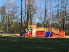
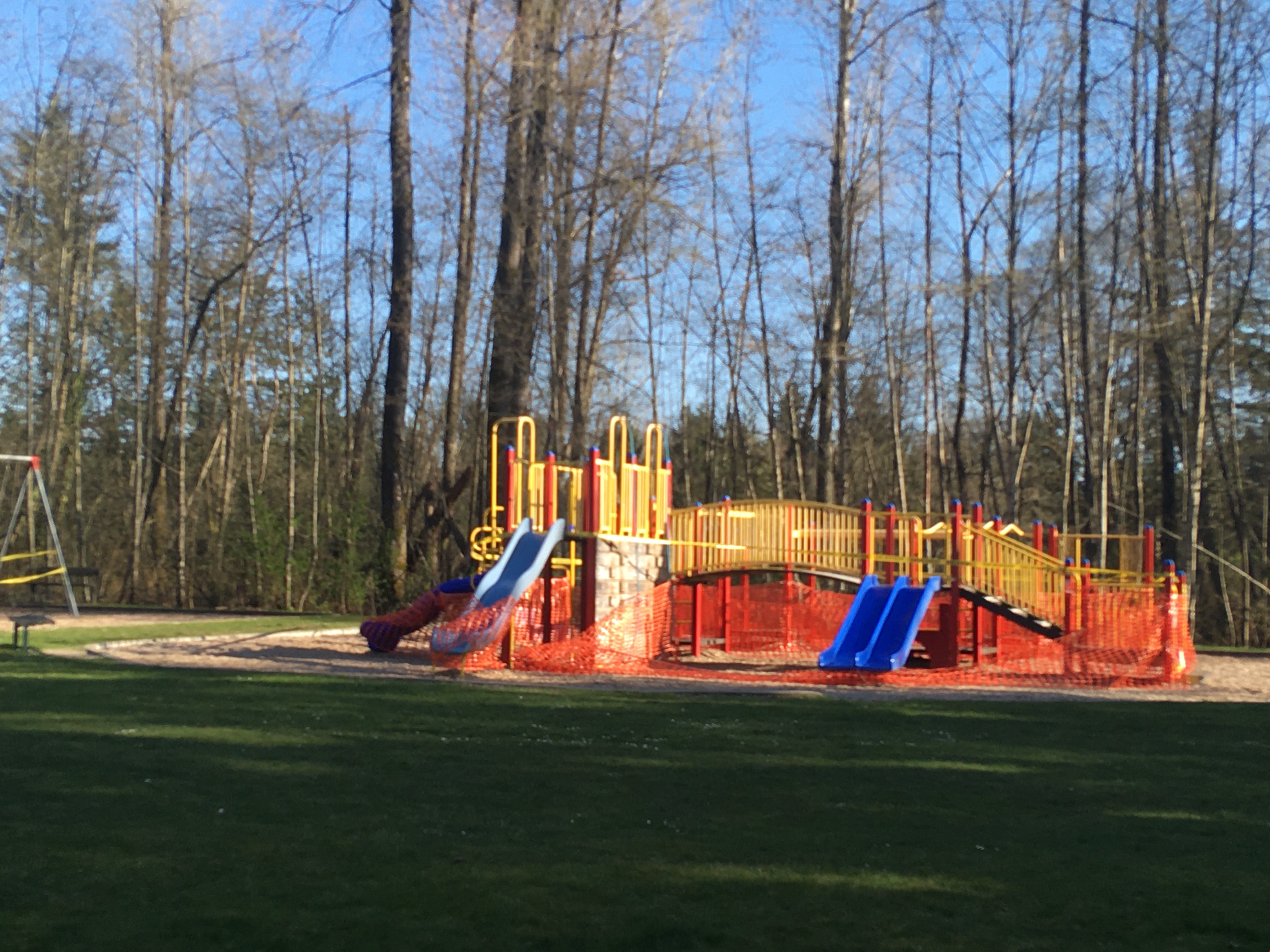
Playground in Squint Lake Park
https://search.heritageburnaby.ca/link/museumdescription14736
- Repository
- Burnaby Village Museum
- Date
- 9 Apr. 2020
- Collection/Fonds
- Burnaby Village Museum COVID-19 collection
- Description Level
- Item
- Physical Description
- 1 photograph (jpg) : col. ; 72 dpi.
- Scope and Content
- Photograph of the Squint Lake Park playground. The playground equipment is surrounded by orange construction fencing to prevent childlren from playing on it. The playground was closed down by the City of Burnaby in the spring of 2020 due to the COVID-19 pandemic and public health orders.
- Repository
- Burnaby Village Museum
- Collection/Fonds
- Burnaby Village Museum COVID-19 collection
- Description Level
- Item
- Physical Description
- 1 photograph (jpg) : col. ; 72 dpi.
- Scope and Content
- Photograph of the Squint Lake Park playground. The playground equipment is surrounded by orange construction fencing to prevent childlren from playing on it. The playground was closed down by the City of Burnaby in the spring of 2020 due to the COVID-19 pandemic and public health orders.
- History
- Tristan Johnson took photos around Burnaby because as a parent of two elementary school aged children during the COVID-19 pandemic, one of the most notable things about COVID-19 during Spring 2020 was the closure of playgrounds and the playgrounds being taped up.
- Accession Code
- BV020.21.1
- Access Restriction
- No restrictions
- Reproduction Restriction
- No known restrictions
- Date
- 9 Apr. 2020
- Media Type
- Photograph
- Planning Study Area
- Sperling-Broadway Area
- Photographer
- Johnson, Tristan
- Notes
- Title based on contents of photograph
Images
South Burnaby Garden Club fonds
https://search.heritageburnaby.ca/link/archivedescription97232
- Repository
- City of Burnaby Archives
- Date
- 1983-2012
- Collection/Fonds
- South Burnaby Garden Club fonds
- Description Level
- Fonds
- Physical Description
- 11.2 cm of textual records; 180 col. prints; 119 col. neg.
- Scope and Content
- Fonds consists of photographs and documents created and collected by the South Burnaby Garden Club, detailing Club activities including the Fall Fair.
- Repository
- City of Burnaby Archives
- Date
- 1983-2012
- Collection/Fonds
- South Burnaby Garden Club fonds
- Physical Description
- 11.2 cm of textual records; 180 col. prints; 119 col. neg.
- Description Level
- Fonds
- Accession Number
- 2008-17
- 2014-14
- Scope and Content
- Fonds consists of photographs and documents created and collected by the South Burnaby Garden Club, detailing Club activities including the Fall Fair.
- History
- The South Burnaby Garden Club was formed in 1901 when a group of Central Park residents met to form a Farmers’ Institute. They leased 17 acres of Central Park from the Provincial Government and with the support of government grants constructed a two-story building on the property. The building was constructed in time for the first annual Fall Fair in September 1901. In 1903, the Institute amalgamated with the South Vancouver and Burnaby Agricultural Society to become the Central Park Agricultural Association & Farmers Institute. In 1907, the membership doubled to 520 members. Increasing urbanization and the First World War saw the last exhibition in 1919, and then lease on the building expired in 1921. The Society continued to meet and hold small exhibitions in rented halls under the South Burnaby Horticultural Association name. After several name changes, the association became the South Burnaby Garden Club in 1958 and continues to this day.
- Media Type
- Photograph
- Textual Record
- Notes
- Photo catalogue 489
- MSS124
- MSS182

3955 Moscrop Street
https://search.heritageburnaby.ca/link/archivedescription98654
- Repository
- City of Burnaby Archives
- Date
- 2021
- Collection/Fonds
- Disappearing Burnaby collection
- Description Level
- Item
- Physical Description
- 1 photograph (jpeg) : col.
- Scope and Content
- Photograph of the exterior of a house located at 3955 Moscrop Street. The house was constructed in 1954. The photograph depicts the house at night, with the house's porch light on, and a car is in the driveway in front of the house.
- Repository
- City of Burnaby Archives
- Date
- 2021
- Collection/Fonds
- Disappearing Burnaby collection
- Physical Description
- 1 photograph (jpeg) : col.
- Description Level
- Item
- Record No.
- 634-001
- Access Restriction
- No restrictions
- Reproduction Restriction
- No restrictions
- Accession Number
- 2022-14
- Scope and Content
- Photograph of the exterior of a house located at 3955 Moscrop Street. The house was constructed in 1954. The photograph depicts the house at night, with the house's porch light on, and a car is in the driveway in front of the house.
- Media Type
- Photograph
- Photographer
- Cheung, Nakita
- Notes
- Title taken from the associated blog post
- Associated blog post: https://disappearingburnaby.wordpress.com/2022/02/24/moscrop-house/
- Geographic Access
- Moscrop Street
- Street Address
- 3955 Moscrop Street
- Historic Neighbourhood
- Broadview (Historic Neighbourhood)
- Planning Study Area
- Cascade-Schou Area
Images


5130 Irving Street
https://search.heritageburnaby.ca/link/archivedescription98671
- Repository
- City of Burnaby Archives
- Date
- 2022
- Collection/Fonds
- Disappearing Burnaby collection
- Description Level
- Item
- Physical Description
- 1 photograph (jpeg) : col.
- Scope and Content
- Photograph of the front steps and the entrance of a three-storey apartment building located at 5130 Irving Street. The photograph depicts the building at night, with the lobby and some of the apartments' windows illuminated from inside. The building was constructed in 1971.
- Repository
- City of Burnaby Archives
- Date
- 2022
- Collection/Fonds
- Disappearing Burnaby collection
- Physical Description
- 1 photograph (jpeg) : col.
- Description Level
- Item
- Record No.
- 634-018
- Access Restriction
- No restrictions
- Reproduction Restriction
- No restrictions
- Accession Number
- 2022-14
- Scope and Content
- Photograph of the front steps and the entrance of a three-storey apartment building located at 5130 Irving Street. The photograph depicts the building at night, with the lobby and some of the apartments' windows illuminated from inside. The building was constructed in 1971.
- Media Type
- Photograph
- Photographer
- Cheung, Nakita
- Notes
- Title taken from the associated blog post
- Associated blog post: https://disappearingburnaby.wordpress.com/2022/05/04/e-just-e/
- Geographic Access
- Irving Street
- Street Address
- 5130 Irving Street
- Historic Neighbourhood
- Central Park (Historic Neighbourhood)
- Planning Study Area
- Marlborough Area
Images


5130 Irving Street lobby
https://search.heritageburnaby.ca/link/archivedescription98672
- Repository
- City of Burnaby Archives
- Date
- 2022
- Collection/Fonds
- Disappearing Burnaby collection
- Description Level
- Item
- Physical Description
- 1 photograph (jpeg) : col.
- Scope and Content
- Photograph of the entrance of an apartment building located at 5130 Irving Street. The building was constructed in 1971. The photograph depicts the entrance and the lobby from the exterior at night. The lobby is illuminated and a crest featuring an "E" is on the entrance window.
- Repository
- City of Burnaby Archives
- Date
- 2022
- Collection/Fonds
- Disappearing Burnaby collection
- Physical Description
- 1 photograph (jpeg) : col.
- Description Level
- Item
- Record No.
- 634-019
- Access Restriction
- No restrictions
- Reproduction Restriction
- No restrictions
- Accession Number
- 2022-14
- Scope and Content
- Photograph of the entrance of an apartment building located at 5130 Irving Street. The building was constructed in 1971. The photograph depicts the entrance and the lobby from the exterior at night. The lobby is illuminated and a crest featuring an "E" is on the entrance window.
- Media Type
- Photograph
- Photographer
- Cheung, Nakita
- Notes
- Title taken from the associated blog post
- Associated blog post: https://disappearingburnaby.wordpress.com/2022/05/04/e-just-e/
- Geographic Access
- Irving Street
- Street Address
- 5130 Irving Street
- Historic Neighbourhood
- Central Park (Historic Neighbourhood)
- Planning Study Area
- Marlborough Area
Images


5990 Irmin Street
https://search.heritageburnaby.ca/link/archivedescription98685
- Repository
- City of Burnaby Archives
- Date
- 2022
- Collection/Fonds
- Disappearing Burnaby collection
- Description Level
- Item
- Physical Description
- 1 photograph (jpeg) : col.
- Scope and Content
- Photograph of a multi-storey house located at 5990 Irmin Street. The photograph depicts of the exterior of the house at dusk; a light is on in one of the house's rooms and a vehicle is parked in the house's driveway next to a portable garage. A "For Sale" sign on the edge of the property reads: "Fu…
- Repository
- City of Burnaby Archives
- Date
- 2022
- Collection/Fonds
- Disappearing Burnaby collection
- Physical Description
- 1 photograph (jpeg) : col.
- Description Level
- Item
- Record No.
- 634-032
- Access Restriction
- No restrictions
- Reproduction Restriction
- No restrictions
- Accession Number
- 2022-14
- Scope and Content
- Photograph of a multi-storey house located at 5990 Irmin Street. The photograph depicts of the exterior of the house at dusk; a light is on in one of the house's rooms and a vehicle is parked in the house's driveway next to a portable garage. A "For Sale" sign on the edge of the property reads: "Future Development Land." Another house is visible in the background. The house was constructed in 1923 and is nearby to 7530 Buller Avenue.
- Media Type
- Photograph
- Photographer
- Cheung, Nakita
- Notes
- Title taken from the associated blog post
- Associated blog post: https://disappearingburnaby.wordpress.com/2022/06/30/william-esther-burdick-residence/
- Geographic Access
- Irmin Street
- Street Address
- 5990 Irmin Street
- Historic Neighbourhood
- Alta Vista (Historic Neighbourhood)
- Planning Study Area
- Clinton-Glenwood Area
Images


6280 Marlborough Avenue
https://search.heritageburnaby.ca/link/archivedescription98673
- Repository
- City of Burnaby Archives
- Date
- 2022
- Collection/Fonds
- Disappearing Burnaby collection
- Description Level
- Item
- Physical Description
- 1 photograph (jpeg) : col.
- Scope and Content
- Photograph of the front steps and entry to a three-storey apartment building, located at 6280 Marlborough Avenue. The photograph depicts the building at night and shows the brick building's details, including its lion statues and busts along the stair railings and the curved arches in front of the …
- Repository
- City of Burnaby Archives
- Date
- 2022
- Collection/Fonds
- Disappearing Burnaby collection
- Physical Description
- 1 photograph (jpeg) : col.
- Description Level
- Item
- Record No.
- 634-020
- Access Restriction
- No restrictions
- Reproduction Restriction
- No restrictions
- Accession Number
- 2022-14
- Scope and Content
- Photograph of the front steps and entry to a three-storey apartment building, located at 6280 Marlborough Avenue. The photograph depicts the building at night and shows the brick building's details, including its lion statues and busts along the stair railings and the curved arches in front of the front windows and door. The building was constructed in 1973.
- Media Type
- Photograph
- Photographer
- Cheung, Nakita
- Notes
- Title taken from the associated blog post
- Associated blog post: https://disappearingburnaby.wordpress.com/2022/05/12/marlborough-ave/
- Geographic Access
- Marlborough Avenue
- Street Address
- 6280 Marlborough Avenue
- Historic Neighbourhood
- Central Park (Historic Neighbourhood)
- Planning Study Area
- Marlborough Area
Images


6410 Denbigh Avenue
https://search.heritageburnaby.ca/link/archivedescription98667
- Repository
- City of Burnaby Archives
- Date
- 2022
- Collection/Fonds
- Disappearing Burnaby collection
- Description Level
- Item
- Physical Description
- 1 photograph (jpeg) : col.
- Scope and Content
- Photograph of the exterior of a single-storey house located at 6410 Denbigh Avenue, taken from across the street at dusk. The house was constructed in 1949. Lights illuminate the front porch and the interior of one of the house's windows and there is a small amount of snow on the lawn in front of t…
- Repository
- City of Burnaby Archives
- Date
- 2022
- Collection/Fonds
- Disappearing Burnaby collection
- Physical Description
- 1 photograph (jpeg) : col.
- Description Level
- Item
- Record No.
- 634-014
- Access Restriction
- No restrictions
- Reproduction Restriction
- No restrictions
- Accession Number
- 2022-14
- Scope and Content
- Photograph of the exterior of a single-storey house located at 6410 Denbigh Avenue, taken from across the street at dusk. The house was constructed in 1949. Lights illuminate the front porch and the interior of one of the house's windows and there is a small amount of snow on the lawn in front of the house.
- Media Type
- Photograph
- Photographer
- Cheung, Nakita
- Notes
- Title taken from the associated blog post
- Associated blog post: https://disappearingburnaby.wordpress.com/2022/05/15/denbigh-ave/
- Geographic Access
- Denbigh Avenue
- Street Address
- 6410 Denbigh Avenue
- Historic Neighbourhood
- Central Park (Historic Neighbourhood)
- Planning Study Area
- Windsor Area
Images


6508 Silver Avenue
https://search.heritageburnaby.ca/link/archivedescription98678
- Repository
- City of Burnaby Archives
- Date
- 2022
- Collection/Fonds
- Disappearing Burnaby collection
- Description Level
- Item
- Physical Description
- 1 photograph (jpeg) : col.
- Scope and Content
- Photograph of the corner and side of the exterior of a concrete low-rise apartment building located at 6508 Silver Avenue. The photograph depicts the building at dusk. Some of the apartment windows are lit up from inside, and plant pots are lined up along the third-floor balcony. A chain link fence…
- Repository
- City of Burnaby Archives
- Date
- 2022
- Collection/Fonds
- Disappearing Burnaby collection
- Physical Description
- 1 photograph (jpeg) : col.
- Description Level
- Item
- Record No.
- 634-025
- Access Restriction
- No restrictions
- Reproduction Restriction
- No restrictions
- Accession Number
- 2022-14
- Scope and Content
- Photograph of the corner and side of the exterior of a concrete low-rise apartment building located at 6508 Silver Avenue. The photograph depicts the building at dusk. Some of the apartment windows are lit up from inside, and plant pots are lined up along the third-floor balcony. A chain link fence surrounds the backyard. The building was constructed in 1966.
- Media Type
- Photograph
- Photographer
- Cheung, Nakita
- Notes
- Title taken from the associated blog post
- Associated blog post: https://disappearingburnaby.wordpress.com/2022/06/30/brutalist/
- Geographic Access
- Silver Avenue
- Street Address
- 6508 Silver Avenue
- Historic Neighbourhood
- Central Park (Historic Neighbourhood)
- Planning Study Area
- Maywood Area
Images


6615 Telford Avenue
https://search.heritageburnaby.ca/link/archivedescription98674
- Repository
- City of Burnaby Archives
- Date
- 2022
- Collection/Fonds
- Disappearing Burnaby collection
- Description Level
- Item
- Physical Description
- 1 photograph (jpeg) : col.
- Scope and Content
- Photograph of the entrance, including the front steps and ramp, to a low-rise apartment building located at 6615 Telford Avenue. The building was constructed in 1964. The photograph depicts the building at night, and trees and bushes partially obscure the entrance. The building's lobby is illuminat…
- Repository
- City of Burnaby Archives
- Date
- 2022
- Collection/Fonds
- Disappearing Burnaby collection
- Physical Description
- 1 photograph (jpeg) : col.
- Description Level
- Item
- Record No.
- 634-021
- Access Restriction
- No restrictions
- Reproduction Restriction
- No restrictions
- Accession Number
- 2022-14
- Scope and Content
- Photograph of the entrance, including the front steps and ramp, to a low-rise apartment building located at 6615 Telford Avenue. The building was constructed in 1964. The photograph depicts the building at night, and trees and bushes partially obscure the entrance. The building's lobby is illuminated and the apartments' mailboxes are visible through the window.
- Media Type
- Photograph
- Photographer
- Cheung, Nakita
- Notes
- Title taken from the associated blog post
- Associated blog post: https://disappearingburnaby.wordpress.com/2022/06/09/martello-group/
- Geographic Access
- Telford Avenue
- Street Address
- 6615 Telford Avenue
- Historic Neighbourhood
- Central Park (Historic Neighbourhood)
- Planning Study Area
- Maywood Area
Images


6692 Dow Avenue
https://search.heritageburnaby.ca/link/archivedescription98662
- Repository
- City of Burnaby Archives
- Date
- 2022
- Collection/Fonds
- Disappearing Burnaby collection
- Description Level
- Item
- Physical Description
- 1 photograph (jpeg) : col.
- Scope and Content
- Photograph of the exterior of a two-storey apartment building located at 6692 Dow Avenue. The photograph depicts the building from across the street at night; the lobby and some of the apartment windows are lit up, with a bunch of balloons in one window, and a car is parked on the street in front o…
- Repository
- City of Burnaby Archives
- Date
- 2022
- Collection/Fonds
- Disappearing Burnaby collection
- Physical Description
- 1 photograph (jpeg) : col.
- Description Level
- Item
- Record No.
- 634-009
- Access Restriction
- No restrictions
- Reproduction Restriction
- No restrictions
- Accession Number
- 2022-14
- Scope and Content
- Photograph of the exterior of a two-storey apartment building located at 6692 Dow Avenue. The photograph depicts the building from across the street at night; the lobby and some of the apartment windows are lit up, with a bunch of balloons in one window, and a car is parked on the street in front of the building. The building was constructed in 1959.
- Media Type
- Photograph
- Photographer
- Cheung, Nakita
- Notes
- Title taken from the associated blog post
- Associated blog post: https://disappearingburnaby.wordpress.com/2022/03/01/dow-ave/
- Geographic Access
- Dow Avenue
- Street Address
- 6692 Dow Avenue
- Historic Neighbourhood
- Central Park (Historic Neighbourhood)
- Planning Study Area
- Maywood Area
Images


6700 Dow Avenue
https://search.heritageburnaby.ca/link/archivedescription98663
- Repository
- City of Burnaby Archives
- Date
- 2022
- Collection/Fonds
- Disappearing Burnaby collection
- Description Level
- Item
- Physical Description
- 1 photograph (jpeg) : col.
- Scope and Content
- Photograph of the entrance to an apartment building located at 6700 Dow Avenue. The photograph depicts the building at night; the lobby and stairs are illuminated by exterior and interior lights. The building was constructed in 1968.
- Repository
- City of Burnaby Archives
- Date
- 2022
- Collection/Fonds
- Disappearing Burnaby collection
- Physical Description
- 1 photograph (jpeg) : col.
- Description Level
- Item
- Record No.
- 634-010
- Access Restriction
- No restrictions
- Reproduction Restriction
- No restrictions
- Accession Number
- 2022-14
- Scope and Content
- Photograph of the entrance to an apartment building located at 6700 Dow Avenue. The photograph depicts the building at night; the lobby and stairs are illuminated by exterior and interior lights. The building was constructed in 1968.
- Media Type
- Photograph
- Photographer
- Cheung, Nakita
- Notes
- Title taken from the associated blog post
- Associated blog post: https://disappearingburnaby.wordpress.com/2022/03/29/no-pes/
- Geographic Access
- Dow Avenue
- Street Address
- 6700 Dow Avenue
- Historic Neighbourhood
- Central Park (Historic Neighbourhood)
- Planning Study Area
- Maywood Area
Images


7530 Buller Avenue
https://search.heritageburnaby.ca/link/archivedescription98686
- Repository
- City of Burnaby Archives
- Date
- 2022
- Collection/Fonds
- Disappearing Burnaby collection
- Description Level
- Item
- Physical Description
- 1 photograph (jpeg) : col.
- Scope and Content
- Photograph of the exterior of a two-storey house located at 7530 Buller Avenue. The photograph depicts the house at dusk; the house stands behind a wooden fence and is surrounded by trees. The house was constructed in 1924 and was formerly known as "Ryverbrae," the William & Esther Burdick Residenc…
- Repository
- City of Burnaby Archives
- Date
- 2022
- Collection/Fonds
- Disappearing Burnaby collection
- Physical Description
- 1 photograph (jpeg) : col.
- Description Level
- Item
- Record No.
- 634-033
- Access Restriction
- No restrictions
- Reproduction Restriction
- No restrictions
- Accession Number
- 2022-14
- Scope and Content
- Photograph of the exterior of a two-storey house located at 7530 Buller Avenue. The photograph depicts the house at dusk; the house stands behind a wooden fence and is surrounded by trees. The house was constructed in 1924 and was formerly known as "Ryverbrae," the William & Esther Burdick Residence.
- Media Type
- Photograph
- Photographer
- Cheung, Nakita
- Notes
- Title taken from the associated blog post
- Associated blog post: https://disappearingburnaby.wordpress.com/2022/06/30/william-esther-burdick-residence/
- Geographic Access
- Buller Avenue
- Street Address
- 7530 Buller Avenue
- Historic Neighbourhood
- Alta Vista (Historic Neighbourhood)
- Planning Study Area
- Clinton-Glenwood Area
Images


Canadian Food Market
https://search.heritageburnaby.ca/link/archivedescription98666
- Repository
- City of Burnaby Archives
- Date
- 2022
- Collection/Fonds
- Disappearing Burnaby collection
- Description Level
- Item
- Physical Description
- 1 photograph (jpeg) : col.
- Scope and Content
- Photograph of the exterior of the Canadian Food Market, taken from across Imperial Street at night. The grocery store is located at 4378 Imperial Street and the building was constructed in 1962. A large display of plants and flowers stands in front of the store and is illuminated by bright lights.
- Repository
- City of Burnaby Archives
- Date
- 2022
- Collection/Fonds
- Disappearing Burnaby collection
- Physical Description
- 1 photograph (jpeg) : col.
- Description Level
- Item
- Record No.
- 634-013
- Access Restriction
- No restrictions
- Reproduction Restriction
- No restrictions
- Accession Number
- 2022-14
- Scope and Content
- Photograph of the exterior of the Canadian Food Market, taken from across Imperial Street at night. The grocery store is located at 4378 Imperial Street and the building was constructed in 1962. A large display of plants and flowers stands in front of the store and is illuminated by bright lights.
- Media Type
- Photograph
- Photographer
- Cheung, Nakita
- Notes
- Title taken from the associated blog post
- Associated blog post: https://disappearingburnaby.wordpress.com/2022/02/20/imperial-manor-2/
- Geographic Access
- Imperial Street
- Street Address
- 4378 Imperial Street
- Historic Neighbourhood
- Central Park (Historic Neighbourhood)
- Planning Study Area
- Sussex-Nelson Area
Images


Charmwood Apartments
https://search.heritageburnaby.ca/link/archivedescription98661
- Repository
- City of Burnaby Archives
- Date
- 2022
- Collection/Fonds
- Disappearing Burnaby collection
- Description Level
- Item
- Physical Description
- 1 photograph (jpeg) : col.
- Scope and Content
- Photograph of the entrance to Charmwood Apartments, a low-rise apartment building located at 6558 Sussex Avenue. The building was constructed in 1964. The photograph depicts the building at night; building's stairwell and lobby are visible from the lights shining through the windows.
- Repository
- City of Burnaby Archives
- Date
- 2022
- Collection/Fonds
- Disappearing Burnaby collection
- Physical Description
- 1 photograph (jpeg) : col.
- Description Level
- Item
- Record No.
- 634-008
- Access Restriction
- No restrictions
- Reproduction Restriction
- No restrictions
- Accession Number
- 2022-14
- Scope and Content
- Photograph of the entrance to Charmwood Apartments, a low-rise apartment building located at 6558 Sussex Avenue. The building was constructed in 1964. The photograph depicts the building at night; building's stairwell and lobby are visible from the lights shining through the windows.
- Media Type
- Photograph
- Photographer
- Cheung, Nakita
- Notes
- Title taken from the associated blog post
- Associated blog post: https://disappearingburnaby.wordpress.com/2022/03/12/charmwood-apts/
- Geographic Access
- Sussex Avenue
- Street Address
- 6558 Sussex Avenue
- Historic Neighbourhood
- Central Park (Historic Neighbourhood)
- Planning Study Area
- Maywood Area
Images

Community Heritage Commission subseries
https://search.heritageburnaby.ca/link/archivedescription96378
- Repository
- City of Burnaby Archives
- Date
- 1989-2012
- Collection/Fonds
- City Council and Office of the City Clerk fonds
- Description Level
- Subseries
- Physical Description
- 46 folders of textual records + 2 photographs + 1 portrait
- Scope and Content
- Subseries consists of committee records for the Community Heritage Commission including agendas, minutes, correspondence, committee reports, and heritage sites.
- Repository
- City of Burnaby Archives
- Date
- 1989-2012
- Collection/Fonds
- City Council and Office of the City Clerk fonds
- Series
- Council Committee series
- Subseries
- Community Heritage Commission subseries
- Physical Description
- 46 folders of textual records + 2 photographs + 1 portrait
- Description Level
- Subseries
- Scope and Content
- Subseries consists of committee records for the Community Heritage Commission including agendas, minutes, correspondence, committee reports, and heritage sites.
- History
- The Community Heritage Commission was established December of 1994. This committee was formerly known as the Heritage Advisory Committee. The Community Heritage Commission supports efforts to increase public awareness of and provide management for constructed and natural heritage in the City of Burnaby.
- Media Type
- Textual Record
- Photograph
- Graphic Material