Narrow Results By
Blue flowers
https://search.heritageburnaby.ca/link/archivedescription63105
- Repository
- City of Burnaby Archives
- Date
- [before 1976]
- Collection/Fonds
- Burnaby Historical Society fonds
- Description Level
- Item
- Physical Description
- 1 painting : watercolour ; 38.5 x 26 cm
- Scope and Content
- Item is a watercolour painting by Leila Orman of cut blue flowers arranged in a flower pot.
- Repository
- City of Burnaby Archives
- Date
- [before 1976]
- Collection/Fonds
- Burnaby Historical Society fonds
- Subseries
- Leila Orman subseries
- Physical Description
- 1 painting : watercolour ; 38.5 x 26 cm
- Description Level
- Item
- Record No.
- MSS104-020
- Accession Number
- BHS2007-04
- Scope and Content
- Item is a watercolour painting by Leila Orman of cut blue flowers arranged in a flower pot.
- Media Type
- Graphic Material
- Notes
- Title based on contents of painting
Boundary Plan - Location for Burnaby Council of the West Boundary of Lots 161 and 175 Group One
https://search.heritageburnaby.ca/link/archivedescription8042
- Repository
- City of Burnaby Archives
- Date
- [1909]
- Collection/Fonds
- City Council and Office of the City Clerk fonds
- Description Level
- Item
- Physical Description
- Cartographic material
- Scope and Content
- Item consists of one plan on waxed linen with colour ink noting the western boundary of District Lots 161 and 175.
- Repository
- City of Burnaby Archives
- Date
- [1909]
- Collection/Fonds
- City Council and Office of the City Clerk fonds
- Physical Description
- Cartographic material
- Description Level
- Item
- Record No.
- 10997
- Accession Number
- 2001-02
- Scope and Content
- Item consists of one plan on waxed linen with colour ink noting the western boundary of District Lots 161 and 175.
- Media Type
- Cartographic Material
- Notes
- Located in map case.
The City of Vancouver B.C.
https://search.heritageburnaby.ca/link/archivedescription66103
- Repository
- City of Burnaby Archives
- Date
- [between 1916 and 1929]
- Collection/Fonds
- Burnaby Historical Society fonds
- Description Level
- Item
- Physical Description
- 1 map : b&w ink on paper ; 56 x 107 cm folded to 21 x 12.5 cm
- Scope and Content
- Item is a map of "[the] City of Vancouver B.C" drawn prior to amalgamation of Point Grey and South Vancouver with the City of Vancouver.
- Repository
- City of Burnaby Archives
- Date
- [between 1916 and 1929]
- Collection/Fonds
- Burnaby Historical Society fonds
- Subseries
- Ephemera subseries
- Physical Description
- 1 map : b&w ink on paper ; 56 x 107 cm folded to 21 x 12.5 cm
- Material Details
- Map has a blue construction paper cover
- Scale : 1 inch = 1000 feet
- Description Level
- Item
- Record No.
- 42707
- Accession Number
- BHS2007-04
- Scope and Content
- Item is a map of "[the] City of Vancouver B.C" drawn prior to amalgamation of Point Grey and South Vancouver with the City of Vancouver.
- Media Type
- Cartographic Material
- Notes
- Transcribed title
Corner of Granville & Georgia Sts. 1889
https://search.heritageburnaby.ca/link/archivedescription65741
- Repository
- City of Burnaby Archives
- Date
- 1889
- Collection/Fonds
- Burnaby Historical Society fonds
- Description Level
- Item
- Physical Description
- 1 print : watercolour reproduction ; 9 x 20 cm [sight] in frame 16.5 x 27 cm
- Scope and Content
- Item is a framed watercolour reproduction of the corner of Granville and Georgia Streets in downtown Vancouver, British Columbia in 1889.
- Repository
- City of Burnaby Archives
- Date
- 1889
- Collection/Fonds
- Burnaby Historical Society fonds
- Subseries
- Anne Sievenpiper subseries
- Physical Description
- 1 print : watercolour reproduction ; 9 x 20 cm [sight] in frame 16.5 x 27 cm
- Description Level
- Item
- Record No.
- 42663
- Accession Number
- BHS2001-02
- Scope and Content
- Item is a framed watercolour reproduction of the corner of Granville and Georgia Streets in downtown Vancouver, British Columbia in 1889.
- Media Type
- Graphic Material
- Responsibility
- Original watercolour by George Mercer
- Notes
- Transcribed title
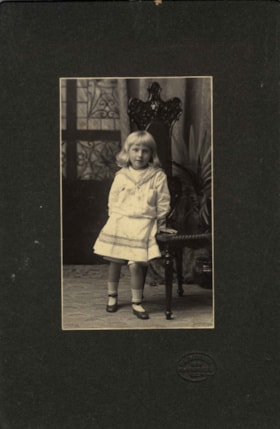
Kitty Hill
https://search.heritageburnaby.ca/link/archivedescription66567
- Repository
- City of Burnaby Archives
- Date
- 1904
- Collection/Fonds
- Peers Family and Hill Family fonds
- Description Level
- Item
- Physical Description
- 1 photograph : b&w + 1 watercolour painting
- Scope and Content
- Photograph is a portrait of Kitty Hill, posing next to a high-back chair. Accompanying the photograph is a watercolour painting that was based on this photograph, done on a linen backing.
- Repository
- City of Burnaby Archives
- Date
- 1904
- Collection/Fonds
- Peers Family and Hill Family fonds
- Physical Description
- 1 photograph : b&w + 1 watercolour painting
- Description Level
- Item
- Record No.
- 477-1181
- Access Restriction
- No restrictions
- Reproduction Restriction
- No known restrictions
- Accession Number
- 2007-12
- Scope and Content
- Photograph is a portrait of Kitty Hill, posing next to a high-back chair. Accompanying the photograph is a watercolour painting that was based on this photograph, done on a linen backing.
- Media Type
- Photograph
- Graphic Material
- Notes
- Title based on contents of photograph
Images

Map of New Westminster District
https://search.heritageburnaby.ca/link/archivedescription24491
- Repository
- City of Burnaby Archives
- Date
- 1913
- Collection/Fonds
- City Council and Office of the City Clerk fonds
- Description Level
- Item
- Physical Description
- Cartographic material
- Scope and Content
- Item consists of one canvas map entitled "1913 District of New Westminster" and depicting the area bordered on the east by Hope, west to the Georgia Strait, north to North Vancouver and south to the United States border.
- Repository
- City of Burnaby Archives
- Date
- 1913
- Collection/Fonds
- City Council and Office of the City Clerk fonds
- Physical Description
- Cartographic material
- Description Level
- Item
- Record No.
- 27497
- Access Restriction
- Open access
- Accession Number
- 2006-09
- Scope and Content
- Item consists of one canvas map entitled "1913 District of New Westminster" and depicting the area bordered on the east by Hope, west to the Georgia Strait, north to North Vancouver and south to the United States border.
- Media Type
- Cartographic Material
North Burnaby Auxiliary minute book
https://search.heritageburnaby.ca/link/archivedescription65050
- Repository
- City of Burnaby Archives
- Date
- 1913-1924
- Collection/Fonds
- Victorian Order of Nurses fonds
- Description Level
- Item
- Physical Description
- 1 notebook (hardcover) + 1 map
- Scope and Content
- Item is a Victorian Order of Nurses (VON) North Burnaby Auxiliary minute book. Included in the minute book is a white linen early street map depicting East Burnaby and New Westminster.
- Repository
- City of Burnaby Archives
- Date
- 1913-1924
- Collection/Fonds
- Victorian Order of Nurses fonds
- Physical Description
- 1 notebook (hardcover) + 1 map
- Description Level
- Item
- Record No.
- MSS021-004
- Accession Number
- 2010-09
- Scope and Content
- Item is a Victorian Order of Nurses (VON) North Burnaby Auxiliary minute book. Included in the minute book is a white linen early street map depicting East Burnaby and New Westminster.
- Media Type
- Textual Record
- Cartographic Material
Plan Shewing [sic] Position of New Wagon Road through DL's 214 and 213
https://search.heritageburnaby.ca/link/archivedescription8037
- Repository
- City of Burnaby Archives
- Date
- 1908
- Collection/Fonds
- City Council and Office of the City Clerk fonds
- Description Level
- Item
- Physical Description
- 1 map
- Scope and Content
- White linen plan showing DL's 212, 213, 214, and 215 with Burrard Inlet to the north and the proposed road done in red.
- Repository
- City of Burnaby Archives
- Date
- 1908
- Collection/Fonds
- City Council and Office of the City Clerk fonds
- Physical Description
- 1 map
- Description Level
- Item
- Record No.
- 10992
- Accession Number
- 2001-02
- Scope and Content
- White linen plan showing DL's 212, 213, 214, and 215 with Burrard Inlet to the north and the proposed road done in red.
- Media Type
- Cartographic Material
- Notes
- Located in map case.
Plan Showing Proposed Road DL 212
https://search.heritageburnaby.ca/link/archivedescription8036
- Repository
- City of Burnaby Archives
- Date
- [191-?]
- Collection/Fonds
- City Council and Office of the City Clerk fonds
- Description Level
- Item
- Physical Description
- 1 map
- Scope and Content
- White linen plan with Burrard Inlet to the north and Barnet Road to the South. A proposed crossing for the Canadian Pacific Railway is outlined in red and the Bestwood Shingle Mill and Nichol's Chemical operation are identified in black.
- Repository
- City of Burnaby Archives
- Date
- [191-?]
- Collection/Fonds
- City Council and Office of the City Clerk fonds
- Physical Description
- 1 map
- Description Level
- Item
- Record No.
- 10990
- Accession Number
- 2001-02
- Scope and Content
- White linen plan with Burrard Inlet to the north and Barnet Road to the South. A proposed crossing for the Canadian Pacific Railway is outlined in red and the Bestwood Shingle Mill and Nichol's Chemical operation are identified in black.
- Media Type
- Cartographic Material
- Notes
- Located in map case.
Survey - Roberts Road and Power House Road
https://search.heritageburnaby.ca/link/archivedescription8038
- Repository
- City of Burnaby Archives
- Date
- [191-?]
- Collection/Fonds
- City Council and Office of the City Clerk fonds
- Description Level
- Item
- Physical Description
- 1 map
- Scope and Content
- One white linen plan with Vancouver Road to the north and North Arm Road to the south.
- Repository
- City of Burnaby Archives
- Date
- [191-?]
- Collection/Fonds
- City Council and Office of the City Clerk fonds
- Physical Description
- 1 map
- Description Level
- Item
- Record No.
- 10993
- Accession Number
- 2001-02
- Scope and Content
- One white linen plan with Vancouver Road to the north and North Arm Road to the south.
- Media Type
- Cartographic Material
- Notes
- Located in map case.