More like 'Real Estate - Surveyor's office building'
Narrow Results By
Decade
- 2020s 24
- 2010s 34
- 2000s 276
- 1990s 217
- 1980s 130
- 1970s 207
- 1960s 209
- 1950s 185
- 1940s 307
- 1930s 134
- 1920s 199
- 1910s
- 1900s 106
- 1890s 26
- 1880s 4
- 1870s 2
- 1860s 2
- 1850s 1
- 1840s
- 1830s 1
- 1820s 1
- 1810s 1
- 1800s 1
- 1790s 1
- 1780s 1
- 1770s 1
- 1760s 1
- 1750s 1
- 1740s 1
- 1730s 1
- 1720s 1
- 1710s 1
- 1700s 1
- 1690s 1
- 1680s 1
- 1670s 1
- 1660s 1
- 1650s 1
- 1640s 1
- 1630s 1
- 1620s 1
- 1610s 1
- 1600s 1
Subject
- Agricultural Tools and Equipment 1
- Agricultural Tools and Equipment - Plows 2
- Animals - Cows 1
- Animals - Dogs 3
- Animals - Horses 1
- Armament 6
- Armament - Munitions 5
- Buildings - Civic - Hospitals 1
- Buildings - Commercial - Grocery Stores 5
- Buildings - Commercial - Stores 2
- Buildings - Industrial 5
- Buildings - Industrial - Factories 3
![Bird's eye view of New Westminster, Burnaby and Vancouver, [ca. 1911] thumbnail](/media/hpo/_Data/_BVM_Cartographic_Material/1983/1983_0012_0001_002%20Web.jpg?width=280)
Bird's eye view of New Westminster, Burnaby and Vancouver
https://search.heritageburnaby.ca/link/museumdescription8199
- Repository
- Burnaby Village Museum
- Date
- [ca. 1911]
- Collection/Fonds
- Burnaby Village Museum Map collection
- Description Level
- Item
- Physical Description
- 1 map : hand painted ; 65.5 x 99 cm
- Scope and Content
- An untitled monochromatic grayscale map of a developer's bird's eye view looking north west from Burnaby Mountain. View includes Burnaby, New Westminster, Vancouver with the North shore in the distance. Burnaby neighbourhood subdivisions of "Burnaby Heights" and "Buena Vista" are featured near the…
- Repository
- Burnaby Village Museum
- Collection/Fonds
- Burnaby Village Museum Map collection
- Description Level
- Item
- Physical Description
- 1 map : hand painted ; 65.5 x 99 cm
- Scope and Content
- An untitled monochromatic grayscale map of a developer's bird's eye view looking north west from Burnaby Mountain. View includes Burnaby, New Westminster, Vancouver with the North shore in the distance. Burnaby neighbourhood subdivisions of "Burnaby Heights" and "Buena Vista" are featured near the centre of the map. These neighbourhood subdivisions were marketed by Real Estate Agents Liebly & Blumer in 1911. Roads, buildings, factories, railways and bridges are identified on the map.
- Subjects
- Businesses - Real Estate Agencies
- Responsibility
- Leibly & Blumer Realty Co. Incorporated
- Accession Code
- HV983.12.1
- Access Restriction
- No restrictions
- Reproduction Restriction
- No known restrictions
- Date
- [ca. 1911]
- Media Type
- Cartographic Material
- Historic Neighbourhood
- East Burnaby (Historic Neighbourhood)
- Vancouver Heights (Historic Neighbourhood)
- Planning Study Area
- Cariboo-Armstrong Area
- Burnaby Heights Area
- Scan Resolution
- 300
- Scan Date
- December 2020
- Scale
- 100
- Notes
- Title based on contents of map
- Note in pencil on verso of photograph reads: "Make tint block of Buena Vista / Blocks only as shown in lots"
Zoomable Images
![Bird's eye view of New Westminster, Burnaby and Vancouver, [ca. 1911] thumbnail](/media/hpo/_Data/_BVM_Cartographic_Material/1983/1983_0012_0001_001_seadragon/1983_0012_0001_001.jpg?w=280)

Yorston family home
https://search.heritageburnaby.ca/link/archivedescription35479
- Repository
- City of Burnaby Archives
- Date
- 1910 (date of original), copied 1986
- Collection/Fonds
- Burnaby Historical Society fonds
- Description Level
- Item
- Physical Description
- 1 photograph : b&w ; 12.7 x 17.8 cm print
- Scope and Content
- Photograph of the Yorston family home and Yorston real estate office at 4080 East Hastings (later 4050 Hastings Street), built in 1909. This was one of the first structures in Vancouver Heights on Hastings Street east of Boundary Road It was the home of Ernest A. Yorston, his wife Florence L. Yors…
- Repository
- City of Burnaby Archives
- Date
- 1910 (date of original), copied 1986
- Collection/Fonds
- Burnaby Historical Society fonds
- Subseries
- Pioneer Tales subseries
- Physical Description
- 1 photograph : b&w ; 12.7 x 17.8 cm print
- Description Level
- Item
- Record No.
- 204-337
- Access Restriction
- No restrictions
- Reproduction Restriction
- No known restrictions
- Accession Number
- BHS1988-03
- Scope and Content
- Photograph of the Yorston family home and Yorston real estate office at 4080 East Hastings (later 4050 Hastings Street), built in 1909. This was one of the first structures in Vancouver Heights on Hastings Street east of Boundary Road It was the home of Ernest A. Yorston, his wife Florence L. Yorston (nee Marston) and their children. The L.C. Tull furniture store can be seen in the background.
- Subjects
- Buildings - Residential - Houses
- Businesses - Real Estate Agencies
- Buildings - Commercial - Stores
- Names
- Yorston Real Estate
- Media Type
- Photograph
- Notes
- Title based on contents of photograph
- Geographic Access
- Hastings Street
- Street Address
- 4050 Hastings Street
- Historic Neighbourhood
- Vancouver Heights (Historic Neighbourhood)
- Planning Study Area
- Willingdon Heights Area
Images

Surveyor field book 32
https://search.heritageburnaby.ca/link/museumdescription19633
- Repository
- Burnaby Village Museum
- Date
- 1913-1929, predominant 1913
- Collection/Fonds
- Burnaby Village Museum Map collection
- Description Level
- Item
- Physical Description
- 1 notebook
- Scope and Content
- Item consists of a field notebook with surveyor's field notes created by B.C. Land Surveyor, Walter Wilkie. Field notes include pertinent information, calculations, sketches and observations including geographic areas in Burnaby (D.L.86 and D.L. 136); Surrey (Twp 1, Twp 7); Maple Ridge (Twp 12); La…
- Repository
- Burnaby Village Museum
- Collection/Fonds
- Burnaby Village Museum Map collection
- Description Level
- Item
- Physical Description
- 1 notebook
- Material Details
- Yellow leather hardcover book with inscription on cover "FIELD BOOK";Technical Manufacturing & Supply Co., Vancouver, B.C.
- Annotation in black ink on front cover reads: "32"
- Includes reference tables at front and back of notebook for surveying computations.
- Scope and Content
- Item consists of a field notebook with surveyor's field notes created by B.C. Land Surveyor, Walter Wilkie. Field notes include pertinent information, calculations, sketches and observations including geographic areas in Burnaby (D.L.86 and D.L. 136); Surrey (Twp 1, Twp 7); Maple Ridge (Twp 12); Langley (Twp 10, Twp 11 and Lots 36, 304, 308, 309, 312); Dewdney (D.L. 484 Group 1) and Coquitlam (D.L.366 Group 1). Notebook includes a handwritten index of surveying content, on the last few pages at back of book.
- Creator
- Wilkie, "Walter" Gerald
- Subjects
- Occupations - Land Surveyors
- Accession Code
- HV977.128.1
- Access Restriction
- No restrictions
- Reproduction Restriction
- No known restrictions
- Date
- 1913-1929, predominant 1913
- Media Type
- Textual Record
- Notes
- Title based on contents of item
![Anderson and Phillips Builders, [between 1910 and 1914] thumbnail](/media/hpo/_Data/_Archives_Images/_Unrestricted/487/487-029.jpg?width=280)
Anderson and Phillips Builders
https://search.heritageburnaby.ca/link/archivedescription57728
- Repository
- City of Burnaby Archives
- Date
- [between 1910 and 1914]
- Collection/Fonds
- J.W. Phillips fonds
- Description Level
- Item
- Physical Description
- 1 photograph : b&w glass negative ; 11 x 15.5 cm
- Scope and Content
- Photograph of a newly constructed house with land clearing debris and labourers working in the yard. A sign on the house reads; "Anderson and Phillips Builders", although the location and the specific individuals are unidentified (items no. 487-022 and 487-032 depict this house completed).
- Repository
- City of Burnaby Archives
- Date
- [between 1910 and 1914]
- Collection/Fonds
- J.W. Phillips fonds
- Physical Description
- 1 photograph : b&w glass negative ; 11 x 15.5 cm
- Material Details
- Emulsion measures 11 x 15.5 cm on the glass; entire glass plate measures 12 x 16 cm
- Description Level
- Item
- Record No.
- 487-029
- Access Restriction
- No restrictions
- Reproduction Restriction
- No known restrictions
- Accession Number
- 2008-18
- Scope and Content
- Photograph of a newly constructed house with land clearing debris and labourers working in the yard. A sign on the house reads; "Anderson and Phillips Builders", although the location and the specific individuals are unidentified (items no. 487-022 and 487-032 depict this house completed).
- Media Type
- Photograph
- Photographer
- Phillips, James William "Jim"
- Notes
- Title based on contents of photograph
Images
![Anderson and Phillips Builders, [between 1910 and 1914] thumbnail](/media/hpo/_Data/_Archives_Images/_Unrestricted/487/487-029.jpg)
![Clearing Land at Point Grey, [1911 or 1912] thumbnail](/media/hpo/_Data/_Archives_Images/_Unrestricted/371/413-001.jpg?width=280)
Clearing Land at Point Grey
https://search.heritageburnaby.ca/link/archivedescription38351
- Repository
- City of Burnaby Archives
- Date
- [1911 or 1912]
- Collection/Fonds
- Burnaby Historical Society fonds
- Description Level
- Item
- Physical Description
- 1 photograph : sepia ; 18.8 x 23.5 cm on 30.4 x 34.5 cm backing
- Scope and Content
- Photograph of eight men seated on a log in front of a large pile of trees and cleared debris in Vancouver, BC. A small shack is seen to the left and another man can be seen leaning against the doorway. A note indicates that T. Townley and W. Townley are two of the men pictured, but it does not ide…
- Repository
- City of Burnaby Archives
- Date
- [1911 or 1912]
- Collection/Fonds
- Burnaby Historical Society fonds
- Subseries
- Anne Sievenpiper subseries
- Physical Description
- 1 photograph : sepia ; 18.8 x 23.5 cm on 30.4 x 34.5 cm backing
- Description Level
- Item
- Record No.
- 413-001
- Access Restriction
- No restrictions
- Reproduction Restriction
- No known restrictions
- Accession Number
- BHS2001-02
- Scope and Content
- Photograph of eight men seated on a log in front of a large pile of trees and cleared debris in Vancouver, BC. A small shack is seen to the left and another man can be seen leaning against the doorway. A note indicates that T. Townley and W. Townley are two of the men pictured, but it does not identify specifically where they are seated nor the names of any of the other men.
- Names
- Townley, T.
- Townley, W.
- Media Type
- Photograph
- Photographer
- Bullen & Lamb
- Notes
- Title based on contents of photograph
Images
![Clearing Land at Point Grey, [1911 or 1912] thumbnail](/media/hpo/_Data/_Archives_Images/_Unrestricted/371/413-001.jpg)
![Land clearing crew, [1912] (date of original), copied 1991 thumbnail](/media/hpo/_Data/_Archives_Images/_Unrestricted/370/370-778.jpg?width=280)
Land clearing crew
https://search.heritageburnaby.ca/link/archivedescription38191
- Repository
- City of Burnaby Archives
- Date
- [1912] (date of original), copied 1991
- Collection/Fonds
- Burnaby Historical Society fonds
- Description Level
- Item
- Physical Description
- 1 photograph : b&w ; 3.2 x 4.8 cm print on contact sheet 20.4 x 26.5 cm
- Scope and Content
- Photograph of a land clearing crew, with horses and tools, in the Metrotown area near McKay Avenue.
- Repository
- City of Burnaby Archives
- Date
- [1912] (date of original), copied 1991
- Collection/Fonds
- Burnaby Historical Society fonds
- Subseries
- Burnaby Image Bank subseries
- Physical Description
- 1 photograph : b&w ; 3.2 x 4.8 cm print on contact sheet 20.4 x 26.5 cm
- Description Level
- Item
- Record No.
- 370-778
- Access Restriction
- No restrictions
- Reproduction Restriction
- No known restrictions
- Accession Number
- BHS1999-03
- Scope and Content
- Photograph of a land clearing crew, with horses and tools, in the Metrotown area near McKay Avenue.
- Media Type
- Photograph
- Notes
- Title based on contents of photograph
- 1 b&w copy negative accompanying
- Negative has a pink cast
- Geographic Access
- McKay Avenue
- Historic Neighbourhood
- Central Park (Historic Neighbourhood)
- Planning Study Area
- Maywood Area
Images
![Land clearing crew, [1912] (date of original), copied 1991 thumbnail](/media/hpo/_Data/_Archives_Images/_Unrestricted/370/370-778.jpg)
![Logging in Central Park, [1911] thumbnail](/media/hpo/_Data/_Archives_Images/_Unrestricted/371/449-005.jpg?width=280)
Logging in Central Park
https://search.heritageburnaby.ca/link/archivedescription38510
- Repository
- City of Burnaby Archives
- Date
- [1911]
- Collection/Fonds
- Burnaby Historical Society fonds
- Description Level
- Item
- Physical Description
- 1 photograph : b&w postcard ; 8 x 13.4 cm
- Scope and Content
- Photograph of two men logging in Central Park. The man on the left is Evan Baker but the other man is unidentified.
- Repository
- City of Burnaby Archives
- Date
- [1911]
- Collection/Fonds
- Burnaby Historical Society fonds
- Subseries
- Photographs subseries
- Physical Description
- 1 photograph : b&w postcard ; 8 x 13.4 cm
- Description Level
- Item
- Record No.
- 449-005
- Access Restriction
- No restrictions
- Reproduction Restriction
- No known restrictions
- Accession Number
- BHS2007-04
- Scope and Content
- Photograph of two men logging in Central Park. The man on the left is Evan Baker but the other man is unidentified.
- Subjects
- Land Clearing
- Documentary Artifacts - Postcards
- Occupations - Lumberjacks
- Woodworking Tools and Equipment
- Names
- Baker, Evan
- Media Type
- Photograph
- Notes
- Title based on contents of photograph
- Geographic Access
- Central Park
- Imperial Street
- Street Address
- 3883 Imperial Street
- Historic Neighbourhood
- Central Park (Historic Neighbourhood)
- Planning Study Area
- Maywood Area
Images
![Logging in Central Park, [1911] thumbnail](/media/hpo/_Data/_Archives_Images/_Unrestricted/371/449-005.jpg)
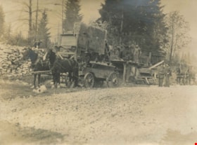
Rock crusher in operation
https://search.heritageburnaby.ca/link/archivedescription39573
- Repository
- City of Burnaby Archives
- Date
- August 1910
- Collection/Fonds
- Peers Family and Hill Family fonds
- Description Level
- Item
- Physical Description
- 1 photograph : b&w ; 7.5 x 10.2 cm on page 21.5 x 28 cm (pasted in album)
- Scope and Content
- Photograph of a rock crusher in operation. From a wall of rocks, a team of men puts the rock into the rock crusher. The crushed gravel is loaded up in a horse drawn cart, with a driver ready to transport it away. There are two men in suits to the right of the photograph watching the operation.
- Repository
- City of Burnaby Archives
- Date
- August 1910
- Collection/Fonds
- Peers Family and Hill Family fonds
- Physical Description
- 1 photograph : b&w ; 7.5 x 10.2 cm on page 21.5 x 28 cm (pasted in album)
- Description Level
- Item
- Record No.
- 477-892
- Access Restriction
- No restrictions
- Reproduction Restriction
- No known restrictions
- Accession Number
- 2007-12
- Scope and Content
- Photograph of a rock crusher in operation. From a wall of rocks, a team of men puts the rock into the rock crusher. The crushed gravel is loaded up in a horse drawn cart, with a driver ready to transport it away. There are two men in suits to the right of the photograph watching the operation.
- Names
- Oakalla Prison Farm
- Media Type
- Photograph
- Notes
- Title based on contents of photograph
- Geographic Access
- Oakmount Crescent
- Street Address
- 5220 Oakmount Crescent
- Historic Neighbourhood
- Burnaby Lake (Historic Neighbourhood)
- Planning Study Area
- Oakalla Area
Images

Alfred Bingham's writings - Track 1
https://search.heritageburnaby.ca/link/oralhistory251
- Repository
- City of Burnaby Archives
- Date Range
- 1865-1919
- Length
- 0:10:18
- Summary
- This portion of the recording includes Alfred Bingham's essay entitled Stump Rangers, a listing of early settlers that includes addresses and short descriptions, essays on Confederation Park, land clearing and on Burnaby's first Council meeting.
- Repository
- City of Burnaby Archives
- Summary
- This portion of the recording includes Alfred Bingham's essay entitled Stump Rangers, a listing of early settlers that includes addresses and short descriptions, essays on Confederation Park, land clearing and on Burnaby's first Council meeting.
- Date Range
- 1865-1919
- Photo Info
- Alfred Bingham, April 20, 1947. Item no. 010-066
- Length
- 0:10:18
- Scope and Content
- Recording is of Alfred Bingham's writings, as read by Alfred Bingham. Major themes discussed are: Pioneers, early days in Burnaby and the Co-op Movement. To view "Narrow By" terms for each track expand this description and see "Notes".
- Biographical Notes
- Alfred "Alf" Bingham was born in England in 1892 and moved to Canada in 1912. His first job in Canada was laying track for the Grand Trunk Pacific Railway (GTPR) from Edmonton to McBride in 1912. His second was in Vancouver at the Rat Portage Mill on False Creek, working on the Resaw machine. He quit after one week due to poor working conditions. After taking part in the 1919 Winnipeg General Strike as a delegate of the Retail and Mailorder Union (A.F.L.) on the Winnipeg Trades and Labour Council, Alfred moved to Burnaby where he and fellow Burnaby residents Aungus McLean and Percy Little worked ten hour days to build a Shingle Mill on the edge of Burnaby Lake for Simpson & Giberson. George Green, carpenter and millwright (author of “The History of Burnaby”) also helped in the construction of the mill. Alfred built his own home from lumber cut from the mill in the Lochdale area on Sherlock Street between Curtis Street and Kitchener Street. On April 10, 1920 Alfred married Mary Jane “Ada” Reynolds. Alfred and Ada often took in foster children during their marriage. Due to her nursing experience, Ada was often called upon to deliver babies in the Burnaby area. Alfred and Ada Bingham were instrumental members of the Army of the Common Good, collecting vegetables and grains from growers in the area and even producing over 125 tons of vegetables from its own gardens to feed children and youth suffering from the lack of resources during the Depression years. The army was in operation for ten years and during that time the members organised the Credit Union movement of British Columbia and drew up the Credit Union act thorough the Vancouver Co-operative Council. They also started Co-Op stores and the Co-Op Wholesale Society. Alfred was also Secretary of the Burnaby Housing committee and in 1946 he became the Secretary of the North Burnaby Labour Progressive Party (LPP). Mary Jane “Ada” (Reynolds) Bingham died on August 9, 1969. Her husband Alfred died on April 29, 1979.
- Total Tracks
- 12
- Total Length
- 1:38:06
- Interviewee Name
- Bingham, Alfred "Alf"
- Collection/Fonds
- Burnaby Historical Society fonds
- Subseries
- Oral history subseries
- Transcript Available
- MSS142-001 contains transcripts for each of the short stories
- Media Type
- Sound Recording
- Web Notes
- Interview was digitized in 2010 allowing it to be accessible on Heritage Burnaby. The digitization project was initiated by the Community Heritage Commission with support from City of Burnaby Council and the BC History Digitization Program of the Irving K. Barber Learning Centre, University of British Columbia. It was recognized by the Heritage Society of BC with an award in 2012.
Images

Audio Tracks
Track one of recording of Alfred Bingham's writings
Track one of recording of Alfred Bingham's writings
https://search.heritageburnaby.ca/media/hpo/_Data/_Archives_Oral_Histories/_Unrestricted/100-13-20-2/100-13-20-2_Track_1.mp3
Alfred Bingham's writings - Track 2
https://search.heritageburnaby.ca/link/oralhistory252
- Repository
- City of Burnaby Archives
- Date Range
- 1919-1955
- Length
- 0:06:06
- Summary
- This portion of the recording includes Alfred Bingham's memories of constructing a mill for Simpson & Giberson and of working on homes for himself, Angus McLean and Percy Little in the Lochdale area. He discusses the strike at Barnet mill and reads an essay written by Grace E. Carpenter. Land clear…
- Repository
- City of Burnaby Archives
- Summary
- This portion of the recording includes Alfred Bingham's memories of constructing a mill for Simpson & Giberson and of working on homes for himself, Angus McLean and Percy Little in the Lochdale area. He discusses the strike at Barnet mill and reads an essay written by Grace E. Carpenter. Land clearing is described in detail. Alfred also relates a story from 1920 involving early settlers E. Powell and J. Amos.
- Date Range
- 1919-1955
- Photo Info
- Alfred Bingham, April 20, 1947. Item no. 010-066
- Length
- 0:06:06
- Historic Neighbourhood
- Lochdale (Historic Neighbourhood)
- Planning Study Area
- Lochdale Area
- Scope and Content
- Recording is of Alfred Bingham's writings, as read by Alfred Bingham. Major themes discussed are: Pioneers, early days in Burnaby and the Co-op Movement. To view "Narrow By" terms for each track expand this description and see "Notes".
- Biographical Notes
- Alfred "Alf" Bingham was born in England in 1892 and moved to Canada in 1912. His first job in Canada was laying track for the Grand Trunk Pacific Railway (GTPR) from Edmonton to McBride in 1912. His second was in Vancouver at the Rat Portage Mill on False Creek, working on the Resaw machine. He quit after one week due to poor working conditions. After taking part in the 1919 Winnipeg General Strike as a delegate of the Retail and Mailorder Union (A.F.L.) on the Winnipeg Trades and Labour Council, Alfred moved to Burnaby where he and fellow Burnaby residents Aungus McLean and Percy Little worked ten hour days to build a Shingle Mill on the edge of Burnaby Lake for Simpson & Giberson. George Green, carpenter and millwright (author of “The History of Burnaby”) also helped in the construction of the mill. Alfred built his own home from lumber cut from the mill in the Lochdale area on Sherlock Street between Curtis Street and Kitchener Street. On April 10, 1920 Alfred married Mary Jane “Ada” Reynolds. Alfred and Ada often took in foster children during their marriage. Due to her nursing experience, Ada was often called upon to deliver babies in the Burnaby area. Alfred and Ada Bingham were instrumental members of the Army of the Common Good, collecting vegetables and grains from growers in the area and even producing over 125 tons of vegetables from its own gardens to feed children and youth suffering from the lack of resources during the Depression years. The army was in operation for ten years and during that time the members organised the Credit Union movement of British Columbia and drew up the Credit Union act thorough the Vancouver Co-operative Council. They also started Co-Op stores and the Co-Op Wholesale Society. Alfred was also Secretary of the Burnaby Housing committee and in 1946 he became the Secretary of the North Burnaby Labour Progressive Party (LPP). Mary Jane “Ada” (Reynolds) Bingham died on August 9, 1969. Her husband Alfred died on April 29, 1979.
- Total Tracks
- 12
- Total Length
- 1:38:06
- Interviewee Name
- Bingham, Alfred "Alf"
- Collection/Fonds
- Burnaby Historical Society fonds
- Subseries
- Oral history subseries
- Transcript Available
- MSS142-001 contains transcripts for each of the short stories
- Media Type
- Sound Recording
- Web Notes
- Interview was digitized in 2010 allowing it to be accessible on Heritage Burnaby. The digitization project was initiated by the Community Heritage Commission with support from City of Burnaby Council and the BC History Digitization Program of the Irving K. Barber Learning Centre, University of British Columbia. It was recognized by the Heritage Society of BC with an award in 2012.
Images
Audio Tracks
Track two of recording of Alfred Bingham's writings
Track two of recording of Alfred Bingham's writings
https://search.heritageburnaby.ca/media/hpo/_Data/_Archives_Oral_Histories/_Unrestricted/100-13-20-2/100-13-20-2_Track_2.mp3
Alfred Bingham's writings - Track 3
https://search.heritageburnaby.ca/link/oralhistory253
- Repository
- City of Burnaby Archives
- Date Range
- 1903-1940
- Length
- 0:09:46
- Summary
- This portion of the recording includes Alfred Bingham's descriptions of road construction in Burnaby, including the names of the settlers and logging companies involved in their construction. Alfred discusses the changes that took place during World War I, along with municipal Relief work that he t…
- Repository
- City of Burnaby Archives
- Summary
- This portion of the recording includes Alfred Bingham's descriptions of road construction in Burnaby, including the names of the settlers and logging companies involved in their construction. Alfred discusses the changes that took place during World War I, along with municipal Relief work that he took part in at Burnaby Mountain. Alfred also discusses early schools and mentions his wife, Ada Bingham.
- Date Range
- 1903-1940
- Photo Info
- Alfred Bingham, April 20, 1947. Item no. 010-066
- Length
- 0:09:46
- Planning Study Area
- Burnaby Mountain Area
- Scope and Content
- Recording is of Alfred Bingham's writings, as read by Alfred Bingham. Major themes discussed are: Pioneers, early days in Burnaby and the Co-op Movement. To view "Narrow By" terms for each track expand this description and see "Notes".
- Biographical Notes
- Alfred "Alf" Bingham was born in England in 1892 and moved to Canada in 1912. His first job in Canada was laying track for the Grand Trunk Pacific Railway (GTPR) from Edmonton to McBride in 1912. His second was in Vancouver at the Rat Portage Mill on False Creek, working on the Resaw machine. He quit after one week due to poor working conditions. After taking part in the 1919 Winnipeg General Strike as a delegate of the Retail and Mailorder Union (A.F.L.) on the Winnipeg Trades and Labour Council, Alfred moved to Burnaby where he and fellow Burnaby residents Aungus McLean and Percy Little worked ten hour days to build a Shingle Mill on the edge of Burnaby Lake for Simpson & Giberson. George Green, carpenter and millwright (author of “The History of Burnaby”) also helped in the construction of the mill. Alfred built his own home from lumber cut from the mill in the Lochdale area on Sherlock Street between Curtis Street and Kitchener Street. On April 10, 1920 Alfred married Mary Jane “Ada” Reynolds. Alfred and Ada often took in foster children during their marriage. Due to her nursing experience, Ada was often called upon to deliver babies in the Burnaby area. Alfred and Ada Bingham were instrumental members of the Army of the Common Good, collecting vegetables and grains from growers in the area and even producing over 125 tons of vegetables from its own gardens to feed children and youth suffering from the lack of resources during the Depression years. The army was in operation for ten years and during that time the members organised the Credit Union movement of British Columbia and drew up the Credit Union act thorough the Vancouver Co-operative Council. They also started Co-Op stores and the Co-Op Wholesale Society. Alfred was also Secretary of the Burnaby Housing committee and in 1946 he became the Secretary of the North Burnaby Labour Progressive Party (LPP). Mary Jane “Ada” (Reynolds) Bingham died on August 9, 1969. Her husband Alfred died on April 29, 1979.
- Total Tracks
- 12
- Total Length
- 1:38:06
- Interviewee Name
- Bingham, Alfred "Alf"
- Collection/Fonds
- Burnaby Historical Society fonds
- Subseries
- Oral history subseries
- Transcript Available
- MSS142-001 contains transcripts for each of the short stories
- Media Type
- Sound Recording
- Web Notes
- Interview was digitized in 2010 allowing it to be accessible on Heritage Burnaby. The digitization project was initiated by the Community Heritage Commission with support from City of Burnaby Council and the BC History Digitization Program of the Irving K. Barber Learning Centre, University of British Columbia. It was recognized by the Heritage Society of BC with an award in 2012.
Images
Audio Tracks
Track three of recording of Alfred Bingham's writings
Track three of recording of Alfred Bingham's writings
https://search.heritageburnaby.ca/media/hpo/_Data/_Archives_Oral_Histories/_Unrestricted/100-13-20-2/100-13-20-2_Track_3.mp3
Alfred Bingham's writings - Track 7
https://search.heritageburnaby.ca/link/oralhistory257
- Repository
- City of Burnaby Archives
- Date Range
- 1919-1939
- Length
- 0:09:44
- Summary
- This portion of the recording includes Alfred Bingham's continuation of reading his series of short stories. He reads "WHAT THE LOCHDALE DISTRICT LOOKED LIKE IN 1919-20-21-22" and "1st and SECOND SETTLERS IN THE LOCHDALE DISTRICT" both written in 1963.
- Repository
- City of Burnaby Archives
- Summary
- This portion of the recording includes Alfred Bingham's continuation of reading his series of short stories. He reads "WHAT THE LOCHDALE DISTRICT LOOKED LIKE IN 1919-20-21-22" and "1st and SECOND SETTLERS IN THE LOCHDALE DISTRICT" both written in 1963.
- Date Range
- 1919-1939
- Photo Info
- Alfred Bingham, April 20, 1947. Item no. 010-066
- Length
- 0:09:44
- Subjects
- Land Clearing
- Historic Neighbourhood
- Lochdale (Historic Neighbourhood)
- Planning Study Area
- Burnaby Mountain Area
- Scope and Content
- Recording is of Alfred Bingham's writings, as read by Alfred Bingham. Major themes discussed are: Pioneers, early days in Burnaby and the Co-op Movement. To view "Narrow By" terms for each track expand this description and see "Notes".
- Biographical Notes
- Alfred "Alf" Bingham was born in England in 1892 and moved to Canada in 1912. His first job in Canada was laying track for the Grand Trunk Pacific Railway (GTPR) from Edmonton to McBride in 1912. His second was in Vancouver at the Rat Portage Mill on False Creek, working on the Resaw machine. He quit after one week due to poor working conditions. After taking part in the 1919 Winnipeg General Strike as a delegate of the Retail and Mailorder Union (A.F.L.) on the Winnipeg Trades and Labour Council, Alfred moved to Burnaby where he and fellow Burnaby residents Aungus McLean and Percy Little worked ten hour days to build a Shingle Mill on the edge of Burnaby Lake for Simpson & Giberson. George Green, carpenter and millwright (author of “The History of Burnaby”) also helped in the construction of the mill. Alfred built his own home from lumber cut from the mill in the Lochdale area on Sherlock Street between Curtis Street and Kitchener Street. On April 10, 1920 Alfred married Mary Jane “Ada” Reynolds. Alfred and Ada often took in foster children during their marriage. Due to her nursing experience, Ada was often called upon to deliver babies in the Burnaby area. Alfred and Ada Bingham were instrumental members of the Army of the Common Good, collecting vegetables and grains from growers in the area and even producing over 125 tons of vegetables from its own gardens to feed children and youth suffering from the lack of resources during the Depression years. The army was in operation for ten years and during that time the members organised the Credit Union movement of British Columbia and drew up the Credit Union act thorough the Vancouver Co-operative Council. They also started Co-Op stores and the Co-Op Wholesale Society. Alfred was also Secretary of the Burnaby Housing committee and in 1946 he became the Secretary of the North Burnaby Labour Progressive Party (LPP). Mary Jane “Ada” (Reynolds) Bingham died on August 9, 1969. Her husband Alfred died on April 29, 1979.
- Total Tracks
- 12
- Total Length
- 1:38:06
- Interviewee Name
- Bingham, Alfred "Alf"
- Collection/Fonds
- Burnaby Historical Society fonds
- Subseries
- Oral history subseries
- Transcript Available
- MSS142-001 contains transcripts for each of the short stories
- Media Type
- Sound Recording
- Web Notes
- Interview was digitized in 2010 allowing it to be accessible on Heritage Burnaby. The digitization project was initiated by the Community Heritage Commission with support from City of Burnaby Council and the BC History Digitization Program of the Irving K. Barber Learning Centre, University of British Columbia. It was recognized by the Heritage Society of BC with an award in 2012.
Images
Audio Tracks
Track seven of recording of Alfred Bingham's writings
Track seven of recording of Alfred Bingham's writings
https://search.heritageburnaby.ca/media/hpo/_Data/_Archives_Oral_Histories/_Unrestricted/100-13-20-2/100-13-20-2_Track_7.mp3
Armstrong Avenue school site
https://search.heritageburnaby.ca/link/archivedescription34064
- Repository
- City of Burnaby Archives
- Date
- 1911
- Collection/Fonds
- Burnaby Historical Society fonds
- Description Level
- Item
- Physical Description
- 1 photograph : b&w postcard ; 6.2 x 10.4 cm
- Scope and Content
- Photographic postcard of men sawing down a tree at the Armstrong Avenue School site at 8757 Armstrong Avenue. The accompanying description refers to it as the "bee tree."
- Repository
- City of Burnaby Archives
- Date
- 1911
- Collection/Fonds
- Burnaby Historical Society fonds
- Subseries
- Photographs subseries
- Physical Description
- 1 photograph : b&w postcard ; 6.2 x 10.4 cm
- Description Level
- Item
- Record No.
- 007-001
- Access Restriction
- No restrictions
- Reproduction Restriction
- No known restrictions
- Accession Number
- BHS2007-04
- Scope and Content
- Photographic postcard of men sawing down a tree at the Armstrong Avenue School site at 8757 Armstrong Avenue. The accompanying description refers to it as the "bee tree."
- Names
- Armstrong Avenue School
- Media Type
- Photograph
- Notes
- Title based on contents of photograph
- Postcard has been cropped
- Geographic Access
- Armstrong Avenue
- Street Address
- 8757 Armstrong Avenue
- Historic Neighbourhood
- East Burnaby (Historic Neighbourhood)
- Planning Study Area
- Cariboo-Armstrong Area
Images


B.G. Walker house
https://search.heritageburnaby.ca/link/archivedescription35002
- Repository
- City of Burnaby Archives
- Date
- 1910 (date of original), copied 1986
- Collection/Fonds
- Burnaby Historical Society fonds
- Description Level
- Item
- Physical Description
- 1 photograph : b&w postcard ; 8.4 x 13.8 cm
- Scope and Content
- Photographic postcard of the B.G. Walker house, Edmonds Street and Kingsway. Note the cedar stumps in background.
- Repository
- City of Burnaby Archives
- Date
- 1910 (date of original), copied 1986
- Collection/Fonds
- Burnaby Historical Society fonds
- Subseries
- Patterson family subseries
- Physical Description
- 1 photograph : b&w postcard ; 8.4 x 13.8 cm
- Description Level
- Item
- Record No.
- 171-023
- Access Restriction
- Open access
- Reproduction Restriction
- No known restrictions
- Accession Number
- BHS1986-20
- Scope and Content
- Photographic postcard of the B.G. Walker house, Edmonds Street and Kingsway. Note the cedar stumps in background.
- Media Type
- Photograph
- Notes
- Title based on contents of photograph
- Geographic Access
- Edmonds Street
- Kingsway
- Historic Neighbourhood
- Edmonds (Historic Neighbourhood)
Images

![Blasted stump, [1910 or 1911] thumbnail](/media/hpo/_Data/_Archives_Images/_Unrestricted/487/487-037.jpg?width=280)
Blasted stump
https://search.heritageburnaby.ca/link/archivedescription65899
- Repository
- City of Burnaby Archives
- Date
- [1910 or 1911]
- Collection/Fonds
- J.W. Phillips fonds
- Description Level
- Item
- Physical Description
- 1 photograph : b&w glass negative ; 11 x 15.5 cm
- Scope and Content
- Photograph of an unidentified man (likely either Jack Holmes) helping to clear land near the Phillips home on Ellsemere Avenue. He is standing in front of the stump that he just blasted, resting an axe at his side. The stump is in pieces and still smoldering.
- Repository
- City of Burnaby Archives
- Date
- [1910 or 1911]
- Collection/Fonds
- J.W. Phillips fonds
- Physical Description
- 1 photograph : b&w glass negative ; 11 x 15.5 cm
- Material Details
- Emulsion measures 11 x 15.5 cm on the glass; entire glass plate measures 16 x 12 cm
- Description Level
- Item
- Record No.
- 487-037
- Access Restriction
- No restrictions
- Reproduction Restriction
- No known restrictions
- Accession Number
- 2008-18
- Scope and Content
- Photograph of an unidentified man (likely either Jack Holmes) helping to clear land near the Phillips home on Ellsemere Avenue. He is standing in front of the stump that he just blasted, resting an axe at his side. The stump is in pieces and still smoldering.
- Subjects
- Land Clearing
- Media Type
- Photograph
- Photographer
- Phillips, James William "Jim"
- Notes
- Title based on contents of photograph
- Geographic Access
- Ellesmere Avenue
- Street Address
- 200 Ellesmere Avenue
- Historic Neighbourhood
- Capitol Hill (Historic Neighbourhood)
- Planning Study Area
- Capitol Hill Area
Images
![Blasted stump, [1910 or 1911] thumbnail](/media/hpo/_Data/_Archives_Images/_Unrestricted/487/487-037.jpg)
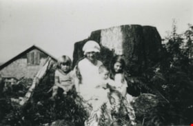
Bonnett family
https://search.heritageburnaby.ca/link/archivedescription37005
- Repository
- City of Burnaby Archives
- Date
- 1918 (date of original), copied 1992
- Collection/Fonds
- Burnaby Historical Society fonds
- Description Level
- Item
- Physical Description
- 1 photograph : b&w ; 8.7 x 12.7 cm print
- Scope and Content
- Photograph of Mrs. Una Bonnett and three of her childen: (left to right) Victor, Thais and Austa, at their family home at 21 North Hythe Avenue. A large stump is visible in the background.
- Repository
- City of Burnaby Archives
- Date
- 1918 (date of original), copied 1992
- Collection/Fonds
- Burnaby Historical Society fonds
- Subseries
- Burnaby Centennial Anthology subseries
- Physical Description
- 1 photograph : b&w ; 8.7 x 12.7 cm print
- Description Level
- Item
- Record No.
- 315-463
- Access Restriction
- No restrictions
- Reproduction Restriction
- No known restrictions
- Accession Number
- BHS1994-04
- Scope and Content
- Photograph of Mrs. Una Bonnett and three of her childen: (left to right) Victor, Thais and Austa, at their family home at 21 North Hythe Avenue. A large stump is visible in the background.
- Subjects
- Land Clearing
- Media Type
- Photograph
- Notes
- Title based on contents of photograph
- Geographic Access
- Hythe Avenue North
- Street Address
- 21 Hythe Avenue North
- Historic Neighbourhood
- Capitol Hill (Historic Neighbourhood)
- Planning Study Area
- Capitol Hill Area
Images
![Burrard Inlet, [1912] (date of original), copied 1986 thumbnail](/media/hpo/_Data/_Archives_Images/_Unrestricted/204/204-704.jpg?width=280)
Burrard Inlet
https://search.heritageburnaby.ca/link/archivedescription35845
- Repository
- City of Burnaby Archives
- Date
- [1912] (date of original), copied 1986
- Collection/Fonds
- Burnaby Historical Society fonds
- Description Level
- Item
- Physical Description
- 1 photograph : b&w ; 12.7 x 17.8 cm print
- Scope and Content
- Photograph of Burrard Inlet taken looking north from Capitol Hill.
- Repository
- City of Burnaby Archives
- Date
- [1912] (date of original), copied 1986
- Collection/Fonds
- Burnaby Historical Society fonds
- Subseries
- Pioneer Tales subseries
- Physical Description
- 1 photograph : b&w ; 12.7 x 17.8 cm print
- Description Level
- Item
- Record No.
- 204-704
- Access Restriction
- No restrictions
- Reproduction Restriction
- No known restrictions
- Accession Number
- BHS1988-03
- Scope and Content
- Photograph of Burrard Inlet taken looking north from Capitol Hill.
- Media Type
- Photograph
- Photographer
- Phillips, James William "Jim"
- Notes
- Title based on contents of photograph
- Historic Neighbourhood
- Capitol Hill (Historic Neighbourhood)
- Planning Study Area
- Capitol Hill Area
Images
![Burrard Inlet, [1912] (date of original), copied 1986 thumbnail](/media/hpo/_Data/_Archives_Images/_Unrestricted/204/204-704.jpg)

Camp at Oakalla Site
https://search.heritageburnaby.ca/link/archivedescription39575
- Repository
- City of Burnaby Archives
- Date
- 1910
- Collection/Fonds
- Peers Family and Hill Family fonds
- Description Level
- Item
- Physical Description
- 1 photograph : b&w ; 7.7 x 10.4 cm on page 21.5 x 28 cm (pasted in album)
- Scope and Content
- Photograph of the land clearing operation at the Oakalla Prison site in the Deer Lake area. Claude Hill is in the centre between two unidentified men. A line of clothes is hanging in the background.
- Repository
- City of Burnaby Archives
- Date
- 1910
- Collection/Fonds
- Peers Family and Hill Family fonds
- Physical Description
- 1 photograph : b&w ; 7.7 x 10.4 cm on page 21.5 x 28 cm (pasted in album)
- Description Level
- Item
- Record No.
- 477-894
- Access Restriction
- No restrictions
- Reproduction Restriction
- No known restrictions
- Accession Number
- 2007-12
- Scope and Content
- Photograph of the land clearing operation at the Oakalla Prison site in the Deer Lake area. Claude Hill is in the centre between two unidentified men. A line of clothes is hanging in the background.
- Subjects
- Land Clearing
- Media Type
- Photograph
- Notes
- Title based on contents of photograph
- Geographic Access
- Oakmount Crescent
- Street Address
- 5220 Oakmount Crescent
- Historic Neighbourhood
- Burnaby Lake (Historic Neighbourhood)
- Planning Study Area
- Oakalla Area
Images


Clearing Gough Family Lot
https://search.heritageburnaby.ca/link/archivedescription35486
- Repository
- City of Burnaby Archives
- Date
- 1912 (date of original), copied 1986
- Collection/Fonds
- Burnaby Historical Society fonds
- Description Level
- Item
- Physical Description
- 1 photograph : b&w ; 12.7 x 17.8 cm print
- Scope and Content
- Photograph of the Gough family and relatives clearing the lot for the family home on Nelson Avenue, Alta Vista. Identified in the photo (back row, centre) Donald Gough. Others in picture are aunts and uncles named Evans. Donald was the son of Agnes Gough and her husband William, who settled here…
- Repository
- City of Burnaby Archives
- Date
- 1912 (date of original), copied 1986
- Collection/Fonds
- Burnaby Historical Society fonds
- Subseries
- Pioneer Tales subseries
- Physical Description
- 1 photograph : b&w ; 12.7 x 17.8 cm print
- Description Level
- Item
- Record No.
- 204-344
- Access Restriction
- No restrictions
- Reproduction Restriction
- No known restrictions
- Accession Number
- BHS1988-03
- Scope and Content
- Photograph of the Gough family and relatives clearing the lot for the family home on Nelson Avenue, Alta Vista. Identified in the photo (back row, centre) Donald Gough. Others in picture are aunts and uncles named Evans. Donald was the son of Agnes Gough and her husband William, who settled here at 2119 Nelson Avenue (later 7126 Nelson Avenue).
- Subjects
- Land Clearing
- Names
- Evans Family
- Gough, Donald
- Media Type
- Photograph
- Notes
- Title based on contents of photograph
- Annotation at top of photograph reads, "Nelson & Victory Sts - 1912"
- Geographic Access
- Nelson Avenue
- Street Address
- 7126 Nelson Avenue
- Historic Neighbourhood
- Alta-Vista (Historic Neighbourhood)
- Planning Study Area
- Sussex-Nelson Area
Images

![Clearing land, [1910 or 1911] thumbnail](/media/hpo/_Data/_Archives_Images/_Unrestricted/487/487-038.jpg?width=280)
Clearing land
https://search.heritageburnaby.ca/link/archivedescription65900
- Repository
- City of Burnaby Archives
- Date
- [1910 or 1911]
- Collection/Fonds
- J.W. Phillips fonds
- Description Level
- Item
- Physical Description
- 1 photograph : b&w glass negative ; 15.5 x 11 cm
- Scope and Content
- Photograph of three men clearing land (most likely) on the Phillips family property. John George "George" Phillips and his father William James Phillips appear to be standing on running boards at the base of a large felled tree. The third man, sitting at the base of the stump, is unidentified.
- Repository
- City of Burnaby Archives
- Date
- [1910 or 1911]
- Collection/Fonds
- J.W. Phillips fonds
- Physical Description
- 1 photograph : b&w glass negative ; 15.5 x 11 cm
- Material Details
- Emulsion measures 15.5 x 11 cm on the glass; entire glass plate measures 16 x 12 cm
- Description Level
- Item
- Record No.
- 487-038
- Access Restriction
- No restrictions
- Reproduction Restriction
- No known restrictions
- Accession Number
- 2008-18
- Scope and Content
- Photograph of three men clearing land (most likely) on the Phillips family property. John George "George" Phillips and his father William James Phillips appear to be standing on running boards at the base of a large felled tree. The third man, sitting at the base of the stump, is unidentified.
- Subjects
- Land Clearing
- Media Type
- Photograph
- Photographer
- Phillips, James William "Jim"
- Notes
- Title based on contents of photograph
- Geographic Access
- Ellesmere Avenue
- Historic Neighbourhood
- Capitol Hill (Historic Neighbourhood)
- Planning Study Area
- Capitol Hill Area
Images
![Clearing land, [1910 or 1911] thumbnail](/media/hpo/_Data/_Archives_Images/_Unrestricted/487/487-038.jpg)