Narrow Results By
Decade
- 2020s 84
- 2010s 213
- 2000s 392
- 1990s 565
- 1980s 550
- 1970s 708
- 1960s 563
- 1950s
- 1940s 546
- 1930s 754
- 1920s 704
- 1910s 639
- 1900s 304
- 1890s 166
- 1880s 26
- 1870s 14
- 1860s
- 1850s 7
- 1840s 3
- 1830s
- 1820s 2
- 1810s 2
- 1800s 2
- 1790s 1
- 1780s 1
- 1770s 1
- 1760s 1
- 1750s 1
- 1740s 1
- 1730s 1
- 1720s 1
- 1710s 1
- 1700s 1
- 1690s 1
- 1680s 1
- 1670s 1
- 1660s 1
- 1650s 1
- 1640s 1
- 1630s 1
- 1620s 1
- 1610s 1
- 1600s 1
Creator
- Adair, Neal G. 3
- Adams, Edith 3
- Adkins, H. E. (Hector Ernest), 1885-1962 1
- Aero Surveys Limited 2
- Andrews, Ralph W. (Ralph Warren), 1897-1988 1
- Archives of Vancouver Society 1
- Associated Factory Mutual Fire Insurance Cos 1
- Atkinson, Dorothy Mallett 1
- Bancroft, Rose 1
- Bateman, Caroline Mary Wettenhall 1
- Bate, May 1
- Bergson, George 3
![Staff reunion party, [between 1940 and 1950] thumbnail](/media/hpo/_Data/_BVM_Images/2017/2017_0038_0011_001.jpg?width=280)
Staff reunion party
https://search.heritageburnaby.ca/link/museumdescription4646
- Repository
- Burnaby Village Museum
- Date
- [between 1940 and 1950]
- Collection/Fonds
- Burnaby Village Museum Photograph collection
- Description Level
- Item
- Physical Description
- 1 photograph : b&w ; 20 x 25 cm
- Scope and Content
- Photograph of a staff reunion floor party for employees of the dressmaking department at "The Bay" department store. Flossie Parsons can be seen seated near the centre of the photograph in the white sweater.
- Repository
- Burnaby Village Museum
- Collection/Fonds
- Burnaby Village Museum Photograph collection
- Description Level
- Item
- Physical Description
- 1 photograph : b&w ; 20 x 25 cm
- Scope and Content
- Photograph of a staff reunion floor party for employees of the dressmaking department at "The Bay" department store. Flossie Parsons can be seen seated near the centre of the photograph in the white sweater.
- History
- Flossie Maude Parsons (nee Smith) was born to George Henry Smith, a farm labourer, and Harriet Ann Savage on February 13, 1896 in Ealing, England. She immigrated to Canada with some of her family members in the early 1920s. They lived in Winnipeg for a few years as an older brother had settled there in 1912. She married Herbert Russell Parsons on June 23, 1928. They first lived in Vancouver and finally bought a home at 7091 Jubilee Avenue, South Burnaby in the early 1930s. In 1943, Flossie was certified in Home Nursing. Herbert Parsons was active during the Second World War as a volunteer for Civil Defence in Burnaby and worked as a salesman for Woodwards. The couple had no children. Herbert passed away on May 23rd, 1957 (age 84) and Flossie passed away on April 6, 1996 (age 100).
- Other Title Information
- Title based on content of photograph
- Accession Code
- BV017.38.11
- Access Restriction
- No restrictions
- Reproduction Restriction
- May be restricted by third party rights
- Date
- [between 1940 and 1950]
- Media Type
- Photograph
- Scan Resolution
- 600
- Scan Date
- 26-Mar-2018
Images
![Staff reunion party, [between 1940 and 1950] thumbnail](/media/hpo/_Data/_BVM_Images/2017/2017_0038_0011_001.jpg)
![Survey and Subdivision plans in New Westminster District Group 1 – Burnaby
, [1861]-[1910] thumbnail](/media/hpo/_Data/_BVM_Cartographic_Material/1977/1977_0093_0019a_001.jpg?width=280)
Survey and Subdivision plans in New Westminster District Group 1 – Burnaby
https://search.heritageburnaby.ca/link/museumdescription6988
- Repository
- Burnaby Village Museum
- Date
- [1861]-[1910]
- Collection/Fonds
- Burnaby Village Museum Map collection
- Description Level
- File
- Physical Description
- 14 plans : 3 plans : black ink on paper hand col. + 7 plans : black ink on paper + 4 plans : graphite on paper mounted on 2 sides of cardboard 76 x 102 cm
- Scope and Content
- Item consists of a large board of four New Westminster District Gp 1 - subdivision plans mounted on one side and ten New Westminster District Gp 1 - subdivision plans mounted on the other side. Side A: 1. "Plan /of / Lots 166A, 166 and 167 /, Gr.1, N.W.D. / Showing Misconstructed Roads in Gree…
- Repository
- Burnaby Village Museum
- Collection/Fonds
- Burnaby Village Museum Map collection
- Description Level
- File
- Physical Description
- 14 plans : 3 plans : black ink on paper hand col. + 7 plans : black ink on paper + 4 plans : graphite on paper mounted on 2 sides of cardboard 76 x 102 cm
- Material Details
- Scales [between 1:2376 and 1:7920]
- Index number on edge of board reads: "19"
- Scope and Content
- Item consists of a large board of four New Westminster District Gp 1 - subdivision plans mounted on one side and ten New Westminster District Gp 1 - subdivision plans mounted on the other side. Side A: 1. "Plan /of / Lots 166A, 166 and 167 /, Gr.1, N.W.D. / Showing Misconstructed Roads in Green / 5 chs = 1 in.". (plan is drawn in black ink and hand coloured in red, green and orange ink). A section in the centre of the plan is coloured in red ink and identified as "C.S. Richmond" running from the North Arm of Fraser River to Wiggins Road and divided by "New Wiggins Rd. (as gazetted)" (coloured in orange ink) and two"Constructed Road(s)" (coloured in green ink). Plan is initialed by: "RB" [sic] (in blue pencil crayon) 2. Plan of / Subdivision of / Lot 166 / Group One / New Westminster District / Scale 4 chs = 1 in. / Map No 524". Plan is drawn in graphite and signed by "Surrig [sic] Welhams [sic] / P.L.S." Plan is initialed by: "RB" [sic] (in blue pencil crayon) 3. Plan of "Survey / of Highway / For / Burnaby Council / in / Lots 13 _14 / Group One / Scale 4 chs = 1 in." Signed by "Albert J. Hill, P.L.S." Caribou Street and Caribou Road run through the centre of the plan. Plan is stamped: "Albert J. Hill, Civil Engineer / and / Provincial Land Surveyor, / New Westminster, / B.C.". Plan is initialed by: "RB" [sic] (in blue pencil crayon) 4. A Plan of Lots 166A, 166 and 167, Group One, New Westminster District (drawn in graphite). A section in the centre of the plan is identified as "C.S. Richmond" running from the North Arm of Fraser River and divided by "New Wiggins Rd. (as gazetted)" and two "Constructed Road(s)". Plan is initialed by: "RB" [sic] (in blue pencil crayon) Side B: 1. Small plan drawn in black ink (no title) identifying lots north of the "North Arm" of the Fraser River. Lots identified include: Lot 99, Lot 98, Lot 157, Lot 158, Lot 163, Lot 162, Lot 159, Lot 163, Lot 162, Lot 165, Lot 166A, Lot 155B, Lot 155A and Lot 159. "Scale 40 chains to one inch" . Plan is initialed by: "RB" [sic] (in blue pencil crayon) (Geographic location: Burnaby) 2. Small plan drawn in black ink (no title) identifying lots north of the North Arm of the Fraser River as "Lots 155, 155A, 155B, 155C, 162, 163, 164, 165, 166A and 167". Plan is initialed by: "RB" [sic] (in blue pencil crayon) (Geographic location: Burnaby) 3. Small plan drawn in black ink (no title) which identifies "Lot 151 / Reserve/ for / Race Course"; "Reserve / 64 A / L. 152 G.1"; and other Lots: 32, 33, 34, 35, 36, 38, 39. The plan is signed "Surveyor G.Turn [sic] July / 61 / from Vol 40 R.L. notes [sic]" Plan is stamped: "Albert J. Hill, Civil Engineer / and / Provincial Land Surveyor, / New Westminster, / B.C." Plan is initialed by: "RB" [sic] (in blue pencil crayon) (Geographic location: Burnaby) 4. Small plan drawn in black in with faded red colouring on centre lot identified as "Lot 34" running north from "Vancouver Road" . Plan is stamped: "Albert J. Hill, Civil Engineer / and / Provincial Land Surveyor, / New Westminster, / B.C." Plan is initialed by: "RB" [sic] (in blue pencil crayon) (Geographic location: Burnaby) 5. Plan drawn in graphite and identified as "Lot 98, Gr.1," along with the intials "RB" [sic] (both are handwritten in blue crayon pencil on top of plan) The B.C.E.Railway is identified running through the plan along with Jubilee Road and Royal Oak Road. The plan is signed with the name "Wm. Murray" and the Plan is stamped: "Albert J. Hill, Civil Engineer / and / Provincial Land Surveyor, / New Westminster, / B.C.". (Geographic location: Burnaby) 6. Plan drawn in graphite identified as "Port Lot 13, Gr.1" along with the intials "RB" [sic] (both are handwritten in blue crayon pencil on top of plan) Plan is stamped: "Albert J. Hill, Civil Engineer / and / Provincial Land Surveyor, / New Westminster, / B.C.". (Geographic location: Burnaby) 7.Plan drawn in black ink and identified as "Lot 98 G.1" along with the intials "RB" [sic] (both are handwritten in blue crayon pencil on top of plan). A "Road Reservation" is identified running north between "Electric Tramway" and connecting with "Royal Oak Road". Plan is stamped: "Albert J. Hill, Civil Engineer / and / Provincial Land Surveyor, / New Westminster, / B.C." (Geographic location: Burnaby) 8. Plan drawn in black ink and divided into two sections, the upper plan is identified as "Portion / Lots 100 / area / 101, Gr.1" and the lower plan is identified as "Portion L. 3 G. 1" along with the intials "RB" [sic] (these identifiers are handwritten in blue crayon pencil on top of the plan). Portions of Lot 100 and Lot 101 are each divided into 6 sections and the Portion of Lot 3 plan is divided into 24 sections. The plan includes a note in black ink that reads: " Received from Wm Fromme [sic] / from Wm. Trapp / Nov. 28, 1895 / A. J. T...[sic]". (Geographic location: Burnaby) 9. Plan drawn in black ink (no title) identifying soil, buildings and geographic features in southern Burnaby. The plan is bordered by "New Westminster City" (Tenth Avenue and DL 172) to the south east and DL 173 to the south, DL 158 to the west and the B.C.E. Tramway to the north. Plan includes District Lots: 155A, 158, 159, 171, 160, 53 and 95 and identifies soil, marshland and ravines throughout. Plan identifies the following features: a "Team Road" running through Lots 158 and 159 along with "Fair Orchard Soil / Even Surface Throughout / No Ravines", "Gravel and Shingle" (bottom of Lot 158), "North Arm Road" crossing "Byrne Road" and connecting with "Power House Road" which runs north to connect with "Highland Park Station" and the B.C.E. Tramway, "Power Ho" in the northeast corner of DL 160, a "Brook" connected with a "Deep Ravine" running between DL 53, DL 95 and DL 160 along with "Good Soil" and "Fair Orchard Soil" identified nearby in DL 95. Scale is identified as "10 chs = 1 in." Plan is stamped: "Albert J. Hill, Civil Engineer / and / Provincial Land Surveyor, / New Westminster, / B.C." Plan is initialed by: "RB" [sic] (in blue pencil crayon) (Geographic location: Burnaby) 10. Plan drawn in black ink (no title) with Burnaby Lake and Deer Lake at the centre. The plan is bordered by the following District Lots identified as: 117, 118 and 68 to the west, Lots 80, 79 and 85 to the southwest, Lots 11, 13, and 1 (City of New Westminster) to the south east, the North Road boundary to the east and Lots 8, 56, 57, 59, and 136 to the North. The lower right hand corner of the plan has a small inset which reads: "Burnaby Lake" and "Page 19 R.B. Notes". Plan is initialed by: "RB" [sic] (in blue pencil crayon) (Geographic location: Burnaby)
- Creator
- Hill, Albert James
- Accession Code
- HV977.93.19
- Access Restriction
- No restrictions
- Reproduction Restriction
- No known restrictions
- Date
- [1861]-[1910]
- Media Type
- Cartographic Material
- Scan Resolution
- 300
- Scale
- 72
- Notes
- Title based on contents of file
- Scale is measured in chains. (One chain equals 792 inches)
- The term "Lot" can also refer to a "District Lot”
- Some plans are stamped: "Albert J. Hill, Civil Engineer / and / Provincial Land Surveyor, / New Westminster, / B.C." and intialed: "RB" [sic]
Images
![Survey and Subdivision plans in New Westminster District Group 1 – Burnaby
, [1861]-[1910] thumbnail](/media/hpo/_Data/_BVM_Cartographic_Material/1977/1977_0093_0019a_001.jpg)

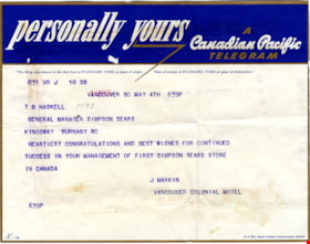
Telegram to general manager of Simpsons-Sears
https://search.heritageburnaby.ca/link/museumdescription17280
- Repository
- Burnaby Village Museum
- Date
- 4 May 1954
- Collection/Fonds
- Simpsons-Sears Limited Burnaby fonds
- Description Level
- Item
- Physical Description
- 1 p.
- Scope and Content
- Item consists of a one page telegram to the General Manager of Simpsons-Sears from J. Markin, Vancouver Colonial Motel expressing congratulations on the opening of the Simpsons-Sears store in Burnaby. Typewritten telegraph with letterhead reading "personally yours / A / Canadian Pacific / Telegram"
- Repository
- Burnaby Village Museum
- Collection/Fonds
- Simpsons-Sears Limited Burnaby fonds
- Description Level
- Item
- Physical Description
- 1 p.
- Scope and Content
- Item consists of a one page telegram to the General Manager of Simpsons-Sears from J. Markin, Vancouver Colonial Motel expressing congratulations on the opening of the Simpsons-Sears store in Burnaby. Typewritten telegraph with letterhead reading "personally yours / A / Canadian Pacific / Telegram"
- Names
- Simpsons-Sears Limited
- Accession Code
- BV021.26.43
- Access Restriction
- No restrictions
- Reproduction Restriction
- No known restrictions
- Date
- 4 May 1954
- Media Type
- Textual Record
- Notes
- Title based on contents of photograph
- Item was removed from original scrapbook with newspaper clippings, photographs and ephemera
Images

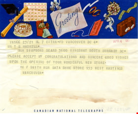
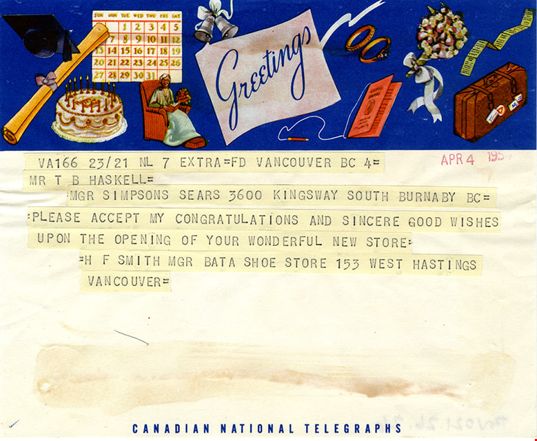
Telegram to T.B. Haskell
https://search.heritageburnaby.ca/link/museumdescription17276
- Repository
- Burnaby Village Museum
- Date
- 5 Apr. 1954
- Collection/Fonds
- Simpsons-Sears Limited Burnaby fonds
- Description Level
- Item
- Physical Description
- 1 p.
- Scope and Content
- Item consists of a one page telegram, dated April 5, 1954 to T.B. Haskell, Manager of Simpsons-Sears, Burnaby from H.F. Smith, Manager Bata Shoe store, 153 West Hastings, Vancouver expressing congratulations on the opening of the Simpsons-Sears store in Burnaby. Typewritten telegraph is adhered to…
- Repository
- Burnaby Village Museum
- Collection/Fonds
- Simpsons-Sears Limited Burnaby fonds
- Description Level
- Item
- Physical Description
- 1 p.
- Scope and Content
- Item consists of a one page telegram, dated April 5, 1954 to T.B. Haskell, Manager of Simpsons-Sears, Burnaby from H.F. Smith, Manager Bata Shoe store, 153 West Hastings, Vancouver expressing congratulations on the opening of the Simpsons-Sears store in Burnaby. Typewritten telegraph is adhered to page, colourful letterhead at top with illustrations and the words "Greetings", bottom of telegram reads "Canadian National Telegraphs".
- Accession Code
- BV021.26.26
- Access Restriction
- No restrictions
- Reproduction Restriction
- No known restrictions
- Date
- 5 Apr. 1954
- Media Type
- Textual Record
- Notes
- Title based on contents of photograph
- Item was removed from original scrapbook with newspaper clippings, photographs and ephemera
Images
This was seafaring : a sea chest of salty memories
https://search.heritageburnaby.ca/link/museumlibrary1090
- Repository
- Burnaby Village Museum
- Collection
- Reference Collection
- Material Type
- Book
- Call Number
- 910.4 AND
- Edition
- 1st ed.
- Place of Publication
- Seattle
- Publisher
- Superior Pub. Co.
- Publication Date
- c1955
- Physical Description
- 168 p. : ill. ; 28 cm.
- Inscription
- "Property of John Thomson / 7231 E. Broadway / Vancouver B.C. / 298 - 8861", handwritten in ink on inside of front cover.
- Library Subject (LOC)
- Seafaring life
![Tokio and Yoshino Yamamoto, [between 1958 and 1965] (date of original), copied 2016 thumbnail](/media/hpo/_Data/_BVM_Images/2016/2016_0011_0010_001.jpg?width=280)
Tokio and Yoshino Yamamoto
https://search.heritageburnaby.ca/link/museumdescription4326
- Repository
- Burnaby Village Museum
- Date
- [between 1958 and 1965] (date of original), copied 2016
- Collection/Fonds
- Tokio and Yoshino Yamamoto family fonds
- Description Level
- Item
- Physical Description
- 1 photograph (tiff)
- Scope and Content
- Photograph of Tokio and Yoshino Yamamoto (nee Tamura). Yoshino is wearing a traditional Japanese kumono and is seated on a chair, Tokio is wearing a suit, standing at her side. Couple is posing in front of a photographer's background of a study. Photograph was taken during a return trip to Japan af…
- Repository
- Burnaby Village Museum
- Collection/Fonds
- Tokio and Yoshino Yamamoto family fonds
- Description Level
- Item
- Physical Description
- 1 photograph (tiff)
- Scope and Content
- Photograph of Tokio and Yoshino Yamamoto (nee Tamura). Yoshino is wearing a traditional Japanese kumono and is seated on a chair, Tokio is wearing a suit, standing at her side. Couple is posing in front of a photographer's background of a study. Photograph was taken during a return trip to Japan after their move to Vancouver in 1958.
- Subjects
- Persons - Japanese Canadians
- Accession Code
- BV016.11.10
- Access Restriction
- No restrictions
- Date
- [between 1958 and 1965] (date of original), copied 2016
- Media Type
- Photograph
- Scan Resolution
- 600
- Scan Date
- 4/24/2016
- Scale
- 100
Images
![Tokio and Yoshino Yamamoto, [between 1958 and 1965] (date of original), copied 2016 thumbnail](/media/hpo/_Data/_BVM_Images/2016/2016_0011_0010_001.jpg)
Tom Irvine
https://search.heritageburnaby.ca/link/archivedescription65553
- Repository
- City of Burnaby Archives
- Date
- 1958
- Collection/Fonds
- Norah Code collection
- Description Level
- Item
- Physical Description
- 1 photograph : b&w ; 7.5 x 7.5 cm
- Scope and Content
- Photograph of Tom Irvine taken at a luncheon given in his honour.
- Repository
- City of Burnaby Archives
- Date
- 1958
- Collection/Fonds
- Norah Code collection
- Physical Description
- 1 photograph : b&w ; 7.5 x 7.5 cm
- Description Level
- Item
- Record No.
- 345-023
- Access Restriction
- No restrictions
- Reproduction Restriction
- Reproduce for fair dealing purposes only
- Accession Number
- 2010-09
- Scope and Content
- Photograph of Tom Irvine taken at a luncheon given in his honour.
- Subjects
- Events
- Names
- Irvine, Tom
- Media Type
- Photograph
- Notes
- Title based on contents of photograph
- Note in blue ink on verso of photograph reads: "Burnaby Courier / Tommy Irvine at a luncheon in his honour / 1958"
- Stamp on verso of photograph reads: "A 'Picture Print' / made by / Vancouver Photo Finishing Co."
- Photographs in this collection were taken and compiled by Norah Code, former editor of the "Burnaby Courier" newspaper during the course of her work for the newspaper
![Tram no. 1007, [between 1930 and 1950] thumbnail](/media/hpo/_Data/_BVM_Images/2000/200200200001.jpg?width=280)
Tram no. 1007
https://search.heritageburnaby.ca/link/museumdescription1611
- Repository
- Burnaby Village Museum
- Date
- [between 1930 and 1950]
- Collection/Fonds
- Burnaby Village Museum Photograph collection
- Description Level
- Item
- Physical Description
- 1 photograph : b&w ; 6 x 10.5 cm
- Scope and Content
- Photograph of British Columbia Electric Railway Company interurban tram no.1007 with "CENTRAL PARK" written on the front board sign and a uniformed conductor at the wheel. The Central Park Interurban rail line connected the Central Park neighbourhood to Vancouver.
- Repository
- Burnaby Village Museum
- Collection/Fonds
- Burnaby Village Museum Photograph collection
- Description Level
- Item
- Physical Description
- 1 photograph : b&w ; 6 x 10.5 cm
- Material Details
- Photograph has scalloped edges
- Scope and Content
- Photograph of British Columbia Electric Railway Company interurban tram no.1007 with "CENTRAL PARK" written on the front board sign and a uniformed conductor at the wheel. The Central Park Interurban rail line connected the Central Park neighbourhood to Vancouver.
- Subjects
- Transportation - Electric Railroads
- Accession Code
- BV002.20.1
- Access Restriction
- Restricted access
- Reproduction Restriction
- May be restricted by third party rights
- Date
- [between 1930 and 1950]
- Media Type
- Photograph
- Scan Resolution
- 600
- Scan Date
- 09-Jun-09
- Scale
- 100
- Photographer
- Steventon, William A.
- Notes
- Title based on contents of photograph
- Stamped on verso of photograph reads: "RAILROAD ["BCE" written in pencil]/ CAR NUMBER ["1007" written in pencil]/ LOCATION / [note on restriction on reproduction]/ WILLIAM A. STEVENTON, Hawkins, Wisconsin"
Images
![Tram no. 1007, [between 1930 and 1950] thumbnail](/media/hpo/_Data/_BVM_Images/2000/200200200001.jpg)
Transit publications
https://search.heritageburnaby.ca/link/archivedescription66115
- Repository
- City of Burnaby Archives
- Date
- 1936-2001
- Collection/Fonds
- Burnaby Historical Society fonds
- Description Level
- File
- Physical Description
- 1 file of textual records
- Scope and Content
- File consists of publications pertaining to transit routes in Burnaby and Vancouver.
- Repository
- City of Burnaby Archives
- Date
- 1936-2001
- Collection/Fonds
- Burnaby Historical Society fonds
- Subseries
- Ephemera subseries
- Physical Description
- 1 file of textual records
- Description Level
- File
- Record No.
- 42717
- Accession Number
- BHS2007-04
- Scope and Content
- File consists of publications pertaining to transit routes in Burnaby and Vancouver.
- Media Type
- Textual Record
- Notes
- Title based on contents of file
![Trans Mountain Oil Pipe Line Co., [1958] thumbnail](/media/Hpo/_Data/_Archives_Images/_Unrestricted/001/097-001.jpg?width=280)
Trans Mountain Oil Pipe Line Co.
https://search.heritageburnaby.ca/link/archivedescription34688
- Repository
- City of Burnaby Archives
- Date
- [1958]
- Collection/Fonds
- Burnaby Historical Society fonds
- Description Level
- Item
- Physical Description
- 1 photograph : b&w ; 20.4 x 25.3 cm
- Scope and Content
- Aerial photograph of the Trans Mountain Oil Pipe Line Co. storage tanks on Burnaby Mountain.
- Repository
- City of Burnaby Archives
- Date
- [1958]
- Collection/Fonds
- Burnaby Historical Society fonds
- Subseries
- Photographs subseries
- Physical Description
- 1 photograph : b&w ; 20.4 x 25.3 cm
- Description Level
- Item
- Record No.
- 097-001
- Access Restriction
- No restrictions
- Reproduction Restriction
- Reproduce for fair dealing purposes only
- Accession Number
- BHS2007-04
- Scope and Content
- Aerial photograph of the Trans Mountain Oil Pipe Line Co. storage tanks on Burnaby Mountain.
- Media Type
- Photograph
- Photographer
- Commercial Illustrators Industrial Photographers
- Notes
- Title based on contents of photograph
- Stamp and annotation on back of photograph reads, "TA. 8817 / Commerical Illustrators / Industrial Photographers / 601 Denman St., Vancouver 5, B.C. / File No. 9412-13"
- Geographic Access
- Burnaby Mountain Conservation Area
- Shellmont Street
- Underhill Avenue
- Planning Study Area
- Lake City Area
Images
![Trans Mountain Oil Pipe Line Co., [1958] thumbnail](/media/Hpo/_Data/_Archives_Images/_Unrestricted/001/097-001.jpg)
![Trans Mountain Pipe Line loading dock, [1958] thumbnail](/media/Hpo/_Data/_Archives_Images/_Unrestricted/001/098-001.jpg?width=280)
Trans Mountain Pipe Line loading dock
https://search.heritageburnaby.ca/link/archivedescription34689
- Repository
- City of Burnaby Archives
- Date
- [1958]
- Collection/Fonds
- Burnaby Historical Society fonds
- Description Level
- Item
- Physical Description
- 1 photograph : b&w ; 20.4 x 25.3 cm
- Scope and Content
- Aerial photograph of the Trans Mountain Pipe Line Westridge loading dock on Burrard Inlet. Houses are visible in the background, and railroad tracks along the edge of the inlet.
- Repository
- City of Burnaby Archives
- Date
- [1958]
- Collection/Fonds
- Burnaby Historical Society fonds
- Subseries
- Photographs subseries
- Physical Description
- 1 photograph : b&w ; 20.4 x 25.3 cm
- Description Level
- Item
- Record No.
- 098-001
- Access Restriction
- No restrictions
- Reproduction Restriction
- Reproduce for fair dealing purposes only
- Accession Number
- BHS2007-04
- Scope and Content
- Aerial photograph of the Trans Mountain Pipe Line Westridge loading dock on Burrard Inlet. Houses are visible in the background, and railroad tracks along the edge of the inlet.
- Media Type
- Photograph
- Photographer
- Commercial Illustrators Industrial Photographers
- Notes
- Title based on contents of photograph
- Stamp and annotation on back of photograph reads, "TA. 8817 / Commerical Illustrators / Industrial Photographers / 601 Denman St., Vancouver 5, B.C. / File No. 9412-2"
- Historic Neighbourhood
- Lochdale (Historic Neighbourhood)
- Planning Study Area
- Westridge Area
Images
![Trans Mountain Pipe Line loading dock, [1958] thumbnail](/media/Hpo/_Data/_Archives_Images/_Unrestricted/001/098-001.jpg)
Treatise on the military band
https://search.heritageburnaby.ca/link/museumlibrary1071
- Repository
- Burnaby Village Museum
- Edition
- 2nd rev. ed.
- Publication Date
- c1958
- Call Number
- 785.06 ADK
- Repository
- Burnaby Village Museum
- Collection
- Reference Collection
- Material Type
- Book
- Call Number
- 785.06 ADK
- Edition
- 2nd rev. ed.
- Place of Publication
- London ; Toronto
- Publisher
- Boosey
- Publication Date
- c1958
- Physical Description
- xi, 326 p. : ill., music ; 24 cm.
- Inscription
- "Gordon Candler", hand written in ink on cover page of book. "G. Candler / PIANO TUNING & REPAIRING / 3035 -EAST 29th AVENUE / VANCOUVER 12, B.C. / Phone: 433-1481" stamped in ink on cover page of book. "G. Candler / 6826 BALMORAL ST. / BURNABY 1, B.C. / 524-6283" stamped in ink on cover page of book.
- Library Subject (LOC)
- Music

View from Kask's Camp
https://search.heritageburnaby.ca/link/archivedescription35531
- Repository
- City of Burnaby Archives
- Date
- 1950 (date of original), copied 1986
- Collection/Fonds
- Burnaby Historical Society fonds
- Description Level
- Item
- Physical Description
- 1 photograph : b&w ; 12.7 x 17.8 cm print
- Scope and Content
- Photograph of top of the hill moved by William Kask, Sr. at the request of Jenny Korhonen Kask who wanted a better view of Burrard Inlet and the islands from her house in Kask's Camp, later Kask Bros. Cement Works. Mr. Kask had the top of the mountain shave off with a bulldozer. A Vancouver Sun h…
- Repository
- City of Burnaby Archives
- Date
- 1950 (date of original), copied 1986
- Collection/Fonds
- Burnaby Historical Society fonds
- Subseries
- Pioneer Tales subseries
- Physical Description
- 1 photograph : b&w ; 12.7 x 17.8 cm print
- Description Level
- Item
- Record No.
- 204-389
- Access Restriction
- No restrictions
- Reproduction Restriction
- Reproduce for fair dealing purposes only
- Accession Number
- BHS1988-03
- Scope and Content
- Photograph of top of the hill moved by William Kask, Sr. at the request of Jenny Korhonen Kask who wanted a better view of Burrard Inlet and the islands from her house in Kask's Camp, later Kask Bros. Cement Works. Mr. Kask had the top of the mountain shave off with a bulldozer. A Vancouver Sun headline read, "Man Moves Mountain."
- Media Type
- Photograph
- Notes
- Title based on contents of photograph
- Geographic Access
- Barnet Road
- Street Address
- 7501 Barnet Road
- Historic Neighbourhood
- Barnet (Historic Neighbourhood)
- Planning Study Area
- Burnaby Mountain Area
Images

![Weiser Lock Co., [1958] thumbnail](/media/hpo/_Data/_Archives_Images/_Unrestricted/001/096-001.jpg?width=280)
Weiser Lock Co.
https://search.heritageburnaby.ca/link/archivedescription34687
- Repository
- City of Burnaby Archives
- Date
- [1958]
- Collection/Fonds
- Burnaby Historical Society fonds
- Description Level
- Item
- Physical Description
- 1 photograph : b&w ; 20.3 x 25.3 cm
- Scope and Content
- Photograph of the exterior of Weiser Lock Co. of Canada Ltd. at 1895 Hawthorne Terrace (later renumbered 7373 Hawthorne Terrace, then 6700 Beresford Street).
- Repository
- City of Burnaby Archives
- Date
- [1958]
- Collection/Fonds
- Burnaby Historical Society fonds
- Subseries
- Photographs subseries
- Physical Description
- 1 photograph : b&w ; 20.3 x 25.3 cm
- Description Level
- Item
- Record No.
- 096-001
- Access Restriction
- No restrictions
- Reproduction Restriction
- Reproduce for fair dealing purposes only
- Accession Number
- BHS2007-04
- Scope and Content
- Photograph of the exterior of Weiser Lock Co. of Canada Ltd. at 1895 Hawthorne Terrace (later renumbered 7373 Hawthorne Terrace, then 6700 Beresford Street).
- Subjects
- Buildings - Industrial
- Media Type
- Photograph
- Photographer
- Williams Brothers Photographers Limited
- Notes
- Title based on contents of photograph
- Stamp and annotation on the back of photograph reads, "Williams Bros. Photographers Ltd. / 413 Granville St., Vancouver 2, B.C. / Phone Tatlow 8588 / 07004-1"
- Geographic Access
- Hawthorne Terrace
- Beresford Street
- Street Address
- 7373 Hawthorne Terrace
- 6700 Beresford Street
- Historic Neighbourhood
- Edmonds (Historic Neighbourhood)
- Planning Study Area
- Kingsway-Beresford Area
Images
![Weiser Lock Co., [1958] thumbnail](/media/hpo/_Data/_Archives_Images/_Unrestricted/001/096-001.jpg)
![William Franklin Wolsey, [1959], published June 26, 1959 thumbnail](/media/hpo/_Data/_Archives_Images/_Unrestricted/480/480-1024.jpg?width=280)
William Franklin Wolsey
https://search.heritageburnaby.ca/link/archivedescription46136
- Repository
- City of Burnaby Archives
- Date
- [1959], published June 26, 1959
- Collection/Fonds
- Columbian Newspaper collection
- Description Level
- Item
- Physical Description
- 1 photograph : b&w ; 8.5 x 4.5 cm
- Scope and Content
- Photograph of William Franklin Wolsey, head of the Canadian Temple of the More Abundant Life in Burnaby. He has been referred to with the titles of; "His Grace the Archbishop", "Most Reverend Franklin Wolsey", "Dr. William Franklin Wosley, Archbishop", and "Archbishop John I of Vancouver".
- Repository
- City of Burnaby Archives
- Date
- [1959], published June 26, 1959
- Collection/Fonds
- Columbian Newspaper collection
- Physical Description
- 1 photograph : b&w ; 8.5 x 4.5 cm
- Description Level
- Item
- Record No.
- 480-1024
- Access Restriction
- No restrictions
- Reproduction Restriction
- Reproduce for fair dealing purposes only
- Accession Number
- 2003-02
- Scope and Content
- Photograph of William Franklin Wolsey, head of the Canadian Temple of the More Abundant Life in Burnaby. He has been referred to with the titles of; "His Grace the Archbishop", "Most Reverend Franklin Wolsey", "Dr. William Franklin Wosley, Archbishop", and "Archbishop John I of Vancouver".
- Subjects
- Occupations - Clergy
- Names
- Wolsey, William Franklin
- Media Type
- Photograph
- Notes
- Title based on contents of photograph
Images
![William Franklin Wolsey, [1959], published June 26, 1959 thumbnail](/media/hpo/_Data/_Archives_Images/_Unrestricted/480/480-1024.jpg)
William John Beamish genealogical records
https://search.heritageburnaby.ca/link/archivedescription100656
- Repository
- City of Burnaby Archives
- Date
- 1861-1942
- Collection/Fonds
- William Randolph Beamish fonds
- Description Level
- File
- Physical Description
- 0.5 cm. of textual records and 1 large b&w print.
- Scope and Content
- File consists of family history records related to the Beamishes, William Randolph Beamish's adopted family, including a letter certifying the birth and baptism of William John Beamish on December 13, 1860, and June 9, 1861, respectively; a certificate for William John Beamish for the Probationers'…
- Repository
- City of Burnaby Archives
- Date
- 1861-1942
- Collection/Fonds
- William Randolph Beamish fonds
- Physical Description
- 0.5 cm. of textual records and 1 large b&w print.
- Description Level
- File
- Record No.
- 66674
- Access Restriction
- No restrictions
- Accession Number
- 2023-03
- Scope and Content
- File consists of family history records related to the Beamishes, William Randolph Beamish's adopted family, including a letter certifying the birth and baptism of William John Beamish on December 13, 1860, and June 9, 1861, respectively; a certificate for William John Beamish for the Probationers' Course of Study of the Methodist Church of Canada; sermon notes written by W.J. Beamish, as well as "his life as he wrote it”; a financial statement of Newington Circuit; his ordination picture; and obituaries for W.J. Beamish.
- History
- William John Beamish was born in Prescott, Ontario, on December 30, 1860. He was brought up and confirmed in the Anglican Church. While in his teens, he was attending a Methodist Church, became converted, and entered the same church as a candidate for the ministry. His probationary years were spent in the Northern Ontario lumber camps, ministering to the men on Lake Tallon Mission and Nipissing Junction. Mr. Beamish attended McGill College and after ordination at Smiths Falls, Ontario, on June 2, 1896, was appointed to Locksley circuit near Pembroke, then followed pastorates at Hammon, Mille Roches, Moulinette, Morewood, and Berwick. In 1905, while at Morewood, he married Miss Agnes Crabbe, a nurse from Ottawa, formerly Pembroke. Together, they served Wakefield, Quebec, Newington, and Easton's Corners, Ontario. Coming to British Columbia in 1911, they settled first at Kaslo, then Salmon Arm, Vancouver (Dundas), and Maple Ridge. In 1918, Mr. Beamish superannuated and bought a home in Burnaby where he resided until his death on July 26, 1942. During his period of superannuation, Mr. Beamish served for about seven years as minister of East Burnaby Methodist Church and until his death, was a valued member of this congregation, now known as East Burnaby United. He was ever a true friend of the minister and his presence in the congregation was an inspiration. While in good health, he gave his time freely to sick visitation and, in a word, "he went about doing good." Funeral services were conducted by Rev. W.R. Walkinshaw, with Rev. H.E. Horton representing Westminster Presbyterian assisting. Four retired ministers and two laymen acted as pall bearers. His reamins lie in Forest Lawn Memorial Park. He was survived by his wife; one son, Randolph; two daughters, Ethel (Mrs. Paul B. Derrick) and Ilma (Mrs. William Dunn). He was a good husband, a loving father, a dutiful son, and a faithful minister of the Gospel. -- This text was composed and written by Rev. R.W. Walkinshaw and later published in The Observer, the United Church magazine. It has been lightly edited here for grammar and punctuation.
- Media Type
- Textual Record
Yanko family album
https://search.heritageburnaby.ca/link/archivedescription74511
- Repository
- City of Burnaby Archives
- Date
- 1956-1979
- Collection/Fonds
- Yanko family fonds
- Description Level
- File
- Physical Description
- 1 album (613 photographs : col.)
- Scope and Content
- Photographic album documenting John Ivan Yanko and Leida Doria "Lillian Doris" (Carman) Yanko and their two daughters, Rhonda and Charmaine (later Bayntun). Photographs depict family parties and events, travel snapshots, scenes in Vancouver, and the family home and pets.
- Repository
- City of Burnaby Archives
- Date
- 1956-1979
- Collection/Fonds
- Yanko family fonds
- Physical Description
- 1 album (613 photographs : col.)
- Description Level
- File
- Record No.
- 545-249
- Access Restriction
- No restrictions
- Reproduction Restriction
- No restrictions
- Accession Number
- 2012-09
- Scope and Content
- Photographic album documenting John Ivan Yanko and Leida Doria "Lillian Doris" (Carman) Yanko and their two daughters, Rhonda and Charmaine (later Bayntun). Photographs depict family parties and events, travel snapshots, scenes in Vancouver, and the family home and pets.
- Subjects
- Celebrations - Birthdays
- Celebrations
- Travel
- Names
- Yanko, Leida Doria "Lillian Doris" Carman
- Yanko, John Ivan
- Yanko, Rhonda
- Bayntun, Charmaine "Sherrie" Yanko
- Media Type
- Photograph
- Notes
- Title based on contents of file
Harold H. Johnston fonds
https://search.heritageburnaby.ca/link/archivedescription47202
- Repository
- City of Burnaby Archives
- Date
- 1958-1983
- Collection/Fonds
- Harold H. Johnston fonds
- Description Level
- Fonds
- Physical Description
- 106 photographs (jpeg) : b&w
- Scope and Content
- Fonds consists of 106 photographs depicting locations in Burnaby and its environs.
- Repository
- City of Burnaby Archives
- Date
- 1958-1983
- Collection/Fonds
- Harold H. Johnston fonds
- Physical Description
- 106 photographs (jpeg) : b&w
- Description Level
- Fonds
- Access Restriction
- Open access
- Reproduction Restriction
- May be restricted by third party rights
- Accession Number
- 2008-08
- Scope and Content
- Fonds consists of 106 photographs depicting locations in Burnaby and its environs.
- History
- Harold Henry (Hal) Johnston (September 15, 1930 - January 15, 1985) was born in Ardreagh, Northern Ireland, trained as a plasterer, and immigrated to Canada in 1951. Settling in Edmonton in 1952, he married Frances Henriette Coulombe (born July 29, 1932) in June 1955. He worked as a plasterer in Edmonton until late 1957, when they moved to Burnaby, British Columbia. They purchased, renovated and occupied 4447 Venables Street. They had two children, Sean Francois Johnston (born October 30, 1956) and Wendy Marie Johnston (born October 9, 1959). In Burnaby, they attended Holy Cross Primary School (1450 Delta Avenue), Alpha Secondary School (4600 Parker Street) and Simon Fraser University, later completing PhDs at the University of Leeds and Universite de Montreal, respectively. Harold Johnston continued to work as a plasterer, serving in 1969 as business agent for the Plasterers' and Stonemasons' Union, and then self-employed as A&H Plastering and Stucco from 1970 until his death in 1985. Frances Johnston worked part-time as secretary for Holy Cross parish rectory. Harold Johnston was a serious photographer and camera collector, recording some 1500 rolls of black and white slide film in 35mm and other formats on a variety of cameras from the early 1950s until 1984, mainly of locations in the Lower Mainland and Pacific Northwest. From 1960, he processed and printed the negatives himself in a home darkroom. From 1970, Johnston recorded a number of artists, illustrators and sculptors working in Vancouver's downtown eastside, notably Wil Hudson (fine printer and typographer), Keith Shields (sculptor), Frits Jacobsen (illustrator), Charles Butler (wood sculptor) and Bill Shoebotham (primitive artist). **This biographical sketch was based on information prepared by Dr. Sean Johnston and provided to the City of Burnaby Archives in April 2008.**
- Media Type
- Photograph
- Creator
- Johnston, Harold H.
Roy Bernard Raymer fonds
https://search.heritageburnaby.ca/link/museumdescription18930
- Repository
- Burnaby Village Museum
- Date
- [1921]-1959
- Collection/Fonds
- Roy Bernard Raymer fonds
- Description Level
- Fonds
- Physical Description
- 2 photographs + 1p. of textual records + 2 architectural drawings
- Scope and Content
- Fonds consists of photographs, documents and architectural plans regarding the Oasis Tea Garden and Tourist Camp and a photograph of Burnaby Reeve Alexander K. McLean. Fonds is arranged in series: 1) Ray Raymer photograph collection series 2) Ray Raymer business records series
- Repository
- Burnaby Village Museum
- Collection/Fonds
- Roy Bernard Raymer fonds
- Description Level
- Fonds
- Physical Description
- 2 photographs + 1p. of textual records + 2 architectural drawings
- Scope and Content
- Fonds consists of photographs, documents and architectural plans regarding the Oasis Tea Garden and Tourist Camp and a photograph of Burnaby Reeve Alexander K. McLean. Fonds is arranged in series: 1) Ray Raymer photograph collection series 2) Ray Raymer business records series
- History
- Roy Bernard Raymer (1915-1991) is the son of Harvey Connor Raymer (1885-1937) and Bernice Mildred McFarland. The family owned and operated the Oasis Tourist Cabins on Kingsway. The family moved to Minnesota temporarily and then finally settled in Burnaby in 1921. The family bought their property at 2675 Kingsway (later 6111 Kingsway) and started first a roadside stand called "Golden Rule Table Supply" that sold milk, eggs, etc that came from the family's cows, chicken, etc on the property. From the roadside stand the family progressed to a larger building, a restaurant and store complex. Added to this was a "free campground" where visitors could pitch tents and become customers for the store and resturant. The campground eventually became British Columbia's first motel when ten "tourist cabins" were built on the property. Roy and his brother Max Raymer (1917-1935) attended Edmonds East School in the 1920s. By the late 1920s, the restaurant had expanded to include a dance floor section and it became one of the Lower Mainland's favorite night spots. The new complex was renamed as "The Oasis". In the 1930s, a gasoline retailing outlet was added which became one of Greater Vancouver's largest volume outlets. After the death of his brother, Max at age 18 in 1935 and his father, Harvey in 1937, Roy and his mother Bernice ran the business. After the death of his mother, Bernice in 1951, Roy leased the property for revenue. In 1955, Roy married Ingeborg Haacke and lived on the Kingsway acre and raised a family of four children. For a time they operated the property as "the Oasis Donut Drive-In". In 1964, the property was sold and the family moved to Government Road. Roy Bernard Raymer died in 1991.
- Responsibility
- Raymer, Roy Bernard
- Accession Code
- HV977.121
- Date
- [1921]-1959
- Media Type
- Photograph
- Architectural Drawing
- Textual Record
- Notes
- Title based on contents of fonds
Use of the Facilities at the City of Vancouver's Juvenile Detention Home for a Three Year Period
https://search.heritageburnaby.ca/link/councilreport44006
- Repository
- City of Burnaby Archives
- Report ID
- 43330
- Meeting Date
- 23-Apr-1956
- Format
- Council - Committee Report
- Collection/Fonds
- City Council and Office of the City Clerk fonds
- Repository
- City of Burnaby Archives
- Report ID
- 43330
- Meeting Date
- 23-Apr-1956
- Format
- Council - Committee Report
- Collection/Fonds
- City Council and Office of the City Clerk fonds