Narrow Results By
Subject
- Agriculture - Farms 1
- Buildings - Commercial - General Stores 1
- Buildings - Industrial 9
- Buildings - Industrial - Canneries 1
- Buildings - Industrial - Dairies 1
- Buildings - Industrial - Factories 9
- Buildings - Industrial - Mills 6
- Buildings - Industrial - Powerhouses 5
- Buildings - Industrial - Refineries 1
- Buildings - Residential 1
- Buildings - Residential - Apartments 1
- Construction 3
3051-75 Underhill Ave
https://search.heritageburnaby.ca/link/archivedescription93744
- Repository
- City of Burnaby Archives
- Date
- 1989
- Collection/Fonds
- Grover, Elliott & Co. Ltd. fonds
- Description Level
- File
- Physical Description
- 11 photographs : col. negatives ; 35 mm
- Scope and Content
- Photographs of two industrial buildings and a residential building in Burnaby, BC.
- Repository
- City of Burnaby Archives
- Date
- 1989
- Collection/Fonds
- Grover, Elliott & Co. Ltd. fonds
- Physical Description
- 11 photographs : col. negatives ; 35 mm
- Description Level
- File
- Record No.
- 622-029
- Access Restriction
- No restrictions
- Reproduction Restriction
- No restrictions
- Accession Number
- 2017-39
- Scope and Content
- Photographs of two industrial buildings and a residential building in Burnaby, BC.
- Media Type
- Photograph
- Notes
- Transcribed title
- Title transcribed from print envelope photographs were originally housed in
- File no. 89-394-B
- Geographic Access
- Underhill Avenue
- Planning Study Area
- Lake City Area
5707 Sidley Street
https://search.heritageburnaby.ca/link/archivedescription93726
- Repository
- City of Burnaby Archives
- Date
- 1989
- Collection/Fonds
- Grover, Elliott & Co. Ltd. fonds
- Description Level
- File
- Physical Description
- 16 photographs : col. negatives ; 35 mm
- Scope and Content
- Photographs of the exterior of an industrial development located at 5707 Sidley Street.
- Repository
- City of Burnaby Archives
- Date
- 1989
- Collection/Fonds
- Grover, Elliott & Co. Ltd. fonds
- Physical Description
- 16 photographs : col. negatives ; 35 mm
- Description Level
- File
- Record No.
- 622-014
- Access Restriction
- No restrictions
- Reproduction Restriction
- No restrictions
- Accession Number
- 2017-39
- Scope and Content
- Photographs of the exterior of an industrial development located at 5707 Sidley Street.
- Subjects
- Buildings - Industrial
- Media Type
- Photograph
- Notes
- Transcribed title
- Title transcribed from note on verso of photograph
- Geographic Access
- Sidley Street
- Street Address
- 5707 Sidley Street
- Historic Neighbourhood
- Alta Vista (Historic Neighbourhood)
- Planning Study Area
- Clinton-Glenwood Area
6622 Willingdon
https://search.heritageburnaby.ca/link/archivedescription93741
- Repository
- City of Burnaby Archives
- Date
- 1989
- Collection/Fonds
- Grover, Elliott & Co. Ltd. fonds
- Description Level
- File
- Physical Description
- 14 photographs : col. negatives ; 35 mm + 3 photographs : col. ; 10 cm x 15 cm
- Scope and Content
- Photographs of the exterior of a three-storey apartment complex located at 6622 Willingdon Avenue, an unidentified industrial complex (Norland), and Heywood Park Place.
- Repository
- City of Burnaby Archives
- Date
- 1989
- Collection/Fonds
- Grover, Elliott & Co. Ltd. fonds
- Physical Description
- 14 photographs : col. negatives ; 35 mm + 3 photographs : col. ; 10 cm x 15 cm
- Description Level
- File
- Record No.
- 622-026
- Access Restriction
- No restrictions
- Reproduction Restriction
- No restrictions
- Accession Number
- 2017-39
- Scope and Content
- Photographs of the exterior of a three-storey apartment complex located at 6622 Willingdon Avenue, an unidentified industrial complex (Norland), and Heywood Park Place.
- Media Type
- Photograph
- Notes
- Transcribed title
- Title transcribed from print envelope photographs were originally housed in
- File no. 89-235-B
- Photographs 622-026-15 : 622-026-17 depict 6622 Willingdon Avenue
- Geographic Access
- Willingdon Avenue
- Street Address
- 6622 Willingdon Avenue
- Historic Neighbourhood
- Central Park (Historic Neighbourhood)
- Planning Study Area
- Maywood Area
8575 Government Street
https://search.heritageburnaby.ca/link/archivedescription93738
- Repository
- City of Burnaby Archives
- Date
- March 1989
- Collection/Fonds
- Grover, Elliott & Co. Ltd. fonds
- Description Level
- File
- Physical Description
- 4 photographs : col. ; 10 cm x 15 cm
- Scope and Content
- Photographs of the industrial complex located at 8575 Government Street under construction.
- Repository
- City of Burnaby Archives
- Date
- March 1989
- Collection/Fonds
- Grover, Elliott & Co. Ltd. fonds
- Physical Description
- 4 photographs : col. ; 10 cm x 15 cm
- Description Level
- File
- Record No.
- 622-023
- Access Restriction
- No restrictions
- Reproduction Restriction
- No restrictions
- Accession Number
- 2017-39
- Scope and Content
- Photographs of the industrial complex located at 8575 Government Street under construction.
- Media Type
- Photograph
- Notes
- Transcribed title
- Title transcribed from sticky note adhered to photograph 622-023-1
- File no. 89-125-B
- Photograph 622-023-1 caption reads: "View north from Government Street"
- Photograph 622-023-2 caption reads: "Eastern view along Government Street; Note Gaglardi Way overpass"
- Photograph 622-023-3 caption reads: "Rear of building"
- Photograph 622-023-4 caption reads: "Southern view along main facade"
- Photograph captions transcribed from the paper on which the photographs were originally adhered.
- Geographic Access
- Government Street
- Street Address
- 8575 Government Street
- Planning Study Area
- Lake City Area
8651 Eastlake Drive
https://search.heritageburnaby.ca/link/archivedescription93742
- Repository
- City of Burnaby Archives
- Date
- July 26, 1989
- Collection/Fonds
- Grover, Elliott & Co. Ltd. fonds
- Description Level
- File
- Physical Description
- 6 photographs : col. negatives ; 35 mm + 7 photographs : col. ; 10 cm x 15 cm
- Scope and Content
- Photographs of various industrial properties in Burnaby, BC. Tenants of the buildings include: Western Unitool, Baron Glass, Baxter, and Barton of Canada Ltd.
- Repository
- City of Burnaby Archives
- Date
- July 26, 1989
- Collection/Fonds
- Grover, Elliott & Co. Ltd. fonds
- Physical Description
- 6 photographs : col. negatives ; 35 mm + 7 photographs : col. ; 10 cm x 15 cm
- Description Level
- File
- Record No.
- 622-027
- Access Restriction
- No restrictions
- Reproduction Restriction
- No restrictions
- Accession Number
- 2017-39
- Scope and Content
- Photographs of various industrial properties in Burnaby, BC. Tenants of the buildings include: Western Unitool, Baron Glass, Baxter, and Barton of Canada Ltd.
- Media Type
- Photograph
- Notes
- Transcribed title
- Title transcribed from print envelope photographs were originally housed in
- File no. 89-298-B
- Note on original negative sleeve reads: "Comps/Ackland"
![A Good Size Log, Barnet B.C, [1907] thumbnail](/media/hpo/_Data/_Archives_Images/_Unrestricted/371/411-005.jpg?width=280)
A Good Size Log, Barnet B.C
https://search.heritageburnaby.ca/link/archivedescription38346
- Repository
- City of Burnaby Archives
- Date
- [1907]
- Collection/Fonds
- Burnaby Historical Society fonds
- Description Level
- Item
- Physical Description
- 1 photograph : b&w postcard ; 8.7 x 13.8 cm
- Scope and Content
- Photographic postcard of a labourer grappling with a large log on the log chute at the Barnet mill. The caption to the card reads: "A Good Size Log / Barnet B.C." The Barnet Mill was called the North Pacific Lumber Company from 1889 to 1914.
- Repository
- City of Burnaby Archives
- Date
- [1907]
- Collection/Fonds
- Burnaby Historical Society fonds
- Subseries
- Charles Lee subseries
- Physical Description
- 1 photograph : b&w postcard ; 8.7 x 13.8 cm
- Description Level
- Item
- Record No.
- 411-005
- Access Restriction
- No restrictions
- Reproduction Restriction
- No known restrictions
- Accession Number
- BHS2000-13
- Scope and Content
- Photographic postcard of a labourer grappling with a large log on the log chute at the Barnet mill. The caption to the card reads: "A Good Size Log / Barnet B.C." The Barnet Mill was called the North Pacific Lumber Company from 1889 to 1914.
- Subjects
- Occupations - Labourers
- Woodworking Tools and Equipment - Logging Machinery
- Buildings - Industrial - Mills
- Documentary Artifacts - Postcards
- Names
- Barnet Mill
- Media Type
- Photograph
- Notes
- Title taken from caption
- Geographic Access
- Barnet Village
- Texaco Drive
- Street Address
- 8059 Texaco Drive
- Historic Neighbourhood
- Barnet (Historic Neighbourhood)
- Planning Study Area
- Burnaby Mountain Area
Images
![A Good Size Log, Barnet B.C, [1907] thumbnail](/media/hpo/_Data/_Archives_Images/_Unrestricted/371/411-005.jpg)
![Barnet, B.C. from the Hill, [1907] thumbnail](/media/hpo/_Data/_Archives_Images/_Unrestricted/371/411-004.jpg?width=280)
Barnet, B.C. from the Hill
https://search.heritageburnaby.ca/link/archivedescription38345
- Repository
- City of Burnaby Archives
- Date
- [1907]
- Collection/Fonds
- Burnaby Historical Society fonds
- Description Level
- Item
- Physical Description
- 1 photograph : sepia postcard ; 8 x 13 cm
- Scope and Content
- Photograph of the village of Barnet at the mill. The caption stamped at the top of the card reads: "Barnet, B.C. from the Hill." The Barnet Mill was called the North Pacific Lumber Company from 1889 to 1914.
- Repository
- City of Burnaby Archives
- Date
- [1907]
- Collection/Fonds
- Burnaby Historical Society fonds
- Subseries
- Charles Lee subseries
- Physical Description
- 1 photograph : sepia postcard ; 8 x 13 cm
- Description Level
- Item
- Record No.
- 411-004
- Access Restriction
- No restrictions
- Reproduction Restriction
- No known restrictions
- Accession Number
- BHS2000-13
- Scope and Content
- Photograph of the village of Barnet at the mill. The caption stamped at the top of the card reads: "Barnet, B.C. from the Hill." The Barnet Mill was called the North Pacific Lumber Company from 1889 to 1914.
- Subjects
- Documentary Artifacts - Postcards
- Buildings - Industrial - Mills
- Geographic Features - Inlets
- Industries - Forestry
- Industries - Logging/lumber
- Names
- Barnet Mill
- Media Type
- Photograph
- Photographer
- Timms Photographic Co.
- Notes
- Title taken from caption
- Geographic Access
- Barnet Village
- Texaco Drive
- Street Address
- 8059 Texaco Drive
- Historic Neighbourhood
- Barnet (Historic Neighbourhood)
- Planning Study Area
- Burnaby Mountain Area
Images
![Barnet, B.C. from the Hill, [1907] thumbnail](/media/hpo/_Data/_Archives_Images/_Unrestricted/371/411-004.jpg)
![Barnet Mill being rebuilt, [1909] (date of original), copied [1998] thumbnail](/media/hpo/_Data/_Archives_Images/_Unrestricted/316/363-002.jpg?width=280)
Barnet Mill being rebuilt
https://search.heritageburnaby.ca/link/archivedescription37363
- Repository
- City of Burnaby Archives
- Date
- [1909] (date of original), copied [1998]
- Collection/Fonds
- Burnaby Historical Society fonds
- Description Level
- Item
- Physical Description
- 1 photograph : b&w ; 10 x 15 cm print
- Scope and Content
- Photograph of lumber piled up and the skeleton of a building being framed during the rebuilding of the Barnet Mill after the fire of 1909. The Barnet Mill was called the North Pacific Lumber Company from 1889 to 1914.
- Repository
- City of Burnaby Archives
- Date
- [1909] (date of original), copied [1998]
- Collection/Fonds
- Burnaby Historical Society fonds
- Subseries
- Jim Wolf subseries
- Physical Description
- 1 photograph : b&w ; 10 x 15 cm print
- Description Level
- Item
- Record No.
- 363-002
- Access Restriction
- No restrictions
- Reproduction Restriction
- No known restrictions
- Accession Number
- BHS1998-13
- Scope and Content
- Photograph of lumber piled up and the skeleton of a building being framed during the rebuilding of the Barnet Mill after the fire of 1909. The Barnet Mill was called the North Pacific Lumber Company from 1889 to 1914.
- Names
- Barnet Mill
- Media Type
- Photograph
- Notes
- Title based on contents of photograph
- Geographic Access
- Barnet Village
- Texaco Drive
- Street Address
- 8059 Texaco Drive
- Historic Neighbourhood
- Barnet (Historic Neighbourhood)
- Planning Study Area
- Burnaby Mountain Area
Images
![Barnet Mill being rebuilt, [1909] (date of original), copied [1998] thumbnail](/media/hpo/_Data/_Archives_Images/_Unrestricted/316/363-002.jpg)
![Beehive Burner, [190-] (date of original), copied 1978 thumbnail](/media/hpo/_Data/_BVM_Images/1977/197800140008.jpg?width=280)
Beehive Burner
https://search.heritageburnaby.ca/link/museumdescription472
- Repository
- Burnaby Village Museum
- Date
- [190-] (date of original), copied 1978
- Collection/Fonds
- Burnaby Village Museum Photograph collection
- Description Level
- Item
- Physical Description
- 1 photograph : b&w ; 25.3 x 20.2 cm print
- Scope and Content
- Photograph of a beehive burner, a tall conical smoke stack with a steel half dome at the top, used to burn wood waste. The burner is located in an industrial area. These burners were banned from being used in the 1997 in British Columbia as they are considered to be a major source of air pollution.
- Repository
- Burnaby Village Museum
- Collection/Fonds
- Burnaby Village Museum Photograph collection
- Description Level
- Item
- Physical Description
- 1 photograph : b&w ; 25.3 x 20.2 cm print
- Scope and Content
- Photograph of a beehive burner, a tall conical smoke stack with a steel half dome at the top, used to burn wood waste. The burner is located in an industrial area. These burners were banned from being used in the 1997 in British Columbia as they are considered to be a major source of air pollution.
- Subjects
- Buildings - Industrial
- Accession Code
- HV978.14.8
- Access Restriction
- No restrictions
- Reproduction Restriction
- No known restrictions
- Date
- [190-] (date of original), copied 1978
- Media Type
- Photograph
- Scan Resolution
- 600
- Scan Date
- 2023-08-01
- Notes
- Title based on contents of photograph
Images
![Beehive Burner, [190-] (date of original), copied 1978 thumbnail](/media/hpo/_Data/_BVM_Images/1977/197800140008.jpg)
![Burnaby Substation, [September 1907] thumbnail](/media/hpo/_Data/_Archives_Images/_Unrestricted/251/293-002.jpg?width=280)
Burnaby Substation
https://search.heritageburnaby.ca/link/archivedescription36541
- Repository
- City of Burnaby Archives
- Date
- [September 1907]
- Collection/Fonds
- Burnaby Historical Society fonds
- Description Level
- Item
- Physical Description
- 1 photograph : b&w postcard ; 7.5 x 13 cm
- Scope and Content
- Photographic postcard of the British Columbia Electric Railway Company's Burnaby Substation that was built in 1903 and put into operation to receive and distribute power from the B.C.E.R. Buntzen Lake power dam. The electric lines came across the inlet at Barnet, along the Barnet-Hastings Road to S…
- Repository
- City of Burnaby Archives
- Date
- [September 1907]
- Collection/Fonds
- Burnaby Historical Society fonds
- Subseries
- John DeForest subseries
- Physical Description
- 1 photograph : b&w postcard ; 7.5 x 13 cm
- Description Level
- Item
- Record No.
- 293-002
- Access Restriction
- No restrictions
- Reproduction Restriction
- No known restrictions
- Accession Number
- BHS1992-30
- Scope and Content
- Photographic postcard of the British Columbia Electric Railway Company's Burnaby Substation that was built in 1903 and put into operation to receive and distribute power from the B.C.E.R. Buntzen Lake power dam. The electric lines came across the inlet at Barnet, along the Barnet-Hastings Road to Sperling Avenue (built for this project and called Pole Line Road) and then south to this site at the corner of Griffiths and the old Central Park interurban line (later this section was called the Highland Park line). This substation was constructed to convert the alternating current being delivered from the Buntzen power plant to direct current for the operation of the tram cars operating on the Central Park interurban route. The new brick substation replaced the wood fed steam powered 1891 Powerhouse that operated south of this site, across the tracks until its closure on May 31,1905. It was demolised in the late 1920s. This brick substation originally known as the Burnaby Substation, eventually became known as the Newell Substation. The original brick building was replaced by a new structure in 1930, which was demolished in the 1960s in favour of the open field substation that continues to operate on the same site today at 7260 Griffiths Avenue.
- Subjects
- Buildings - Industrial - Powerhouses
- Media Type
- Photograph
- Notes
- Title based on contents of photograph
- Geographic Access
- Griffiths Avenue
- Historic Neighbourhood
- Edmonds (Historic Neighbourhood)
- Planning Study Area
- Stride Avenue Area
Images
![Burnaby Substation, [September 1907] thumbnail](/media/hpo/_Data/_Archives_Images/_Unrestricted/251/293-002.jpg)
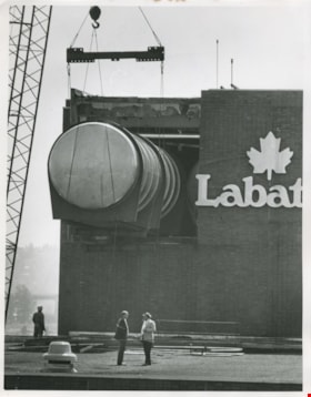
Construction of the Labatt Plant
https://search.heritageburnaby.ca/link/archivedescription58931
- Repository
- City of Burnaby Archives
- Date
- 1983
- Collection/Fonds
- Columbian Newspaper collection
- Description Level
- Item
- Physical Description
- 1 photograph : b&w ; 25 x 20.5 cm
- Scope and Content
- Photograph of the construction of the Labatt brewery. A crane is lifting a large pipe into the building and two men stand below, talking.
- Repository
- City of Burnaby Archives
- Date
- 1983
- Collection/Fonds
- Columbian Newspaper collection
- Physical Description
- 1 photograph : b&w ; 25 x 20.5 cm
- Description Level
- Item
- Record No.
- 480-1381
- Access Restriction
- No restrictions
- Reproduction Restriction
- Reproduce for fair dealing purposes only
- Accession Number
- 2009-01
- Scope and Content
- Photograph of the construction of the Labatt brewery. A crane is lifting a large pipe into the building and two men stand below, talking.
- Media Type
- Photograph
- Notes
- Title based on contents of photograph
- Note on verso reads: "PMT 100% / page B-3 / Burnaby Today"
Images

![Dugland C. Patterson Sr. beside his boiler, [1903 or 1904] thumbnail](/media/hpo/_Data/_Archives_Images/_Unrestricted/316/322-001.jpg?width=280)
Dugland C. Patterson Sr. beside his boiler
https://search.heritageburnaby.ca/link/archivedescription37116
- Repository
- City of Burnaby Archives
- Date
- [1903 or 1904]
- Collection/Fonds
- Burnaby Historical Society fonds
- Description Level
- Item
- Physical Description
- 1 photograph : sepia ; 10.5 x 8 cm, mounted on board 14 x 11 cm
- Scope and Content
- Photograph of Dugland Campbell Patterson Sr. standing by boiler he built; it was the largest built in New Westminster. He founded Vulcan Iron Works of New Westminister in 1903.
- Repository
- City of Burnaby Archives
- Date
- [1903 or 1904]
- Collection/Fonds
- Burnaby Historical Society fonds
- Subseries
- Patterson family subseries
- Physical Description
- 1 photograph : sepia ; 10.5 x 8 cm, mounted on board 14 x 11 cm
- Description Level
- Item
- Record No.
- 322-001
- Access Restriction
- No restrictions
- Reproduction Restriction
- No known restrictions
- Accession Number
- BHS1995-16
- Scope and Content
- Photograph of Dugland Campbell Patterson Sr. standing by boiler he built; it was the largest built in New Westminster. He founded Vulcan Iron Works of New Westminister in 1903.
- Subjects
- Buildings - Industrial - Factories
- Media Type
- Photograph
- Notes
- Title based on contents of photograph
- Note written by D.C. Patterson Jr. accompanying
Images
![Dugland C. Patterson Sr. beside his boiler, [1903 or 1904] thumbnail](/media/hpo/_Data/_Archives_Images/_Unrestricted/316/322-001.jpg)
![Easthope Brothers' Shop, [1905] (date of original), copied 1992 thumbnail](/media/hpo/_Data/_Archives_Images/_Unrestricted/315/315-515.jpg?width=280)
Easthope Brothers' Shop
https://search.heritageburnaby.ca/link/archivedescription37052
- Repository
- City of Burnaby Archives
- Date
- [1905] (date of original), copied 1992
- Collection/Fonds
- Burnaby Historical Society fonds
- Description Level
- Item
- Physical Description
- 1 photograph : b&w ; 8.8 x 12.7 cm print
- Scope and Content
- Photograph of the Easthope brothers' shop at Hamilton Street and Hastings Street, Vancouver. The business was begun as a marine engine manufacturer called Easthope and Sons by Ernest Easthope. Upon the death of Ernest Easthope the business was reorganized as Easthope Bros. by his sons. Identified…
- Repository
- City of Burnaby Archives
- Date
- [1905] (date of original), copied 1992
- Collection/Fonds
- Burnaby Historical Society fonds
- Subseries
- Burnaby Centennial Anthology subseries
- Physical Description
- 1 photograph : b&w ; 8.8 x 12.7 cm print
- Description Level
- Item
- Record No.
- 315-515
- Access Restriction
- No restrictions
- Reproduction Restriction
- No known restrictions
- Accession Number
- BHS1994-04
- Scope and Content
- Photograph of the Easthope brothers' shop at Hamilton Street and Hastings Street, Vancouver. The business was begun as a marine engine manufacturer called Easthope and Sons by Ernest Easthope. Upon the death of Ernest Easthope the business was reorganized as Easthope Bros. by his sons. Identified: (second from left) Ernest Easthope.
- Subjects
- Buildings - Industrial
- Media Type
- Photograph
- Notes
- Title based on contents of photograph
Images
![Easthope Brothers' Shop, [1905] (date of original), copied 1992 thumbnail](/media/hpo/_Data/_Archives_Images/_Unrestricted/315/315-515.jpg)
![Interior of Salmon Cannery, [1907] thumbnail](/media/hpo/_Data/_Archives_Images/_Unrestricted/126/133-015.jpg?width=280)
Interior of Salmon Cannery
https://search.heritageburnaby.ca/link/archivedescription34784
- Repository
- City of Burnaby Archives
- Date
- [1907]
- Collection/Fonds
- Burnaby Historical Society fonds
- Description Level
- Item
- Physical Description
- 1 photograph : b&w ; 12.7 x 17.7 cm
- Scope and Content
- Photograph of the interior of a salmon cannery in New Westminster. Two men are standing beside a number of fish on the floor. A box seen behind the man on the right reads in part, "Canning / salmon / [Wes]tminst[er]."
- Repository
- City of Burnaby Archives
- Date
- [1907]
- Collection/Fonds
- Burnaby Historical Society fonds
- Subseries
- Gerald Davy subseries
- Physical Description
- 1 photograph : b&w ; 12.7 x 17.7 cm
- Description Level
- Item
- Record No.
- 133-015
- Access Restriction
- No restrictions
- Reproduction Restriction
- No known restrictions
- Accession Number
- BHS1985-01
- Scope and Content
- Photograph of the interior of a salmon cannery in New Westminster. Two men are standing beside a number of fish on the floor. A box seen behind the man on the right reads in part, "Canning / salmon / [Wes]tminst[er]."
- Subjects
- Buildings - Industrial - Canneries
- Media Type
- Photograph
- Photographer
- Davy, Gerald
- Notes
- Title based on contents of photograph
Images
![Interior of Salmon Cannery, [1907] thumbnail](/media/hpo/_Data/_Archives_Images/_Unrestricted/126/133-015.jpg)
![Interior of the Burnaby Substation, [September 1908] thumbnail](/media/hpo/_Data/_Archives_Images/_Unrestricted/251/293-003.jpg?width=280)
Interior of the Burnaby Substation
https://search.heritageburnaby.ca/link/archivedescription36542
- Repository
- City of Burnaby Archives
- Date
- [September 1908]
- Collection/Fonds
- Burnaby Historical Society fonds
- Description Level
- Item
- Physical Description
- 1 photograph : b&w postcard ; 7.5 x 13 cm
- Scope and Content
- Photographic postcard of the interior of the British Columbia Electric Railway Company's Burnaby Substation that was built in 1903 and put into operation to receive and distribute power from the B.C.E.R. Buntzen Lake power dam. The electric lines came across the inlet at Barnet, along the Barnet-Ha…
- Repository
- City of Burnaby Archives
- Date
- [September 1908]
- Collection/Fonds
- Burnaby Historical Society fonds
- Subseries
- John DeForest subseries
- Physical Description
- 1 photograph : b&w postcard ; 7.5 x 13 cm
- Description Level
- Item
- Record No.
- 293-003
- Access Restriction
- No restrictions
- Reproduction Restriction
- No known restrictions
- Accession Number
- BHS1992-30
- Scope and Content
- Photographic postcard of the interior of the British Columbia Electric Railway Company's Burnaby Substation that was built in 1903 and put into operation to receive and distribute power from the B.C.E.R. Buntzen Lake power dam. The electric lines came across the inlet at Barnet, along the Barnet-Hastings Road to Sperling Avenue (built for this project and called Pole Line Road) and then south to this site at the corner of Griffiths and the old Central Park interurban line (later this section was called the Highland Park line). This substation was constructed to convert the alternating current being delivered from the Buntzen power plant to direct current for the operation of the tram cars operating on the Central Park interurban route. The new brick substation replaced the wood fed steam powered 1891 Powerhouse that operated south of this site, across the tracks until its closure on May 31,1905. It was demolised in the late 1920s. This brick substation originally known as the Burnaby Substation, eventually became known as the Newell Substation. The original brick building was replaced by a new structure in 1930, which was demolished in the 1960s in favour of the open field substation that continues to operate on the same site today at 7260 Griffiths Avenue.
- Subjects
- Buildings - Industrial - Powerhouses
- Media Type
- Photograph
- Notes
- Title based on contents of photograph
- Geographic Access
- Griffiths Avenue
- Historic Neighbourhood
- Edmonds (Historic Neighbourhood)
- Planning Study Area
- Stride Avenue Area
Images
![Interior of the Burnaby Substation, [September 1908] thumbnail](/media/hpo/_Data/_Archives_Images/_Unrestricted/251/293-003.jpg)
![Interior of the Burnaby Substation, [September 1908] thumbnail](/media/hpo/_Data/_Archives_Images/_Unrestricted/251/293-004.jpg?width=280)
Interior of the Burnaby Substation
https://search.heritageburnaby.ca/link/archivedescription36543
- Repository
- City of Burnaby Archives
- Date
- [September 1908]
- Collection/Fonds
- Burnaby Historical Society fonds
- Description Level
- Item
- Physical Description
- 1 photograph : b&w postcard ; 7.5 x 13 cm
- Scope and Content
- Photographic postcard of the interior of the British Columbia Electric Railway Company's Burnaby Substation that was built in 1903 and put into operation to receive and distribute power from the B.C.E.R. Buntzen Lake power dam. The electric lines came across the inlet at Barnet, along the Barnet-Ha…
- Repository
- City of Burnaby Archives
- Date
- [September 1908]
- Collection/Fonds
- Burnaby Historical Society fonds
- Subseries
- John DeForest subseries
- Physical Description
- 1 photograph : b&w postcard ; 7.5 x 13 cm
- Description Level
- Item
- Record No.
- 293-004
- Access Restriction
- No restrictions
- Reproduction Restriction
- No known restrictions
- Accession Number
- BHS1992-30
- Scope and Content
- Photographic postcard of the interior of the British Columbia Electric Railway Company's Burnaby Substation that was built in 1903 and put into operation to receive and distribute power from the B.C.E.R. Buntzen Lake power dam. The electric lines came across the inlet at Barnet, along the Barnet-Hastings Road to Sperling Avenue (built for this project and called Pole Line Road) and then south to this site at the corner of Griffiths and the old Central Park interurban line (later this section was called the Highland Park line). This substation was constructed to convert the alternating current being delivered from the Buntzen power plant to direct current for the operation of the tram cars operating on the Central Park interurban route. The new brick substation replaced the wood fed steam powered 1891 Powerhouse that operated south of this site, across the tracks until its closure on May 31,1905. It was demolised in the late 1920s. This brick substation originally known as the Burnaby Substation, eventually became known as the Newell Substation. The original brick building was replaced by a new structure in 1930, which was demolished in the 1960s in favour of the open field substation that continues to operate on the same site today at 7260 Griffiths Avenue.
- Subjects
- Buildings - Industrial - Powerhouses
- Media Type
- Photograph
- Notes
- Title based on contents of photograph
- Geographic Access
- Griffiths Avenue
- Historic Neighbourhood
- Edmonds (Historic Neighbourhood)
- Planning Study Area
- Stride Avenue Area
Images
![Interior of the Burnaby Substation, [September 1908] thumbnail](/media/hpo/_Data/_Archives_Images/_Unrestricted/251/293-004.jpg)

Interior of the Burnaby Substation
https://search.heritageburnaby.ca/link/archivedescription36544
- Repository
- City of Burnaby Archives
- Date
- 1907
- Collection/Fonds
- Burnaby Historical Society fonds
- Description Level
- Item
- Physical Description
- 1 photograph : sepia ; 12 x 17cm, mounted on board 22 x 27 cm
- Scope and Content
- Photograph of the interior of the British Columbia Electric Railway Company's Burnaby Substation that was built in 1903 and put into operation to receive and distribute power from the B.C.E.R. Buntzen Lake power dam. The electric lines came across the inlet at Barnet, along the Barnet-Hastings Road…
- Repository
- City of Burnaby Archives
- Date
- 1907
- Collection/Fonds
- Burnaby Historical Society fonds
- Subseries
- John DeForest subseries
- Physical Description
- 1 photograph : sepia ; 12 x 17cm, mounted on board 22 x 27 cm
- Description Level
- Item
- Record No.
- 293-005
- Access Restriction
- No restrictions
- Reproduction Restriction
- No known restrictions
- Accession Number
- BHS1992-30
- Scope and Content
- Photograph of the interior of the British Columbia Electric Railway Company's Burnaby Substation that was built in 1903 and put into operation to receive and distribute power from the B.C.E.R. Buntzen Lake power dam. The electric lines came across the inlet at Barnet, along the Barnet-Hastings Road to Sperling Avenue (built for this project and called Pole Line Road) and then south to this site at the corner of Griffiths and the old Central Park interurban line (later this section was called the Highland Park line). This substation was constructed to convert the alternating current being delivered from the Buntzen power plant to direct current for the operation of the tram cars operating on the Central Park interurban route. The new brick substation replaced the wood fed steam powered 1891 Powerhouse that operated south of this site, across the tracks until its closure on May 31,1905. It was demolised in the late 1920s. This brick substation originally known as the Burnaby Substation, eventually became known as the Newell Substation. The original brick building was replaced by a new structure in 1930, which was demolished in the 1960s in favour of the open field substation that continues to operate on the same site today at 7260 Griffiths Avenue.
- Subjects
- Buildings - Industrial - Powerhouses
- Media Type
- Photograph
- Notes
- Title based on contents of photograph
- Photographer's handwritten note (on the negative causing it to show) on recto of photograph reads: "Burnaby Substation/ B.C.E.R.C/O"
- Geographic Access
- Griffiths Avenue
- Historic Neighbourhood
- Edmonds (Historic Neighbourhood)
- Planning Study Area
- Stride Avenue Area
Images


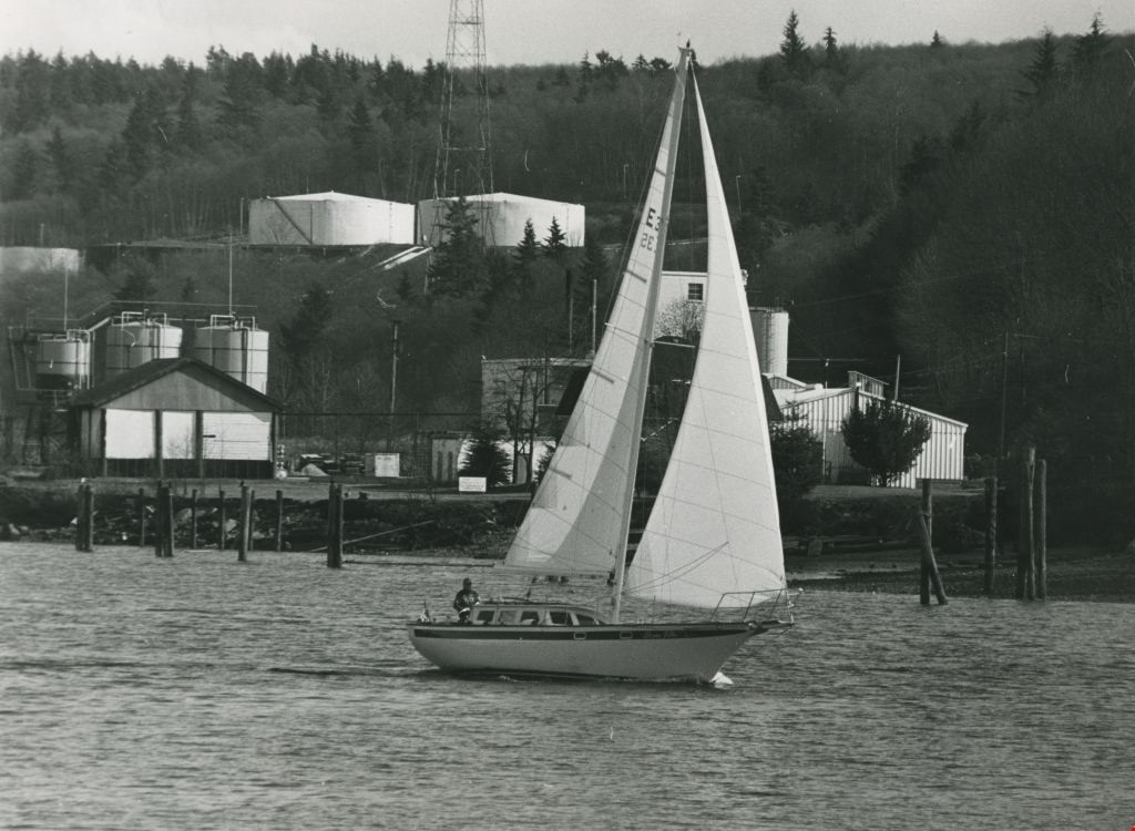
Man sailing around Barnet Inlet
https://search.heritageburnaby.ca/link/archivedescription58997
- Repository
- City of Burnaby Archives
- Date
- ca.1983
- Collection/Fonds
- Columbian Newspaper collection
- Description Level
- Item
- Physical Description
- 1 photograph : b&w ; 18.5 x 25.5 cm
- Scope and Content
- Photograph of a sailboat sailing in the Burrard Inlet, by Barnet Park. The hills and oil refinery are visible in the background.
- Repository
- City of Burnaby Archives
- Date
- ca.1983
- Collection/Fonds
- Columbian Newspaper collection
- Physical Description
- 1 photograph : b&w ; 18.5 x 25.5 cm
- Description Level
- Item
- Record No.
- 480-1407
- Access Restriction
- No restrictions
- Reproduction Restriction
- Reproduce for fair dealing purposes only
- Accession Number
- 2009-01
- Scope and Content
- Photograph of a sailboat sailing in the Burrard Inlet, by Barnet Park. The hills and oil refinery are visible in the background.
- Media Type
- Photograph
- Photographer
- Hodge, Craig
- Notes
- Title based on contents of photograph
- Photographer's stamp on verso
- Note on verso reads: "PMT 75% / page 4 / Burnaby Today"
- Geographic Access
- Burrard Inlet
- Barnet Marine Park
- Historic Neighbourhood
- Barnet (Historic Neighbourhood)
- Planning Study Area
- Burnaby Mountain Area
Images

Mills Burning at Barnet
https://search.heritageburnaby.ca/link/archivedescription38342
- Repository
- City of Burnaby Archives
- Date
- May 6, 1909
- Collection/Fonds
- Burnaby Historical Society fonds
- Description Level
- Item
- Physical Description
- 1 photograph : sepia postcard ; 8 x 13.4 cm
- Scope and Content
- Photographic postcard of the line of buildings burning at the North Pacific Lumber Company, with flames and smoke visible rising from the structures. A caption stamped at the top of the postcard reads: "Mills burning at Barnet BC. 1:30a.m. May 6th, 1909."
- Repository
- City of Burnaby Archives
- Date
- May 6, 1909
- Collection/Fonds
- Burnaby Historical Society fonds
- Subseries
- Charles Lee subseries
- Physical Description
- 1 photograph : sepia postcard ; 8 x 13.4 cm
- Description Level
- Item
- Record No.
- 411-001
- Access Restriction
- No restrictions
- Reproduction Restriction
- No known restrictions
- Accession Number
- BHS2000-13
- Scope and Content
- Photographic postcard of the line of buildings burning at the North Pacific Lumber Company, with flames and smoke visible rising from the structures. A caption stamped at the top of the postcard reads: "Mills burning at Barnet BC. 1:30a.m. May 6th, 1909."
- Names
- Barnet Mill
- Media Type
- Photograph
- Geographic Access
- Barnet Village
- Texaco Drive
- Street Address
- 8059 Texaco Drive
- Historic Neighbourhood
- Barnet (Historic Neighbourhood)
- Planning Study Area
- Burnaby Mountain Area
Images

Multi-Tenant Industrial Development / 5051 Still Creek Avenue
https://search.heritageburnaby.ca/link/archivedescription93722
- Repository
- City of Burnaby Archives
- Date
- 1989
- Collection/Fonds
- Grover, Elliott & Co. Ltd. fonds
- Description Level
- File
- Physical Description
- 24 photographs : col. negatives ; 35 mm
- Scope and Content
- Photographs of the exterior of the multi-tenant industrial complex located at 5051 Still Creek Avenue - an address that no longer exists.
- Repository
- City of Burnaby Archives
- Date
- 1989
- Collection/Fonds
- Grover, Elliott & Co. Ltd. fonds
- Physical Description
- 24 photographs : col. negatives ; 35 mm
- Description Level
- File
- Record No.
- 622-011
- Access Restriction
- No restrictions
- Reproduction Restriction
- No restrictions
- Accession Number
- 2017-39
- Scope and Content
- Photographs of the exterior of the multi-tenant industrial complex located at 5051 Still Creek Avenue - an address that no longer exists.
- Media Type
- Photograph
- Notes
- Transcribed title
- Title transcribed from original print envelope
- Residences were identified using notes on verso of accompanying prints
- Geographic Access
- Still Creek Avenue
- Planning Study Area
- Dawson-Delta Area