Narrow Results By
Person / Organization
- Barnes, Hannah Victoria "Girlie" Love 1
- BC Society of Model Engineers (BCSME) 1
- Brandrith, Martha Dorothy “Dot” Love 1
- Brassington, Wayne 1
- Buckle, Alice Love 1
- Burnaby Historical Society 2
- Burnaby Village Museum 8
- Burquest 1
- Central Park 1
- Chamberlain, Annie McKenzie 3
- Cohn, Dr. Daniel E. 1
- Cohn, Shirley 1
Mayor Bill Copeland
https://search.heritageburnaby.ca/link/archivedescription97391
- Repository
- City of Burnaby Archives
- Date
- 1992-2002
- Collection/Fonds
- Burnaby NewsLeader photograph collection
- Description Level
- File
- Physical Description
- 17 photographs (tiff) : b&w
- Scope and Content
- File contains photographs of or related to Mayor Bill Copeland from throughout his life and career (primarily 1992-1996) that were collected for a memorial feature. Photographs depict Copeland at Burnaby events acting as mayor at events and ceremonies, including: receiving the new city seal in 1992…
- Repository
- City of Burnaby Archives
- Date
- 1992-2002
- Collection/Fonds
- Burnaby NewsLeader photograph collection
- Physical Description
- 17 photographs (tiff) : b&w
- Description Level
- File
- Record No.
- 535-2766
- Access Restriction
- No restrictions
- Reproduction Restriction
- No restrictions
- Accession Number
- 2018-12
- Scope and Content
- File contains photographs of or related to Mayor Bill Copeland from throughout his life and career (primarily 1992-1996) that were collected for a memorial feature. Photographs depict Copeland at Burnaby events acting as mayor at events and ceremonies, including: receiving the new city seal in 1992; opening a new housing co-op on Bellwood Avenue; unveiling a plaque for Drs. Blythe and Violet Eagles in Deer Lake Park; and cutting the ribbon at the opening of the Station Square Save-On-Foods and the aftermath of the roof collapse.
- Media Type
- Photograph
- Notes
- Title based on caption
- Collected by editorial for use in a September 2002 issue of the Burnaby NewsLeader
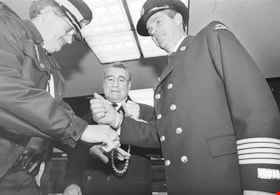
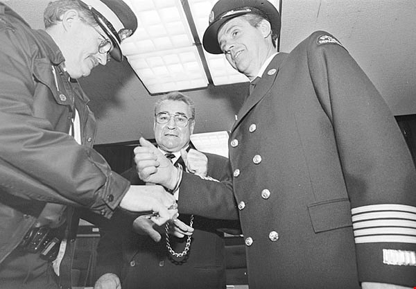
- Caption from metadata for 535-2766-1: "Bill Copeland and former Burnaby fire chief Wayne Brassington are "arrested" at City Hall to raise money for the Cancer Society, in 1996."
- Caption from metadata for 535-2766-2: "Bill Copeland is presented with a "birthday cake" celebrating Burnaby's centennial, in 1992, by Rose Vaughan, 101."
- Caption from metadata for 535-2766-3: "Bill Copeland tries out the computer touch screen at the grand opening of the newly refurbished CW Parker Carousel, at Burnaby Village Museum in April, 1995."
- Caption from metadata for 535-2766-4: "Bill Copeland is presented with Burnaby's new city seal by former premier, Mike Harcourt, part of the city's centennial celebration, in 1992."
- Caption from metadata for 535-2766-6: "Mayor Bill and the late Rudy Spence toast Ellen Betts at a diner honoring her longtime volunteer service with the Burnaby Arts Council, in 1995."
- Caption from metadata for 535-2766-7: "Copeland is congratulated on his re-election as Mayor, in 1993."
- Caption from metadata for 535-2766-8: "Mayor Bill laces up to promote a fitness challenge at Burnaby City Hall, in 1994."
- Caption from metadata for 535-2766-9: "Mayor Bill helps work the phones to promote a Chamber of Commerce membership drive, in 1993."
- Caption from metadata for 535-2766-10: "Mayor Bill helps unveil a plaque honoring doctors Blythe and Violet Eagles, at Deer Lake Park, in 1994."
- Caption from metadata for 535-2766-11: "Mayor Bill opens a new housing co-op on Bellwood Ave., with help from Hedy Fry and former MLA, Barry Gray."
- Caption from metadata for 535-2766-12: "Mayor Bill Copeland briefs the media after the Save-On Foods collapse at Station Square."
- Caption from metadata for 535-2766-13: "Mayor Bill Copeland, Jim Pattison, and other local dignitaries, are all smiles at the official opening of the new Save-On Foods at Station Square. But shortly after the ribbon-cutting ceremony, the new store's roof collapsed."
- Caption from metadata for 535-2766-15: "Mayor Bill tries out a vegetarian plate at the City Hall cafeteria, in 1996."
- Caption from metadata for 535-2766-16: "Bill Copeland celebrates his victory in a water pistol "showdown" against rival mayor, the late Len Trabouley, from Port Coquitlam, in 1992."
- Caption from metadata for 535-2766-17: "Even after he was confined to a wheelchair, following his illness, Bill Copeland continued to attend various city functions."
Images
Mrs. James Richard (Dick) Whiting
https://search.heritageburnaby.ca/link/museumdescription9848
- Repository
- Burnaby Village Museum
- Date
- [1947] (date of original)-[1998]
- Collection/Fonds
- Burnaby Village Museum fonds
- Description Level
- File
- Physical Description
- 2 cm of textual records
- Scope and Content
- File consists of copies of biographical and genealogical information and photocopies of photographs along with interview notes (November 6, 1997). File also includes a newspaper clipping "She was Named for the Municipality / Burnaby's first baby visiting from England" about Mrs. C.A. Whiting who wa…
- Repository
- Burnaby Village Museum
- Collection/Fonds
- Burnaby Village Museum fonds
- Series
- Jesse Love farmhouse series
- Subseries
- Love farmhouse research files subseries
- Description Level
- File
- Physical Description
- 2 cm of textual records
- Scope and Content
- File consists of copies of biographical and genealogical information and photocopies of photographs along with interview notes (November 6, 1997). File also includes a newspaper clipping "She was Named for the Municipality / Burnaby's first baby visiting from England" about Mrs. C.A. Whiting who was the first white baby born in Burnaby ca. 1893. File includes information obtained from Florence Edna Whiting (Mrs. James Richard Whiting) who is the daughter in law of Annie (Love) Whiting and Wallace Whiting. Mrs. James Richard Whiting married Richard Whiting.
- Accession Code
- BV018.41.59
- Access Restriction
- Subject to FIPPA
- Reproduction Restriction
- Reproductions subject to FIPPA
- Date
- [1947] (date of original)-[1998]
- Media Type
- Textual Record
- Notes
- Transcribed title
People files - Jesse and Martha Love
https://search.heritageburnaby.ca/link/archivedescription66321
- Repository
- City of Burnaby Archives
- Date
- 1989-1998
- Collection/Fonds
- Burnaby Historical Society fonds
- Description Level
- File
- Physical Description
- 1 file of textual records
- Scope and Content
- File consists of information pages pertaining to Jesse and Martha Love and their farmhouse (now a part of the Burnaby Village Museum).
- Repository
- City of Burnaby Archives
- Date
- 1989-1998
- Collection/Fonds
- Burnaby Historical Society fonds
- Subseries
- People files subseries
- Physical Description
- 1 file of textual records
- Description Level
- File
- Record No.
- 42754
- Accession Number
- BHS2007-04
- Scope and Content
- File consists of information pages pertaining to Jesse and Martha Love and their farmhouse (now a part of the Burnaby Village Museum).
- Media Type
- Textual Record
- Notes
- Title based on contents of file
Phoebe Feedham (nee Love)
https://search.heritageburnaby.ca/link/museumdescription9859
- Repository
- Burnaby Village Museum
- Date
- 1987 (date of original)-[1998]
- Collection/Fonds
- Burnaby Village Museum fonds
- Description Level
- File
- Physical Description
- 1 cm of textual records
- Scope and Content
- File consists of copies of marriage, birth and death certificates along with copies of biographical information from Pioneer Tales and notes about Phoebe Feedham (nee Love) who was the daughter of Jesse and Martha Love and was married to William Charles Feedham.
- Repository
- Burnaby Village Museum
- Collection/Fonds
- Burnaby Village Museum fonds
- Series
- Jesse Love farmhouse series
- Subseries
- Love farmhouse research files subseries
- Description Level
- File
- Physical Description
- 1 cm of textual records
- Scope and Content
- File consists of copies of marriage, birth and death certificates along with copies of biographical information from Pioneer Tales and notes about Phoebe Feedham (nee Love) who was the daughter of Jesse and Martha Love and was married to William Charles Feedham.
- Accession Code
- BV018.41.70
- Access Restriction
- Subject to FIPPA
- Reproduction Restriction
- Reproductions subject to FIPPA
- Date
- 1987 (date of original)-[1998]
- Media Type
- Textual Record
- Notes
- Title based on content of file
Photocopies of Albert Parker photographs
https://search.heritageburnaby.ca/link/museumdescription9954
- Repository
- Burnaby Village Museum
- Date
- [1893-1960] (date of originals), copied 1998
- Collection/Fonds
- Burnaby Village Museum fonds
- Description Level
- File
- Physical Description
- 1 file of textual records (photocopies)
- Scope and Content
- File consists of photocopies from loose photographs owned by Albert Parker with notes that were added by Lisa Langlet and Colin Stevens as they went through the content with Albert. Photographs include: members of the Hughes and Parker families; early exterior views of the Love farmhouse; William P…
- Repository
- Burnaby Village Museum
- Collection/Fonds
- Burnaby Village Museum fonds
- Series
- Jesse Love farmhouse series
- Subseries
- Love family photographs subseries
- Description Level
- File
- Physical Description
- 1 file of textual records (photocopies)
- Scope and Content
- File consists of photocopies from loose photographs owned by Albert Parker with notes that were added by Lisa Langlet and Colin Stevens as they went through the content with Albert. Photographs include: members of the Hughes and Parker families; early exterior views of the Love farmhouse; William Parker in the garden of the Love farmhouse; a postcard with the title "Cariboo Rd. / Burnaby"; Silver anniversary card to Sarah (nee Love) and William Parker with names of family members and friends; Sarah Parker (1940s); Phoebe (nee Love) and William Feedham; music "The Violet / For Mrs. Will Parker.../ Christmas 1938 / words by Jane Taylor / Music by W.R. Lowe (neighbour to the Parkers when they lived on Newcombe Street); tennis court on the grounds of the farmhouse on Cumberland and a wedding cake in the parlour of the farmhouse at Frank Charles Stanley and Esther Love's wedding.
- History
- Sarah Parker (nee Love) and William Parker lived in the Jesse Love farmhouse with their children: Albert, Bill and Elsie from 1925. Elsie married John Hughes in 1942 and they had three children; Brent, Anne and John. Sarah Parker sold the Love farmhouse to her daughter Elsie and husband John Hughes in 1966. Elsie and John Hughes had four children; John Jr., Ann, Brent and Merle. They lived in the Love farmhouse with their son Brent until 1971.
- Names
- Parker, Albert "Bert"
- Hughes, Elsie Roberta Parker
- Parker, Sarah Maria Love
- Parker, Margaret "Peggy"
- Accession Code
- BV018.41.206
- Access Restriction
- No restrictions
- Reproduction Restriction
- May be restricted by third party rights
- Date
- [1893-1960] (date of originals), copied 1998
- Media Type
- Textual Record
- Notes
- Title based on content of file
Photocopy of Albert Parker album
https://search.heritageburnaby.ca/link/museumdescription9951
- Repository
- Burnaby Village Museum
- Date
- [1900-1970] (date of originals), copied 1998
- Collection/Fonds
- Burnaby Village Museum fonds
- Description Level
- File
- Physical Description
- 1 file of textual records (photocopies)
- Scope and Content
- File consists of photocopies from a photograph album owned by Albert Parker with notes that were added by Lisa Langlet as she went through the content with Albert. Photos mostly pertain to the Parker and Hughes families as well as some photos of the Love family members and the Love farmhouse includ…
- Repository
- Burnaby Village Museum
- Collection/Fonds
- Burnaby Village Museum fonds
- Series
- Jesse Love farmhouse series
- Subseries
- Love family photographs subseries
- Description Level
- File
- Physical Description
- 1 file of textual records (photocopies)
- Scope and Content
- File consists of photocopies from a photograph album owned by Albert Parker with notes that were added by Lisa Langlet as she went through the content with Albert. Photos mostly pertain to the Parker and Hughes families as well as some photos of the Love family members and the Love farmhouse including: Sarah (nee Love) and her husband William Parker; children of Sarah and William Parker; sister Elsie (nee Parker) Hughes and family in Ontario; Late 1920-1930 exterior photos of the Love farmhouse in the winter; Annie (nee Love) and husband Flash Whiting; tennis on the grounds of the Love farmhouse; Dot/Dorothy (nee Love) Brandrith and Minnie (nee Love) McKenzie; Hughes children and grandfather William Parker at Love farmhouse; Bill Parker and his wife May in the Air Force and BC coast; Elsie and John Hughes wedding day (1942); Jesse Love; John Hughes and family at the farmhouse at Christmas; Love children and spouses; camping with Annie (nee Love) Whiting; Henry Love; Sarah (nee Love) Parker and her sister Annie (nee Love) Whiting with infants; Albert and his sister Elsie Parker; Parker family old home on Newcombe Street in Burnaby; Love family and friends camping; Postcards from England; William Parker's death notice; Jesse Love and dog; Love family and friends in car; William and Phoebe (nee Love) Feedham and their boat FeBe; tennis court with family and friends; Ester (nee Love) Stanley and Robert Love in WWI uniform.
- History
- Sarah Parker (nee Love) and William Parker lived in the Jesse Love farmhouse with their children: Albert, Bill and Elsie from 1925. Elsie married John Hughes in 1942 and they had three children; Brent, Anne and John. Sarah Parker sold the Love farmhouse to her daughter Elsie and husband John Hughes in 1966. Elsie and John Hughes had four children; John Jr., Ann, Brent and Merle. They lived in the Love farmhouse with their son Brent until 1971.
- Accession Code
- BV018.41.203
- Access Restriction
- No restrictions
- Reproduction Restriction
- May be restricted by third party rights
- Date
- [1900-1970] (date of originals), copied 1998
- Media Type
- Textual Record
- Notes
- Title based on content of file
Photocopy of Albert Parker album
https://search.heritageburnaby.ca/link/museumdescription9952
- Repository
- Burnaby Village Museum
- Date
- [1940-1960] (date of originals), copied 1998
- Collection/Fonds
- Burnaby Village Museum fonds
- Description Level
- File
- Physical Description
- 1 file of textual records (photocopies)
- Scope and Content
- File consists of photocopies from a photograph album owned by Albert Parker with notes that were added by Lisa Langlet as she went through the content with Albert. Photos mostly pertain to Albert Parker and family along with a few of the Hughes family and the Love farmhouse including: Albert Park…
- Repository
- Burnaby Village Museum
- Collection/Fonds
- Burnaby Village Museum fonds
- Series
- Jesse Love farmhouse series
- Subseries
- Love family photographs subseries
- Description Level
- File
- Physical Description
- 1 file of textual records (photocopies)
- Scope and Content
- File consists of photocopies from a photograph album owned by Albert Parker with notes that were added by Lisa Langlet as she went through the content with Albert. Photos mostly pertain to Albert Parker and family along with a few of the Hughes family and the Love farmhouse including: Albert Parker and his wife Margaret (Peggy); interior of Jesse Love farmhouse dining room (ca. 1940); exterior of Love farmhouse with tall grass; Petulla bridge; Rosie Whiting with children; Sarah (nee Love) Parker and husband William; interior of Love farmhouse kitchen: Sarah Parker at the kitchen sink and peeling potatoes; Albert Parker in police uniform; Stanley Park (ca. 1950); Parker family relations; Cumberland Road prior to paving; members of the Brandrith family; William Parker with shovel in front of Love farmhouse barn; cherry tree at side of Love farmhouse; Elsie (nee Parker) Hughes; John Hughes; Albert Parker with hiking club; Vancouver coastline; Mary Brandrith and street photo of Albert Parker.
- History
- Sarah Parker (nee Love) and William Parker lived in the Jesse Love farmhouse with their children: Albert, Bill and Elsie from 1925. Elsie married John Hughes in 1942 and they had three children; Brent, Anne and John. Sarah Parker sold the Love farmhouse to her daughter Elsie and husband John Hughes in 1966. Elsie and John Hughes had four children; John Jr., Ann, Brent and Merle. They lived in the Love farmhouse with their son Brent until 1971.
- Names
- Parker, Albert "Bert"
- Hughes, Elsie Roberta Parker
- Parker, Sarah Maria Love
- Parker, Margaret "Peggy"
- Accession Code
- BV018.41.204
- Access Restriction
- No restrictions
- Reproduction Restriction
- May be restricted by third party rights
- Date
- [1940-1960] (date of originals), copied 1998
- Media Type
- Textual Record
- Notes
- Title based on content of file
Photocopy of Albert Parker album
https://search.heritageburnaby.ca/link/museumdescription9953
- Repository
- Burnaby Village Museum
- Date
- [1900-1960] (date of originals), copied 1998
- Collection/Fonds
- Burnaby Village Museum fonds
- Description Level
- File
- Physical Description
- 1 file of textual records (photocopies)
- Scope and Content
- File consists of photocopies from a photograph album owned by Albert Parker with notes that were added by Lisa Langlet as she went through the content with Albert. Photocopies of photos mostly pertain to Albert Parker and family along with a few of the Love family and farmhouse including: Albert's …
- Repository
- Burnaby Village Museum
- Collection/Fonds
- Burnaby Village Museum fonds
- Series
- Jesse Love farmhouse series
- Subseries
- Love family photographs subseries
- Description Level
- File
- Physical Description
- 1 file of textual records (photocopies)
- Scope and Content
- File consists of photocopies from a photograph album owned by Albert Parker with notes that were added by Lisa Langlet as she went through the content with Albert. Photocopies of photos mostly pertain to Albert Parker and family along with a few of the Love family and farmhouse including: Albert's early childhood; Albert's cousins from his mother's side (the Stanleys); Albert's cousins from his father's side (the Parkers); exterior of Love farmhouse; house at 1390 Newcombe Street; Love farmhouse porch and garden with Love family members (ca. 1900); swing at farmhouse; William Parker's half brothers and their families (Deacon); Bill Parker and his family at Christmas in the farmhouse; Pioneer day with Sarah (Love) and William Parker dressed in costume; Albert and Margaret (Peggy) Parker; Elsie (nee Parker) Hughes and family including children's class photos and Love farmhouse in winter.
- History
- Sarah Parker (nee Love) and William Parker lived in the Jesse Love farmhouse with their children: Albert, Bill and Elsie from 1925. Elsie married John Hughes in 1942 and they had three children; Brent, Anne and John. Sarah Parker sold the Love farmhouse to her daughter Elsie and husband John Hughes in 1966. Elsie and John Hughes had four children; John Jr., Ann, Brent and Merle. They lived in the Love farmhouse with their son Brent until 1971.
- Names
- Parker, Albert "Bert"
- Hughes, Elsie Roberta Parker
- Parker, Sarah Maria Love
- Parker, Margaret "Peggy"
- Accession Code
- BV018.41.205
- Access Restriction
- No restrictions
- Reproduction Restriction
- May be restricted by third party rights
- Date
- [1900-1960] (date of originals), copied 1998
- Media Type
- Textual Record
- Notes
- Title based on content of file
Royal Bank building research and correspondence
https://search.heritageburnaby.ca/link/museumdescription18549
- Repository
- Burnaby Village Museum
- Date
- 1974-1993
- Collection/Fonds
- Burnaby Village Museum fonds
- Description Level
- File
- Physical Description
- 2 cm of textual records
- Scope and Content
- File consists of research and correspondence pertaining to the history of the Royal Bank along with information and correspondence regarding the Royal Bank management plan; restoration; construction of a basement; press releases and invitation lists for the opening in May 1977.
- Repository
- Burnaby Village Museum
- Collection/Fonds
- Burnaby Village Museum fonds
- Series
- Royal Bank exhibit series
- Description Level
- File
- Physical Description
- 2 cm of textual records
- Scope and Content
- File consists of research and correspondence pertaining to the history of the Royal Bank along with information and correspondence regarding the Royal Bank management plan; restoration; construction of a basement; press releases and invitation lists for the opening in May 1977.
- Names
- Royal Bank of Canada
- Accession Code
- BV022.1.3
- Access Restriction
- Subject to FIPPA
- Reproduction Restriction
- Reproductions subject to FIPPA
- Date
- 1974-1993
- Media Type
- Textual Record
- Notes
- Title based on contents of file
Sarah Marie Parker (nee Love)
https://search.heritageburnaby.ca/link/museumdescription9856
- Repository
- Burnaby Village Museum
- Date
- 1913 (date of original)-[1998]
- Collection/Fonds
- Burnaby Village Museum fonds
- Description Level
- File
- Physical Description
- 1 cm of textual records
- Scope and Content
- File consists of several pages of biographical and genealogical information about Sarah Marie Parker (nee Love). File includes printed "Family Group Sheets" pertaining to the Love family. Sarah Marie Parker is the daughter of Jesse and Martha Love and was married to William Michael Norton Parker.
- Repository
- Burnaby Village Museum
- Collection/Fonds
- Burnaby Village Museum fonds
- Series
- Jesse Love farmhouse series
- Subseries
- Love farmhouse research files subseries
- Description Level
- File
- Physical Description
- 1 cm of textual records
- Scope and Content
- File consists of several pages of biographical and genealogical information about Sarah Marie Parker (nee Love). File includes printed "Family Group Sheets" pertaining to the Love family. Sarah Marie Parker is the daughter of Jesse and Martha Love and was married to William Michael Norton Parker.
- Names
- Parker, Sarah Maria Love
- Accession Code
- BV018.41.67
- Access Restriction
- Subject to FIPPA
- Reproduction Restriction
- Reproductions subject to FIPPA
- Date
- 1913 (date of original)-[1998]
- Media Type
- Textual Record
- Scan Date
- 2019-05-21
- Notes
- Title based on content of file
Shirley Dack (nee Whiting)
https://search.heritageburnaby.ca/link/museumdescription9849
- Repository
- Burnaby Village Museum
- Date
- [1997]
- Collection/Fonds
- Burnaby Village Museum fonds
- Description Level
- File
- Physical Description
- 2 pgs of textual records
- Scope and Content
- File consists of copies of a family tree of biographical notes about Shirley Dack (nee Whiting). Shirley Dack is the grandaughter of Wallace (Flash) Whiting and Annie Whiting (nee Love)
- Repository
- Burnaby Village Museum
- Collection/Fonds
- Burnaby Village Museum fonds
- Series
- Jesse Love farmhouse series
- Subseries
- Love farmhouse research files subseries
- Description Level
- File
- Physical Description
- 2 pgs of textual records
- Scope and Content
- File consists of copies of a family tree of biographical notes about Shirley Dack (nee Whiting). Shirley Dack is the grandaughter of Wallace (Flash) Whiting and Annie Whiting (nee Love)
- Names
- Dack, Shirley Whiting
- Accession Code
- BV018.41.60
- Access Restriction
- Subject to FIPPA
- Reproduction Restriction
- Reproductions subject to FIPPA
- Date
- [1997]
- Media Type
- Textual Record
- Notes
- Title based on content of file
![Subdivision plans in New Westminster District Group 1 – Burnaby
, [1882-1910] thumbnail](/media/hpo/_Data/_BVM_Cartographic_Material/1977/1977_0093_0013a_001.jpg?width=280)
Subdivision plans in New Westminster District Group 1 – Burnaby
https://search.heritageburnaby.ca/link/museumdescription6982
- Repository
- Burnaby Village Museum
- Date
- [1882-1910]
- Collection/Fonds
- Burnaby Village Museum Map collection
- Description Level
- File
- Physical Description
- 4 plans : blueprint on paper mounted on 2 sides of cardboard 76 x 102 cm
- Scope and Content
- Item consists of a large board of two New Westminster District Gp 1 - subdivision plans mounted on one side and two New Westminster District Gp 1 - subdivision plans mounted on the other side. Side A: 1. Blueprint "Plan / of the / Subdivision / of / Lot 98 / G.1, N.W.D. / Scale 4 chs = 1 in. / …
- Repository
- Burnaby Village Museum
- Collection/Fonds
- Burnaby Village Museum Map collection
- Description Level
- File
- Physical Description
- 4 plans : blueprint on paper mounted on 2 sides of cardboard 76 x 102 cm
- Material Details
- Scales [between 1:1584 and 1:3168]
- Index number on edge of board reads: "13"
- Scope and Content
- Item consists of a large board of two New Westminster District Gp 1 - subdivision plans mounted on one side and two New Westminster District Gp 1 - subdivision plans mounted on the other side. Side A: 1. Blueprint "Plan / of the / Subdivision / of / Lot 98 / G.1, N.W.D. / Scale 4 chs = 1 in. / Map No 573" (Geographic location: Burnaby) 2. Blueprint "Plan / of Subdivision of / Lot 157 / Gr.1, New. West. Dist. / Scale 3 chs = 1 in. / Map No. 612". (Geographic location: Burnaby) Side B: 1. Blueprint "Plan / of Subdivision / of a Portion of / Lot 90 / Group One / New Westminster Dist. / Scale 2 chs = 1 in. / Map No. 555". Plan is signed by "Jno Strathern [sic]_P.L.S."n (Geographic location: Burnaby) 2. Blueprint "Subdivision of Lot 31, Group 1. / New Westminster District / As Amended by Order of Court / 1st Sept. 1882 and Numbered 847 / Scale 4 chs = 1in. / Map No 80" (Geographic location: Burnaby)
- Creator
- Stathern, John
- Accession Code
- HV977.93.13
- Access Restriction
- No restrictions
- Reproduction Restriction
- No known restrictions
- Date
- [1882-1910]
- Media Type
- Cartographic Material
- Historic Neighbourhood
- Alta Vista (Historic Neighbourhood)
- Planning Study Area
- Richmond Park Area
- Lakeview-Mayfield Area
- Scan Resolution
- 300
- Scale
- 72
- Notes
- Title based on contents of file
- Scale is measured in chains. (One chain equals 792 inches)
- The term "Lot" can also refer to a "District Lot”
Images
![Subdivision plans in New Westminster District Group 1 – Burnaby
, [1882-1910] thumbnail](/media/hpo/_Data/_BVM_Cartographic_Material/1977/1977_0093_0013a_001.jpg)

![Survey and Subdivision plans in New Westminster District Group 1 – Burnaby
, [1861]-[1910] thumbnail](/media/hpo/_Data/_BVM_Cartographic_Material/1977/1977_0093_0019a_001.jpg?width=280)
Survey and Subdivision plans in New Westminster District Group 1 – Burnaby
https://search.heritageburnaby.ca/link/museumdescription6988
- Repository
- Burnaby Village Museum
- Date
- [1861]-[1910]
- Collection/Fonds
- Burnaby Village Museum Map collection
- Description Level
- File
- Physical Description
- 14 plans : 3 plans : black ink on paper hand col. + 7 plans : black ink on paper + 4 plans : graphite on paper mounted on 2 sides of cardboard 76 x 102 cm
- Scope and Content
- Item consists of a large board of four New Westminster District Gp 1 - subdivision plans mounted on one side and ten New Westminster District Gp 1 - subdivision plans mounted on the other side. Side A: 1. "Plan /of / Lots 166A, 166 and 167 /, Gr.1, N.W.D. / Showing Misconstructed Roads in Gree…
- Repository
- Burnaby Village Museum
- Collection/Fonds
- Burnaby Village Museum Map collection
- Description Level
- File
- Physical Description
- 14 plans : 3 plans : black ink on paper hand col. + 7 plans : black ink on paper + 4 plans : graphite on paper mounted on 2 sides of cardboard 76 x 102 cm
- Material Details
- Scales [between 1:2376 and 1:7920]
- Index number on edge of board reads: "19"
- Scope and Content
- Item consists of a large board of four New Westminster District Gp 1 - subdivision plans mounted on one side and ten New Westminster District Gp 1 - subdivision plans mounted on the other side. Side A: 1. "Plan /of / Lots 166A, 166 and 167 /, Gr.1, N.W.D. / Showing Misconstructed Roads in Green / 5 chs = 1 in.". (plan is drawn in black ink and hand coloured in red, green and orange ink). A section in the centre of the plan is coloured in red ink and identified as "C.S. Richmond" running from the North Arm of Fraser River to Wiggins Road and divided by "New Wiggins Rd. (as gazetted)" (coloured in orange ink) and two"Constructed Road(s)" (coloured in green ink). Plan is initialed by: "RB" [sic] (in blue pencil crayon) 2. Plan of / Subdivision of / Lot 166 / Group One / New Westminster District / Scale 4 chs = 1 in. / Map No 524". Plan is drawn in graphite and signed by "Surrig [sic] Welhams [sic] / P.L.S." Plan is initialed by: "RB" [sic] (in blue pencil crayon) 3. Plan of "Survey / of Highway / For / Burnaby Council / in / Lots 13 _14 / Group One / Scale 4 chs = 1 in." Signed by "Albert J. Hill, P.L.S." Caribou Street and Caribou Road run through the centre of the plan. Plan is stamped: "Albert J. Hill, Civil Engineer / and / Provincial Land Surveyor, / New Westminster, / B.C.". Plan is initialed by: "RB" [sic] (in blue pencil crayon) 4. A Plan of Lots 166A, 166 and 167, Group One, New Westminster District (drawn in graphite). A section in the centre of the plan is identified as "C.S. Richmond" running from the North Arm of Fraser River and divided by "New Wiggins Rd. (as gazetted)" and two "Constructed Road(s)". Plan is initialed by: "RB" [sic] (in blue pencil crayon) Side B: 1. Small plan drawn in black ink (no title) identifying lots north of the "North Arm" of the Fraser River. Lots identified include: Lot 99, Lot 98, Lot 157, Lot 158, Lot 163, Lot 162, Lot 159, Lot 163, Lot 162, Lot 165, Lot 166A, Lot 155B, Lot 155A and Lot 159. "Scale 40 chains to one inch" . Plan is initialed by: "RB" [sic] (in blue pencil crayon) (Geographic location: Burnaby) 2. Small plan drawn in black ink (no title) identifying lots north of the North Arm of the Fraser River as "Lots 155, 155A, 155B, 155C, 162, 163, 164, 165, 166A and 167". Plan is initialed by: "RB" [sic] (in blue pencil crayon) (Geographic location: Burnaby) 3. Small plan drawn in black ink (no title) which identifies "Lot 151 / Reserve/ for / Race Course"; "Reserve / 64 A / L. 152 G.1"; and other Lots: 32, 33, 34, 35, 36, 38, 39. The plan is signed "Surveyor G.Turn [sic] July / 61 / from Vol 40 R.L. notes [sic]" Plan is stamped: "Albert J. Hill, Civil Engineer / and / Provincial Land Surveyor, / New Westminster, / B.C." Plan is initialed by: "RB" [sic] (in blue pencil crayon) (Geographic location: Burnaby) 4. Small plan drawn in black in with faded red colouring on centre lot identified as "Lot 34" running north from "Vancouver Road" . Plan is stamped: "Albert J. Hill, Civil Engineer / and / Provincial Land Surveyor, / New Westminster, / B.C." Plan is initialed by: "RB" [sic] (in blue pencil crayon) (Geographic location: Burnaby) 5. Plan drawn in graphite and identified as "Lot 98, Gr.1," along with the intials "RB" [sic] (both are handwritten in blue crayon pencil on top of plan) The B.C.E.Railway is identified running through the plan along with Jubilee Road and Royal Oak Road. The plan is signed with the name "Wm. Murray" and the Plan is stamped: "Albert J. Hill, Civil Engineer / and / Provincial Land Surveyor, / New Westminster, / B.C.". (Geographic location: Burnaby) 6. Plan drawn in graphite identified as "Port Lot 13, Gr.1" along with the intials "RB" [sic] (both are handwritten in blue crayon pencil on top of plan) Plan is stamped: "Albert J. Hill, Civil Engineer / and / Provincial Land Surveyor, / New Westminster, / B.C.". (Geographic location: Burnaby) 7.Plan drawn in black ink and identified as "Lot 98 G.1" along with the intials "RB" [sic] (both are handwritten in blue crayon pencil on top of plan). A "Road Reservation" is identified running north between "Electric Tramway" and connecting with "Royal Oak Road". Plan is stamped: "Albert J. Hill, Civil Engineer / and / Provincial Land Surveyor, / New Westminster, / B.C." (Geographic location: Burnaby) 8. Plan drawn in black ink and divided into two sections, the upper plan is identified as "Portion / Lots 100 / area / 101, Gr.1" and the lower plan is identified as "Portion L. 3 G. 1" along with the intials "RB" [sic] (these identifiers are handwritten in blue crayon pencil on top of the plan). Portions of Lot 100 and Lot 101 are each divided into 6 sections and the Portion of Lot 3 plan is divided into 24 sections. The plan includes a note in black ink that reads: " Received from Wm Fromme [sic] / from Wm. Trapp / Nov. 28, 1895 / A. J. T...[sic]". (Geographic location: Burnaby) 9. Plan drawn in black ink (no title) identifying soil, buildings and geographic features in southern Burnaby. The plan is bordered by "New Westminster City" (Tenth Avenue and DL 172) to the south east and DL 173 to the south, DL 158 to the west and the B.C.E. Tramway to the north. Plan includes District Lots: 155A, 158, 159, 171, 160, 53 and 95 and identifies soil, marshland and ravines throughout. Plan identifies the following features: a "Team Road" running through Lots 158 and 159 along with "Fair Orchard Soil / Even Surface Throughout / No Ravines", "Gravel and Shingle" (bottom of Lot 158), "North Arm Road" crossing "Byrne Road" and connecting with "Power House Road" which runs north to connect with "Highland Park Station" and the B.C.E. Tramway, "Power Ho" in the northeast corner of DL 160, a "Brook" connected with a "Deep Ravine" running between DL 53, DL 95 and DL 160 along with "Good Soil" and "Fair Orchard Soil" identified nearby in DL 95. Scale is identified as "10 chs = 1 in." Plan is stamped: "Albert J. Hill, Civil Engineer / and / Provincial Land Surveyor, / New Westminster, / B.C." Plan is initialed by: "RB" [sic] (in blue pencil crayon) (Geographic location: Burnaby) 10. Plan drawn in black ink (no title) with Burnaby Lake and Deer Lake at the centre. The plan is bordered by the following District Lots identified as: 117, 118 and 68 to the west, Lots 80, 79 and 85 to the southwest, Lots 11, 13, and 1 (City of New Westminster) to the south east, the North Road boundary to the east and Lots 8, 56, 57, 59, and 136 to the North. The lower right hand corner of the plan has a small inset which reads: "Burnaby Lake" and "Page 19 R.B. Notes". Plan is initialed by: "RB" [sic] (in blue pencil crayon) (Geographic location: Burnaby)
- Creator
- Hill, Albert James
- Accession Code
- HV977.93.19
- Access Restriction
- No restrictions
- Reproduction Restriction
- No known restrictions
- Date
- [1861]-[1910]
- Media Type
- Cartographic Material
- Scan Resolution
- 300
- Scale
- 72
- Notes
- Title based on contents of file
- Scale is measured in chains. (One chain equals 792 inches)
- The term "Lot" can also refer to a "District Lot”
- Some plans are stamped: "Albert J. Hill, Civil Engineer / and / Provincial Land Surveyor, / New Westminster, / B.C." and intialed: "RB" [sic]
Images
![Survey and Subdivision plans in New Westminster District Group 1 – Burnaby
, [1861]-[1910] thumbnail](/media/hpo/_Data/_BVM_Cartographic_Material/1977/1977_0093_0019a_001.jpg)

![Survey and Subdivision plans in New Westminster District Group 1 – Burnaby, Port Moody, [1862-1908] thumbnail](/media/hpo/_Data/_BVM_Cartographic_Material/1977/1977_0093_0026a_001.jpg?width=280)
Survey and Subdivision plans in New Westminster District Group 1 – Burnaby, Port Moody
https://search.heritageburnaby.ca/link/museumdescription6995
- Repository
- Burnaby Village Museum
- Date
- [1862-1908]
- Collection/Fonds
- Burnaby Village Museum Map collection
- Description Level
- File
- Physical Description
- 9 plans : 6 plans : black ink on paper ; 57 x 36.5 cm or smaller + 1 plan : black ink and grahite on paper ; 46.5 x 49 cm + 1 plan : blueprint on paper ; 15.5 x 19.5 cm + cm + 1 plan : graphite on paper ; 25 x 17 cm ; mounted on both sides of board 76 x 102 cm
- Scope and Content
- Item consists of a large board of four New Westminster District subdivision plans mounted on one side and five New Westminster District subdivision plans mounted on the other side. Side A: 1. "Plan / of Subdivision / of a Portion / of / Lot 87 / Group One / New Westminster District / Scale 4 chs…
- Repository
- Burnaby Village Museum
- Collection/Fonds
- Burnaby Village Museum Map collection
- Description Level
- File
- Physical Description
- 9 plans : 6 plans : black ink on paper ; 57 x 36.5 cm or smaller + 1 plan : black ink and grahite on paper ; 46.5 x 49 cm + 1 plan : blueprint on paper ; 15.5 x 19.5 cm + cm + 1 plan : graphite on paper ; 25 x 17 cm ; mounted on both sides of board 76 x 102 cm
- Material Details
- Scales [between 1:792 and 1:3600]
- Index number on edge of board reads: "26"
- Scope and Content
- Item consists of a large board of four New Westminster District subdivision plans mounted on one side and five New Westminster District subdivision plans mounted on the other side. Side A: 1. "Plan / of Subdivision / of a Portion / of / Lot 87 / Group One / New Westminster District / Scale 4 chs = 1 in". Plan is stamped: "Albert J. Hill, Civil Engineer / and / Provincial Land Surveyor, / New Westminster, / B.C." and intialed by: "RB" [sic] (in blue pencil crayon). Names two of the subdivisons of District Lot 87 are identified as, "L.E. Sprott" and "John Ledger". (Geographic location: Burnaby) 2. "Plan of Subdivision / of / Portions of / Lot 136, 131 and Lots 44 and 78 Gr.1 / New Westminster District / Scale 300 ft = 1 inch". Annotation above title reads: "No. 901 / Deposited in Land Registry Office / New Westminster / Aug. 19th 1905 / Charles S. Keith D. Reg." Annotations and signatures at bottom of plan read: "I, William Nelson Draper, / W.H.R. Collister / Charles E. Perkins / E.B. Morgan / make / Surveys / correct / representation / upon / the / Land Registry Act / (sgd) W.N. Draper, P.L.S.". Plan includes a handwritten title: "Lots 136, 131, 44 & 78" and is initialed: "RB" [sic] (in blue pencil crayon) (Geographic location: Burnaby) 3. "Survey / of / a Portion / of / Lot 95, Gr.1 / Scale 1 ch = 1in." Plan is stamped: "Albert J. Hill, Civil Engineer / and / Provincial Land Surveyor, / New Westminster, / B.C." and is initialed : "RB" [sic] (in blue pencil crayon) (Geographic location: Burnaby) 4. Blueprint plan of "Lot 396. Group One." with Scale : 3 chs = 1 in. A two acre portion of District Lot 396 is filled in with red ink." Plan is signed by "Albert J. Hill / B.C.L.S." (Geographic location: Port Moody) Side B: 1. Plan titled "District Lot 92 / Burnaby / Municipality / for sale by / Mahon / McFarland & / Mahon Ltd. / Vancouver, B.C. / Scale : 4 chains to one inch". District Lot 92 is subdivided into 161 lots and identifies roads: Norwich Road, Pole Line Road, Oakland Road, Stanley Road, Burford Road, Dalhousie Road, Brantford Road, Colborne Road, Roberts Road, Vancouver & Westminster Road, B.C. Electric Railway, Gilley Stn. and Burnaby (Power House). The bottom of the plan reads: "G.S. Dawson, P.LS. Vancouver, B.C." (Geographic location: Burnaby) 2. "Plan / of Subdivision / of a Portion / of / Lot 29 / Group 1 / New Westminster District / Scale 2 chs = 1 in". Plan is stamped: "Albert J. Hill, Civil Engineer / and / Provincial Land Surveyor, / New Westminster, / B.C." and is initialed by: "RB" [sic] (in blue pencil crayon) (Geographic location: Burnaby) 3. Small handrawn plan (no title) identifying "Lot 84 / Hydes, Claim" at the centre surrounded by lots and features identified as: "Lot 85", "Lot 93", "Lot 94", "Lot 32", "Lot 82", "Lot 83", "Lot 79", "swamp" and a "Small Lake" (Burnaby Lake). Identifying marks in the right corner of the plan read: "Page 13 / Surveyed by G. Turner / May 62". Plan also includes surveyor's bearing measurements and trails to "Small Lake" (Burnaby Lake). (Geographic location: Burnaby) 4. Untitled plan showing District Lots west of North Road and north of Burnaby Lake including: Lots 2, 4, 6, 8, 15, 10, 56, 148, 57, 58, 40. and Lots 3, 5, 7 east of North Road (Coquitlam). Lots in Burnaby are identifed for timber including: "Heavily Timbered" (Lot 57), " "Some Fir and Cedar" (Lot 40), "Splendid Fir and Cedar" (Lot 143), "Heavy Fir etc" (Lots 143 and 148), " "Fine Cedar" (Lot 15), "Rough Light Timber" (Lot 56). Other features identified at the lower portion of the plan include "Burnaby Lake" and "Brunette River". (Geographic location: Burnaby) 5. Untitled plan drawn in graphite showing sections of District Lot 85 south of Burnaby Lake and north of Hazsard Road. Plan is signed: "Albert J. Hill / B.C.L.S." and dated "12/26/08". Plan is initialed by: "RB" [sic] (in blue pencil crayon) (Geographic location: Burnaby)
- Publisher
- Mahon, McFarland & Mahon Ltd
- Accession Code
- HV977.93.26
- Access Restriction
- No restrictions
- Reproduction Restriction
- No known restrictions
- Date
- [1862-1908]
- Media Type
- Cartographic Material
- Historic Neighbourhood
- Burnaby Lake (Historic Neighbourhood)
- Burquitlam (Historic Neighbourhood)
- Planning Study Area
- Burnaby Lake Area
- Scan Resolution
- 300
- Scale
- 72
- Notes
- Title based on contents of file
- Scale is measured in chains and feet. (One chain equals 792 inches)
- The term "Lot" can also refer to a "District Lot”
Images
![Survey and Subdivision plans in New Westminster District Group 1 – Burnaby, Port Moody, [1862-1908] thumbnail](/media/hpo/_Data/_BVM_Cartographic_Material/1977/1977_0093_0026a_001.jpg)


Thomas "Robert" Love
https://search.heritageburnaby.ca/link/museumdescription9854
- Repository
- Burnaby Village Museum
- Date
- [1988]-1993
- Collection/Fonds
- Burnaby Village Museum fonds
- Description Level
- File
- Physical Description
- 1 cm of textual records
- Scope and Content
- File consists of a copies vital statistical information, notes, and a copy of an "In memoriam" card for Thomas "Robert"Love who died November 23, 1918.
- Repository
- Burnaby Village Museum
- Collection/Fonds
- Burnaby Village Museum fonds
- Series
- Jesse Love farmhouse series
- Subseries
- Love farmhouse research files subseries
- Description Level
- File
- Physical Description
- 1 cm of textual records
- Scope and Content
- File consists of a copies vital statistical information, notes, and a copy of an "In memoriam" card for Thomas "Robert"Love who died November 23, 1918.
- Accession Code
- BV018.41.65
- Access Restriction
- Subject to FIPPA
- Reproduction Restriction
- Reproductions subject to FIPPA
- Date
- [1988]-1993
- Media Type
- Textual Record
- Notes
- Title based on content of file
William Charles Parker
https://search.heritageburnaby.ca/link/museumdescription9858
- Repository
- Burnaby Village Museum
- Date
- 1988-[1998]
- Collection/Fonds
- Burnaby Village Museum fonds
- Description Level
- File
- Physical Description
- 1 cm of textual records
- Scope and Content
- File consists of copies of an obituary and mass card, biographical notes and a copy of the music for a song titled "the violet" "for Mrs Will Parker / New Westminster / Christmas 1938". William (Bill) Charles Parker is the son of Sarah Parker (nee Love) and William Parker.
- Repository
- Burnaby Village Museum
- Collection/Fonds
- Burnaby Village Museum fonds
- Series
- Jesse Love farmhouse series
- Subseries
- Love farmhouse research files subseries
- Description Level
- File
- Physical Description
- 1 cm of textual records
- Scope and Content
- File consists of copies of an obituary and mass card, biographical notes and a copy of the music for a song titled "the violet" "for Mrs Will Parker / New Westminster / Christmas 1938". William (Bill) Charles Parker is the son of Sarah Parker (nee Love) and William Parker.
- Accession Code
- BV018.41.69
- Access Restriction
- Subject to FIPPA
- Reproduction Restriction
- Reproductions subject to FIPPA
- Date
- 1988-[1998]
- Media Type
- Textual Record
- Notes
- Title based on content of file
William J. Devitt papers
https://search.heritageburnaby.ca/link/archivedescription58429
- Repository
- City of Burnaby Archives
- Date
- 1901-1996 (date of originals)
- Collection/Fonds
- Burnaby Historical Society fonds
- Description Level
- File
- Physical Description
- 1 file of textual records
- Scope and Content
- File consists of photocopied photographs, newspaper articles and correspondence pertaining to William J. "Bill" Devitt, who served as Burnaby Police Chief from 1921 to 1936. These pages were compiled by the Burnaby Village Museum when researching information for the writers of "Follow that Fire."
- Repository
- City of Burnaby Archives
- Date
- 1901-1996 (date of originals)
- Collection/Fonds
- Burnaby Historical Society fonds
- Subseries
- William J. Devitt subseries
- Physical Description
- 1 file of textual records
- Description Level
- File
- Record No.
- MSS082-001
- Accession Number
- BHS1996-17
- Scope and Content
- File consists of photocopied photographs, newspaper articles and correspondence pertaining to William J. "Bill" Devitt, who served as Burnaby Police Chief from 1921 to 1936. These pages were compiled by the Burnaby Village Museum when researching information for the writers of "Follow that Fire."
- Media Type
- Textual Record
- Notes
- Title based on contents of file