Narrow Results By
![Barnet Road and North Avenue, [1914] thumbnail](/media/hpo/_Data/_BVM_Images/1971/197200110019.jpg?width=280)
Barnet Road and North Avenue
https://search.heritageburnaby.ca/link/museumdescription3105
- Repository
- Burnaby Village Museum
- Date
- [1914]
- Collection/Fonds
- Burnaby Village Museum Photograph collection
- Description Level
- Item
- Physical Description
- 1 photograph : b&w glass negative ; 16.0 x 20.9 cm
- Scope and Content
- Photograph of Barnet Road, a dirt road at the time of the photograph, from North Road. There is a sign post in the foreground to the left that indicates the crossing is "NORTH AVE" and "BARNET RD". On the sign post a provincial notice is tacked on. There are electric posts along one side of Barnet …
- Repository
- Burnaby Village Museum
- Collection/Fonds
- Burnaby Village Museum Photograph collection
- Description Level
- Item
- Physical Description
- 1 photograph : b&w glass negative ; 16.0 x 20.9 cm
- Scope and Content
- Photograph of Barnet Road, a dirt road at the time of the photograph, from North Road. There is a sign post in the foreground to the left that indicates the crossing is "NORTH AVE" and "BARNET RD". On the sign post a provincial notice is tacked on. There are electric posts along one side of Barnet Road, and further down the road is an unidentified man riding a motorcycle or a bicycle. According to an earlier catalogue record from 1988, the view is looking East, and the mountain rising in the background is Burnaby Mountain. The record also dates the negative ca. 1914
- Subjects
- Geographic Features - Roads
- Geographic Access
- Barnet Road
- North Road
- Accession Code
- HV972.11.19
- Access Restriction
- No restrictions
- Reproduction Restriction
- No known restrictions
- Date
- [1914]
- Media Type
- Photograph
- Planning Study Area
- Burnaby Mountain Area
- Scan Resolution
- 300
- Scan Date
- 14/8/2006
- Scale
- 100
- Notes
- Title based on contents of photograph
- 1 b&w contact print accompanying negative
Images
![Barnet Road and North Avenue, [1914] thumbnail](/media/hpo/_Data/_BVM_Images/1971/197200110019.jpg)

Barnet School site
https://search.heritageburnaby.ca/link/museumdescription11140
- Repository
- Burnaby Village Museum
- Date
- May 27, 1915
- Collection/Fonds
- Ronald G. Scobbie collection
- Description Level
- Item
- Physical Description
- 1 survey plan : blueprint on paper ; 56 x 54 cm
- Scope and Content
- Survey plan of "Barnet School Site / Burnaby Municipality" "Being a portion of the west half of lot / 214, Group 1 / New Westminster District”.
- Repository
- Burnaby Village Museum
- Collection/Fonds
- Ronald G. Scobbie collection
- Description Level
- Item
- Physical Description
- 1 survey plan : blueprint on paper ; 56 x 54 cm
- Material Details
- Scale 40 feet = 1 inch
- Scope and Content
- Survey plan of "Barnet School Site / Burnaby Municipality" "Being a portion of the west half of lot / 214, Group 1 / New Westminster District”.
- Creator
- McGugan, Donald Johnston
- Subjects
- Buildings - Schools
- Names
- Barnet School
- Responsibility
- Burnett & McGugan, Engineers and Surveyors
- Geographic Access
- Barnet Road
- Street Address
- 7820 Barnet Road
- Accession Code
- BV003.83.19
- Access Restriction
- No restrictions
- Reproduction Restriction
- No known restrictions
- Date
- May 27, 1915
- Media Type
- Cartographic Material
- Historic Neighbourhood
- Barnet (Historic Neighbourhood)
- Planning Study Area
- Burnaby Mountain Area
- Scan Resolution
- 440
- Scan Date
- 22-Dec-2020
- Scale
- 100
- Notes
- Title based on contents of plan
- handwritten on back "Burnaby Schools" "23R" twice, "1783"
- Oath on plan reads: "I, D.J. McGugan...and did personally superintend the survey..." "completed on the 27th day of May 1915"; signed by D.J. McGugan, notarized by "Walter Edmonds" "sworn "...29th day of May 1915" "Burnett and McGugan" "B.C. Land Surveyors Etc. New Westminster, B.C.";
Zoomable Images

![First Meeting of St. Alban's Church Ladies' Guild, [1913] thumbnail](/media/hpo/_Data/_BVM_Images/1972/1972_0051_0003_001.jpg?width=280)
First Meeting of St. Alban's Church Ladies' Guild
https://search.heritageburnaby.ca/link/museumdescription1082
- Repository
- Burnaby Village Museum
- Date
- [1913]
- Collection/Fonds
- Burnaby Village Museum Photograph collection
- Description Level
- Item
- Physical Description
- 1 photograph : b&w ; 4.9 x 9.4 cm mounted on paper 8.9 x 12.6 cm
- Scope and Content
- Photograph of a group of women dressed in fine clothes and hats, with a few children held by the women. A priest is standing by them. According to the note attached to the photograph, the photo was taken outside of the Guild Room of St. Alban's Anglican Church. The note dates this picture ca. 19…
- Repository
- Burnaby Village Museum
- Collection/Fonds
- Burnaby Village Museum Photograph collection
- Description Level
- Item
- Physical Description
- 1 photograph : b&w ; 4.9 x 9.4 cm mounted on paper 8.9 x 12.6 cm
- Scope and Content
- Photograph of a group of women dressed in fine clothes and hats, with a few children held by the women. A priest is standing by them. According to the note attached to the photograph, the photo was taken outside of the Guild Room of St. Alban's Anglican Church. The note dates this picture ca. 1913, and identifies the ladies as, row four: [unidentified], Mrs. Edgar Sprott, Mrs. H.J. Burnett, Mrs. G.B.E. Rowe, Mrs. Garpin, Mrs. L.C. Hill, and Mrs. E. Godwin. Row three: Rev. Fane Edge, Miss Hart, Miss Baker, Miss Nicholls with Kathleen Sprott, Mrs. Bird. Row two: Mrs. G.K. Burnett, Mrs. Roberts and daughter Sylvia, [unidentified], Mrs. F.J. Peers, Miss K. Schou, and [unidentified] (standing). Row one: Mary Sprott, Mrs Langford, Mrs. C.R. Gordon, Mrs. R.D. Travers, [unidentified], [unidentified], and Mrs. Short [?] (standing). Notes regarding the church from the catalogue record of 1976 read: "On May 1907, Archdeacon Pentreath announced the formation of an ecclesiastical parish in south east Burnaby. The land for the church and Hall was donated by W.J. Walker. In the spring of 1909 the Church of St. Alban the Martyr was completed (renovated in 1974-75 but on same site). The building was consecrated on April 14th 1909. The first rector was Rev. David Dunlop, formerly of St. Mary's Church Sapperton. The first confirmation was held in May 1911."
- Names
- Baker, Miss
- Bird, Mrs.
- Burnett, Mrs. H.J.
- Edge, Fane
- Garpin, Mrs.
- Godwin, Mrs. E.
- Godwin, Florence Hart
- Gordon, Mrs. C.R.
- Hill, Annie Sara Kenrick
- Langford, Mrs.
- Nicholls, Miss
- Peers, Annie Elizabeth Frisby
- Roberts, Sylvia
- Roberts, Mrs.
- Rowe, Mrs. G.B.E.
- Schou, Miss K.
- Short, Mrs.
- Nadin, Kathleen Sprott
- Daniels, Mary Stone Sprott
- Sprott, Helen Louise Faith Nicholls
- St. Alban's Anglican Church
- Travers, Mrs. R.D.
- Geographic Access
- 19th Avenue
- Street Address
- 7717 19th Avenue
- Accession Code
- HV972.51.3
- Access Restriction
- No restrictions
- Reproduction Restriction
- No known restrictions
- Date
- [1913]
- Media Type
- Photograph
- Historic Neighbourhood
- Edmonds (Historic Neighbourhood)
- Planning Study Area
- Edmonds Area
- Scan Resolution
- 600
- Scan Date
- 2023-04-04
- Notes
- Title based on contents of photograph
Images
![First Meeting of St. Alban's Church Ladies' Guild, [1913] thumbnail](/media/hpo/_Data/_BVM_Images/1972/1972_0051_0003_001.jpg)
![Nichols Chemical Co. Ltd. - D.D. Coolers Scrubbers and Settling Tanks with Pumps, [1928] thumbnail](/media/hpo/_Data/_BVM_Technical_Drawings/1998_0023_0016_002.jpg?width=280)
Nichols Chemical Co. Ltd. - D.D. Coolers Scrubbers and Settling Tanks with Pumps
https://search.heritageburnaby.ca/link/museumdescription11394
- Repository
- Burnaby Village Museum
- Date
- [1928]
- Collection/Fonds
- Nichols Chemical Company fonds
- Description Level
- Item
- Physical Description
- 1 technical drawing : blueprint ; 75.5 x 105 cm
- Scope and Content
- Item consists of technical drawing "D.D. Coolers Scrubbers and Settling Tanks with Pumps", "Nichols Chemical Co. LTD."; "Drawing No. 6314".
- Repository
- Burnaby Village Museum
- Collection/Fonds
- Nichols Chemical Company fonds
- Description Level
- Item
- Physical Description
- 1 technical drawing : blueprint ; 75.5 x 105 cm
- Material Details
- Scale 1:.25
- Scope and Content
- Item consists of technical drawing "D.D. Coolers Scrubbers and Settling Tanks with Pumps", "Nichols Chemical Co. LTD."; "Drawing No. 6314".
- Subjects
- Buildings - Industrial - Factories
- Responsibility
- General Chemical Company
- Geographic Access
- Barnet Road
- Street Address
- 8655 Barnet Road
- Accession Code
- BV998.23.16
- Access Restriction
- No restrictions
- Reproduction Restriction
- No known restrictions
- Date
- [1928]
- Media Type
- Technical Drawing
- Historic Neighbourhood
- Barnet (Historic Neighbourhood)
- Planning Study Area
- Burnaby Mountain Area
- Scan Resolution
- 300
- Scan Date
- 2022-05-10
- Notes
- Title based on contents of item
- "Scale 1/4" = 1'
- Stamp in lower left corner reads: "Private Design", "This Property Exclusively of General Chemical Company"
- Stamp on lower right reads: "Jul 12, 1946"
Images
![Nichols Chemical Co. Ltd. - D.D. Coolers Scrubbers and Settling Tanks with Pumps, [1928] thumbnail](/media/hpo/_Data/_BVM_Technical_Drawings/1998_0023_0016_002.jpg)
![Nichols Chemical Co. Ltd. - Drawing No. 6312, [1928] thumbnail](/media/hpo/_Data/_BVM_Technical_Drawings/1998_0023_0010_002.jpg?width=280)
Nichols Chemical Co. Ltd. - Drawing No. 6312
https://search.heritageburnaby.ca/link/museumdescription11388
- Repository
- Burnaby Village Museum
- Date
- [1928]
- Collection/Fonds
- Nichols Chemical Company fonds
- Description Level
- Item
- Physical Description
- 1 technical drawing : blueprint ; 73.5 x 104.5 cm
- Scope and Content
- Item consists of technical "Drawing No. 6312" "Nichols Chemical Co. Ltd.".
- Repository
- Burnaby Village Museum
- Collection/Fonds
- Nichols Chemical Company fonds
- Description Level
- Item
- Physical Description
- 1 technical drawing : blueprint ; 73.5 x 104.5 cm
- Material Details
- Scale 1:.25
- Scope and Content
- Item consists of technical "Drawing No. 6312" "Nichols Chemical Co. Ltd.".
- Subjects
- Buildings - Industrial - Factories
- Responsibility
- General Chemical Company
- Geographic Access
- Barnet Road
- Street Address
- 8655 Barnet Road
- Accession Code
- BV998.23.10
- Access Restriction
- No restrictions
- Reproduction Restriction
- No known restrictions
- Date
- [1928]
- Media Type
- Technical Drawing
- Historic Neighbourhood
- Barnet (Historic Neighbourhood)
- Planning Study Area
- Burnaby Mountain Area
- Scan Resolution
- 300
- Scan Date
- 2022-05-10
- Notes
- Title based on contents of item
- Hand-stamped horizontally is "MAR 12 1946"
- Stamp on back reads: "Private Design", "The Property Exclusively of General Chemical Company"
- "Scale 1/4" = 1'
Images
![Nichols Chemical Co. Ltd. - Drawing No. 6312, [1928] thumbnail](/media/hpo/_Data/_BVM_Technical_Drawings/1998_0023_0010_002.jpg)

Nichols Chemical Co. Ltd. - Drawing No. 6318
https://search.heritageburnaby.ca/link/museumdescription11391
- Repository
- Burnaby Village Museum
- Date
- 1917
- Collection/Fonds
- Nichols Chemical Company fonds
- Description Level
- Item
- Physical Description
- 1 technical drawing : blueprint ; 75.5 x 105 cm
- Scope and Content
- Item consists of technical "Drawing No. 6318", Nichols Chemical Company Limited, Barnet Works B.C. Dated March 28, 1917, corrected June 1, 1918.
- Repository
- Burnaby Village Museum
- Collection/Fonds
- Nichols Chemical Company fonds
- Description Level
- Item
- Physical Description
- 1 technical drawing : blueprint ; 75.5 x 105 cm
- Material Details
- Scale 1:.25
- Scope and Content
- Item consists of technical "Drawing No. 6318", Nichols Chemical Company Limited, Barnet Works B.C. Dated March 28, 1917, corrected June 1, 1918.
- Subjects
- Buildings - Industrial - Factories
- Responsibility
- General Chemical Company
- Geographic Access
- Barnet Road
- Street Address
- 8655 Barnet Road
- Accession Code
- BV998.23.13
- Access Restriction
- No restrictions
- Reproduction Restriction
- No known restrictions
- Date
- 1917
- Media Type
- Technical Drawing
- Historic Neighbourhood
- Barnet (Historic Neighbourhood)
- Planning Study Area
- Burnaby Mountain Area
- Scan Resolution
- 300
- Scan Date
- 2022-05-10
- Notes
- Title based on contents of item
- "Scale 1/4" = 1'
- Date stamp: "JUN 27 1946"
Images

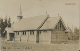
St. Alban's church
https://search.heritageburnaby.ca/link/museumdescription19780
- Repository
- Burnaby Village Museum
- Date
- 1920
- Collection/Fonds
- Esther Love Stanley fonds
- Description Level
- Item
- Physical Description
- 1 photograph : b&w postcard ; 8.5 x 13.5 cm
- Scope and Content
- Photograph of St. Albans the Martyr Anglican Church. This was probably the second Burnaby church (after St. John the Divine Anglican Church near Central Park), built c. 1909. Members of the Love family worshiped here and many got married in this church.
- Repository
- Burnaby Village Museum
- Collection/Fonds
- Esther Love Stanley fonds
- Description Level
- Item
- Physical Description
- 1 photograph : b&w postcard ; 8.5 x 13.5 cm
- Scope and Content
- Photograph of St. Albans the Martyr Anglican Church. This was probably the second Burnaby church (after St. John the Divine Anglican Church near Central Park), built c. 1909. Members of the Love family worshiped here and many got married in this church.
- Subjects
- Buildings - Religious - Churches
- Geographic Access
- 19th Avenue
- Street Address
- 7717 19th Avenue
- Accession Code
- BV022.32.202
- Access Restriction
- No restrictions
- Reproduction Restriction
- No known restrictions
- Date
- 1920
- Media Type
- Photograph
- Historic Neighbourhood
- Edmonds (Historic Neighbourhood)
- Planning Study Area
- Edmonds Area
- Scan Resolution
- 600
- Scan Date
- 2023-04-04
- Notes
- Title based on contents of photograph
- Photograph is part of Esther Love Stanley photograph album 1 (BV022.32.1)
Images
