Narrow Results By
Mortimer-Lamb House
https://search.heritageburnaby.ca/link/landmark494
- Repository
- Burnaby Heritage Planning
- Description
- The Mortimer-Lamb House is a one and one half-storey, Arts and Crafts-style residence with a steeply pitched, side-gabled roof. The original cottage form has been enlarged with a later addition on the west side of the house. Located next to the Burnaby Lake Regional Park Wildlife Rescue Care Centre…
- Associated Dates
- c.1922
- Formal Recognition
- Community Heritage Register
- Other Names
- Harold & Katherine Mortimer-Lamb Residence
- Street View URL
- Google Maps Street View
- Repository
- Burnaby Heritage Planning
- Other Names
- Harold & Katherine Mortimer-Lamb Residence
- Geographic Access
- Glencarin Drive
- Associated Dates
- c.1922
- Formal Recognition
- Community Heritage Register
- Enactment Type
- Council Resolution
- Enactment Date
- 26/05/2003
- Description
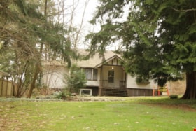
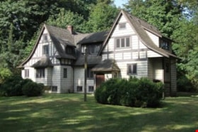
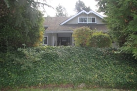
- The Mortimer-Lamb House is a one and one half-storey, Arts and Crafts-style residence with a steeply pitched, side-gabled roof. The original cottage form has been enlarged with a later addition on the west side of the house. Located next to the Burnaby Lake Regional Park Wildlife Rescue Care Centre, the house has picturesque views of Burnaby Lake.
- Heritage Value
- Built circa 1922, the Mortimer-Lamb House is valued for its association with first owners, Harold Mortimer-Lamb (1872-1970), and his wife, Katherine Mary Mortimer-Lamb (1873-1939). Born in Leatherhead, Surrey, England, Harold Mortimer-Lamb immigrated to Canada in 1889. Seven years later in Vancouver, he married Katherine Mary Lindsay, a native of Winnipeg. Mortimer-Lamb was a key figure in the B.C. mining industry, serving as Secretary of the Mining Association of B.C. between 1900 and 1945, and also as the Secretary of the Canadian Institute of Mining and Metallurgy. In addition to his professional life, Mortimer-Lamb was a pioneer art photographer and was among Canada's leading art critics, and this house served as a central gathering place for renowned Canadian artists of the day. Mortimer-Lamb’s daughter, Molly Lamb Bobak (born 1922), became a renowned watercolourist, and was the only woman ever hired as an official Canadian war artist. The Mortimer-Lamb House is a significant example of the work of noted architect, Samuel Maclure (1860-1929) and his partner, Ross Lort (1889-1969). Maclure, who was a close friend of the Mortimer-Lamb family, was British Columbia's leading residential architect, and was renowned for his high quality designs for prominent citizens in both Vancouver and Victoria. Maclure was a leading exponent of the Art and Crafts design movement in B.C., and established a sophisticated local variation of residential architecture. The Mortimer-Lamb House was designed at the time when Maclure was in partnership with Ross Lort. In 1907, Lort began working for Maclure's firm as a draftsman, and by 1920 was in charge of Maclure's Vancouver office. Lort's architectural career spanned some sixty-years, and he designed some of the province's most familiar houses, apartments, institutions and places of worship. The Mortimer-Lamb House is also a significant local example of the Arts and Crafts style, and incorporates elements such as board-and-batten siding on the ground floor, shingled gables and leaded casement windows. It is a testament to the domestic architecture built outside of established suburbs during the post-First World War era, typically modest in scale and representative of middle-class residential ideals.
- Defining Elements
- Key elements that define the heritage character of the Mortimer-Lamb House include its: - treed setting with views of Burnaby Lake - residential form, scale and massing as expressed by its one and one-half storey height, rectangular plan and steeply pitched side-gabled roof - wood-frame construction - Arts and Crafts elements such as board-and-batten siding on the ground floor, cedar shingles in the gables and open soffits - original straight-leaded casement windows in single and multiple-assembly - internal red-brick chimney with corbelled cap
- Historic Neighbourhood
- Burnaby Lake (Historic Neighbourhood)
- Planning Study Area
- Burnaby Lake Area
- Organization
- Mining Association of B.C.
- G.F. and J. Galt Limited
- Architect
- Samuel Maclure
- Ross Lort
- Function
- Primary Historic--Single Dwelling
- Primary Current--Single Dwelling
- Community
- Burnaby Lake
- Cadastral Identifier
- P.I.D.002-977-788
- Boundaries
- The Mortimer-Lamb House is comprised of a single residential lot located at 5180 Glencairn Drive, Burnaby.
- Area
- 5652.78
- Contributing Resource
- Building
- Ownership
- Private
- Documentation
- City of Burnaby Planning and Building Department, Heritage Site Files
- Street Address
- 5180 Glencarin Drive
- Street View URL
- Google Maps Street View
Images
E.W. Bateman House 'Elworth'
https://search.heritageburnaby.ca/link/landmark538
- Repository
- Burnaby Heritage Planning
- Description
- The E.W. Bateman House is a one-and-one-half storey wood-frame residence set within in a garden landscape. The house and its adjacent garage are the only historic buildings standing on their original site within the Burnaby Village Museum property.
- Associated Dates
- 1922
- Formal Recognition
- Heritage Designation, Community Heritage Register
- Other Names
- Edwin & Mary Bateman Residence
- Street View URL
- Google Maps Street View
- Repository
- Burnaby Heritage Planning
- Other Names
- Edwin & Mary Bateman Residence
- Geographic Access
- Deer Lake Avenue
- Associated Dates
- 1922
- Formal Recognition
- Heritage Designation, Community Heritage Register
- Enactment Type
- Bylaw No. 9807
- Enactment Date
- 23/11/1992
- Description
- The E.W. Bateman House is a one-and-one-half storey wood-frame residence set within in a garden landscape. The house and its adjacent garage are the only historic buildings standing on their original site within the Burnaby Village Museum property.
- Heritage Value
- The E.W. Bateman House was constructed in the Deer Lake Crescent subdivision, that was originally promoted in 1911 as an upper class suburban neighbourhood. It represents one of the first residential developments in the City of Burnaby that required buildings to be of a specific value, thus demonstrating the desire for exclusivity among the successful businessmen who chose to settle in the area. The house and grounds illustrate the reduced scale of upper-class residential construction at a time of modest returning prosperity that followed the end of the First World War, and the social, cultural, lifestyle and leisure sensibilities of the owners in the Deer Lake Crescent subdivision: such values as social aspiration, racial exclusivity, demonstration of architectural taste, and importance of a landscaped garden. The heritage value of the E.W. Bateman House is its comprehensive representation of an upper middle-class suburban residence of the early 1920s. It was built for retired CPR executive Edwin Wettenhall Bateman (1859-1957) and his wife, Mary (Dale) Bateman (1865-1935), by contractor William Dodson in 1922. The Bateman House was designed by English-born and trained architect Enoch Evans (1862-1939) of E. Evans and Son, and is an important surviving residential design by Evans, and a typical example of the eclectic Period Revival influences that were common to domestic architecture in the post-First World War era. The symmetry of the imposing front verandah, supported by exaggerated Ionic columns, gives the relatively-modest house an image of grandeur and formality. Named after Edwin Bateman’s birthplace in Cheshire, England, ‘Elworth’ also symbolizes allegiance to England and the patriotic tenor of the time. The heritage value for this house also lies in its interpretive value within the Burnaby Village Museum. The site is an important cultural feature for the interpretation of Burnaby’s heritage to the public. The E.W. Bateman House was purchased by Burnaby in 1970 and became the focal point for the development of the Museum. Both the interior and exterior of the house have been restored and interpreted to the date of original construction, including recreated room interiors and period furnishings.
- Defining Elements
- The elements that define the heritage character of the E.W. Bateman House include its: - rectangular form and massing with central entry on long side - side gable roof with front shed dormer with cedar shingle cladding - symmetry of front facade - full open front verandah inset under the roofline, supported with Ionic columns - cedar shingle siding - multi-paned double-hung wooden-sash windows, mixture of 6-over-1 and 8-over-1 - symmetrical disposition of fenestration, with double-assembly units on the ground floor - exterior shutters - two flanking brick chimneys on the side elevations - interior room layouts and original interior features such as quality millwork and original hardware - original garage at the rear of the house
- Locality
- Deer Lake Park
- Historic Neighbourhood
- Burnaby Lake (Historic Neighbourhood)
- Planning Study Area
- Morley-Buckingham Area
- Organization
- Burnaby Village Museum
- Architect
- Enoch Evans
- E. Evans and Son
- Builder
- William Dodson
- Function
- Primary Current--Museum
- Primary Historic--Single Dwelling
- Community
- Burnaby
- Cadastral Identifier
- P.I.D. No. 011-030-356 Legal Description: Parcel 1, District Lot 79 and District Lot 85, Group 1, New Westminster District, Reference Plan 77594
- Boundaries
- Burnaby Village Museum is comprised of a single municipally-owned property located at 6501 Deer Lake Avenue, Burnaby.
- Area
- 38,488.63
- Contributing Resource
- Building
- Landscape Feature
- Structure
- Ownership
- Public (local)
- Documentation
- Heritage Site Files: PC77000 20. City of Burnaby Planning and Building Department, 4949 Canada Way, Burnaby, B.C., V5G 1M2
- Subjects
- Buildings - Residential
- Buildings - Residential - Houses
- Buildings - Heritage
- Buildings - Civic - Museums
- Street Address
- 6501 Deer Lake Avenue
- Street View URL
- Google Maps Street View
Images
Lochdale Community Hall
https://search.heritageburnaby.ca/link/landmark549
- Repository
- Burnaby Heritage Planning
- Description
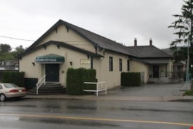
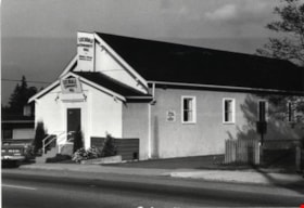
- The Lochdale Community Hall is a one-storey wood-frame building located on Sperling Avenue, near its intersection with Hastings Street, in the centre of the Lochdale district in North Burnaby. Built in stages, its current configuration has an L-shaped plan, with three different roof structures.
- Associated Dates
- 1925
- Formal Recognition
- Heritage Designation, Community Heritage Register
- Street View URL
- Google Maps Street View
- Repository
- Burnaby Heritage Planning
- Geographic Access
- Sperling Avenue
- Associated Dates
- 1925
- Formal Recognition
- Heritage Designation, Community Heritage Register
- Enactment Type
- Bylaw No. 9807
- Enactment Date
- 23/11/1992
- Description
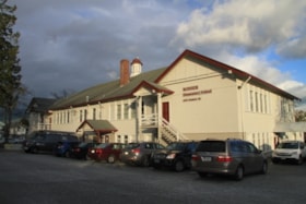
- The Lochdale Community Hall is a one-storey wood-frame building located on Sperling Avenue, near its intersection with Hastings Street, in the centre of the Lochdale district in North Burnaby. Built in stages, its current configuration has an L-shaped plan, with three different roof structures.
- Heritage Value
- The heritage value of the Lochdale Community Hall is as Burnaby’s last remaining early community hall building. It was constructed with volunteer labour and donated materials in 1925 through the efforts of the Lochdale Social Club. The Hall is a valuable reminder of the way in which early communities banded together for mutual support at a time when transportation was more difficult and local communities were more isolated than today. This residents’ association has used this building to support the community through public political meetings, theatre, dinners and dances, creating strong community ties in North Burnaby. The Hall was also used briefly for the services of St. Margaret of Scotland Anglican parish until their church was completed in 1929, demonstrating a spirit of community cooperation at a time when local institutions were being established in the area.
- Defining Elements
- Key elements that define the heritage character of the Lochdale Community Hall include its: - central location in the Lochdale community - modest vernacular architecture and massing - stepped-pitch gable roof of the main hall - shallow-pitched gable roof of the entrance porch - Craftsman style eave brackets - central front entry - interior features such as the main open hall with an elevated stage
- Locality
- Lochdale
- Historic Neighbourhood
- Lochdale (Historic Neighbourhood)
- Planning Study Area
- Lochdale Area
- Organization
- Lochdale Social Club
- Function
- Primary Current--Recreation Centre
- Primary Historic--Recreation Centre
- Community
- Burnaby
- Cadastral Identifier
- P.I.D. No. 012-091-901 Legal Description: Lot 11 Except: East five feet , Block 6, District Lot 206, Group 1, New Westminster District, Plan 1323
- Boundaries
- The Lochdale Community Hall is comprised of a single municipally-owned property located at 490 Sperling Avenue, Burnaby.
- Area
- 1,260.00
- Contributing Resource
- Building
- Ownership
- Public (local)
- Other Collection
- St. Margaret of Scotland Parish Fonds, Anglican Diocese of New Westminster Archives.
- Documentation
- Heritage Site Files: PC77000 20. City of Burnaby Planning and Building Department, 4949 Canada Way, Burnaby, B.C., V5G 1M2
- Street Address
- 490 Sperling Avenue
- Street View URL
- Google Maps Street View
Images
Louis & Annie Hill Residence
https://search.heritageburnaby.ca/link/landmark504
- Repository
- Burnaby Heritage Planning
- Description
- The Louis and Annie Hill Residence is a modest one-storey, wood-frame, side-gabled Arts and Crafts bungalow with two projecting front gables, that was originally part of the Deer Lake Crescent Subdivision. The lot is heavily treed, and sits near the east end of Deer Lake.
- Associated Dates
- 1925
- Street View URL
- Google Maps Street View
- Repository
- Burnaby Heritage Planning
- Geographic Access
- Deer Lake Avenue
- Associated Dates
- 1925
- Description
- The Louis and Annie Hill Residence is a modest one-storey, wood-frame, side-gabled Arts and Crafts bungalow with two projecting front gables, that was originally part of the Deer Lake Crescent Subdivision. The lot is heavily treed, and sits near the east end of Deer Lake.
- Heritage Value
- The heritage value of the Louis and Annie Hill Residence lies in its association with prominent Burnaby pioneers, Louis Hill (1860-1931) and his wife, Annie Sara Hill (née Kenrick, 1864-1957). Originally from London, England, Louis Hill immigrated to Burnaby circa 1887, and established a small fruit farm on this site in 1891. Hill was elected to the first municipal council in 1892, when Burnaby was incorporated, and was later responsible for the subdivision of Buckingham Estate in the Deer Lake neighbourhood. The Louis and Annie Hill Residence, built as a retirement home in 1925, is further valued as a representation of the continued suburban development of the Deer Lake Crescent Subdivision, that was originally promoted in 1911 as an upper class suburban neighbourhood. Its modest nature illustrates the reduced scale of residential construction during the austere times that followed the end of the First World War. The style of the house demonstrates the late persistence of the Arts and Crafts movement, which remained a strong influence on domestic architecture. In 2006, the Louis and Annie Hill Residence was purchased by the City of Burnaby, and today it is part of the Deer Lake Park Heritage Precinct, Burnaby's most significant collection of historic sites.
- Defining Elements
- Key elements that define the heritage character of the Louis and Annie Hill Residence include its: - location within the Deer Lake Park Heritage Precinct - residential form, scale and massing as expressed by its one-storey height plus crawlspace, side-gabled-roof, front projecting gables, square projecting front bay and open front porch - wood-frame construction with original wood siding intact under a later coat of stucco - modest Arts and Crafts details such as diamond-point triangular eave brackets - windows, including double-hung, 1-over-1 wooden sash windows with horns - associated landscape features, including mature cedars lining the driveway
- Historic Neighbourhood
- Burnaby Lake (Historic Neighbourhood)
- Planning Study Area
- Morley-Buckingham Area
- Function
- Primary Historic--Single Dwelling
- Primary Current--Single Dwelling
- Community
- Deer Lake
- Cadastral Identifier
- P.I.D.012-446-963
- Boundaries
- The Louis and Annie Hill Residence is comprised of a single residential lot located at 6570 Deer Lake Avenue, Burnaby.
- Area
- 1521.75
- Contributing Resource
- Building
- Ownership
- Public (local)
- Documentation
- City of Burnaby Planning and Building Department, Heritage Site Files
- Street Address
- 6570 Deer Lake Avenue
- Street View URL
- Google Maps Street View
Images
Seaforth Schoolhouse
https://search.heritageburnaby.ca/link/landmark541
- Repository
- Burnaby Heritage Planning
- Description
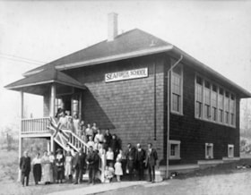
- The Seaforth Schoolhouse is a one-storey wood-frame rectangular plan building with a projecting entry porch, located in the Burnaby Village Museum.
- Associated Dates
- 1922
- Formal Recognition
- Heritage Designation, Community Heritage Register
- Repository
- Burnaby Heritage Planning
- Geographic Access
- Deer Lake Avenue
- Associated Dates
- 1922
- Formal Recognition
- Heritage Designation, Community Heritage Register
- Enactment Type
- Bylaw No. 8148
- Enactment Date
- 03/01/1984
- Description
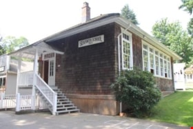
- The Seaforth Schoolhouse is a one-storey wood-frame rectangular plan building with a projecting entry porch, located in the Burnaby Village Museum.
- Heritage Value
- The heritage value of the Seaforth Schoolhouse lies in its representation of a one-room school once located in one of the city’s rural districts. The school was constructed due to the demand of increasing population after the First World War, in what was then known as the Lozells District, so isolated at the time that parents were concerned about the danger to their children from wild bears and cougars that roamed the area. The school was named after its sponsor, the Seaforth Chapter of the Imperial Order of Daughters of the Empire. Bowman and Cullerne, the architects for the Burnaby School Board, designed the one room schoolhouse. It was constructed by local contractor, Alphonse J. Toebaert, following the standards of British Columbia public school architecture, which specified the plan and orientation of the building. It indicates the values and the design control of school boards of the time, and the central role of the provincial government in setting educational standards. The heritage value of this school also lies in its interpretive value within the Burnaby Village Museum. The site is an important cultural feature for the interpretation of Burnaby’s heritage to the public, illustrating the changes in the local school system over time. The school was moved to Burnaby Village Museum in 1983, and was opened to the public after extensive restoration in 1987. Both the interior and exterior have been restored and interpreted to the date of original construction. The North Vancouver School Board donated most of the early desks, and the remainder of the interior artifacts are from the museum’s own collection.
- Defining Elements
- Key elements that define the heritage character of the Seaforth Schoolhouse include its: - rectangular plan - hipped roof with cedar shingle cladding - hipped-roof entry porch - typical school fenestration of the era, with a bank of double-hung 6-over-6 wooden-sash windows on one facade - cedar shingle cladding - original and authentic interior elements such as interior mouldings, blackboards and desks
- Locality
- Deer Lake Park
- Historic Neighbourhood
- Burnaby Lake (Historic Neighbourhood)
- Planning Study Area
- Morley-Buckingham Area
- Organization
- Seaforth Chapter of the Imperial Order of Daughters of the Empire
- Burnaby School Board
- Burnaby Village Museum
- Architect
- Bowman and Cullerne
- Builder
- Alphonse J. Toebaert
- Function
- Primary Historic--One-Room School
- Primary Current--Museum
- Community
- Burnaby
- Cadastral Identifier
- P.I.D. No. 011-030-356 Legal Description: Parcel 1, District Lot 79 and District Lot 85, Group 1, New Westminster District, Reference Plan 77594
- Boundaries
- Burnaby Village Museum is comprised of a single municipally-owned property located at 6501 Deer Lake Avenue, Burnaby.
- Area
- 38,488.63
- Contributing Resource
- Building
- Landscape Feature
- Structure
- Ownership
- Public (local)
- Documentation
- Heritage Site Files: PC77000 20. City of Burnaby Planning and Building Department, 4949 Canada Way, Burnaby, B.C., V5G 1M2
- Street Address
- 6501 Deer Lake Avenue
Images
Stanley & Isabel Picken House 'Aintree'
https://search.heritageburnaby.ca/link/landmark519
- Repository
- Burnaby Heritage Planning
- Description
- Nestled within a stand of deciduous trees, the Stanley and Isabel Picken House 'Aintree' is a two and one-half storey plus basement shingled and half-timbered Arts and Crafts influenced residence, set on its original 0.6 hectare site adjacent to Brunette Creek in the Burnaby Lake Regional Nature Pa…
- Associated Dates
- 1929
- Formal Recognition
- Heritage Designation, Community Heritage Register
- Street View URL
- Google Maps Street View
- Repository
- Burnaby Heritage Planning
- Geographic Access
- Cariboo Road
- Associated Dates
- 1929
- Formal Recognition
- Heritage Designation, Community Heritage Register
- Enactment Type
- Bylaw No. 11756
- Enactment Date
- 09/08//2004
- Description
- Nestled within a stand of deciduous trees, the Stanley and Isabel Picken House 'Aintree' is a two and one-half storey plus basement shingled and half-timbered Arts and Crafts influenced residence, set on its original 0.6 hectare site adjacent to Brunette Creek in the Burnaby Lake Regional Nature Park.
- Heritage Value
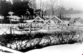
- 'Aintree' is an example of the type of private country estate residences built in Burnaby outside of the established suburbs during the 1920s, and is representative of middle-class residential life during this time. Stanley Boyd Picken (1890-1950) and Isabel Grace Frederique Picken (1893-1971) purchased this property in 1927 to establish the Aintree Dog Kennels, which was the first in the province to breed Irish Setters. This country residence was completed in 1929. Stanley Picken worked at a variety of other jobs including his position as keeper of the Brunette River Caribou Dam. Considered a fine example of romantic architecture, 'Aintree' stands in harmony with its woodland setting. The north wing was added in a compatible style in 1932 using former bridge support beams from the old Caribou Road Bridge for foundation support. 'Aintree' retains most of its original exterior elements including its picturesque shingled siding and half-timbering, demonstrating the late influence of an Arts and Crafts sensibility considered compatible with a country lifestyle.
- Defining Elements
- Key elements that define the heritage character of 'Aintree' include its: - woodland setting adjacent to Brunette Creek in the Burnaby Lake Regional Nature Park, with a deep setback from Cariboo Road - residential form, scale and massing as exemplified by its asymmetrical two and one-half storey plus basement height and irregular U-shaped plan - romantic Arts and Crafts influence as expressed in elements such as half-timbering on the upper storeys and hand-split cedar shake wall cladding - steeply pitched cross-gabled roofs with dormers connected by a lower central gabled roof, and 'cat slide' extension over side entry - regular fenestration, including wooden-sash casement windows with diamond leaded glass - red brick internal chimney with corbelled cap - associated landscape features, such as a curving driveway leading to the house, an early garage, grassed yard and a backdrop of mature deciduous trees
- Historic Neighbourhood
- Burquitlam (Historic Neighbourhood)
- Planning Study Area
- Burnaby Lake Area
- Function
- Primary Historic--Single Dwelling
- Community
- Burnaby
- Cadastral Identifier
- 010-867-147
- Boundaries
- 'Aintree' is comprised of a single residential lot located at 6825 Cariboo Road, Burnaby.
- Area
- 5436.75
- Contributing Resource
- Building
- Ownership
- Private
- Names
- Picken, Stanley
- Street Address
- 6825 Cariboo Road
- Street View URL
- Google Maps Street View
Images
Kitchener Elementary School
https://search.heritageburnaby.ca/link/landmark614
- Repository
- Burnaby Heritage Planning
- Description
- School building.
- Associated Dates
- 1925
- Street View URL
- Google Maps Street View
- Repository
- Burnaby Heritage Planning
- Geographic Access
- Gilmore Avenue
- Associated Dates
- 1925
- Description
- School building.
- Heritage Value
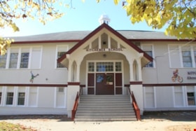
- This landmark school was designed by the architectural firm of Bowman & Cullerne, specialists in the design of educational facilities. After Harold Cullerne (1890-1976) returned from service during the First World War, he joined J.H. Bowman (1864-1943) in a partnership that lasted from 1919 to 1934. The firm’s projects include the Seaforth School (1922, now relocated to Burnaby Village Museum), Burnaby North High School (1923), and the Nelson Avenue School (1927). This was originally designed as a two-storey, four-room building in 1925, with two-storey four-room wings added two years later. The building has been altered with the addition of stucco cladding over the original siding and replacement windows, but has retained its original form and massing, as well as its domed roof ventilator.
- Locality
- Vancouver Heights
- Historic Neighbourhood
- Vancouver Heights (Historic Neighbourhood)
- Planning Study Area
- Willingdon Heights Area
- Architect
- Bowman & Cullerne
- Area
- 20478.11
- Contributing Resource
- Building
- Street Address
- 1351 Gilmore Avenue
- Street View URL
- Google Maps Street View
Images
Lake City Neighbourhood
https://search.heritageburnaby.ca/link/landmark702
- Repository
- Burnaby Heritage Planning
- Associated Dates
- 1925-1954
- Heritage Value
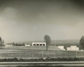
- When the Lake City Industrial Park first opened in the 1950's, it was a fairly isolated industrial enclave with convenient access to rail and road transportation routes. The sense of entrepreneurial flare and success that was anticipated for the area is evident in the naming of local streets which include "Production", "Enterprise" and "Venture". The anticipated potential of the area was also demonstrated by the inclusion of many significant development amenities of the time, such as paved streets, site landscaping, rail service, natural gas service, and architectural controls.
- Planning Study Area
- Lake City Area
Images
Ocean View Burial Park - Mausoleum
https://search.heritageburnaby.ca/link/landmark630
- Repository
- Burnaby Heritage Planning
- Geographic Access
- Imperial Street
- Associated Dates
- 1928
- Description
- Cemetery site.
- Heritage Value
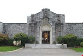
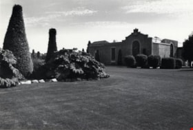
- In 1928, the design for the Ocean View Abbey was provided by San Francisco architect Wallace H. Hubbert, who specialized in the design of mausoleums. This was the first large-scale mausoleum and columbarium constructed in British Columbia. Although planned to be a much larger structure initially, only one wing was completed in 1931 before the Great Depression halted further additions. Hubbert was born in San Francisco in 1891 and attended the San Francisco Architectural Club. From 1914-15, he worked for famed architect Bernard Maybeck, and during the Depression years he temporarily closed his solo practice and worked for Miller & Pflueger from 1935-1939. He died in San Francisco in 1948. Hubbert was responsible for the designs of the Sunset Mausoleums in Berkeley and Eureka, Evergreen Mausoleum in Oakland and others in Merced and Santa Monica.
- Locality
- Alta Vista
- Historic Neighbourhood
- Alta Vista (Historic Neighbourhood)
- Planning Study Area
- Suncrest Area
- Architect
- Wallace H. Hubbert
- Area
- 359280.00
- Contributing Resource
- Building
- Ownership
- Private
- Street Address
- 4000 Imperial Street
Images
Rosser Elementary School
https://search.heritageburnaby.ca/link/landmark636
- Repository
- Burnaby Heritage Planning
- Description
- School building.
- Associated Dates
- 1923
- Other Names
- NORTH BURNABY HIGH SCHOOL
- Street View URL
- Google Maps Street View
- Repository
- Burnaby Heritage Planning
- Other Names
- NORTH BURNABY HIGH SCHOOL
- Geographic Access
- Pandora Street
- Associated Dates
- 1923
- Description
- School building.
- Heritage Value
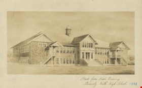
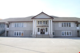
- Originally built as North Burnaby High School, this eight-room school became Rosser Avenue School in 1945. It has been altered with replacement windows, the application of stucco over the original siding and an addition, but has retained its historical form, including a hipped roof with half-timbered gables and a domed roof ventilator. The Rosser Elementary School was designed by the architectural firm of Bowman & Cullerne, who specialized in school design. The firm’s projects include Seaforth School (1922, now relocated to Burnaby Village Museum), Windsor Street School (1923), and Nelson Avenue School (1927).
- Locality
- Vancouver Heights
- Historic Neighbourhood
- Vancouver Heights (Historic Neighbourhood)
- Planning Study Area
- Burnaby Heights Area
- Architect
- Bowman and Cullerne
- Area
- 10579.94
- Contributing Resource
- Building
- Street Address
- 4375 Pandora Street
- Street View URL
- Google Maps Street View
Images
William & Annie Mawhinney Residence
https://search.heritageburnaby.ca/link/landmark654
- Repository
- Burnaby Heritage Planning
- Description
- Residential building.
- Associated Dates
- 1923
- Street View URL
- Google Maps Street View
- Repository
- Burnaby Heritage Planning
- Geographic Access
- Burris Street
- Associated Dates
- 1923
- Description
- Residential building.
- Heritage Value
- This bungalow was built by local farmer William Alexander Mawhinney (1870-1953) and Annie J. Mawhinney (1871-1956). This was one of several houses built in the immediate vicinity by members of the Mawhinney family between 1909 and 1930. William Mawhinney first came to Burnaby to help his brother Isaiah establish his fruit farm. In about 1930, William and Annie Mawhinney built a new house at 6011 Buckingham Avenue. This home is architecturally notable for its unusual front-gabled dormer, which is divided into parallel ridges at its peak. Though the original exterior wall siding has been covered by a later coat of stucco, it otherwise remains in largely original condition including double-hung windows with multi-paned upper sashes, front door with full-length sidelights and a decorative built-in window box.
- Locality
- Burnaby Lake
- Historic Neighbourhood
- Burnaby Lake (Historic Neighbourhood)
- Planning Study Area
- Morley-Buckingham Area
- Area
- 891.70
- Contributing Resource
- Building
- Ownership
- Private
- Street Address
- 7616 Burris Street
- Street View URL
- Google Maps Street View
Images
Windsor Street School
https://search.heritageburnaby.ca/link/landmark659
- Repository
- Burnaby Heritage Planning
- Description
- School building.
- Associated Dates
- 1924
- Street View URL
- Google Maps Street View
- Repository
- Burnaby Heritage Planning
- Geographic Access
- Imperial Street
- Associated Dates
- 1924
- Description
- School building.
- Heritage Value
- This school was built to replace Kingsway East School, which became part of Burnaby South High School. Architects Bowman & Cullerne designed the school in 1924; additions were made in 1927. The school features a distinctive double-height gabled entrance, a broad hipped roof and an octagonal rooftop ventilator. The Windsor Street School was designed by the architectural firm of Bowman & Cullerne, who specialized in school design. The firm’s projects include Seaforth School (1922, now relocated to Burnaby Village Museum), Burnaby North High School (1923), and Nelson Avenue School (1927).
- Locality
- Edmonds
- Historic Neighbourhood
- Edmonds (Historic Neighbourhood)
- Planning Study Area
- Windsor Area
- Architect
- Bowman & Cullerne
- Area
- 3716.12
- Contributing Resource
- Building
- Street Address
- 6166 Imperial Street
- Street View URL
- Google Maps Street View


