Narrow Results By
Decade
- 2020s 6
- 2010s 6
- 2000s 72
- 1990s 84
- 1980s 33
- 1970s 53
- 1960s 56
- 1950s
- 1940s 55
- 1930s 94
- 1920s 210
- 1910s 178
- 1900s 108
- 1890s 55
- 1880s
- 1870s 4
- 1860s 8
- 1850s 2
- 1810s 1
- 1800s 1
- 1790s 1
- 1780s 1
- 1770s
- 1760s 1
- 1750s 1
- 1740s 1
- 1730s 1
- 1720s 1
- 1710s 1
- 1700s 1
- 1690s 1
- 1680s 1
- 1670s 1
- 1660s 1
- 1650s 1
- 1640s 1
- 1630s 1
- 1620s 1
- 1610s 1
- 1600s 1
- 1590s 1
- 1580s 1
- 1570s 1
- 1560s 1
- 1550s 1
- 1540s 1
- 1530s 1
- 1520s 1
- 1510s 1
- 1500s 1
- 1490s 1
- 1480s 1
Subject
- Advertising Medium 1
- Advertising Medium - Signs and Signboards 1
- Agriculture - Farms 4
- Agriculture - Fruit and Berries 1
- Animals - Horses 1
- Building - Agricultural 2
- Buildings - Commercial 2
- Buildings - Commercial - Department Stores 19
- Buildings - Commercial - Hotels and Motels 2
- Buildings - Commercial - Restaurants 2
- Buildings - Industrial - Mills 4
- Buildings - Religious - Churches 1
Person / Organization
- Baehr, G. A. 1
- British Columbia Electric Railway Company 9
- Burnaby Arts Centre 1
- Burnaby Historical Society 2
- Burnaby South High School 2
- Burnaby Writers' Club 1
- Burton, Charles Luther 3
- Burton, Edgar G. 3
- Burton, John 5
- Byrne, Ultan Patrick "Pat" 1
- Chan, Puy Yuen 1
- The Chinese Benevolent Association 1

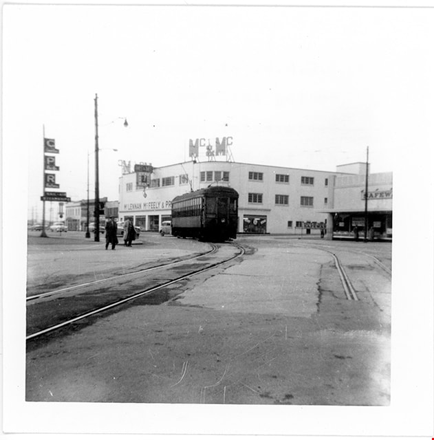
B.C. Electric Railway no. 1232 coming into New Westminster Depot
https://search.heritageburnaby.ca/link/museumdescription2895
- Repository
- Burnaby Village Museum
- Date
- 12 Feb. 1956
- Collection/Fonds
- Burnaby Village Museum Photograph collection
- Description Level
- Item
- Physical Description
- 1 photograph : b&w ; 9 x 9 cm
- Scope and Content
- Photograph of B.C. Electric Railway tram no.1232 coming into New Westminster Depot off the Marpole Line. The Mc & Mc store is visible in the background.
- Repository
- Burnaby Village Museum
- Collection/Fonds
- Burnaby Village Museum Photograph collection
- Description Level
- Item
- Physical Description
- 1 photograph : b&w ; 9 x 9 cm
- Scope and Content
- Photograph of B.C. Electric Railway tram no.1232 coming into New Westminster Depot off the Marpole Line. The Mc & Mc store is visible in the background.
- Subjects
- Transportation - Electric Railroads
- Accession Code
- BV012.36.3
- Access Restriction
- No restrictions
- Reproduction Restriction
- No known restrictions
- Date
- 12 Feb. 1956
- Media Type
- Photograph
- Scan Resolution
- 600
- Scan Date
- 2022-07-26
- Notes
- Title based on contents of photograph
- Typewritten text on verso of photograph reads: "BCER #1232 coming into New Westminster Depot / off the Marpole / Line. / Sunday, Feburary 12, 1956"
Images
![B.C. Electric Railway tram no. 1315 tram leaving New Westminster
, [1953] thumbnail](/media/hpo/_Data/_BVM_Images/2012/2012_0036_0005_001.jpg?width=280)
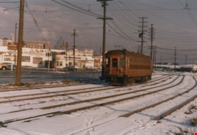
B.C. Electric Railway tram no. 1315 tram leaving New Westminster
https://search.heritageburnaby.ca/link/museumdescription2897
- Repository
- Burnaby Village Museum
- Date
- [1953]
- Collection/Fonds
- Burnaby Village Museum Photograph collection
- Description Level
- Item
- Physical Description
- 1 photograph : b&w ; 9 x 13 cm
- Scope and Content
- Photograph of B.C. Electric Railway tram no. 1315 tram leaving New Westminster station. The photographer is facing east and standing at the Columbia St. and Eighth Ave. inersection. There are many automobiles on Columbia Street..
- Repository
- Burnaby Village Museum
- Collection/Fonds
- Burnaby Village Museum Photograph collection
- Description Level
- Item
- Physical Description
- 1 photograph : b&w ; 9 x 13 cm
- Scope and Content
- Photograph of B.C. Electric Railway tram no. 1315 tram leaving New Westminster station. The photographer is facing east and standing at the Columbia St. and Eighth Ave. inersection. There are many automobiles on Columbia Street..
- Subjects
- Transportation - Electric Railroads
- Accession Code
- BV012.36.5
- Access Restriction
- No restrictions
- Reproduction Restriction
- No known restrictions
- Date
- [1953]
- Media Type
- Photograph
- Scan Resolution
- 600
- Scan Date
- 2022-07-26
- Notes
- Title based on contents of photograph
- Typewritten text on verso of photograph reads: "BCER #1315 leaves New Westminster / terminal west bound to Vancouver, / spring of 1953"
- Date stamp on recto of photograph reads: "Nov_64"
Images
![B.C. Electric Railway tram no. 1315 tram leaving New Westminster
, [1953] thumbnail](/media/hpo/_Data/_BVM_Images/2012/2012_0036_0005_001.jpg)
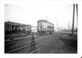
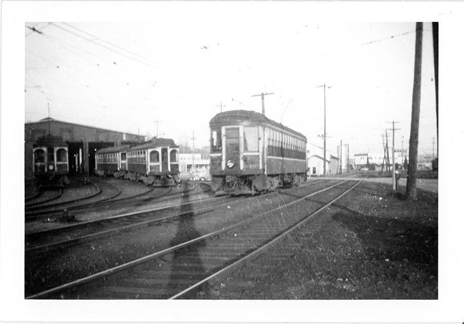
B.C. Electric Railway tram no. 1317 tram passing New Westminster barns
https://search.heritageburnaby.ca/link/museumdescription2898
- Repository
- Burnaby Village Museum
- Date
- 1952
- Collection/Fonds
- Burnaby Village Museum Photograph collection
- Description Level
- Item
- Physical Description
- 1 photograph : b&w ; 9 x 13 cm
- Scope and Content
- Photograph of B.C. Electric Railway tram no. 1317 tram on the main line passing New Westminster barns and heading westbound to Vancouver. Other trams are visible in the background.
- Repository
- Burnaby Village Museum
- Collection/Fonds
- Burnaby Village Museum Photograph collection
- Description Level
- Item
- Physical Description
- 1 photograph : b&w ; 9 x 13 cm
- Scope and Content
- Photograph of B.C. Electric Railway tram no. 1317 tram on the main line passing New Westminster barns and heading westbound to Vancouver. Other trams are visible in the background.
- Subjects
- Transportation - Electric Railroads
- Accession Code
- BV012.36.6
- Access Restriction
- No restrictions
- Reproduction Restriction
- No known restrictions
- Date
- 1952
- Media Type
- Photograph
- Scan Resolution
- 600
- Scan Date
- 2022-07-26
- Notes
- Title based on contents of photograph
- Typewritten text on verso of photograph reads: "BCER #1317 passing New Westminster / barns westbound to Vancouver in 1952"
Images
![House at 315 5th Street, New Westminster, [between 1940 and 1959] thumbnail](/media/hpo/_Data/_Archives_Images/_Unrestricted/477/477-042.jpg?width=280)
House at 315 5th Street, New Westminster
https://search.heritageburnaby.ca/link/archivedescription38723
- Repository
- City of Burnaby Archives
- Date
- [between 1940 and 1959]
- Collection/Fonds
- Peers Family and Hill Family fonds
- Description Level
- Item
- Physical Description
- 1 photograph : sepia ; 7 x 11.5 cm
- Scope and Content
- Photograph of a house on 5th Street in New Westminster.
- Repository
- City of Burnaby Archives
- Date
- [between 1940 and 1959]
- Collection/Fonds
- Peers Family and Hill Family fonds
- Physical Description
- 1 photograph : sepia ; 7 x 11.5 cm
- Description Level
- Item
- Record No.
- 477-042
- Access Restriction
- No restrictions
- Reproduction Restriction
- No known restrictions
- Accession Number
- 2007-12
- Scope and Content
- Photograph of a house on 5th Street in New Westminster.
- Subjects
- Buildings - Residential - Houses
- Media Type
- Photograph
- Notes
- Title based on contents of photograph
Images
![House at 315 5th Street, New Westminster, [between 1940 and 1959] thumbnail](/media/hpo/_Data/_Archives_Images/_Unrestricted/477/477-042.jpg)
![Students at the Chinese school in New Westminster, [195-] thumbnail](/media/hpo/_Data/_BVM_Images/2020//2020_0038_0008_001.jpg?width=280)
Students at the Chinese school in New Westminster
https://search.heritageburnaby.ca/link/museumdescription14785
- Repository
- Burnaby Village Museum
- Date
- [195-]
- Collection/Fonds
- Julie Lee and Cecil Lee family fonds
- Description Level
- Item
- Physical Description
- 1 photograph (tiff) : b&w ; 600 dpi
- Scope and Content
- Photograph of a group of Chinese Canadian students standing on the stairs of the Chinese School in New Westminster. Frank and Emma Wong (members of the Quinn Wong family) are identified standing in the bottom left corner of the photograph and elder sister, Jessie Wong is identified standing in the …
- Repository
- Burnaby Village Museum
- Collection/Fonds
- Julie Lee and Cecil Lee family fonds
- Description Level
- Item
- Physical Description
- 1 photograph (tiff) : b&w ; 600 dpi
- Scope and Content
- Photograph of a group of Chinese Canadian students standing on the stairs of the Chinese School in New Westminster. Frank and Emma Wong (members of the Quinn Wong family) are identified standing in the bottom left corner of the photograph and elder sister, Jessie Wong is identified standing in the middle of the photograph. Members of the Kong family of Fraser Mills also appear in the photograph including Alice, Dorothy and Lea Kong along with members of the New Westminster Quan family. The front porch is decorated with bunting and includes a sign that reads "The Chinese Benevolent Association" along with a British flag and a flag of the Republic of China.
- Subjects
- Persons - Chinese Canadians
- Organizations - Societies and Clubs
- Persons - Students
- Buildings - Schools
- Names
- Wong, Quinn
- The Chinese Benevolent Association
- Kong, Alice
- Kong, Dorothy
- Kong, Lea
- Wong, Frank
- Wong, Emma
- Wong, Jessie
- Geographic Access
- New Westminster
- Accession Code
- BV020.38.8
- Access Restriction
- No restrictions
- Reproduction Restriction
- May be restricted by third party rights
- Date
- [195-]
- Media Type
- Photograph
- Scan Resolution
- 600
- Scan Date
- 26-Nov-2019
- Scale
- 100
- Notes
- Title based on contents of photograph
Images
![Students at the Chinese school in New Westminster, [195-] thumbnail](/media/hpo/_Data/_BVM_Images/2020//2020_0038_0008_001.jpg)
![Subdivision plans in New Westminster District Group 1 – Burnaby
, [1882-1910] thumbnail](/media/hpo/_Data/_BVM_Cartographic_Material/1977/1977_0093_0013a_001.jpg?width=280)
Subdivision plans in New Westminster District Group 1 – Burnaby
https://search.heritageburnaby.ca/link/museumdescription6982
- Repository
- Burnaby Village Museum
- Date
- [1882-1910]
- Collection/Fonds
- Burnaby Village Museum Map collection
- Description Level
- File
- Physical Description
- 4 plans : blueprint on paper mounted on 2 sides of cardboard 76 x 102 cm
- Scope and Content
- Item consists of a large board of two New Westminster District Gp 1 - subdivision plans mounted on one side and two New Westminster District Gp 1 - subdivision plans mounted on the other side. Side A: 1. Blueprint "Plan / of the / Subdivision / of / Lot 98 / G.1, N.W.D. / Scale 4 chs = 1 in. / …
- Repository
- Burnaby Village Museum
- Collection/Fonds
- Burnaby Village Museum Map collection
- Description Level
- File
- Physical Description
- 4 plans : blueprint on paper mounted on 2 sides of cardboard 76 x 102 cm
- Material Details
- Scales [between 1:1584 and 1:3168]
- Index number on edge of board reads: "13"
- Scope and Content
- Item consists of a large board of two New Westminster District Gp 1 - subdivision plans mounted on one side and two New Westminster District Gp 1 - subdivision plans mounted on the other side. Side A: 1. Blueprint "Plan / of the / Subdivision / of / Lot 98 / G.1, N.W.D. / Scale 4 chs = 1 in. / Map No 573" (Geographic location: Burnaby) 2. Blueprint "Plan / of Subdivision of / Lot 157 / Gr.1, New. West. Dist. / Scale 3 chs = 1 in. / Map No. 612". (Geographic location: Burnaby) Side B: 1. Blueprint "Plan / of Subdivision / of a Portion of / Lot 90 / Group One / New Westminster Dist. / Scale 2 chs = 1 in. / Map No. 555". Plan is signed by "Jno Strathern [sic]_P.L.S."n (Geographic location: Burnaby) 2. Blueprint "Subdivision of Lot 31, Group 1. / New Westminster District / As Amended by Order of Court / 1st Sept. 1882 and Numbered 847 / Scale 4 chs = 1in. / Map No 80" (Geographic location: Burnaby)
- Creator
- Stathern, John
- Accession Code
- HV977.93.13
- Access Restriction
- No restrictions
- Reproduction Restriction
- No known restrictions
- Date
- [1882-1910]
- Media Type
- Cartographic Material
- Historic Neighbourhood
- Alta Vista (Historic Neighbourhood)
- Planning Study Area
- Richmond Park Area
- Lakeview-Mayfield Area
- Scan Resolution
- 300
- Scale
- 72
- Notes
- Title based on contents of file
- Scale is measured in chains. (One chain equals 792 inches)
- The term "Lot" can also refer to a "District Lot”
Images
![Subdivision plans in New Westminster District Group 1 – Burnaby
, [1882-1910] thumbnail](/media/hpo/_Data/_BVM_Cartographic_Material/1977/1977_0093_0013a_001.jpg)

![Survey and Subdivision plans in New Westminster District Group 1 – Burnaby
, [1861]-[1910] thumbnail](/media/hpo/_Data/_BVM_Cartographic_Material/1977/1977_0093_0019a_001.jpg?width=280)
Survey and Subdivision plans in New Westminster District Group 1 – Burnaby
https://search.heritageburnaby.ca/link/museumdescription6988
- Repository
- Burnaby Village Museum
- Date
- [1861]-[1910]
- Collection/Fonds
- Burnaby Village Museum Map collection
- Description Level
- File
- Physical Description
- 14 plans : 3 plans : black ink on paper hand col. + 7 plans : black ink on paper + 4 plans : graphite on paper mounted on 2 sides of cardboard 76 x 102 cm
- Scope and Content
- Item consists of a large board of four New Westminster District Gp 1 - subdivision plans mounted on one side and ten New Westminster District Gp 1 - subdivision plans mounted on the other side. Side A: 1. "Plan /of / Lots 166A, 166 and 167 /, Gr.1, N.W.D. / Showing Misconstructed Roads in Gree…
- Repository
- Burnaby Village Museum
- Collection/Fonds
- Burnaby Village Museum Map collection
- Description Level
- File
- Physical Description
- 14 plans : 3 plans : black ink on paper hand col. + 7 plans : black ink on paper + 4 plans : graphite on paper mounted on 2 sides of cardboard 76 x 102 cm
- Material Details
- Scales [between 1:2376 and 1:7920]
- Index number on edge of board reads: "19"
- Scope and Content
- Item consists of a large board of four New Westminster District Gp 1 - subdivision plans mounted on one side and ten New Westminster District Gp 1 - subdivision plans mounted on the other side. Side A: 1. "Plan /of / Lots 166A, 166 and 167 /, Gr.1, N.W.D. / Showing Misconstructed Roads in Green / 5 chs = 1 in.". (plan is drawn in black ink and hand coloured in red, green and orange ink). A section in the centre of the plan is coloured in red ink and identified as "C.S. Richmond" running from the North Arm of Fraser River to Wiggins Road and divided by "New Wiggins Rd. (as gazetted)" (coloured in orange ink) and two"Constructed Road(s)" (coloured in green ink). Plan is initialed by: "RB" [sic] (in blue pencil crayon) 2. Plan of / Subdivision of / Lot 166 / Group One / New Westminster District / Scale 4 chs = 1 in. / Map No 524". Plan is drawn in graphite and signed by "Surrig [sic] Welhams [sic] / P.L.S." Plan is initialed by: "RB" [sic] (in blue pencil crayon) 3. Plan of "Survey / of Highway / For / Burnaby Council / in / Lots 13 _14 / Group One / Scale 4 chs = 1 in." Signed by "Albert J. Hill, P.L.S." Caribou Street and Caribou Road run through the centre of the plan. Plan is stamped: "Albert J. Hill, Civil Engineer / and / Provincial Land Surveyor, / New Westminster, / B.C.". Plan is initialed by: "RB" [sic] (in blue pencil crayon) 4. A Plan of Lots 166A, 166 and 167, Group One, New Westminster District (drawn in graphite). A section in the centre of the plan is identified as "C.S. Richmond" running from the North Arm of Fraser River and divided by "New Wiggins Rd. (as gazetted)" and two "Constructed Road(s)". Plan is initialed by: "RB" [sic] (in blue pencil crayon) Side B: 1. Small plan drawn in black ink (no title) identifying lots north of the "North Arm" of the Fraser River. Lots identified include: Lot 99, Lot 98, Lot 157, Lot 158, Lot 163, Lot 162, Lot 159, Lot 163, Lot 162, Lot 165, Lot 166A, Lot 155B, Lot 155A and Lot 159. "Scale 40 chains to one inch" . Plan is initialed by: "RB" [sic] (in blue pencil crayon) (Geographic location: Burnaby) 2. Small plan drawn in black ink (no title) identifying lots north of the North Arm of the Fraser River as "Lots 155, 155A, 155B, 155C, 162, 163, 164, 165, 166A and 167". Plan is initialed by: "RB" [sic] (in blue pencil crayon) (Geographic location: Burnaby) 3. Small plan drawn in black ink (no title) which identifies "Lot 151 / Reserve/ for / Race Course"; "Reserve / 64 A / L. 152 G.1"; and other Lots: 32, 33, 34, 35, 36, 38, 39. The plan is signed "Surveyor G.Turn [sic] July / 61 / from Vol 40 R.L. notes [sic]" Plan is stamped: "Albert J. Hill, Civil Engineer / and / Provincial Land Surveyor, / New Westminster, / B.C." Plan is initialed by: "RB" [sic] (in blue pencil crayon) (Geographic location: Burnaby) 4. Small plan drawn in black in with faded red colouring on centre lot identified as "Lot 34" running north from "Vancouver Road" . Plan is stamped: "Albert J. Hill, Civil Engineer / and / Provincial Land Surveyor, / New Westminster, / B.C." Plan is initialed by: "RB" [sic] (in blue pencil crayon) (Geographic location: Burnaby) 5. Plan drawn in graphite and identified as "Lot 98, Gr.1," along with the intials "RB" [sic] (both are handwritten in blue crayon pencil on top of plan) The B.C.E.Railway is identified running through the plan along with Jubilee Road and Royal Oak Road. The plan is signed with the name "Wm. Murray" and the Plan is stamped: "Albert J. Hill, Civil Engineer / and / Provincial Land Surveyor, / New Westminster, / B.C.". (Geographic location: Burnaby) 6. Plan drawn in graphite identified as "Port Lot 13, Gr.1" along with the intials "RB" [sic] (both are handwritten in blue crayon pencil on top of plan) Plan is stamped: "Albert J. Hill, Civil Engineer / and / Provincial Land Surveyor, / New Westminster, / B.C.". (Geographic location: Burnaby) 7.Plan drawn in black ink and identified as "Lot 98 G.1" along with the intials "RB" [sic] (both are handwritten in blue crayon pencil on top of plan). A "Road Reservation" is identified running north between "Electric Tramway" and connecting with "Royal Oak Road". Plan is stamped: "Albert J. Hill, Civil Engineer / and / Provincial Land Surveyor, / New Westminster, / B.C." (Geographic location: Burnaby) 8. Plan drawn in black ink and divided into two sections, the upper plan is identified as "Portion / Lots 100 / area / 101, Gr.1" and the lower plan is identified as "Portion L. 3 G. 1" along with the intials "RB" [sic] (these identifiers are handwritten in blue crayon pencil on top of the plan). Portions of Lot 100 and Lot 101 are each divided into 6 sections and the Portion of Lot 3 plan is divided into 24 sections. The plan includes a note in black ink that reads: " Received from Wm Fromme [sic] / from Wm. Trapp / Nov. 28, 1895 / A. J. T...[sic]". (Geographic location: Burnaby) 9. Plan drawn in black ink (no title) identifying soil, buildings and geographic features in southern Burnaby. The plan is bordered by "New Westminster City" (Tenth Avenue and DL 172) to the south east and DL 173 to the south, DL 158 to the west and the B.C.E. Tramway to the north. Plan includes District Lots: 155A, 158, 159, 171, 160, 53 and 95 and identifies soil, marshland and ravines throughout. Plan identifies the following features: a "Team Road" running through Lots 158 and 159 along with "Fair Orchard Soil / Even Surface Throughout / No Ravines", "Gravel and Shingle" (bottom of Lot 158), "North Arm Road" crossing "Byrne Road" and connecting with "Power House Road" which runs north to connect with "Highland Park Station" and the B.C.E. Tramway, "Power Ho" in the northeast corner of DL 160, a "Brook" connected with a "Deep Ravine" running between DL 53, DL 95 and DL 160 along with "Good Soil" and "Fair Orchard Soil" identified nearby in DL 95. Scale is identified as "10 chs = 1 in." Plan is stamped: "Albert J. Hill, Civil Engineer / and / Provincial Land Surveyor, / New Westminster, / B.C." Plan is initialed by: "RB" [sic] (in blue pencil crayon) (Geographic location: Burnaby) 10. Plan drawn in black ink (no title) with Burnaby Lake and Deer Lake at the centre. The plan is bordered by the following District Lots identified as: 117, 118 and 68 to the west, Lots 80, 79 and 85 to the southwest, Lots 11, 13, and 1 (City of New Westminster) to the south east, the North Road boundary to the east and Lots 8, 56, 57, 59, and 136 to the North. The lower right hand corner of the plan has a small inset which reads: "Burnaby Lake" and "Page 19 R.B. Notes". Plan is initialed by: "RB" [sic] (in blue pencil crayon) (Geographic location: Burnaby)
- Creator
- Hill, Albert James
- Accession Code
- HV977.93.19
- Access Restriction
- No restrictions
- Reproduction Restriction
- No known restrictions
- Date
- [1861]-[1910]
- Media Type
- Cartographic Material
- Scan Resolution
- 300
- Scale
- 72
- Notes
- Title based on contents of file
- Scale is measured in chains. (One chain equals 792 inches)
- The term "Lot" can also refer to a "District Lot”
- Some plans are stamped: "Albert J. Hill, Civil Engineer / and / Provincial Land Surveyor, / New Westminster, / B.C." and intialed: "RB" [sic]
Images
![Survey and Subdivision plans in New Westminster District Group 1 – Burnaby
, [1861]-[1910] thumbnail](/media/hpo/_Data/_BVM_Cartographic_Material/1977/1977_0093_0019a_001.jpg)

![Survey and Subdivision plans in New Westminster District Group 1 – Burnaby, Port Moody, [1862-1908] thumbnail](/media/hpo/_Data/_BVM_Cartographic_Material/1977/1977_0093_0026a_001.jpg?width=280)
Survey and Subdivision plans in New Westminster District Group 1 – Burnaby, Port Moody
https://search.heritageburnaby.ca/link/museumdescription6995
- Repository
- Burnaby Village Museum
- Date
- [1862-1908]
- Collection/Fonds
- Burnaby Village Museum Map collection
- Description Level
- File
- Physical Description
- 9 plans : 6 plans : black ink on paper ; 57 x 36.5 cm or smaller + 1 plan : black ink and grahite on paper ; 46.5 x 49 cm + 1 plan : blueprint on paper ; 15.5 x 19.5 cm + cm + 1 plan : graphite on paper ; 25 x 17 cm ; mounted on both sides of board 76 x 102 cm
- Scope and Content
- Item consists of a large board of four New Westminster District subdivision plans mounted on one side and five New Westminster District subdivision plans mounted on the other side. Side A: 1. "Plan / of Subdivision / of a Portion / of / Lot 87 / Group One / New Westminster District / Scale 4 chs…
- Repository
- Burnaby Village Museum
- Collection/Fonds
- Burnaby Village Museum Map collection
- Description Level
- File
- Physical Description
- 9 plans : 6 plans : black ink on paper ; 57 x 36.5 cm or smaller + 1 plan : black ink and grahite on paper ; 46.5 x 49 cm + 1 plan : blueprint on paper ; 15.5 x 19.5 cm + cm + 1 plan : graphite on paper ; 25 x 17 cm ; mounted on both sides of board 76 x 102 cm
- Material Details
- Scales [between 1:792 and 1:3600]
- Index number on edge of board reads: "26"
- Scope and Content
- Item consists of a large board of four New Westminster District subdivision plans mounted on one side and five New Westminster District subdivision plans mounted on the other side. Side A: 1. "Plan / of Subdivision / of a Portion / of / Lot 87 / Group One / New Westminster District / Scale 4 chs = 1 in". Plan is stamped: "Albert J. Hill, Civil Engineer / and / Provincial Land Surveyor, / New Westminster, / B.C." and intialed by: "RB" [sic] (in blue pencil crayon). Names two of the subdivisons of District Lot 87 are identified as, "L.E. Sprott" and "John Ledger". (Geographic location: Burnaby) 2. "Plan of Subdivision / of / Portions of / Lot 136, 131 and Lots 44 and 78 Gr.1 / New Westminster District / Scale 300 ft = 1 inch". Annotation above title reads: "No. 901 / Deposited in Land Registry Office / New Westminster / Aug. 19th 1905 / Charles S. Keith D. Reg." Annotations and signatures at bottom of plan read: "I, William Nelson Draper, / W.H.R. Collister / Charles E. Perkins / E.B. Morgan / make / Surveys / correct / representation / upon / the / Land Registry Act / (sgd) W.N. Draper, P.L.S.". Plan includes a handwritten title: "Lots 136, 131, 44 & 78" and is initialed: "RB" [sic] (in blue pencil crayon) (Geographic location: Burnaby) 3. "Survey / of / a Portion / of / Lot 95, Gr.1 / Scale 1 ch = 1in." Plan is stamped: "Albert J. Hill, Civil Engineer / and / Provincial Land Surveyor, / New Westminster, / B.C." and is initialed : "RB" [sic] (in blue pencil crayon) (Geographic location: Burnaby) 4. Blueprint plan of "Lot 396. Group One." with Scale : 3 chs = 1 in. A two acre portion of District Lot 396 is filled in with red ink." Plan is signed by "Albert J. Hill / B.C.L.S." (Geographic location: Port Moody) Side B: 1. Plan titled "District Lot 92 / Burnaby / Municipality / for sale by / Mahon / McFarland & / Mahon Ltd. / Vancouver, B.C. / Scale : 4 chains to one inch". District Lot 92 is subdivided into 161 lots and identifies roads: Norwich Road, Pole Line Road, Oakland Road, Stanley Road, Burford Road, Dalhousie Road, Brantford Road, Colborne Road, Roberts Road, Vancouver & Westminster Road, B.C. Electric Railway, Gilley Stn. and Burnaby (Power House). The bottom of the plan reads: "G.S. Dawson, P.LS. Vancouver, B.C." (Geographic location: Burnaby) 2. "Plan / of Subdivision / of a Portion / of / Lot 29 / Group 1 / New Westminster District / Scale 2 chs = 1 in". Plan is stamped: "Albert J. Hill, Civil Engineer / and / Provincial Land Surveyor, / New Westminster, / B.C." and is initialed by: "RB" [sic] (in blue pencil crayon) (Geographic location: Burnaby) 3. Small handrawn plan (no title) identifying "Lot 84 / Hydes, Claim" at the centre surrounded by lots and features identified as: "Lot 85", "Lot 93", "Lot 94", "Lot 32", "Lot 82", "Lot 83", "Lot 79", "swamp" and a "Small Lake" (Burnaby Lake). Identifying marks in the right corner of the plan read: "Page 13 / Surveyed by G. Turner / May 62". Plan also includes surveyor's bearing measurements and trails to "Small Lake" (Burnaby Lake). (Geographic location: Burnaby) 4. Untitled plan showing District Lots west of North Road and north of Burnaby Lake including: Lots 2, 4, 6, 8, 15, 10, 56, 148, 57, 58, 40. and Lots 3, 5, 7 east of North Road (Coquitlam). Lots in Burnaby are identifed for timber including: "Heavily Timbered" (Lot 57), " "Some Fir and Cedar" (Lot 40), "Splendid Fir and Cedar" (Lot 143), "Heavy Fir etc" (Lots 143 and 148), " "Fine Cedar" (Lot 15), "Rough Light Timber" (Lot 56). Other features identified at the lower portion of the plan include "Burnaby Lake" and "Brunette River". (Geographic location: Burnaby) 5. Untitled plan drawn in graphite showing sections of District Lot 85 south of Burnaby Lake and north of Hazsard Road. Plan is signed: "Albert J. Hill / B.C.L.S." and dated "12/26/08". Plan is initialed by: "RB" [sic] (in blue pencil crayon) (Geographic location: Burnaby)
- Publisher
- Mahon, McFarland & Mahon Ltd
- Accession Code
- HV977.93.26
- Access Restriction
- No restrictions
- Reproduction Restriction
- No known restrictions
- Date
- [1862-1908]
- Media Type
- Cartographic Material
- Historic Neighbourhood
- Burnaby Lake (Historic Neighbourhood)
- Burquitlam (Historic Neighbourhood)
- Planning Study Area
- Burnaby Lake Area
- Scan Resolution
- 300
- Scale
- 72
- Notes
- Title based on contents of file
- Scale is measured in chains and feet. (One chain equals 792 inches)
- The term "Lot" can also refer to a "District Lot”
Images
![Survey and Subdivision plans in New Westminster District Group 1 – Burnaby, Port Moody, [1862-1908] thumbnail](/media/hpo/_Data/_BVM_Cartographic_Material/1977/1977_0093_0026a_001.jpg)


Tram no. 1232 at New Westminster
https://search.heritageburnaby.ca/link/museumdescription1222
- Repository
- Burnaby Village Museum
- Date
- January 1955
- Collection/Fonds
- Burnaby Village Museum Photograph collection
- Description Level
- Item
- Physical Description
- 1 photograph : col. ; 10 x 14.5 cm
- Scope and Content
- Photograph of British Columbia Electric Railway Company tram no. 1232 at New Westminster.
- Repository
- Burnaby Village Museum
- Collection/Fonds
- Burnaby Village Museum Photograph collection
- Description Level
- Item
- Physical Description
- 1 photograph : col. ; 10 x 14.5 cm
- Scope and Content
- Photograph of British Columbia Electric Railway Company tram no. 1232 at New Westminster.
- Subjects
- Transportation - Electric Railroads
- Geographic Access
- New Westminster
- Accession Code
- BV992.23.15
- Access Restriction
- Restricted access
- Reproduction Restriction
- May be restricted by third party rights
- Date
- January 1955
- Media Type
- Photograph
- Scan Resolution
- 600
- Scan Date
- 01-Jun-09
- Scale
- 100
- Photographer
- Webster, Robert D. "Bob"
- Notes
- Title based on contents of photograph
- Note on verso of photograph reads: "BCER 1232/ N.W. 1/55"
- Stamp on verso of photograph reads: "BOB WEBSTER/ 9068 - 146th STREET/ SURREY, B.C. CANADA/ 584-9495 V3R 3S8/ RAILROAD PHOTOGRAPHY"
Images

![Burnaby Lake line timetable, [before 1953] thumbnail](/media/hpo/_Data/_BVM_Images/1973/1973_0041_0002_001.jpg?width=280)
Burnaby Lake line timetable
https://search.heritageburnaby.ca/link/museumdescription993
- Repository
- Burnaby Village Museum
- Date
- [before 1953]
- Collection/Fonds
- Burnaby Village Museum Photograph collection
- Description Level
- Item
- Physical Description
- 1 photograph : b&w ; 25.3 x 20.6 cm
- Scope and Content
- Photograph of a BC Electric Railway Burnaby Lake line timetable for Sundays, running from Vancouver to Sapperton and New Westminster. Along with the timetable, three tickets and one cash fare receipt, costing 5 cents, were also photographed. Developed in 1910, the Burnaby Lake Line ceased operati…
- Repository
- Burnaby Village Museum
- Collection/Fonds
- Burnaby Village Museum Photograph collection
- Description Level
- Item
- Physical Description
- 1 photograph : b&w ; 25.3 x 20.6 cm
- Scope and Content
- Photograph of a BC Electric Railway Burnaby Lake line timetable for Sundays, running from Vancouver to Sapperton and New Westminster. Along with the timetable, three tickets and one cash fare receipt, costing 5 cents, were also photographed. Developed in 1910, the Burnaby Lake Line ceased operation in 1953.
- Geographic Access
- Vancouver
- New Westminster
- Accession Code
- HV973.41.2
- Access Restriction
- No restrictions
- Reproduction Restriction
- No known restrictions
- Date
- [before 1953]
- Media Type
- Photograph
- Related Material
- For an earlier donation made by the same donor in regards to BCER tram, see accession HV972.202.
- Scan Resolution
- 600
- Scan Date
- 2023-05-09
- Scale
- 100
- Notes
- Title based on contents of photograph
- For reference, check History of Regional Transit in Vancouver, at
Images
![Burnaby Lake line timetable, [before 1953] thumbnail](/media/hpo/_Data/_BVM_Images/1973/1973_0041_0002_001.jpg)

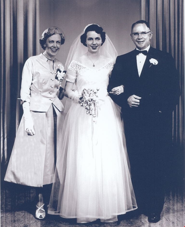
Francis Rumble with Katherine and Sidney Cumbers
https://search.heritageburnaby.ca/link/museumdescription2632
- Repository
- Burnaby Village Museum
- Date
- June 30, 1954 (date of original)
- Collection/Fonds
- Burnaby Village Museum Photograph collection
- Description Level
- Item
- Physical Description
- 1 photograph : b&w ; 300 ppi
- Scope and Content
- Photograph of Katherine Ann Rumble Cumbers and Sidney Cumbers on their wedding day with Katherine's mother, Francis Rumble.
- Repository
- Burnaby Village Museum
- Collection/Fonds
- Burnaby Village Museum Photograph collection
- Description Level
- Item
- Physical Description
- 1 photograph : b&w ; 300 ppi
- Scope and Content
- Photograph of Katherine Ann Rumble Cumbers and Sidney Cumbers on their wedding day with Katherine's mother, Francis Rumble.
- Subjects
- Ceremonies - Weddings
- Geographic Access
- New Westminster
- Accession Code
- BV004.115.14
- Access Restriction
- No restrictions
- Date
- June 30, 1954 (date of original)
- Media Type
- Photograph
- Notes
- Title based on contents of photograph
Images

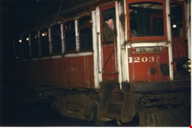
Interurban Car 1203
https://search.heritageburnaby.ca/link/museumdescription11208
- Repository
- Burnaby Village Museum
- Date
- 18 Nov. 1956
- Collection/Fonds
- George Bergson fonds
- Description Level
- Item
- Physical Description
- 1 photograph : col. ; 10 x 15 cm
- Scope and Content
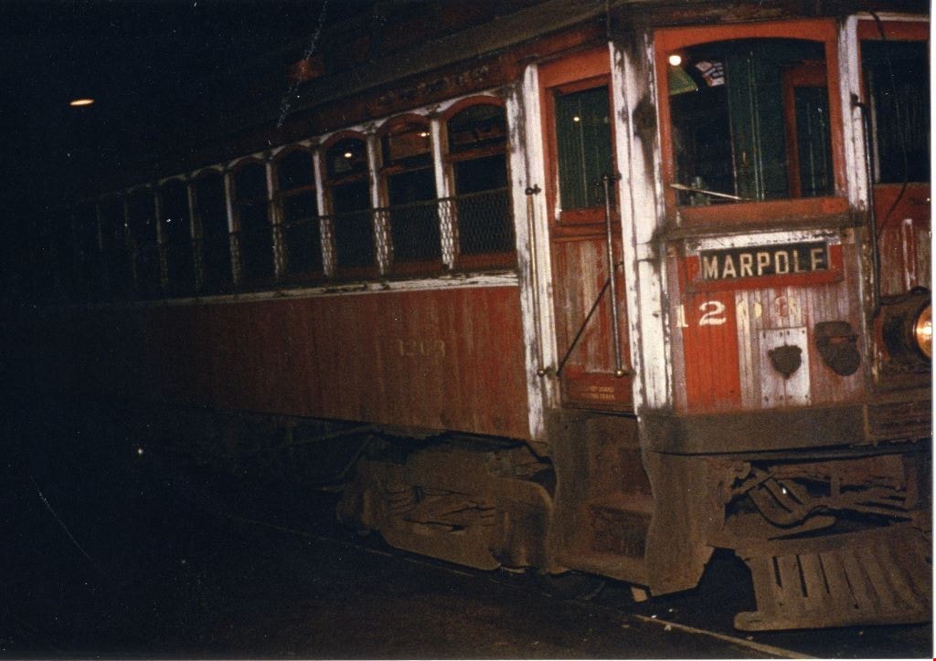
- Photograph of the Interurban Car 1203. The car is about to leave New Westminster depot at 12:30 am on Sunday November 18, 1956 on it's way to Marpole station. The front of the tram car displays the sign "Marpole". This was the very last run that this interurban car made through Burnaby.
- Repository
- Burnaby Village Museum
- Collection/Fonds
- George Bergson fonds
- Description Level
- Item
- Physical Description
- 1 photograph : col. ; 10 x 15 cm
- Scope and Content
- Photograph of the Interurban Car 1203. The car is about to leave New Westminster depot at 12:30 am on Sunday November 18, 1956 on it's way to Marpole station. The front of the tram car displays the sign "Marpole". This was the very last run that this interurban car made through Burnaby.
- History
- Photograph number four in a series of five photographs taken by George Bergson. Photographer, George Bergson and transportaion historian, Henry Ewert, were the last people to take this historic ride when train service ended.
- Subjects
- Transportation - Electric Railroads
- Geographic Access
- New Westminster
- Accession Code
- BV019.46.4
- Access Restriction
- No restrictions
- Reproduction Restriction
- No known restrictions
- Date
- 18 Nov. 1956
- Media Type
- Photograph
- Scan Resolution
- 600
- Scan Date
- 27-Sep-19
- Photographer
- Bergson, George
- Notes
- Title based on contents of photograph
- Note in black ink on verso reads: "George Bergson photo / Henry Ewert collection / The last interurban tram / to run in Burnaby, / car 1203, about to / leave New Westminster / for Marpole / at 12:30 am / on Sunday,November 18, / 1956. Service ended / with this run. / Tom Pritichard / motorman / Lawrence Love / conductor / interurban car 1203 / 4 of 5"
Images

Interurban Car 1203
https://search.heritageburnaby.ca/link/museumdescription11209
- Repository
- Burnaby Village Museum
- Date
- 18 Nov. 1956
- Collection/Fonds
- George Bergson fonds
- Description Level
- Item
- Physical Description
- 1 photograph : col. ; 10 x 15 cm
- Scope and Content
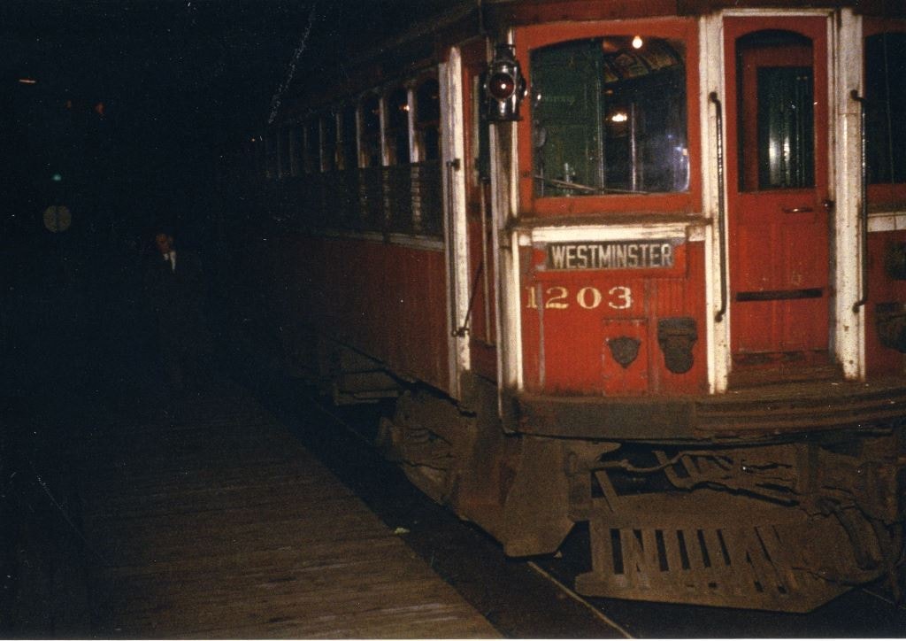
- Photograph of the Interurban Car 1203. The car is about to leave New Westminster depot at 12:30 am on Sunday November 18, 1956 on it's way to Marpole station. The back of the tram car displays the sign "Westminster". This was the very last run that this interurban car made through Burnaby.
- Repository
- Burnaby Village Museum
- Collection/Fonds
- George Bergson fonds
- Description Level
- Item
- Physical Description
- 1 photograph : col. ; 10 x 15 cm
- Scope and Content
- Photograph of the Interurban Car 1203. The car is about to leave New Westminster depot at 12:30 am on Sunday November 18, 1956 on it's way to Marpole station. The back of the tram car displays the sign "Westminster". This was the very last run that this interurban car made through Burnaby.
- History
- Photograph number five in a series of five photographs taken by George Bergson. Photographer, George Bergson and transportaion historian, Henry Ewert, were the last people to take this historic ride when train service ended.
- Subjects
- Transportation - Electric Railroads
- Geographic Access
- New Westminster
- Accession Code
- BV019.46.5
- Access Restriction
- No restrictions
- Reproduction Restriction
- No known restrictions
- Date
- 18 Nov. 1956
- Media Type
- Photograph
- Scan Resolution
- 600
- Scan Date
- 27-Sep-19
- Photographer
- Bergson, George
- Notes
- Title based on contents of photograph
- Note in black ink on verso reads: "George Bergson photo / Henry Ewert collection / The last interurban tram / to run in Burnaby, / car 1203, about to / leave New Westminster / for Marpole / at 12:30 am / on Sunday,November 18, / 1956. Service ended / with this run. / Tom Pritichard / motorman / Lawrence Love / conductor / interurban car 1203 / 5 of 5"
Images

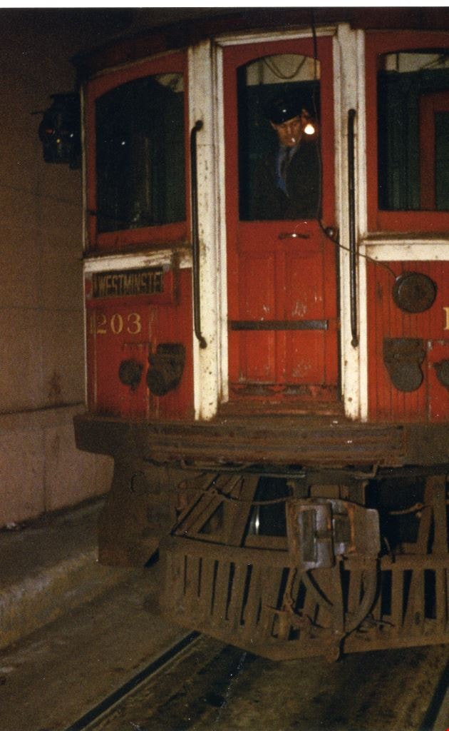
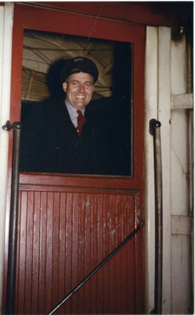
Lawrence Love on Interurban Car 1203
https://search.heritageburnaby.ca/link/museumdescription11205
- Repository
- Burnaby Village Museum
- Date
- 18 Nov. 1956
- Collection/Fonds
- George Bergson fonds
- Description Level
- Item
- Physical Description
- 1 photograph : col. ; 15 x 10 cm
- Scope and Content
- Photograph of the Interurban Car 1203 with conductor, Lawrence Love looking out the side door at the rear of the car. The sign "Westminster" is displayed on the outside. The car is about to leave New Westminster depot at 12:30 am on Sunday November 18, 1956. This was the very last run that this in…
- Repository
- Burnaby Village Museum
- Collection/Fonds
- George Bergson fonds
- Description Level
- Item
- Physical Description
- 1 photograph : col. ; 15 x 10 cm
- Scope and Content
- Photograph of the Interurban Car 1203 with conductor, Lawrence Love looking out the side door at the rear of the car. The sign "Westminster" is displayed on the outside. The car is about to leave New Westminster depot at 12:30 am on Sunday November 18, 1956. This was the very last run that this interurban car made through Burnaby.
- History
- Photograph is one in a series of five photographs taken by George Bergson. Photographer, George Bergson and transportaion historian, Henry Ewert, were the last people to take this historic ride.
- Subjects
- Transportation - Electric Railroads
- Names
- Love, Lawrence
- Geographic Access
- New Westminster
- Accession Code
- BV019.46.1
- Access Restriction
- No restrictions
- Reproduction Restriction
- No known restrictions
- Date
- 18 Nov. 1956
- Media Type
- Photograph
- Scan Resolution
- 600
- Scan Date
- 27-Sep-19
- Scale
- 100
- Photographer
- Bergson, George
- Notes
- Title based on contents of photograph
- Note in black ink on verso reads: "George Bergson photo / Henry Ewert collection / The last interurban / tram to run in / Burnaby, car 1203, / about to leave New / Westminster depot at / 12:30am., Sunday / November 18, 1956. / (Tom Pritichard - motorman / Lawrence Love - conductor) / 1203's final run was on / it's regular schedule , to Marpole. Service ended / with thi run" "1 of 5"
Images
Lawrence Love on Interurban Car 1203
https://search.heritageburnaby.ca/link/museumdescription11207
- Repository
- Burnaby Village Museum
- Date
- 18 Nov. 1956
- Collection/Fonds
- George Bergson fonds
- Description Level
- Item
- Physical Description
- 1 photograph : col. ; 15 x 10 cm
- Scope and Content
- Photograph of the Interurban Car 1203 with train conductor, Lawrence Love looking out the window of the door at the rear of the car. The car is about to leave New Westminster depot at 12:30 am on Sunday November 18, 1956. This was the very last run that this interurban car made through Burnaby.
- Repository
- Burnaby Village Museum
- Collection/Fonds
- George Bergson fonds
- Description Level
- Item
- Physical Description
- 1 photograph : col. ; 15 x 10 cm
- Scope and Content
- Photograph of the Interurban Car 1203 with train conductor, Lawrence Love looking out the window of the door at the rear of the car. The car is about to leave New Westminster depot at 12:30 am on Sunday November 18, 1956. This was the very last run that this interurban car made through Burnaby.
- History
- Photograph number three in a series of five photographs taken by George Bergson. Photographer, George Bergson and transportaion historian, Henry Ewert, were the last people to take this historic ride when train service ended.
- Subjects
- Transportation - Electric Railroads
- Names
- Love, Lawrence
- Geographic Access
- New Westminster
- Accession Code
- BV019.46.3
- Access Restriction
- No restrictions
- Reproduction Restriction
- No known restrictions
- Date
- 18 Nov. 1956
- Media Type
- Photograph
- Scan Resolution
- 600
- Scan Date
- 27-Sep-19
- Photographer
- Bergson, George
- Notes
- Title based on contents of photograph
- Note in black ink on verso reads: "George Bergson photo / Henry Ewert collection / The last interurban tram to / run in Burnaby, / car 1203, about to / leave New Westminster / for Marpole / at 12:30 am / on Sunday,November 18, / 1956. Service ended / with this run. / Tom Pritichard / motorman / Lawrence Love / was the conductor / interurban car 1203 / 3 of 5"
Images

Tom Pritchard on Interurban Car 1203
https://search.heritageburnaby.ca/link/museumdescription11206
- Repository
- Burnaby Village Museum
- Date
- 18 Nov. 1956
- Collection/Fonds
- George Bergson fonds
- Description Level
- Item
- Physical Description
- 1 photograph : col. ; 10 x 15 cm
- Scope and Content
- Photograph of the Interurban Car 1203 with motorman Tom Pritchard looking out the door at the rear of the car. The sign "Westminster" is displayed on the outside. The car is about to leave the New Westminster depot on it's way to Marpole station at 12:30 am on Sunday November 18, 1956. This was the…
- Repository
- Burnaby Village Museum
- Collection/Fonds
- George Bergson fonds
- Description Level
- Item
- Physical Description
- 1 photograph : col. ; 10 x 15 cm
- Scope and Content
- Photograph of the Interurban Car 1203 with motorman Tom Pritchard looking out the door at the rear of the car. The sign "Westminster" is displayed on the outside. The car is about to leave the New Westminster depot on it's way to Marpole station at 12:30 am on Sunday November 18, 1956. This was the very last run that this interurban car made through Burnaby.
- History
- Photograph number two in a series of five photographs taken by George Bergson. Photographer, George Bergson and transportaion historian, Henry Ewert, were the last people to take this historic ride when train service ended.
- Subjects
- Transportation - Electric Railroads
- Names
- Pritchard, Thomas
- Geographic Access
- New Westminster
- Accession Code
- BV019.46.2
- Access Restriction
- No restrictions
- Reproduction Restriction
- No known restrictions
- Date
- 18 Nov. 1956
- Media Type
- Photograph
- Scan Resolution
- 600
- Scan Date
- 27-Sep-19
- Photographer
- Bergson, George
- Notes
- Title based on contents of photograph
- Note in black ink on verso reads: "George Bergson photo / Henry Ewert collection / The last interurban tram to / run in Burnaby, car 1203, / about to leave New / Westminster for Marpole / at 12:30am on Sunday, / November 18, 1956. / Service ended with this run / Tom Pritichard - motorman / Lawrence Love was/ the conductor" / "2 of 5"
Images


Burnaby Lake Neighbourhood
https://search.heritageburnaby.ca/link/landmark821
- Repository
- Burnaby Heritage Planning
- Associated Dates
- 1955-2008
- Heritage Value
- In 1966 Burnaby Lake was identified as a key potential regional park in the GVRD ’s Regional Park Plan for the Lower Mainland. The lake was to be developed for nature study, strolling, trail riding, canoeing, sightseeing and picnicking. It was formally recognized as a regional nature park in 1979, at which time the GVRD assumed management of the park through a lease agreement with the City of Burnaby. In 1993 Burnaby Lake was selected by the City of Burnaby to be included in Greater Vancouver ’s Green Zone, and was identified as a key component of the GVRD ’s Park and Outdoor Recreation System (PORS) for the Burrard/Peninsula/Richmond sector, which includes Burnaby, Vancouver, New Westminster, and Richmond.
- Historic Neighbourhood
- Burnaby Lake (Historic Neighbourhood)
- Planning Study Area
- Burnaby Lake Area
Images


Edmonds Neighbourhood
https://search.heritageburnaby.ca/link/landmark704
- Repository
- Burnaby Heritage Planning
- Associated Dates
- 1925-1954
- Heritage Value
- The historic growth of Edmonds as a neighbourhood was based on its strategic location on the early interurban line between Vancouver and New Westminster. Even by 1980 when a survey of the residential neighbourhoods was conducted, a full 25% of homes in the area predated 1930. The 1950s was a period of strong housing development, with both single-family and multi-family units being constructed. Although Burnaby's City Hall was moved from Kingsway and Edmonds in the early 1950s, Edmonds remained an important centre in the community.
- Historic Neighbourhood
- Edmonds (Historic Neighbourhood)
- Planning Study Area
- Stride Avenue Area
Images


Stride Avenue Neighbourhood
https://search.heritageburnaby.ca/link/landmark845
- Repository
- Burnaby Heritage Planning
- Associated Dates
- 1955-2008
- Heritage Value
- The interurban link between New Westminster and Vancouver stimulated the early settlement of Stride Avenue. Infilling of the area took place in the early 1950s and the pace of development had slowed considerably by 1970. Duplexes became a popular feature in the decade between 1970 and 1980 and in the late 1980s, the neighbourhood was incorporated into the Edmonds Town Centre South plan.
- Historic Neighbourhood
- Edmonds (Historic Neighbourhood)
- Planning Study Area
- Stride Avenue Area
Images


North Burnaby Cenotaph
https://search.heritageburnaby.ca/link/landmark550
- Repository
- Burnaby Heritage Planning
- Description
- The North Burnaby Cenotaph is located in Confederation Park at the north end of the park on axis with the adjacent sports oval. The form of the memorial is of an obelisk atop a solid rectangular base, adorned with plaques commemorating those lost in the First World War, Second World War and the Kor…
- Associated Dates
- 1953
- Formal Recognition
- Heritage Designation, Community Heritage Register
- Repository
- Burnaby Heritage Planning
- Geographic Access
- Willingdon Avenue
- Associated Dates
- 1953
- Formal Recognition
- Heritage Designation, Community Heritage Register
- Enactment Type
- Bylaw No. 9807
- Enactment Date
- 23/11/1992
- Description
- The North Burnaby Cenotaph is located in Confederation Park at the north end of the park on axis with the adjacent sports oval. The form of the memorial is of an obelisk atop a solid rectangular base, adorned with plaques commemorating those lost in the First World War, Second World War and the Korean War.
- Heritage Value
- Built in 1953 by stonemason and First World War Veteran, Walter Holmes Morrice, the cenotaph was erected by the North Burnaby Legion Post #148 and is one of four memorials to citizens of Burnaby whose lives were lost at war. Strategically placed in an active and vibrant public park that was dedicated in 1927 and is used for sports, family outings and social gatherings, the cenotaph celebrates the freedoms that soldiers gave their lives to protect. The cenotaph is still used as a memorial site and bears witness to annual Remembrance Day ceremonies. Built of irregular granite blocks, the cenotaph is a solid structure of modest ornamentation that visually anchors the north end of the park. The site of the cenotaph and its adjacent gardens are surrounded by a simple barrier of continuous chain supported by low metal fence posts, providing a sense of solemnity and ceremony to the site.
- Defining Elements
- The character-defining elements of the North Burnaby Cenotaph include its: - axial location in the park and setting among active municipal facilities such as a school and library - strong symmetry of massing and design - obelisk form set atop a rectangular base - limited palette of materials - random coursed granite used as primary building material - bronze plaques commemorating the First and Second World Wars and the Korean War - surrounding pathways and flowerbeds
- Historic Neighbourhood
- Capitol Hill (Historic Neighbourhood)
- Planning Study Area
- Capitol Hill Area
- Organization
- North Burnaby Legion Post #148
- Builder
- Walter Holmes Morrice
- Function
- Primary Current--Park Fixture
- Primary Historic--Park Fixture
- Community
- Burnaby
- Cadastral Identifier
- P.I.D. No. 017-040-752 Legal Description: Parcel 1, District Lots 122 and 188, Group 1, New Westminster District, Plan NWP87902
- Boundaries
- The property (Confederation Park) is comprised of a single municipally-owned property located at 250 Willingdon Avenue, Burnaby.
- Area
- 184,160.00
- Contributing Resource
- Landscape Feature
- Structure
- Ownership
- Public (local)
- Documentation
- Heritage Site Files: PC77000 20. City of Burnaby Planning and Building Department, 4949 Canada Way, Burnaby, B.C., V5G 1M2
- Street Address
- 250 Willingdon Avenue
Images
