Narrow Results By
Decade
- 2020s 57
- 2010s 122
- 2000s 241
- 1990s 372
- 1980s 299
- 1970s 423
- 1960s 340
- 1950s 382
- 1940s 384
- 1930s 502
- 1920s
- 1910s 277
- 1900s 116
- 1890s 34
- 1880s 9
- 1870s 7
- 1860s
- 1850s 4
- 1840s 3
- 1830s 2
- 1820s 2
- 1810s 2
- 1800s 2
- 1790s 1
- 1780s 1
- 1770s
- 1760s 1
- 1750s 1
- 1740s 1
- 1730s 1
- 1720s 1
- 1710s 1
- 1700s 1
- 1690s 1
- 1680s 1
- 1670s 1
- 1660s 1
- 1650s 1
- 1640s 1
- 1630s 1
- 1620s 1
- 1610s 1
- 1600s 1
Creator
- Bingham, Alfred "Alf" 2
- Blake, Frederick "Fred" 1
- Bridgman's Studio Limited 3
- British Columbia Underwriters' Association 5
- Bullen, Harry Elder 1
- Burnaby Village Museum 6
- Burnett & McGugan, Engineers and Surveyors 1
- Campbell Studios Limited 1
- Charlton and Rathburn 3
- Coast Map and Blue Print Co. 1
- Damer, Eric 1
- Dominion Map and Blueprint Co. 1

Aeroplane view of the Barnet Lumber Co.
https://search.heritageburnaby.ca/link/archivedescription38679
- Repository
- City of Burnaby Archives
- Date
- 1927
- Collection/Fonds
- Burnaby Historical Society fonds
- Description Level
- Item
- Physical Description
- 1 photograph : sepia postcard ; 8.9 x 13.4 cm
- Scope and Content
- Aerial photographic postcard of Barnet Lumber Company's Mill. The handwritten caption on the lower left corner of the postcard reads: "Aeroplane view of the Barnet Lumber Co. Ltd./ Barnet BC." The handwritten caption on the lower right corner reads: "Copyright 1927/ Pacific Airway Ltd./ Vancouver …
- Repository
- City of Burnaby Archives
- Date
- 1927
- Collection/Fonds
- Burnaby Historical Society fonds
- Subseries
- North Burnaby Board of Trade subseries
- Physical Description
- 1 photograph : sepia postcard ; 8.9 x 13.4 cm
- Description Level
- Item
- Record No.
- 476-022
- Access Restriction
- No restrictions
- Reproduction Restriction
- No known restrictions
- Accession Number
- BHS2005-8
- Scope and Content
- Aerial photographic postcard of Barnet Lumber Company's Mill. The handwritten caption on the lower left corner of the postcard reads: "Aeroplane view of the Barnet Lumber Co. Ltd./ Barnet BC." The handwritten caption on the lower right corner reads: "Copyright 1927/ Pacific Airway Ltd./ Vancouver B.C.".
- Subjects
- Aerial Photographs
- Industries - Forestry
- Buildings - Industrial - Mills
- Documentary Artifacts - Postcards
- Industries - Logging/lumber
- Names
- Barnet Mill
- Media Type
- Photograph
- Photographer
- Pacific Airway Ltd.
- Responsibility
- Published by the Gowen, Sutton Co. Ltd., Vancouver
- Notes
- Transcribed title
- Geographic Access
- Barnet Village
- Texaco Drive
- Street Address
- 8059 Texaco Drive
- Historic Neighbourhood
- Barnet (Historic Neighbourhood)
- Planning Study Area
- Burnaby Mountain Area
Images


Commercial Map of Greater Vancouver and District
https://search.heritageburnaby.ca/link/museumdescription9552
- Repository
- Burnaby Village Museum
- Date
- July 1921
- Collection/Fonds
- Burnaby Village Museum Map collection
- Description Level
- Item
- Physical Description
- 1 map : col. lithograph mounted on linen ; 107 x 138 cm
- Scope and Content
- Commercial map of Greater Vancouver and District. Map depicts district lots, railroads, electric railways, streets, street car stops, schools, buildings, postal block numbers, parks and First Nations reserves. Map covers the geographcial areas of Vancouver, Burnaby, New Westminster, portions of Ric…
- Repository
- Burnaby Village Museum
- Collection/Fonds
- Burnaby Village Museum Map collection
- Description Level
- Item
- Physical Description
- 1 map : col. lithograph mounted on linen ; 107 x 138 cm
- Material Details
- Includes Legend and Index
- Scope and Content
- Commercial map of Greater Vancouver and District. Map depicts district lots, railroads, electric railways, streets, street car stops, schools, buildings, postal block numbers, parks and First Nations reserves. Map covers the geographcial areas of Vancouver, Burnaby, New Westminster, portions of Richmond, West Vancouver, North Vancouver, and Surrey with half mile circles that radiate from Vancouver City Hall on the corner of Main and Hastings. Bottom of map includes an index of street names, along with their corresponding map grid locations. The map is bordered by Marine Drive to the west, North Road to the east, Dempsey Street to the north and 20th Road to the south.
- History
- Bought by donor at thrift store years ago. No known provenance.
- Publisher
- Produced by Photo - Lithography, Colonist , Victoria, B.C.
- Geographic Access
- Vancouver
- Accession Code
- BV018.24.1
- Access Restriction
- No restrictions
- Reproduction Restriction
- No known restrictions
- Date
- July 1921
- Media Type
- Cartographic Material
- Scan Resolution
- 300
- Scan Date
- 16-Jun-20
- Scale
- 100
- Notes
- Transcribed title
- Title on map reads: "COMMERCIAL MAP / OF / GREATER VANCOUVER / AND / DISTRICT / Compiled and Published by / The Vancouver Map & Blueprint Co. Ltd. / 441 Seymour St. Vancouver B.C. / July, 1921".
Images

![Indexed guide map of the City of Vancouver and suburbs, [1920] thumbnail](/media/hpo/_Data/_BVM_Cartographic_Material/1975/1975_0061_0013_001.jpg?width=280)
Indexed guide map of the City of Vancouver and suburbs
https://search.heritageburnaby.ca/link/museumdescription8678
- Repository
- Burnaby Village Museum
- Date
- [1920]
- Collection/Fonds
- Burnaby Village Museum Map collection
- Description Level
- Item
- Physical Description
- 1 map + textual record : col. lithographic print on paper ; 51.5 x 71 cm folded to 21 x 10 cm
- Scope and Content
- Item consists of a fold out map entitled "Indexed Guide Map of Vancouver and Suburbs" with index. Map includes concentric circles raditating out from Vancouver City Hall on corner of Hastings Street and Main Street; electric railways are indicated by heavy red lines in centres of streets. Includes …
- Repository
- Burnaby Village Museum
- Collection/Fonds
- Burnaby Village Museum Map collection
- Description Level
- Item
- Physical Description
- 1 map + textual record : col. lithographic print on paper ; 51.5 x 71 cm folded to 21 x 10 cm
- Material Details
- Scale [1:47520]
- Index on 4 pages within cardstock cover with advertisements on verso
- Scope and Content
- Item consists of a fold out map entitled "Indexed Guide Map of Vancouver and Suburbs" with index. Map includes concentric circles raditating out from Vancouver City Hall on corner of Hastings Street and Main Street; electric railways are indicated by heavy red lines in centres of streets. Includes old and new street names. Index includes a District Lot Index and Street Index.
- Publisher
- Vancouver Map and Blue Print Company
- Accession Code
- HV975.61.13
- Access Restriction
- No restrictions
- Reproduction Restriction
- No known restrictions
- Date
- [1920]
- Media Type
- Cartographic Material
- Textual Record
- Publisher Series
- 6th edition revised June 1920
- Scan Resolution
- 600
- Scan Date
- 2023-11-10
- Notes
- Title based on contents of map
- Cover of booklet reads: "INDEXED / Guide Map / of the CITY of / VANCOUVER / and / SUBURBS / Compiled and Published by / The Vancouver Map & Blue Print Co. / ...."INTERNATIONAL / BOOK SHOP / Cor. Columbia and Hastings Sts._Vancouver, B.C.".
Documents
Zoomable Images
![Indexed guide map of the City of Vancouver and suburbs, [1920] thumbnail](/media/hpo/_Data/_BVM_Cartographic_Material/1975/1975_0061_0013_002_seadragon/1975_0061_0013_002.jpg?w=280)
![Bateman family parlour in Vancouver, [1920 or 1921] thumbnail](/media/hpo/_Data/_BVM_Images/2000/200400280002.jpg?width=280)
Bateman family parlour in Vancouver
https://search.heritageburnaby.ca/link/museumdescription1758
- Repository
- Burnaby Village Museum
- Date
- [1920 or 1921]
- Collection/Fonds
- E.W. Bateman family fonds
- Description Level
- Item
- Physical Description
- 1 photograph : sepia ; 6 x 12 cm
- Scope and Content
- Photograph of the Bateman family parlour at 2976 7th West Avenue in Vancouver.
- Repository
- Burnaby Village Museum
- Collection/Fonds
- E.W. Bateman family fonds
- Description Level
- Item
- Physical Description
- 1 photograph : sepia ; 6 x 12 cm
- Scope and Content
- Photograph of the Bateman family parlour at 2976 7th West Avenue in Vancouver.
- Geographic Access
- Vancouver
- Accession Code
- BV004.28.2
- Access Restriction
- No restrictions
- Reproduction Restriction
- No known restrictions
- Date
- [1920 or 1921]
- Media Type
- Photograph
- Scan Resolution
- 600
- Scan Date
- 09-Jun-09
- Scale
- 100
- Notes
- Title based on contents of photograph
- Notes on verso of photograph read: "Parlor" and "2976 - 7th. W"
Images
![Bateman family parlour in Vancouver, [1920 or 1921] thumbnail](/media/hpo/_Data/_BVM_Images/2000/200400280002.jpg)
![Central Park Auto Tourist Grounds, Vancouver Canada, [1923] thumbnail](/media/hpo/_Data/_Archives_Images/_Unrestricted/371/449-007.jpg?width=280)
Central Park Auto Tourist Grounds, Vancouver Canada
https://search.heritageburnaby.ca/link/archivedescription38512
- Repository
- City of Burnaby Archives
- Date
- [1923]
- Collection/Fonds
- Burnaby Historical Society fonds
- Description Level
- Item
- Physical Description
- 1 photograph : sepia postcard ; 9 x 14 cm
- Scope and Content
- Photographic postcard of the Central Park auto tourist grounds. Two unidentified men can be seen standing in front of a car which is parked next to the campground building. In the background, a clothesline has been strung holding towels and blankets.
- Repository
- City of Burnaby Archives
- Date
- [1923]
- Collection/Fonds
- Burnaby Historical Society fonds
- Subseries
- Photographs subseries
- Physical Description
- 1 photograph : sepia postcard ; 9 x 14 cm
- Description Level
- Item
- Record No.
- 449-007
- Access Restriction
- No restrictions
- Reproduction Restriction
- No known restrictions
- Accession Number
- BHS2007-04
- Scope and Content
- Photographic postcard of the Central Park auto tourist grounds. Two unidentified men can be seen standing in front of a car which is parked next to the campground building. In the background, a clothesline has been strung holding towels and blankets.
- Subjects
- Buildings - Commercial - Hotels and Motels
- Geographic Features - Parks
- Documentary Artifacts - Postcards
- Recreational Activities - Camping
- Media Type
- Photograph
- Notes
- Title based on caption
- Geographic Access
- Central Park
- Imperial Street
- Street Address
- 3883 Imperial Street
- Historic Neighbourhood
- Central Park (Historic Neighbourhood)
- Planning Study Area
- Maywood Area
Images
![Central Park Auto Tourist Grounds, Vancouver Canada, [1923] thumbnail](/media/hpo/_Data/_Archives_Images/_Unrestricted/371/449-007.jpg)
The City of Vancouver B.C.
https://search.heritageburnaby.ca/link/archivedescription66103
- Repository
- City of Burnaby Archives
- Date
- [between 1916 and 1929]
- Collection/Fonds
- Burnaby Historical Society fonds
- Description Level
- Item
- Physical Description
- 1 map : b&w ink on paper ; 56 x 107 cm folded to 21 x 12.5 cm
- Scope and Content
- Item is a map of "[the] City of Vancouver B.C" drawn prior to amalgamation of Point Grey and South Vancouver with the City of Vancouver.
- Repository
- City of Burnaby Archives
- Date
- [between 1916 and 1929]
- Collection/Fonds
- Burnaby Historical Society fonds
- Subseries
- Ephemera subseries
- Physical Description
- 1 map : b&w ink on paper ; 56 x 107 cm folded to 21 x 12.5 cm
- Material Details
- Map has a blue construction paper cover
- Scale : 1 inch = 1000 feet
- Description Level
- Item
- Record No.
- 42707
- Accession Number
- BHS2007-04
- Scope and Content
- Item is a map of "[the] City of Vancouver B.C" drawn prior to amalgamation of Point Grey and South Vancouver with the City of Vancouver.
- Media Type
- Cartographic Material
- Notes
- Transcribed title
![The Dominion leaving Vancouver, [after 1921] thumbnail](/media/hpo/_Data/_BVM_Images/1985/1985_6114_0028_001.jpg?width=280)
The Dominion leaving Vancouver
https://search.heritageburnaby.ca/link/museumdescription3256
- Repository
- Burnaby Village Museum
- Date
- [after 1921]
- Collection/Fonds
- Burnaby Village Museum Photograph collection
- Description Level
- Item
- Physical Description
- 1 photograph : b&w ; 8 x 5.5 cm
- Scope and Content
- Photograph of Canadian Pacific Railway steam locomotive no. 2717 (built in 1921) "The Dominion" leaving Vancouver.
- Repository
- Burnaby Village Museum
- Collection/Fonds
- Burnaby Village Museum Photograph collection
- Description Level
- Item
- Physical Description
- 1 photograph : b&w ; 8 x 5.5 cm
- Scope and Content
- Photograph of Canadian Pacific Railway steam locomotive no. 2717 (built in 1921) "The Dominion" leaving Vancouver.
- Geographic Access
- Vancouver
- Accession Code
- BV985.6114.28
- Access Restriction
- No restrictions
- Reproduction Restriction
- No known restrictions
- Date
- [after 1921]
- Media Type
- Photograph
- Scan Resolution
- 600
- Scan Date
- 2024-03-12
- Notes
- Title based on note written on verso of photograph
- Handwritten note in black ball-point pen on verso of photograph reads: "The Dominion/ leaving Van/ CP 2717"
- Stamp on verso of photograph reads: "48"
Images
![The Dominion leaving Vancouver, [after 1921] thumbnail](/media/hpo/_Data/_BVM_Images/1985/1985_6114_0028_001.jpg)
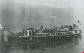
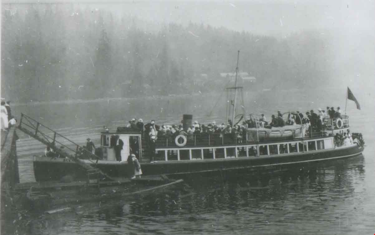
Ferry from Port Moody to Vancouver
https://search.heritageburnaby.ca/link/archivedescription37706
- Repository
- City of Burnaby Archives
- Date
- 1923 (date of original), copied 1991
- Collection/Fonds
- Burnaby Historical Society fonds
- Description Level
- Item
- Physical Description
- 1 photograph : b&w ; 3.3 x 5.1 cm print on contact sheet 20.2 x 25.3 cm
- Scope and Content
- Photograph of the "scenic" ferry from Port Moody to Vancouver through the Burrard Inlet.
- Repository
- City of Burnaby Archives
- Date
- 1923 (date of original), copied 1991
- Collection/Fonds
- Burnaby Historical Society fonds
- Subseries
- Burnaby Image Bank subseries
- Physical Description
- 1 photograph : b&w ; 3.3 x 5.1 cm print on contact sheet 20.2 x 25.3 cm
- Description Level
- Item
- Record No.
- 370-294
- Access Restriction
- No restrictions
- Reproduction Restriction
- No known restrictions
- Accession Number
- BHS1999-03
- Scope and Content
- Photograph of the "scenic" ferry from Port Moody to Vancouver through the Burrard Inlet.
- Media Type
- Photograph
- Notes
- Title based on contents of photograph
- 1 b&w copy negative accompanying
- Historic Neighbourhood
- Barnet (Historic Neighbourhood)
- Planning Study Area
- Burnaby Mountain Area
Images

Fire insurance key plan - Greater Vancouver - Volume XIX - Municipality of Burnaby
https://search.heritageburnaby.ca/link/museumdescription17799
- Repository
- Burnaby Village Museum
- Date
- 1927
- Collection/Fonds
- Burnaby Village Museum Map collection
- Description Level
- Item
- Physical Description
- 1 plan on 1 sheet : col. lithographic print ; 64 x 54 cm
- Scope and Content
- Item consists of a one page fire insurance key plan titled "Greater Vancouver / Volume XIX / Municipality / of Burnaby / Key Plan" surveyed May 1927. Key plan from compilation, "Insurance Plans of Greater Vancouver Plan No. 11, Volumes 15 to 19 Burnaby".
- Repository
- Burnaby Village Museum
- Collection/Fonds
- Burnaby Village Museum Map collection
- Description Level
- Item
- Physical Description
- 1 plan on 1 sheet : col. lithographic print ; 64 x 54 cm
- Material Details
- Scale [1:6000]
- Scope and Content
- Item consists of a one page fire insurance key plan titled "Greater Vancouver / Volume XIX / Municipality / of Burnaby / Key Plan" surveyed May 1927. Key plan from compilation, "Insurance Plans of Greater Vancouver Plan No. 11, Volumes 15 to 19 Burnaby".
- Publisher
- Plan Department of Fire Branch of British Columbia Underwriters' Association
- Accession Code
- BV987.1.70
- Access Restriction
- No restrictions
- Reproduction Restriction
- May be restricted by third party rights
- Date
- 1927
- Media Type
- Cartographic Material
- Historic Neighbourhood
- Fraser Arm (Historic Neighbourhood)
- Planning Study Area
- Big Bend Area
- Scan Resolution
- 400
- Scan Date
- 2021-11-17
- Notes
- Title based on contents of item
- Scale 500 feet = 1 inch
- These plans were removed from a bound book with labels on cover page reading: "Plan No. 90 / THIS INSURANCE PLAN / of / Vancouver VOLUME "8" / IN THE PROPERTY OF THE / British Columbia Insurance Underwriter's Association / Vancouver B.C. / AND IS LOANED / MELVILLE F. THOMSON CO. .../ Date May 26th, 1934"; / "Plan No. 74 / THIS INSURANCE PLAN / OF / VANCOUVER VOLUME "9"" / Plan No. 11 / THIS INSURANCE PLAN / OF / BURNABY VOLUMES 15-19" / "THIS PLAN IS THE PROPERTY OF / THE / BRITISH LAW INSURANCE COMPANY / LIMITED"
- Does not include the corresponding key plan page or associated plans numbered 1901 to 1914
- Contact Burnaby Village Museum to view associated fire insurance plans
Zoomable Images

Fire insurance key plan - Greater Vancouver - Volume XIX - Municipality of Burnaby, 1927
Zoom into Image
Fire insurance key plan - Greater Vancouver - Volume XVI - Municipality of Burnaby
https://search.heritageburnaby.ca/link/museumdescription17796
- Repository
- Burnaby Village Museum
- Date
- 1927
- Collection/Fonds
- Burnaby Village Museum Map collection
- Description Level
- Item
- Physical Description
- 2 plans on 2 sheets: col. lithographic print ; 64 x 54 cm
- Scope and Content
- Item consists of a two page fire insurance key plan titled "Greater Vancouver / Volume XVI / Municipality / of Burnaby / Key Plan" surveyed May 1927. Volume XVI includes a two page Key Plan (C and D). .
- Repository
- Burnaby Village Museum
- Collection/Fonds
- Burnaby Village Museum Map collection
- Description Level
- Item
- Physical Description
- 2 plans on 2 sheets: col. lithographic print ; 64 x 54 cm
- Scope and Content
- Item consists of a two page fire insurance key plan titled "Greater Vancouver / Volume XVI / Municipality / of Burnaby / Key Plan" surveyed May 1927. Volume XVI includes a two page Key Plan (C and D). .
- Publisher
- Plan Department of Fire Branch of British Columbia Underwriters Association
- Accession Code
- BV987.1.70
- Access Restriction
- No restrictions
- Reproduction Restriction
- May be restricted by third party rights
- Date
- 1927
- Media Type
- Cartographic Material
- Scan Resolution
- 400
- Scan Date
- 11/17/2021
- Notes
- Title based on contents of item
- Item "GREATER VANCOUVER / VOLUME XVI / MUNICIPALITY OF / BURNABY / KEY PLAN" does not include associated numbered plans (1601 to 1651)
- These plans were removed from a bound book with labels on cover page reading: "Plan No. 90 / THIS INSURANCE PLAN / of / Vancouver VOLUME "8" / IN THE PROPERTY OF THE / British Columbia Insurance Underwriter's Association / Vancouver B.C. / AND IS LOANED / MELVILLE F. THOMSON CO. .../ Date May 26th, 1934"; / "Plan No. 74 / THIS INSURANCE PLAN / OF / VANCOUVER VOLUME "9"" / Plan No. 11 / THIS INSURANCE PLAN / OF / BURNABY VOLUMES 15-19" / "THIS PLAN IS THE PROPERTY OF / THE / BRITISH LAW INSURANCE COMPANY / LIMITED"
Zoomable Images

Fire insurance key plan - Greater Vancouver - Volume XVI - Municipality of Burnaby, 1927
Zoom into Image
Fire insurance plans - Greater Vancouver - Volume XVIII - Municipality of Burnaby
https://search.heritageburnaby.ca/link/museumdescription17798
- Repository
- Burnaby Village Museum
- Date
- 1927-1950
- Collection/Fonds
- Burnaby Village Museum Map collection
- Description Level
- Item
- Physical Description
- 22 plans on 12 sheets : col. lithographic print ; 64 x 54 cm
- Scope and Content
- Item consists of fire insurance plans titled "Greater Vancouver / Volume XVIII / Municipality / of Burnaby" surveyed May 1927, revised in October 1940 and September 1950. Includes a two page key plan (G and H) and twenty associated plans numbered; 1801; 1802; 1803; 1804; 1805; 1806; 1807; 1808; 18…
- Repository
- Burnaby Village Museum
- Collection/Fonds
- Burnaby Village Museum Map collection
- Description Level
- Item
- Physical Description
- 22 plans on 12 sheets : col. lithographic print ; 64 x 54 cm
- Material Details
- Scales between [1:600] and [1:6000]
- Scope and Content
- Item consists of fire insurance plans titled "Greater Vancouver / Volume XVIII / Municipality / of Burnaby" surveyed May 1927, revised in October 1940 and September 1950. Includes a two page key plan (G and H) and twenty associated plans numbered; 1801; 1802; 1803; 1804; 1805; 1806; 1807; 1808; 1809; 1810; 1811; 1812; 1813; 1814; 1815; 1819; 1820; 1821; 1822 and 1832.
- Publisher
- Plan Department of Fire Branch of British Columbia Underwriters' Association
- Accession Code
- BV987.1.70
- Access Restriction
- No restrictions
- Reproduction Restriction
- May be restricted by third party rights
- Date
- 1927-1950
- Media Type
- Cartographic Material
- Scan Resolution
- 400
- Scan Date
- 11/17/2021
- Notes
- Title based on contents of item
- Scale 1 inch = 50 feet
- These plans were removed from a bound book with labels on cover page reading: "Plan No. 90 / THIS INSURANCE PLAN / of / Vancouver VOLUME "8" / IN THE PROPERTY OF THE / British Columbia Insurance Underwriter's Association / Vancouver B.C. / AND IS LOANED / MELVILLE F. THOMSON CO. .../ Date May 26th, 1934"; / "Plan No. 74 / THIS INSURANCE PLAN / OF / VANCOUVER VOLUME "9"" / Plan No. 11 / THIS INSURANCE PLAN / OF / BURNABY VOLUMES 15-19" / "THIS PLAN IS THE PROPERTY OF / THE / BRITISH LAW INSURANCE COMPANY / LIMITED"
- Contact Burnaby Village Museum to view associated fire insurance plans
Fire insurance plans - Greater Vancouver - Volume XVII - Municipality of Burnaby
https://search.heritageburnaby.ca/link/museumdescription17797
- Repository
- Burnaby Village Museum
- Date
- 1927-1950
- Collection/Fonds
- Burnaby Village Museum Map collection
- Description Level
- Item
- Physical Description
- 4 plans on 4 sheets : col. lithographic prints
- Scope and Content
- Item consists of fire insurance plans titled "Greater Vancouver / Volume XVII / Municipality / of Burnaby" surveyed May 1927, revised in October 1940 and September 1950. Includes a two page key plan (E and F) and two associated plans numbered 1729 and 1738 (located within District Lot 35).
- Repository
- Burnaby Village Museum
- Collection/Fonds
- Burnaby Village Museum Map collection
- Description Level
- Item
- Physical Description
- 4 plans on 4 sheets : col. lithographic prints
- Scope and Content
- Item consists of fire insurance plans titled "Greater Vancouver / Volume XVII / Municipality / of Burnaby" surveyed May 1927, revised in October 1940 and September 1950. Includes a two page key plan (E and F) and two associated plans numbered 1729 and 1738 (located within District Lot 35).
- Publisher
- Plan Department of Fire Branch of British Columbia Underwriters' Association
- Accession Code
- BV987.1.70
- Access Restriction
- No restrictions
- Reproduction Restriction
- May be restricted by third party rights
- Date
- 1927-1950
- Media Type
- Cartographic Material
- Historic Neighbourhood
- Central Park (Historic Neighbourhood)
- Planning Study Area
- Garden Village Area
- Scan Resolution
- 400
- Scan Date
- 2021-11-17
- Notes
- Title based on contents of item
- These plans were removed from a bound book with labels on cover page reading: "Plan No. 90 / THIS INSURANCE PLAN / of / Vancouver VOLUME "8" / IN THE PROPERTY OF THE / British Columbia Insurance Underwriter's Association / Vancouver B.C. / AND IS LOANED / MELVILLE F. THOMSON CO. .../ Date May 26th, 1934"; / "Plan No. 74 / THIS INSURANCE PLAN / OF / VANCOUVER VOLUME "9"" / Plan No. 11 / THIS INSURANCE PLAN / OF / BURNABY VOLUMES 15-19" / "THIS PLAN IS THE PROPERTY OF / THE / BRITISH LAW INSURANCE COMPANY / LIMITED"
- Contact Burnaby Village Museum to view associated fire insurance plans XVIII
Fire insurance plans - Greater Vancouver - Volume XV - Municipality of Burnaby
https://search.heritageburnaby.ca/link/museumdescription17795
- Repository
- Burnaby Village Museum
- Date
- 1927-1940
- Collection/Fonds
- Burnaby Village Museum Map collection
- Description Level
- Item
- Physical Description
- 11 plans on 8 sheets : col. lithographic print ; 64 x 54 cm
- Scope and Content
- Item consists of fire insurance plans titled "Greater Vancouver / Volume XV / Municipality / of Burnaby" surveyed May 1927 and revised October 1940. Volume XV includes a two page Key Plan (A and B) identifying associated plan numbers and district lots and nine numbered fire insurance plans identifi…
- Repository
- Burnaby Village Museum
- Collection/Fonds
- Burnaby Village Museum Map collection
- Description Level
- Item
- Physical Description
- 11 plans on 8 sheets : col. lithographic print ; 64 x 54 cm
- Material Details
- Scales between [1:600] and [1:6000]
- Scope and Content
- Item consists of fire insurance plans titled "Greater Vancouver / Volume XV / Municipality / of Burnaby" surveyed May 1927 and revised October 1940. Volume XV includes a two page Key Plan (A and B) identifying associated plan numbers and district lots and nine numbered fire insurance plans identified as; 1507; 1508 ; 1517; 1518; 1519; 1520;1521; 1531and 1532.
- Publisher
- Plan Department of Fire Branch of British Columbia Underwriters' Association
- Accession Code
- BV987.1.70
- Access Restriction
- No restrictions
- Reproduction Restriction
- May be restricted by third party rights
- Date
- 1927-1940
- Media Type
- Cartographic Material
- Historic Neighbourhood
- Vancouver Heights (Historic Neighbourhood)
- Planning Study Area
- Burnaby Heights Area
- Willingdon Heights Area
- Scan Resolution
- 400
- Notes
- Title based on contents of item
- These plans are contained within a bound book with labels on cover page reading: "Plan No. 90 / THIS INSURANCE PLAN / of / Vancouver VOLUME "8" / IN THE PROPERTY OF THE / British Columbia Insurance Underwriter's Association / Vancouver B.C. / AND IS LOANED / MELVILLE F. THOMSON CO. .../ Date May 26th, 1934"; / "Plan No. 74 / THIS INSURANCE PLAN / OF / VANCOUVER VOLUME "9"" / Plan No. 11 / THIS INSURANCE PLAN / OF / BURNABY VOLUMES 15-19" / "THIS PLAN IS THE PROPERTY OF / THE / BRITISH LAW INSURANCE COMPANY / LIMITED"
- Fire insurance plans cover various district lots in Burnaby including: District Lot 116,121, 186 and 187.
- Sticker adhered to Key Plan B reads: "
- Contact Burnaby Village Museum to view fire insurance plans that are part of Volume XV
General Relief Board - I.O.O.F. of Vancouver
https://search.heritageburnaby.ca/link/museumdescription9762
- Repository
- Burnaby Village Museum
- Date
- [ca. 1915]
- Collection/Fonds
- Hugh H. Stewart fonds
- Description Level
- Item
- Physical Description
- 1 textual record
- Scope and Content
- Item consists of a member card to certify Mr. H.H. Stewart as an accredited member of the General Relief Board, I.O.O.F. of Vancouver, B.C. The card is a visiting permit that allows the bearer to visit the Public or Semi-private Wards of the Vancouver General Hospital at any time. The card is signe…
- Repository
- Burnaby Village Museum
- Collection/Fonds
- Hugh H. Stewart fonds
- Description Level
- Item
- Physical Description
- 1 textual record
- Scope and Content
- Item consists of a member card to certify Mr. H.H. Stewart as an accredited member of the General Relief Board, I.O.O.F. of Vancouver, B.C. The card is a visiting permit that allows the bearer to visit the Public or Semi-private Wards of the Vancouver General Hospital at any time. The card is signed by the V.G.H. superintendent, Malcolm T. MacEachren.
- Names
- Stewart, Hugh Henry
- Accession Code
- HV979.50.271
- Access Restriction
- No restrictions
- Reproduction Restriction
- No known restrictions
- Date
- [ca. 1915]
- Media Type
- Textual Record
- Notes
- Title based on content of Item
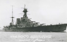
HMS Hood entering Vancouver Harbour
https://search.heritageburnaby.ca/link/archivedescription36983
- Repository
- City of Burnaby Archives
- Date
- 1924 (date of original), copied 1992
- Collection/Fonds
- Burnaby Historical Society fonds
- Description Level
- Item
- Physical Description
- 1 photograph : b&w ; 8.7 x 12.7 cm print
- Scope and Content
- Photograph of the HMS Hood entering Vancouver harbour, June 25, 1924. The bottom of the photo reads, "compliments of Crystal Finish Ltd."
- Repository
- City of Burnaby Archives
- Date
- 1924 (date of original), copied 1992
- Collection/Fonds
- Burnaby Historical Society fonds
- Subseries
- Burnaby Centennial Anthology subseries
- Physical Description
- 1 photograph : b&w ; 8.7 x 12.7 cm print
- Description Level
- Item
- Record No.
- 315-441
- Access Restriction
- No restrictions
- Reproduction Restriction
- No known restrictions
- Accession Number
- BHS1994-04
- Scope and Content
- Photograph of the HMS Hood entering Vancouver harbour, June 25, 1924. The bottom of the photo reads, "compliments of Crystal Finish Ltd."
- Subjects
- Transportation - Ships
- Names
- Crystal Finish Limited
- Media Type
- Photograph
- Notes
- Title based on contents of photograph
Images

![Homes in Vancouver Heights, [between 1925 and 1930] thumbnail](/media/hpo/_Data/_Archives_Images/_Unrestricted/371/476-006.jpg?width=280)
Homes in Vancouver Heights
https://search.heritageburnaby.ca/link/archivedescription38663
- Repository
- City of Burnaby Archives
- Date
- [between 1925 and 1930]
- Collection/Fonds
- Burnaby Historical Society fonds
- Description Level
- Item
- Physical Description
- 1 photograph : sepia ; 14.5 x 20.5 cm
- Scope and Content
- Photograph of a row of unidentified houses in the Vancouver Heights area.
- Repository
- City of Burnaby Archives
- Date
- [between 1925 and 1930]
- Collection/Fonds
- Burnaby Historical Society fonds
- Subseries
- North Burnaby Board of Trade subseries
- Physical Description
- 1 photograph : sepia ; 14.5 x 20.5 cm
- Description Level
- Item
- Record No.
- 476-006
- Access Restriction
- No restrictions
- Reproduction Restriction
- No known restrictions
- Accession Number
- BHS2005-8
- Scope and Content
- Photograph of a row of unidentified houses in the Vancouver Heights area.
- Subjects
- Buildings - Residential - Houses
- Media Type
- Photograph
- Notes
- Title based on contents of photograph.
- Historic Neighbourhood
- Vancouver Heights (Historic Neighbourhood)
- Planning Study Area
- Burnaby Heights Area
Images
![Homes in Vancouver Heights, [between 1925 and 1930] thumbnail](/media/hpo/_Data/_Archives_Images/_Unrestricted/371/476-006.jpg)
![Houses in Vancouver Heights, [between 1925 and 1930] thumbnail](/media/hpo/_Data/_Archives_Images/_Unrestricted/371/476-007.jpg?width=280)
Houses in Vancouver Heights
https://search.heritageburnaby.ca/link/archivedescription38664
- Repository
- City of Burnaby Archives
- Date
- [between 1925 and 1930]
- Collection/Fonds
- Burnaby Historical Society fonds
- Description Level
- Item
- Physical Description
- 1 photograph : sepia ; 14.7 x 20.5 cm
- Scope and Content
- Photograph taken looking east along Dundas Street with 3738 Dundas Street the first home visible. A gravel sidewalk runs along the front of the homes.
- Repository
- City of Burnaby Archives
- Date
- [between 1925 and 1930]
- Collection/Fonds
- Burnaby Historical Society fonds
- Subseries
- North Burnaby Board of Trade subseries
- Physical Description
- 1 photograph : sepia ; 14.7 x 20.5 cm
- Description Level
- Item
- Record No.
- 476-007
- Access Restriction
- No restrictions
- Reproduction Restriction
- No known restrictions
- Accession Number
- BHS2005-8
- Scope and Content
- Photograph taken looking east along Dundas Street with 3738 Dundas Street the first home visible. A gravel sidewalk runs along the front of the homes.
- Subjects
- Buildings - Residential - Houses
- Media Type
- Photograph
- Notes
- Title based on contents of photograph
- Geographic Access
- Dundas Street
- Street Address
- 3738 Dundas Street
- Historic Neighbourhood
- Vancouver Heights (Historic Neighbourhood)
- Planning Study Area
- Burnaby Heights Area
Images
![Houses in Vancouver Heights, [between 1925 and 1930] thumbnail](/media/hpo/_Data/_Archives_Images/_Unrestricted/371/476-007.jpg)
![Miss Scott's class at Vancouver Heights Public School, [after 1912] thumbnail](/media/hpo/_Data/_BVM_Images/1985/198900190001.jpg?width=280)
Miss Scott's class at Vancouver Heights Public School
https://search.heritageburnaby.ca/link/museumdescription72
- Repository
- Burnaby Village Museum
- Date
- [after 1912]
- Collection/Fonds
- Burnaby Village Museum Photograph collection
- Description Level
- Item
- Physical Description
- 1 photograph : sepia ; 10 x 15 cm mounted on card 18 x 23 cm
- Scope and Content
- Photograph of Miss Scott's class taken on the steps of Vancouver Heights Public School. The students are standing in seven rows and Miss Scott is standing on the left at the end of the second row.
- Repository
- Burnaby Village Museum
- Collection/Fonds
- Burnaby Village Museum Photograph collection
- Description Level
- Item
- Physical Description
- 1 photograph : sepia ; 10 x 15 cm mounted on card 18 x 23 cm
- Scope and Content
- Photograph of Miss Scott's class taken on the steps of Vancouver Heights Public School. The students are standing in seven rows and Miss Scott is standing on the left at the end of the second row.
- Subjects
- Occupations - Teachers
- Geographic Access
- Gilmore Avenue
- Street Address
- 50 Gilmore Avenue
- Accession Code
- BV989.19.1
- Access Restriction
- No restrictions
- Date
- [after 1912]
- Media Type
- Photograph
- Historic Neighbourhood
- Vancouver Heights (Historic Neighbourhood)
- Planning Study Area
- Burnaby Heights Area
- Scan Resolution
- 600
- Scan Date
- 01-Jun-09
- Scale
- 100
- Photographer
- McConnell, W. F.
- Notes
- Title based on contents of photograph
- Note written in pencil on verso of card mount reads: "R. G. McManus/ 4257 Dundas St [top two lines crossed out]/ North Burnaby B.C" and "c/o Terry Lynn Callender/ TEACHER MISS SCOTT"
- Note written in pen on verso of card mount reads: "AS OF FEB 28/85/ DAVID L. McMANUS/ [address follows]"
- Embossed letters on the card mount reads: "W. F. McConnell/ VANCOUVER, B.C."
Images
![Miss Scott's class at Vancouver Heights Public School, [after 1912] thumbnail](/media/hpo/_Data/_BVM_Images/1985/198900190001.jpg)
![Playing tennis at the Vancouver Lawn and Tennis Club, [1922] thumbnail](/media/hpo/_Data/_Archives_Images/_Unrestricted/477/477-705.jpg?width=280)
Playing tennis at the Vancouver Lawn and Tennis Club
https://search.heritageburnaby.ca/link/archivedescription39386
- Repository
- City of Burnaby Archives
- Date
- [1922]
- Collection/Fonds
- Peers Family and Hill Family fonds
- Description Level
- Item
- Physical Description
- 1 photograph : b&w ; 4 x 5.9 cm on page 24.5 x 32.5 cm (pasted in album)
- Scope and Content
- Photograph of a woman playing tennis at the Vancouver Lawn and Tennis Club
- Repository
- City of Burnaby Archives
- Date
- [1922]
- Collection/Fonds
- Peers Family and Hill Family fonds
- Physical Description
- 1 photograph : b&w ; 4 x 5.9 cm on page 24.5 x 32.5 cm (pasted in album)
- Description Level
- Item
- Record No.
- 477-705
- Access Restriction
- No restrictions
- Reproduction Restriction
- No known restrictions
- Accession Number
- 2007-12
- Scope and Content
- Photograph of a woman playing tennis at the Vancouver Lawn and Tennis Club
- Subjects
- Sports - Tennis
- Media Type
- Photograph
- Notes
- Title based on caption accompanying photograph
Images
![Playing tennis at the Vancouver Lawn and Tennis Club, [1922] thumbnail](/media/hpo/_Data/_Archives_Images/_Unrestricted/477/477-705.jpg)
![Playing tennis at Vancouver Lawn and Tennis Club, [1922] thumbnail](/media/hpo/_Data/_Archives_Images/_Unrestricted/477/477-703.jpg?width=280)
Playing tennis at Vancouver Lawn and Tennis Club
https://search.heritageburnaby.ca/link/archivedescription39384
- Repository
- City of Burnaby Archives
- Date
- [1922]
- Collection/Fonds
- Peers Family and Hill Family fonds
- Description Level
- Item
- Physical Description
- 1 photograph : b&w ; 3.7 x 6.2 cm on page 24.5 x 32.5 cm (pasted in album)
- Scope and Content
- Photograph of two men playing tennis at the Vancouver Lawn and Tennis Club
- Repository
- City of Burnaby Archives
- Date
- [1922]
- Collection/Fonds
- Peers Family and Hill Family fonds
- Physical Description
- 1 photograph : b&w ; 3.7 x 6.2 cm on page 24.5 x 32.5 cm (pasted in album)
- Description Level
- Item
- Record No.
- 477-703
- Access Restriction
- No restrictions
- Reproduction Restriction
- No known restrictions
- Accession Number
- 2007-12
- Scope and Content
- Photograph of two men playing tennis at the Vancouver Lawn and Tennis Club
- Subjects
- Clothing - Uniforms
- Sports - Tennis
- Media Type
- Photograph
- Notes
- Title based on caption accompanying photograph
Images
![Playing tennis at Vancouver Lawn and Tennis Club, [1922] thumbnail](/media/hpo/_Data/_Archives_Images/_Unrestricted/477/477-703.jpg)