More like 'Napier Street and Willingdon Avenue'
Narrow Results By
Decade
- 2020s 148
- 2010s 125
- 2000s 683
- 1990s 735
- 1980s
- 1970s 1046
- 1960s 402
- 1950s 570
- 1940s 664
- 1930s 652
- 1920s 705
- 1910s 661
- 1900s 280
- 1890s 43
- 1880s 71
- 1870s 5
- 1860s 3
- 1850s 1
- 1840s 1
- 1830s 1
- 1820s 1
- 1810s 1
- 1800s 1
- 1790s 1
- 1780s 1
- 1770s 1
- 1760s
- 1750s 1
- 1740s 1
- 1730s 1
- 1720s 1
- 1710s 1
- 1700s 1
- 1690s 1
- 1680s 1
- 1670s 1
- 1660s 1
- 1650s 1
- 1640s 1
- 1630s 1
- 1620s 1
- 1610s 1
- 1600s 1
6088 Cassie Avenue
https://search.heritageburnaby.ca/link/archivedescription93717
- Repository
- City of Burnaby Archives
- Date
- 1987
- Collection/Fonds
- Grover, Elliott & Co. Ltd. fonds
- Description Level
- File
- Physical Description
- 14 photographs : col. negatives ; 35 mm + 5 photographs : col. ; 10 cm x 15 cm
- Scope and Content
- Photographs of the private residence and garden located at 6088 Cassie Avenue - an address that no longer exists.
- Repository
- City of Burnaby Archives
- Date
- 1987
- Collection/Fonds
- Grover, Elliott & Co. Ltd. fonds
- Physical Description
- 14 photographs : col. negatives ; 35 mm + 5 photographs : col. ; 10 cm x 15 cm
- Description Level
- File
- Record No.
- 622-006
- Access Restriction
- No restrictions
- Reproduction Restriction
- No restrictions
- Accession Number
- 2017-39
- Scope and Content
- Photographs of the private residence and garden located at 6088 Cassie Avenue - an address that no longer exists.
- Media Type
- Photograph
- Notes
- Transcribed title
- Title transcribed from original print envelope
- File no. 87-300-B
- Geographic Access
- Cassie Avenue
- Historic Neighbourhood
- Central Park (Historic Neighbourhood)
- Planning Study Area
- Maywood Area
Edmonds St + 18th Ave (SW of 16th Street)
https://search.heritageburnaby.ca/link/archivedescription93727
- Repository
- City of Burnaby Archives
- Date
- March 1989
- Collection/Fonds
- Grover, Elliott & Co. Ltd. fonds
- Description Level
- File
- Physical Description
- 14 photographs : col. negatives ; 35 mm
- Scope and Content
- Photographs of the intersections at Edmonds Street and 18th Avenue and Edmonds Street and 16th Avenue and an unidentified residential lane.
- Repository
- City of Burnaby Archives
- Date
- March 1989
- Collection/Fonds
- Grover, Elliott & Co. Ltd. fonds
- Physical Description
- 14 photographs : col. negatives ; 35 mm
- Description Level
- File
- Record No.
- 622-015
- Access Restriction
- No restrictions
- Reproduction Restriction
- No restrictions
- Accession Number
- 2017-39
- Scope and Content
- Photographs of the intersections at Edmonds Street and 18th Avenue and Edmonds Street and 16th Avenue and an unidentified residential lane.
- Media Type
- Photograph
- Notes
- Transcribed title
- Title transcribed from original print envelope
- Photographs 622-015-001 : 622-015-002 depict Edmonds Street and 16th Avenue, facing south
- Photographs 622-015-003 : 622-015-004 depict the view southwest along Edmonds Street
- Photographs 622-015-006 : 622-015-008 depict the view southeast along 16th Street
- Photographs 622-015-009 : 622-015-011 depict the view southwest along 18th Avenue
- Locations were identified using notes on verso of accompanying prints
- Geographic Access
- 18th Avenue
- Edmonds Street
- 16th Avenue
- Historic Neighbourhood
- Edmonds (Historic Neighbourhood)
- Planning Study Area
- Stride Avenue Area

Venables Street
https://search.heritageburnaby.ca/link/archivedescription52845
- Repository
- City of Burnaby Archives
- Date
- 1981
- Collection/Fonds
- Harold H. Johnston fonds
- Description Level
- Item
- Physical Description
- 1 photograph (jpeg) : b&w
- Scope and Content
- Photograph of a woman standing next to two children on a tricycle on Venables Street. A man is on the far right standing next to a parked car. Three of the people in the photograph are identified by first name only as Sharron, Andrea and Frank. The photograph was most likely taken near the Johnston…
- Repository
- City of Burnaby Archives
- Date
- 1981
- Collection/Fonds
- Harold H. Johnston fonds
- Physical Description
- 1 photograph (jpeg) : b&w
- Description Level
- Item
- Record No.
- 483-102
- Access Restriction
- No restrictions
- Reproduction Restriction
- No reproduction permitted
- Accession Number
- 2008-08
- Scope and Content
- Photograph of a woman standing next to two children on a tricycle on Venables Street. A man is on the far right standing next to a parked car. Three of the people in the photograph are identified by first name only as Sharron, Andrea and Frank. The photograph was most likely taken near the Johnston family home at 4447 Venables Street.
- Subjects
- Transportation - Automobiles
- Transportation - Bicycles
- Buildings - Residential - Houses
- Geographic Features - Roads
- Media Type
- Photograph
- Photographer
- Johnston, Harold H.
- Notes
- Title based on contents of photograph
- Geographic Access
- Venables Street
- Historic Neighbourhood
- Vancouver Heights (Historic Neighbourhood)
- Planning Study Area
- Willingdon Heights Area
Images

5516-84 Barker St.
https://search.heritageburnaby.ca/link/archivedescription93740
- Repository
- City of Burnaby Archives
- Date
- 1989
- Collection/Fonds
- Grover, Elliott & Co. Ltd. fonds
- Description Level
- File
- Physical Description
- 14 photographs : col. negatives ; 35 mm
- Scope and Content
- Photographs of Barker Avenue and the properties located at 5516-5584 Barker Avenue - addresses that no longer exist. File also contains a photograph of the Sheffield Court at Central Park condominium development being constructed. Sheffield Court is located at 5635 Patterson Avenue
- Repository
- City of Burnaby Archives
- Date
- 1989
- Collection/Fonds
- Grover, Elliott & Co. Ltd. fonds
- Physical Description
- 14 photographs : col. negatives ; 35 mm
- Description Level
- File
- Record No.
- 622-025
- Access Restriction
- No restrictions
- Reproduction Restriction
- No restrictions
- Accession Number
- 2017-39
- Scope and Content
- Photographs of Barker Avenue and the properties located at 5516-5584 Barker Avenue - addresses that no longer exist. File also contains a photograph of the Sheffield Court at Central Park condominium development being constructed. Sheffield Court is located at 5635 Patterson Avenue
- Media Type
- Photograph
- Notes
- Transcribed title
- Title transcribed from print envelope photographs were originally housed in
- File no. 89-217-B
- Geographic Access
- Barker Avenue
- Patterson Avenue
- Street Address
- 5635 Patterson Avenue
- Historic Neighbourhood
- Central Park (Historic Neighbourhood)
- Planning Study Area
- Garden Village Area

1982 - Moving the Roberts House
https://search.heritageburnaby.ca/link/archivedescription91884
- Repository
- City of Burnaby Archives
- Date
- 1982
- Collection/Fonds
- Small family fonds
- Description Level
- Item
- Physical Description
- 1 photograph : col. ; 10 cm x 15 cm
- Scope and Content
- Photograph of the Roberts' house being moved from 5538 Dominion Street to 5496 Dominion Street. Wheels were attached to both ends of the iron beams supporting the raised house and one set of wheels was attached to a swivel on a flatbed truck to facilitate the move. The furnishings and appliances …
- Repository
- City of Burnaby Archives
- Date
- 1982
- Collection/Fonds
- Small family fonds
- Physical Description
- 1 photograph : col. ; 10 cm x 15 cm
- Description Level
- Item
- Record No.
- 620-065
- Access Restriction
- No restrictions
- Reproduction Restriction
- No reproduction permitted
- Accession Number
- 2017-01
- Scope and Content
- Photograph of the Roberts' house being moved from 5538 Dominion Street to 5496 Dominion Street. Wheels were attached to both ends of the iron beams supporting the raised house and one set of wheels was attached to a swivel on a flatbed truck to facilitate the move. The furnishings and appliances were left inside the house during the move.
- Media Type
- Photograph
- Notes
- Transcribed title
- Title transcribed from donor's notes
- Note in blue ink on verso of photograph reads: "P7"
- Note in black ink on verso of photograph reads: "7"
- Note in pencil on verso of photograph reads: "6"
- Street Address
- 5538 Dominion Street
- 5496 Dominion Street
- Historic Neighbourhood
- Burnaby Lake (Historic Neighbourhood)
- Planning Study Area
- Ardingley-Sprott Area
Images


1982 - Moving the Roberts House
https://search.heritageburnaby.ca/link/archivedescription91885
- Repository
- City of Burnaby Archives
- Date
- September 1982
- Collection/Fonds
- Small family fonds
- Description Level
- Item
- Physical Description
- 1 photograph : col. ; 10 cm x 15 cm
- Scope and Content
- Photograph of the Roberts' house being moved from 5538 Dominion Street to 5496 Dominion Street. Wheels were attached to both ends of the iron beams supporting the raised house and one set wheels was attached to a swivel on a flatbed truck to facilitate the move. The house was turned 90 degrees so…
- Repository
- City of Burnaby Archives
- Date
- September 1982
- Collection/Fonds
- Small family fonds
- Physical Description
- 1 photograph : col. ; 10 cm x 15 cm
- Description Level
- Item
- Record No.
- 620-066
- Access Restriction
- No restrictions
- Reproduction Restriction
- No reproduction permitted
- Accession Number
- 2017-01
- Scope and Content
- Photograph of the Roberts' house being moved from 5538 Dominion Street to 5496 Dominion Street. Wheels were attached to both ends of the iron beams supporting the raised house and one set wheels was attached to a swivel on a flatbed truck to facilitate the move. The house was turned 90 degrees so that it faced Dominion Street.
- Media Type
- Photograph
- Notes
- Transcribed title
- Title transcribed from donor's notes
- Note in blue ink on verso of photograph reads: "P.8"
- Note in black ink on verso of photograph reads: "8"
- Note in pencil on verso of photograph reads: "7"
- Note in black ink on verso of photograph reads: "Moving and Turning 90 [degrees] / Sept. 82"
- Street Address
- 5538 Dominion Street
- 5496 Dominion Street
- Historic Neighbourhood
- Burnaby Lake (Historic Neighbourhood)
- Planning Study Area
- Ardingley-Sprott Area
Images


1982 - Moving the Roberts House
https://search.heritageburnaby.ca/link/archivedescription91886
- Repository
- City of Burnaby Archives
- Date
- 1982
- Collection/Fonds
- Small family fonds
- Description Level
- Item
- Physical Description
- 1 photograph : col. ; 10 cm x 15 cm
- Scope and Content
- Photograph of the Roberts' house nearly in its new position after being moved from 5538 Dominion Street to 5496 Dominion Street. The move took nearly two full days to complete.
- Repository
- City of Burnaby Archives
- Date
- 1982
- Collection/Fonds
- Small family fonds
- Physical Description
- 1 photograph : col. ; 10 cm x 15 cm
- Description Level
- Item
- Record No.
- 620-067
- Access Restriction
- No restrictions
- Reproduction Restriction
- No reproduction permitted
- Accession Number
- 2017-01
- Scope and Content
- Photograph of the Roberts' house nearly in its new position after being moved from 5538 Dominion Street to 5496 Dominion Street. The move took nearly two full days to complete.
- Media Type
- Photograph
- Notes
- Transcribed title
- Title transcribed from donor's notes
- Note in blue ink on verso of photograph reads: "P9"
- Note in black ink on verso of photograph reads: "25"
- Note in pencil on verso of photograph reads: "8"
- Street Address
- 5538 Dominion Street
- 5496 Dominion Street
- Historic Neighbourhood
- Burnaby Lake (Historic Neighbourhood)
- Planning Study Area
- Ardingley-Sprott Area
Images


1982 - Moving the Roberts House
https://search.heritageburnaby.ca/link/archivedescription91887
- Repository
- City of Burnaby Archives
- Date
- September 1982
- Collection/Fonds
- Small family fonds
- Description Level
- Item
- Physical Description
- 1 photograph : col. ; 10 cm x 15 cm
- Scope and Content
- Photograph of the Roberts' house in its new position at 5496 Dominion Street. The house is jacked up and sitting on block to enable workers to build forms and pour concrete for the foundation walls.
- Repository
- City of Burnaby Archives
- Date
- September 1982
- Collection/Fonds
- Small family fonds
- Physical Description
- 1 photograph : col. ; 10 cm x 15 cm
- Description Level
- Item
- Record No.
- 620-068
- Access Restriction
- No restrictions
- Reproduction Restriction
- No reproduction permitted
- Accession Number
- 2017-01
- Scope and Content
- Photograph of the Roberts' house in its new position at 5496 Dominion Street. The house is jacked up and sitting on block to enable workers to build forms and pour concrete for the foundation walls.
- Media Type
- Photograph
- Notes
- Transcribed title
- Title transcribed from donor's notes
- Note in blue ink on verso of photograph reads: "P.10"
- Note in black ink on verso of photograph reads: "15"
- Note in pencil on verso of photograph reads: "9"
- Note in black ink on verso of photograph reads: "Moving the house / Foundation Built, Waterproofed and Drainage Installed. / Sept. 82"
- Street Address
- 5496 Dominion Street
- Historic Neighbourhood
- Burnaby Lake (Historic Neighbourhood)
- Planning Study Area
- Ardingley-Sprott Area
Images


1982 - Moving the Roberts House
https://search.heritageburnaby.ca/link/archivedescription91891
- Repository
- City of Burnaby Archives
- Date
- 1982
- Collection/Fonds
- Small family fonds
- Description Level
- Item
- Physical Description
- 1 photograph : col. ; 10 cm x 15 cm
- Scope and Content
- Photograph of an excavator clearing the land between 5496 Dominion Street and Douglas Road. The three lots in this area were subdivided into six 33 foot lots and cleared for the construction of six new houses.
- Repository
- City of Burnaby Archives
- Date
- 1982
- Collection/Fonds
- Small family fonds
- Physical Description
- 1 photograph : col. ; 10 cm x 15 cm
- Description Level
- Item
- Record No.
- 620-072
- Access Restriction
- No restrictions
- Reproduction Restriction
- No reproduction permitted
- Accession Number
- 2017-01
- Scope and Content
- Photograph of an excavator clearing the land between 5496 Dominion Street and Douglas Road. The three lots in this area were subdivided into six 33 foot lots and cleared for the construction of six new houses.
- Media Type
- Photograph
- Notes
- Transcribed title
- Title transcribed from donor's notes
- Note in blue ink on verso of photograph reads: "P.14"
- Note in pencil on verso of photograph reads: "13"
- Street Address
- 5496 Dominion Street
- Historic Neighbourhood
- Burnaby Lake (Historic Neighbourhood)
- Planning Study Area
- Ardingley-Sprott Area
Images


1982 - Moving the Roberts House
https://search.heritageburnaby.ca/link/archivedescription91892
- Repository
- City of Burnaby Archives
- Date
- 1982
- Collection/Fonds
- Small family fonds
- Description Level
- Item
- Physical Description
- 1 photograph : col. ; 15 cm x 10 cm
- Scope and Content
- Photograph of a labourer removing the old foundation and boulders from the 5496 Dominion Street property with a jackhammer. The house located at 5511 Norfolk Street is visible in the background.
- Repository
- City of Burnaby Archives
- Date
- 1982
- Collection/Fonds
- Small family fonds
- Physical Description
- 1 photograph : col. ; 15 cm x 10 cm
- Description Level
- Item
- Record No.
- 620-073
- Access Restriction
- No restrictions
- Reproduction Restriction
- No reproduction permitted
- Accession Number
- 2017-01
- Scope and Content
- Photograph of a labourer removing the old foundation and boulders from the 5496 Dominion Street property with a jackhammer. The house located at 5511 Norfolk Street is visible in the background.
- Media Type
- Photograph
- Notes
- Transcribed title
- Title transcribed from donor's notes
- Note in blue ink on verso of photograph reads: "P.15"
- Note in pencil on verso of photograph reads: "14"
- 5511 Norfolk Street was previously numbered 3149 Norfolk Street. It was later subdivided into two lots: 5503 and 5521 Norfolk Street.
- Street Address
- 5511 Norfolk Street
- 5496 Dominion Street
- Historic Neighbourhood
- Burnaby Lake (Historic Neighbourhood)
- Planning Study Area
- Ardingley-Sprott Area
Images

![4674 Southlawn Drive, [1989 or 1990] (date of original), copied 1991 thumbnail](/media/hpo/_Data/_Archives_Images/_Unrestricted/370/370-463.jpg?width=280)
4674 Southlawn Drive
https://search.heritageburnaby.ca/link/archivedescription37875
- Repository
- City of Burnaby Archives
- Date
- [1989 or 1990] (date of original), copied 1991
- Collection/Fonds
- Burnaby Historical Society fonds
- Description Level
- Item
- Physical Description
- 1 photograph : b&w ; 3.7 x 4.7 cm print on contact sheet 20.1 x 26.7 cm
- Scope and Content
- Photograph taken from 4674 Southlawn Drive after a snowfall, facing northwest.
- Repository
- City of Burnaby Archives
- Date
- [1989 or 1990] (date of original), copied 1991
- Collection/Fonds
- Burnaby Historical Society fonds
- Subseries
- Burnaby Image Bank subseries
- Physical Description
- 1 photograph : b&w ; 3.7 x 4.7 cm print on contact sheet 20.1 x 26.7 cm
- Description Level
- Item
- Record No.
- 370-463
- Access Restriction
- No restrictions
- Reproduction Restriction
- No restrictions
- Accession Number
- BHS1999-03
- Scope and Content
- Photograph taken from 4674 Southlawn Drive after a snowfall, facing northwest.
- Media Type
- Photograph
- Notes
- Title based on contents of photograph
- 1 b&w copy negative accompanying
- Negative has a pink cast
- Copied from col. photograph
- Geographic Access
- Southlawn Drive
- Planning Study Area
- Brentwood Area
Images
![4674 Southlawn Drive, [1989 or 1990] (date of original), copied 1991 thumbnail](/media/hpo/_Data/_Archives_Images/_Unrestricted/370/370-463.jpg)

Looking south from 5496 Dominion Street
https://search.heritageburnaby.ca/link/archivedescription91863
- Repository
- City of Burnaby Archives
- Date
- September 1984
- Collection/Fonds
- Small family fonds
- Description Level
- Item
- Physical Description
- 1 photograph : col. ; 10 cm x 15 cm
- Scope and Content
- Photograph of the backyard at 5496 Dominion Street. Beyond the fence, the double garage built at 5495 Norfolk Street (right) and the original house at 5511 Norfolk Street (left) are visible. The photograph was taken from 5496 Dominion Street, looking south.
- Repository
- City of Burnaby Archives
- Date
- September 1984
- Collection/Fonds
- Small family fonds
- Physical Description
- 1 photograph : col. ; 10 cm x 15 cm
- Description Level
- Item
- Record No.
- 620-044
- Access Restriction
- No restrictions
- Reproduction Restriction
- No reproduction permitted
- Accession Number
- 2017-01
- Scope and Content
- Photograph of the backyard at 5496 Dominion Street. Beyond the fence, the double garage built at 5495 Norfolk Street (right) and the original house at 5511 Norfolk Street (left) are visible. The photograph was taken from 5496 Dominion Street, looking south.
- Media Type
- Photograph
- Notes
- Transcribed title
- Title transcribed from donor's notes
- Note in blue ink on verso of photograph reads: "P7"
- Note in black ink on verso of photograph reads: "5496 Dominion St. / Burnaby, B.C. / Sept. 1984"
- 5495 Norfolk Street was previously numbered 3155 Norfolk Street. The property was later subdivided into two lots: 5491 and 5497 Norfolk Street.
- 5511 Norfolk Street was previously numbered 3149 Norfolk Street. The property was later subdivided into two lots: 5503 and 5521 Norfolk Street.
- Street Address
- 5495 Norfolk Street
- 5496 Dominion Street
- 5511 Norfolk Street
- Historic Neighbourhood
- Burnaby Lake (Historic Neighbourhood)
- Planning Study Area
- Ardingley-Sprott Area
Images


Looking south from 5496 Dominion Street
https://search.heritageburnaby.ca/link/archivedescription91864
- Repository
- City of Burnaby Archives
- Date
- July 1989
- Collection/Fonds
- Small family fonds
- Description Level
- Item
- Physical Description
- 1 photograph : col. ; 10 cm x 15 cm
- Scope and Content
- Photograph of the backyard at 5496 Dominion Street. The backyard landscaping includes a cement pathway and vegetable garden. The photograph was taken from 5496 Dominion Street, looking south.
- Repository
- City of Burnaby Archives
- Date
- July 1989
- Collection/Fonds
- Small family fonds
- Physical Description
- 1 photograph : col. ; 10 cm x 15 cm
- Description Level
- Item
- Record No.
- 620-045
- Access Restriction
- No restrictions
- Reproduction Restriction
- No reproduction permitted
- Accession Number
- 2017-01
- Scope and Content
- Photograph of the backyard at 5496 Dominion Street. The backyard landscaping includes a cement pathway and vegetable garden. The photograph was taken from 5496 Dominion Street, looking south.
- Media Type
- Photograph
- Notes
- Transcribed title
- Title transcribed from donor's notes
- Note in blue ink on verso of photograph reads: "P8"
- Note in black ink on verso of photograph reads: "July 1989"
- Street Address
- 5496 Dominion Street
- Historic Neighbourhood
- Burnaby Lake (Historic Neighbourhood)
- Planning Study Area
- Ardingley-Sprott Area
Images


1982 - Moving the Roberts House
https://search.heritageburnaby.ca/link/archivedescription91888
- Repository
- City of Burnaby Archives
- Date
- September 1982
- Collection/Fonds
- Small family fonds
- Description Level
- Item
- Physical Description
- 1 photograph : col. ; 9 cm x 13 cm
- Scope and Content
- Photograph of the Roberts' house in its new position at 5496 Dominion Street. Perimeter "pony" walls and other interior supporting walls were built to support the house. All of the plumbing and electrical wiring were replaced.
- Repository
- City of Burnaby Archives
- Date
- September 1982
- Collection/Fonds
- Small family fonds
- Physical Description
- 1 photograph : col. ; 9 cm x 13 cm
- Description Level
- Item
- Record No.
- 620-069
- Access Restriction
- No restrictions
- Reproduction Restriction
- No reproduction permitted
- Accession Number
- 2017-01
- Scope and Content
- Photograph of the Roberts' house in its new position at 5496 Dominion Street. Perimeter "pony" walls and other interior supporting walls were built to support the house. All of the plumbing and electrical wiring were replaced.
- Media Type
- Photograph
- Notes
- Transcribed title
- Title transcribed from donor's notes
- Note in blue ink on verso of photograph reads: "B5 P11"
- Note in pencil on verso of photograph reads: "10"
- Note in black ink on verso of photograph reads: "Sept. 82"
- Street Address
- 5496 Dominion Street
- Historic Neighbourhood
- Burnaby Lake (Historic Neighbourhood)
- Planning Study Area
- Ardingley-Sprott Area
Images


1982 - Moving the Roberts House
https://search.heritageburnaby.ca/link/archivedescription91889
- Repository
- City of Burnaby Archives
- Date
- September 1982
- Collection/Fonds
- Small family fonds
- Description Level
- Item
- Physical Description
- 1 photograph : col. ; 9 cm x 13 cm
- Scope and Content
- Photograph of the Roberts' house in its new position at 5496 Dominion Street with an additional "cold storage" room added beneath the front porch and windows installed.
- Repository
- City of Burnaby Archives
- Date
- September 1982
- Collection/Fonds
- Small family fonds
- Physical Description
- 1 photograph : col. ; 9 cm x 13 cm
- Description Level
- Item
- Record No.
- 620-070
- Access Restriction
- No restrictions
- Reproduction Restriction
- No reproduction permitted
- Accession Number
- 2017-01
- Scope and Content
- Photograph of the Roberts' house in its new position at 5496 Dominion Street with an additional "cold storage" room added beneath the front porch and windows installed.
- Media Type
- Photograph
- Notes
- Transcribed title
- Title transcribed from donor's notes
- Note in blue ink on verso of photograph reads: "B10 P12"
- Note in pencil on verso of photograph reads: "11"
- Note in black ink on verso of photograph reads: "Sept. 82"
- Street Address
- 5496 Dominion Street
- Historic Neighbourhood
- Burnaby Lake (Historic Neighbourhood)
- Planning Study Area
- Ardingley-Sprott Area
Images


1982 - Moving the Roberts House
https://search.heritageburnaby.ca/link/archivedescription91890
- Repository
- City of Burnaby Archives
- Date
- November 1982
- Collection/Fonds
- Small family fonds
- Description Level
- Item
- Physical Description
- 1 photograph : col. ; 9 cm x 13 cm
- Scope and Content
- Photograph of the Roberts' house in its new position at 5496 Dominion Street. Cedar siding was added to finish the exterior, the original white pillars were re-installed on the front porch, the house was stained, and basic landscaping was completed.
- Repository
- City of Burnaby Archives
- Date
- November 1982
- Collection/Fonds
- Small family fonds
- Physical Description
- 1 photograph : col. ; 9 cm x 13 cm
- Description Level
- Item
- Record No.
- 620-071
- Access Restriction
- No restrictions
- Reproduction Restriction
- No reproduction permitted
- Accession Number
- 2017-01
- Scope and Content
- Photograph of the Roberts' house in its new position at 5496 Dominion Street. Cedar siding was added to finish the exterior, the original white pillars were re-installed on the front porch, the house was stained, and basic landscaping was completed.
- Media Type
- Photograph
- Notes
- Transcribed title
- Title transcribed from donor's notes
- Note in blue ink on verso of photograph reads: "B19 P13"
- Note in pencil on verso of photograph reads: "12"
- Note in black ink on verso of photograph reads: "Front Steps Now! and A New Staining Job. / Nov. 1982"
- Street Address
- 5496 Dominion Street
- Historic Neighbourhood
- Burnaby Lake (Historic Neighbourhood)
- Planning Study Area
- Ardingley-Sprott Area
Images


1982 - Moving the Roberts House
https://search.heritageburnaby.ca/link/archivedescription91893
- Repository
- City of Burnaby Archives
- Date
- 1982 (date of original), copied 2017
- Collection/Fonds
- Small family fonds
- Description Level
- Item
- Physical Description
- 1 photograph : col. copy print ; 10 cm x 15 cm
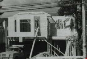
- Scope and Content
- Photograph of new houses being constructed on the 33 foot lots between 5496 Dominion Street and Douglas Road. Framing is complete and the houses' roofs and windows are installed.
- Repository
- City of Burnaby Archives
- Date
- 1982 (date of original), copied 2017
- Collection/Fonds
- Small family fonds
- Physical Description
- 1 photograph : col. copy print ; 10 cm x 15 cm
- Description Level
- Item
- Record No.
- 620-074
- Access Restriction
- No restrictions
- Reproduction Restriction
- No reproduction permitted
- Accession Number
- 2017-01
- Scope and Content
- Photograph of new houses being constructed on the 33 foot lots between 5496 Dominion Street and Douglas Road. Framing is complete and the houses' roofs and windows are installed.
- Media Type
- Photograph
- Notes
- Transcribed title
- Title transcribed from donor's notes
- Note in blue ink on verso of photograph reads: "P.16"
- Geographic Access
- Dominion Street
- Street Address
- 5496 Dominion Street
- Historic Neighbourhood
- Burnaby Lake (Historic Neighbourhood)
- Planning Study Area
- Ardingley-Sprott Area
Images

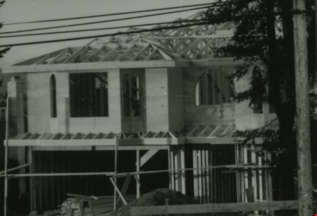
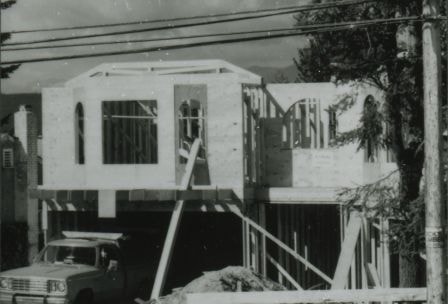
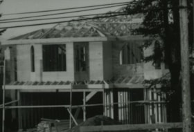
6742 Walker Avenue construction
https://search.heritageburnaby.ca/link/archivedescription37855
- Repository
- City of Burnaby Archives
- Date
- June 1987 (date of original), copied 1991
- Collection/Fonds
- Burnaby Historical Society fonds
- Description Level
- Item
- Physical Description
- 1 photograph : b&w ; 3.0 x 4.4 cm print on contact sheet 20.6 x 26.7 cm
- Scope and Content
- Photograph of the construction of a house at 6742 Walker Avenue.
- Repository
- City of Burnaby Archives
- Date
- June 1987 (date of original), copied 1991
- Collection/Fonds
- Burnaby Historical Society fonds
- Subseries
- Burnaby Image Bank subseries
- Physical Description
- 1 photograph : b&w ; 3.0 x 4.4 cm print on contact sheet 20.6 x 26.7 cm
- Description Level
- Item
- Record No.
- 370-443
- Access Restriction
- No restrictions
- Reproduction Restriction
- No restrictions
- Accession Number
- BHS1999-03
- Scope and Content
- Photograph of the construction of a house at 6742 Walker Avenue.
- Media Type
- Photograph
- Notes
- Title based on contents of photograph
- 1 b&w copy negative accompanying
- Negative has a pink cast
- Copied from col. photograph
- Geographic Access
- Walker Avenue
- Street Address
- 6742 Walker Avenue
- Historic Neighbourhood
- Edmonds (Historic Neighbourhood)
- Planning Study Area
- Richmond Park Area
Images
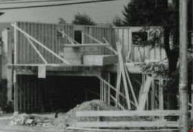
6742 Walker Avenue construction
https://search.heritageburnaby.ca/link/archivedescription37856
- Repository
- City of Burnaby Archives
- Date
- June 1987 (date of original), copied 1991
- Collection/Fonds
- Burnaby Historical Society fonds
- Description Level
- Item
- Physical Description
- 1 photograph : b&w ; 3.1 x 4.4 cm print on contact sheet 20.4 x 26.7 cm
- Scope and Content
- Photograph of the construction of a house at 6742 Walker Avenue.
- Repository
- City of Burnaby Archives
- Date
- June 1987 (date of original), copied 1991
- Collection/Fonds
- Burnaby Historical Society fonds
- Subseries
- Burnaby Image Bank subseries
- Physical Description
- 1 photograph : b&w ; 3.1 x 4.4 cm print on contact sheet 20.4 x 26.7 cm
- Description Level
- Item
- Record No.
- 370-444
- Access Restriction
- No restrictions
- Reproduction Restriction
- No restrictions
- Accession Number
- BHS1999-03
- Scope and Content
- Photograph of the construction of a house at 6742 Walker Avenue.
- Media Type
- Photograph
- Notes
- Title based on contents of photograph
- 1 b&w copy negative accompanying
- Negative has a pink cast
- Copied from col. photograph
- Geographic Access
- Walker Avenue
- Street Address
- 6742 Walker Avenue
- Historic Neighbourhood
- Edmonds (Historic Neighbourhood)
- Planning Study Area
- Richmond Park Area
Images
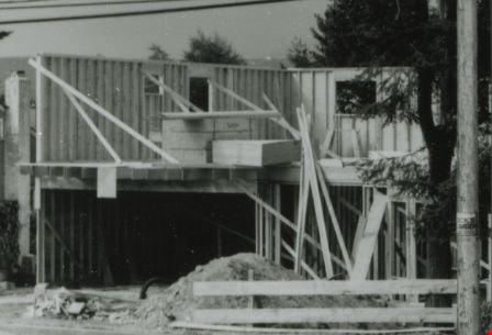
6742 Walker Avenue construction
https://search.heritageburnaby.ca/link/archivedescription37857
- Repository
- City of Burnaby Archives
- Date
- June 1987 (date of original), copied 1991
- Collection/Fonds
- Burnaby Historical Society fonds
- Description Level
- Item
- Physical Description
- 1 photograph : b&w ; 3.1 x 4.4 cm print on contact sheet 20.4 x 26.7 cm
- Scope and Content
- Photograph of the construction of a house at 6742 Walker Avenue.
- Repository
- City of Burnaby Archives
- Date
- June 1987 (date of original), copied 1991
- Collection/Fonds
- Burnaby Historical Society fonds
- Subseries
- Burnaby Image Bank subseries
- Physical Description
- 1 photograph : b&w ; 3.1 x 4.4 cm print on contact sheet 20.4 x 26.7 cm
- Description Level
- Item
- Record No.
- 370-445
- Access Restriction
- No restrictions
- Reproduction Restriction
- No restrictions
- Accession Number
- BHS1999-03
- Scope and Content
- Photograph of the construction of a house at 6742 Walker Avenue.
- Media Type
- Photograph
- Notes
- Title based on contents of photograph
- 1 b&w copy negative accompanying
- Negative has a pink cast
- Copied from col. photograph
- Geographic Access
- Walker Avenue
- Street Address
- 6742 Walker Avenue
- Historic Neighbourhood
- Edmonds (Historic Neighbourhood)
- Planning Study Area
- Richmond Park Area
Images