Narrow Results By
Decade
- 2020s 72
- 2010s 174
- 2000s 86
- 1990s 75
- 1980s 138
- 1970s 391
- 1960s 440
- 1950s 160
- 1940s 102
- 1930s 111
- 1920s 284
- 1910s 383
- 1900s
- 1890s 31
- 1880s 6
- 1870s 4
- 1860s 7
- 1850s 4
- 1840s 1
- 1830s 1
- 1820s 1
- 1810s 1
- 1800s 1
- 1790s 1
- 1780s 1
- 1770s 1
- 1760s 1
- 1750s
- 1740s 1
- 1730s 1
- 1720s 1
- 1710s 1
- 1700s 1
- 1690s 1
- 1680s 1
- 1670s 1
- 1660s 1
- 1650s 1
- 1640s 1
- 1630s 1
- 1620s 1
- 1610s 1
- 1600s 1
- 1520s 1
Subject
- Advertising Medium 1
- Agriculture - Fruit and Berries 1
- Animals - Horses 1
- Buildings - Commercial 1
- Buildings - Commercial - Grocery Stores 1
- Buildings - Industrial 1
- Buildings - Industrial - Factories 5
- Buildings - Industrial - Saw Mills 2
- Buildings - Religious - Churches 7
- Clothing 1
- Clothing - Uniforms 1
- Construction - Road Construction 1
Creator
- Burnaby Village Museum 2
- Burnett, Geoffrey K. 1
- Burnett & McGugan, Engineers and Surveyors 7
- City of Burnaby 1
- Draper, William Nelson 1
- Edison, Thomas F. 1
- Frame, Norvie Leggett 1
- Garden, Hermon & Burwell 1
- Gauvreau, Narcisse B. 1
- Government of Canada - Department of Mines - Geological Survey Branch 1
- Gunsaulus, Frank W. (Frank Wakeley), 1856-1921 2
- Hawkins, N. (Nehemiah), 1833-1928 1
Person / Organization
- All Saints Anglican Church 1
- Bradbury, Dr. Bettina 2
- British Columbia Electric Railway Company 1
- Broadview Presbyterian Church 1
- Brown, Charles B. "Charlie" 1
- Canadian Pacific Railway Company 2
- Dundonald United Church 1
- Easthope and Sons 1
- Easthope Brothers 1
- Exworthy, William Albert "Bert" 1
- Gilley Brothers Logging Company 3
- Great Northern Railway 2

Murdock and Lillian McMurray interview November 17, 1975 - Track 5
https://search.heritageburnaby.ca/link/oralhistory247
- Repository
- City of Burnaby Archives
- Date Range
- 1904-1975
- Length
- 0:09:26
- Summary
- This portion of the recording pertains to Murdock McMurray's memories of his first team of horses. Lillian (Wray) McMurray and her husband discuss their son Bob McMurray's volunteerism and professional activities.
- Repository
- City of Burnaby Archives
- Summary
- This portion of the recording pertains to Murdock McMurray's memories of his first team of horses. Lillian (Wray) McMurray and her husband discuss their son Bob McMurray's volunteerism and professional activities.
- Date Range
- 1904-1975
- Photo Info
- Emerson Doran (left) and Murdoch McMurray, 1917. Item no. 229-004
- Length
- 0:09:26
- Names
- McMurray, Bob
- Subjects
- Transportation - Sleighs
- Animals - Horses
- Interviewer
- McGeachie, Doreen “Pixie”
- Interview Date
- November 17, 1975
- Scope and Content
- Recording is of an interview with Murdock McMurray and his wife Lillian (Wray) McMurray conducted by Pixie McGeachie on November 17, 1975. Major themes discussed are: Burnaby's development, the Wray Shoe store and Murdock McMurray's cordwood delivery business.
- Biographical Notes
- Murdock McMurray was born in Vancouver in 1892 to Wilhelmina May and Robert William McMurray. Other children in the family included older siblings John “Jack” and Margaret Lillian, younger siblings Minnie May born May 4, 1895 and Hampton born June 8, 1902. Murdock’s father Robert worked for the Canadian Pacific Railway (CPR) but retired shortly after moving his family to Burnaby in 1906. He bought six acres of land of what had been previously the Gilley Ranch, the base of operations for Gilley Bros. Ltd. at 2519 Windsor Street (later renumbered and renamed to the 6400 block Imperial Street). Murdock McMurray quit school early to apprentice as a printer. By sixteen he had left the trade and gone into partnership with his older brother Jack. With a team of horses, harness and a wagon, the brothers helped to macadamize roads, haul building supplies for new homes, deliver cord wood for heating, clear land and excavate basements. When Jack McMurray set off to serve overseas during World War I as a driver in the engineer corps, Murdock bought his team of horses and continued working, mainly in the Deer Lake district. In 1916 Murdoch McMurray partnered with Emerson Doran, nephew of the owner of Doran's Mill to buy Edmonds Coal and Wood fuel yard. As everything was geared towards the war effort, Murdock and Emerson soon ran out of work and had to sell the business. Murdock sold off his horses and equipment and went to work at the ship yard on Pitt River. By 1919 Jack McMurray had returned home from overseas and was working as a fireman at the Shull Lumber and Shingle Mill on the Fraser River. In 1921, he and Murdock teamed up with Emerson Doran and repurchased the Edmonds Coal and Wood fuel yard which they ran together until 1947. Murdock McMurray married Lillian Wray on September 17, 1925. Lillian was the daughter of Mr. and Mrs. Edward Wray, who came to settle in the Jubilee area of Burnaby in 1919. The family lived on Dow Road and Edward Wray operated Jubilee Shoe Store and Post Office. He was known throughout the district as "Wray - The Shoe Man." Mrs. Wray died in 1957 at the age of eight-six and Edward Wray died January 14, 1967 at age of ninety-three. Murdock and Lillian lived at Inverness Street (now Arcola) and raised three children together, Bob, Jack and Bessie. Murdock McMurray died in New Westminster on April 28, 1985 at the age of ninety-two. Lillian Ethel (Wray) McMurray died in Burnaby on February 28, 1986 at the age of eighty-seven.
- Total Tracks
- 7
- Total Length
- 0:58:55
- Interviewee Name
- McMurray, Lillian Wray
- McMurray, Murdoch
- Interviewer Bio
- Doreen "Pixie" (Johnson) McGeachie was a resident of Burnaby for over sixty years. Pixie married John Aloysius "Jack" McGeachie and raised their children Kathi (Dunlop) and David McGeachie in the house the couple built themselves in 1947. Pixie served as the editor for the Burnaby Examiner newspaper and wrote a column entitled "Burnaby History" for The News. In 1974 she authored her first book titled "Bygones of Burnaby" which was one of the first to develop anecdotal stories about pioneer life in Burnaby. She authored "Burnaby - A Proud Century" in 1992 and in 2002 she wrote a biography of the city's namesake in the book "Land of Promise: Robert Burnaby's letters from Colonial B.C." She also contributed many hours of volunteering; helping to establish Burnaby's first museum Heritage Village in 1971, serving as President of the Burnaby Historical Society from 1991-1993. She served a six year term on Burnaby's Heritage Commission leading the charge to preserve many historic sites throughout the city, and during her twenty years as the Community Archives volunteer archivist for the historical society, she succeeded in gathering thousands of rare and valuable historic photographs and documents which now forms the core of the photograph collection on the Heritage Burnaby website (as these items were donated by the Society to the City Archives in 2007). The City of Burnaby awarded Pixie McGeachie the Kushiro Cup as Citizen of the year in 2002. In 2006 she received a Heritage BC project award for leading the Friends of Interurban 1223 project, and in 2008 Heritage BC recognised her again by presenting her with the Ruby Nobb Award. John Aloysius "Jack" McGeachie died October 12, 1981 at the age of sixty-seven. Doreen "Pixie" (Johnson) McGeachie died August 14, 2010 at the age of eighty-nine. On 24 September, 2011, the City of Burnaby dedicated the reading at the City Archives in honour of Pixie and formally named it the Pixie McGeachie Reading Room in recognition of her years of service to the community.
- Collection/Fonds
- Burnaby Historical Society fonds
- Subseries
- Oral history subseries
- Media Type
- Sound Recording
- Web Notes
- Interview was digitized in 2010 allowing it to be accessible on Heritage Burnaby. The digitization project was initiated by the Community Heritage Commission with support from City of Burnaby Council and the BC History Digitization Program of the Irving K. Barber Learning Centre, University of British Columbia. It was recognized by the Heritage Society of BC with an award in 2012.
Images

Audio Tracks
Track five of recording of interview with Lillian and Murdock McMurray
Track five of recording of interview with Lillian and Murdock McMurray
https://search.heritageburnaby.ca/media/hpo/_Data/_Archives_Oral_Histories/_Unrestricted/MSS137-010/MSS137-010_Track_5.mp3Public Works Engineer promise to support the Councils request for a supplementary grant towards the completion of the Vancouver Rd. improvement
https://search.heritageburnaby.ca/link/councilreport79160
- Repository
- City of Burnaby Archives
- Report ID
- 89158
- Meeting Date
- 16-Mar-1901
- Format
- Council - Mayor/Councillor/Staff Report
- Collection/Fonds
- City Council and Office of the City Clerk fonds
- Repository
- City of Burnaby Archives
- Report ID
- 89158
- Meeting Date
- 16-Mar-1901
- Format
- Council - Mayor/Councillor/Staff Report
- Collection/Fonds
- City Council and Office of the City Clerk fonds
Documents
Quantity surveying : for the use of surveyors, architects, engineers and builders
https://search.heritageburnaby.ca/link/museumlibrary2609
- Repository
- Burnaby Village Museum
- Edition
- 5th ed., rev. and enl.
- Publication Date
- 1904
- Call Number
- 692 LEA
- Repository
- Burnaby Village Museum
- Collection
- Special Collection
- Material Type
- Book
- Accession Code
- HV974.23.1
- Call Number
- 692 LEA
- Edition
- 5th ed., rev. and enl.
- Place of Publication
- London
- Publisher
- E. & F. N. Spon, Ltd.
- Publication Date
- 1904
- Physical Description
- vi-vii; 936 p. : ill. ; 23 cm.
- Library Subject (LOC)
- Building--Estimates
Report of Engineer re Douglas Road
https://search.heritageburnaby.ca/link/councilreport75742
- Repository
- City of Burnaby Archives
- Report ID
- 80992
- Meeting Date
- 10-Dec-1909
- Format
- Council - Mayor/Councillor/Staff Report
- Collection/Fonds
- City Council and Office of the City Clerk fonds
- Repository
- City of Burnaby Archives
- Report ID
- 80992
- Meeting Date
- 10-Dec-1909
- Format
- Council - Mayor/Councillor/Staff Report
- Collection/Fonds
- City Council and Office of the City Clerk fonds
Documents
![St. Albans the Martyr, [ca.1910] thumbnail](/media/hpo/_Data/_BVM_Cartographic_Material/2003/2003_0083_0048_001.jpg?width=280)
St. Albans the Martyr
https://search.heritageburnaby.ca/link/museumdescription11926
- Repository
- Burnaby Village Museum
- Date
- [ca.1910]
- Collection/Fonds
- Ronald G. Scobbie collection
- Description Level
- Item
- Physical Description
- 1 plan : black ink and watercol. on paper ; 30.45 x 30.5 cm
- Scope and Content
- Item consists of building insurance plan of "St. Albans the Martyr / Lots 45 & 46 North Part DL 28 / GP1 N.W.D." Edmonds Street is to the north, Douglas Road to the west and 19th Avenue to the south.
- Repository
- Burnaby Village Museum
- Collection/Fonds
- Ronald G. Scobbie collection
- Description Level
- Item
- Physical Description
- 1 plan : black ink and watercol. on paper ; 30.45 x 30.5 cm
- Material Details
- Scale 1 inch = 40 feet
- Scope and Content
- Item consists of building insurance plan of "St. Albans the Martyr / Lots 45 & 46 North Part DL 28 / GP1 N.W.D." Edmonds Street is to the north, Douglas Road to the west and 19th Avenue to the south.
- Subjects
- Buildings - Religious - Churches
- Accession Code
- BV003.83.48
- Access Restriction
- No restrictions
- Reproduction Restriction
- No known restrictions
- Date
- [ca.1910]
- Media Type
- Cartographic Material
- Scan Resolution
- 600
- Scan Date
- 15-Jan-2021
- Scale
- 100
- Notes
- Transcribed title
- Note in pencil on verso reads: "St. Albans the Martyr / Lots 45 & 46 North Part DL 28 / 1" = 40' "
- Note in balck in on verso reads: "3704"
Images
![St. Albans the Martyr, [ca.1910] thumbnail](/media/hpo/_Data/_BVM_Cartographic_Material/2003/2003_0083_0048_001.jpg)
![St. Helen's Church, [ca.1910] thumbnail](/media/hpo/_Data/_BVM_Cartographic_Material/2003/2003_0083_0051_001.jpg?width=280)
St. Helen's Church
https://search.heritageburnaby.ca/link/museumdescription11929
- Repository
- Burnaby Village Museum
- Date
- [ca.1910]
- Collection/Fonds
- Ronald G. Scobbie collection
- Description Level
- Item
- Physical Description
- 1 plan : black ink and watercol. on paper ; 30.45 x 30.5 cm
- Scope and Content
- Item consists of building insurance plan of "St. Helen's Church / Lots 11 & 12 BK 7 DL 186 / GP1 N.W.D." . Ingleton Ave is identified to the east and Pandora St. to the south.
- Repository
- Burnaby Village Museum
- Collection/Fonds
- Ronald G. Scobbie collection
- Description Level
- Item
- Physical Description
- 1 plan : black ink and watercol. on paper ; 30.45 x 30.5 cm
- Material Details
- Scale 1 inch = 20 feet
- Scope and Content
- Item consists of building insurance plan of "St. Helen's Church / Lots 11 & 12 BK 7 DL 186 / GP1 N.W.D." . Ingleton Ave is identified to the east and Pandora St. to the south.
- Subjects
- Buildings - Religious - Churches
- Accession Code
- BV003.83.51
- Access Restriction
- No restrictions
- Reproduction Restriction
- No known restrictions
- Date
- [ca.1910]
- Media Type
- Cartographic Material
- Scan Resolution
- 600
- Scan Date
- 15-Jan-2021
- Scale
- 100
- Notes
- Transcribed title
- Note in pencil on verso reads: ""St. Helen's Church / Lots 11 & 12 BK 7 DL 186 / 1" = 20' "
- Note in balck in on verso reads: "3704"
Images
![St. Helen's Church, [ca.1910] thumbnail](/media/hpo/_Data/_BVM_Cartographic_Material/2003/2003_0083_0051_001.jpg)
![St. John the Divine, [ca.1910] thumbnail](/media/hpo/_Data/_BVM_Cartographic_Material/2003/2003_0083_0044_001.jpg?width=280)
St. John the Divine
https://search.heritageburnaby.ca/link/museumdescription11922
- Repository
- Burnaby Village Museum
- Date
- [ca.1910]
- Collection/Fonds
- Ronald G. Scobbie collection
- Description Level
- Item
- Physical Description
- 1 plan : black ink and watercol. on paper ; 30.45 x 30.5 cm
- Scope and Content
- Item consists of building insurance plan of "St. John the Divine / Lot "A" BK. 49 DL 35 GP1 N.W.D.". Kingsway is identified to the south of building.
- Repository
- Burnaby Village Museum
- Collection/Fonds
- Ronald G. Scobbie collection
- Description Level
- Item
- Physical Description
- 1 plan : black ink and watercol. on paper ; 30.45 x 30.5 cm
- Material Details
- Scale 1 inch = 20 feet
- Scope and Content
- Item consists of building insurance plan of "St. John the Divine / Lot "A" BK. 49 DL 35 GP1 N.W.D.". Kingsway is identified to the south of building.
- Subjects
- Buildings - Religious - Churches
- Accession Code
- BV003.83.44
- Access Restriction
- No restrictions
- Reproduction Restriction
- No known restrictions
- Date
- [ca.1910]
- Media Type
- Cartographic Material
- Scan Resolution
- 600
- Scan Date
- 15-Jan-2021
- Scale
- 100
- Notes
- Transcribed title
- Note in pencil on verso reads: "St. John the Divine / Lot "A" BK. 49 DL 35 / 1"=20' "
- Note in balck in on verso reads: "3704"
Images
![St. John the Divine, [ca.1910] thumbnail](/media/hpo/_Data/_BVM_Cartographic_Material/2003/2003_0083_0044_001.jpg)

Subdivision plans in New Westminster District Group 1 – Burnaby, Vancouver and map - Canada Department of Mines
https://search.heritageburnaby.ca/link/museumdescription6994
- Repository
- Burnaby Village Museum
- Date
- 1890-1909
- Collection/Fonds
- Burnaby Village Museum Map collection
- Description Level
- File
- Physical Description
- 1 plan : graphite on paper + 2 plans : black ink on paper + 1 map : col. on paper mounted on 2 sides of cardboard 76 x 102 cm
- Scope and Content
- Item consists of a large board with one New Westminster District subdivision plan mounted on one side and two New Westminster District subdivision plans and one colour map mounted on the other side. Side A: 1. "Plan / of Subdivision of / Blocks 2, 3, 4, 5, 6 / Lot 77 / Group 1 / New Westminster D…
- Repository
- Burnaby Village Museum
- Collection/Fonds
- Burnaby Village Museum Map collection
- Description Level
- File
- Physical Description
- 1 plan : graphite on paper + 2 plans : black ink on paper + 1 map : col. on paper mounted on 2 sides of cardboard 76 x 102 cm
- Material Details
- Scales 1:720 and 1:1200 and 1:.00001578
- Scope and Content
- Item consists of a large board with one New Westminster District subdivision plan mounted on one side and two New Westminster District subdivision plans and one colour map mounted on the other side. Side A: 1. "Plan / of Subdivision of / Blocks 2, 3, 4, 5, 6 / Lot 77 / Group 1 / New Westminster District / BC. / Scale 100 feet = 1 inch", "Deposited 8th day / of April 1890 / Mowileg [sic] / Dist. Regt". Plan is drawn in graphite with annotations: "AB_Parts_lettered_are_lots_in / the_different_subdivisions" / "Owners: / James E. Hall / P.S.Cabilan [sic] by his attorney Joseph Hall / Joseph Hall / Eliza J. Shannon / John Harrison"; "This plan is correct and is prepared under the / provisions of the Land Registry Act" ; signed by: "Gordon Herman & Burwell / Dominion & Provincial Land Surveryors / Vancouver March 19th/90" . Plan is initialed by: "RB" [sic] (in blue pencil crayon) and measures: 99.5 x 65 cm (Geographic location: Burnaby) Side B: 1. Map titled "Canada / Department of Mines / Geological Survey Branch" / "Hon.W Templeton, Minister / A.P. Low, Deputy Minister / R.W. Brock, Acting Director", Vol. XXXI, Plate I / Compiled under the direction of / James White, F.R.G.S. Geographer /Dep. of Interior". Note above map reads: "To illustrate Mr. James Barrowman's report as Delegate at the Excursion - meeting of the Canadian Mining Institute", "The instiitution of Mining Engineers / Transactions 1908 - 1909", "The Mining Institute of Scotland / Transactions 1908-1909". Map identifies minerals and includes a Legend and Scale: 100 miles = 1 inch 2. "Plan / of Subdivision of / Lot 4 / of Subdivision of / Lot 87. Gr. 1 / New Westminster District / Scale 60' = 1in." Plan is initialed by: "RB" [sic] along with a note "also Board / 48" (in blue pencil crayon) (Geographic location: Burnaby) 3. Plan of "Lot 335 / G. 1" west of Boundary Road and north of River Road - Vancouver. (Geographic location: Vancouver)
- Publisher
- The Mining Institute of Scotland
- Geographic Access
- Vancouver
- Accession Code
- HV977.93.25
- Access Restriction
- No restrictions
- Reproduction Restriction
- No known restrictions
- Date
- 1890-1909
- Media Type
- Cartographic Material
- Scan Resolution
- 300
- Scale
- 72
- Notes
- Title based on contents of file
- Scale is measured in feet and miles.
- The term "Lot" often refers to "District Lot"
Images


![Survey and Subdivision plans in New Westminster District Group 1 & Group 2 - Burnaby, Port Moody, Coquitlam, Mission and Map of Port Simpson Harbour, [190-] thumbnail](/media/hpo/_Data/_BVM_Cartographic_Material/1977/1977_0093_0111_001.jpg?width=280)
Survey and Subdivision plans in New Westminster District Group 1 & Group 2 - Burnaby, Port Moody, Coquitlam, Mission and Map of Port Simpson Harbour
https://search.heritageburnaby.ca/link/museumdescription7080
- Repository
- Burnaby Village Museum
- Date
- [190-]
- Collection/Fonds
- Burnaby Village Museum Map collection
- Description Level
- File
- Physical Description
- 9 plans : 3 plans : blueprint ink on paper + 4 plans : black ink and graphite on linen + 2 plans : graphite on paper mounted on 2 sides of cardboard 76 x 102 cm
- Scope and Content
- File consists of a large board with five plans in New Westminster District, Group 1 mounted on one side and three plans in New Westminster District, Group 1 and a map of Port Simpson Harbour mounted on the other side. Side A: 1. Plan: blueprint on paper ; 30 x 20 cm. Title reads: "Plan of / Subdi…
- Repository
- Burnaby Village Museum
- Collection/Fonds
- Burnaby Village Museum Map collection
- Description Level
- File
- Physical Description
- 9 plans : 3 plans : blueprint ink on paper + 4 plans : black ink and graphite on linen + 2 plans : graphite on paper mounted on 2 sides of cardboard 76 x 102 cm
- Material Details
- Scales vary (One chain equals 792 inches)
- Indexed number on tape on edge of board reads "111"
- Scope and Content
- File consists of a large board with five plans in New Westminster District, Group 1 mounted on one side and three plans in New Westminster District, Group 1 and a map of Port Simpson Harbour mounted on the other side. Side A: 1. Plan: blueprint on paper ; 30 x 20 cm. Title reads: "Plan of / Subdivision of Part of D.L.172.GR.I.N.W.D." Scale: 200 feet = 1inch. dated, Feb.22, 1908, signed by land surveyor "Noel Humphreys" (Geographic location: District Lot 172, Burnaby) 2. Plan : graphite and blue crayon on paper ; 21.5 x 22 cm. Title in blue crayon reads: "N.E.1/4 & NW 1/4 Sec.25 / Tp 18". Scale: 10 chains=1 inch (Geographic location: Mission) 3. Plan : graphite on paper ; 31.5 x 16 cm. Title in blue crayon reads: "Lot 350_ Gr.1" with initials "RB". Scale : 3 chains = 1 inch. (Geographic location: Port Moody) 4. Plan ; graphite on linen ; 40 x 54 cm. Title in blue crayon reads: "Lot 190_Gr.1" with initials "RB". Plan covers area in Lot 190 including streets identified as; McInness Street, First Street, Second Street, Third Street, Fourth Street running through District Lot. (Geographic location: Port Moody) 5. Plan: blueprint on paper ; 50.5 x 57.5 cm. Title reads: "Plan of / T.F. Sinclair's Quarry Site. / SituateOnPittRiver.Sec.122T.P.40. / East of Coast Mer." Scale: 5 chains = 1inch. dated June 30 1908 [sic] Plan covers site of T.F. Sinclair's quarry in Section 22 of Township 40 on the shore of Pitt River. (Geographic location: Coquitlam ) Side B: 1. Map : blueprint on paper ; 50 x 38 cm. Scale: 40 chains - 1 inch. Title reads: "Map of Land on / Port Simpson Harbor". Scale : 40 chains = 1 inch Map covers subdivided land on the North Coast of British Columbia on the Tsimpsean Pennisula bordered by water identified as "Work Channel" to the west, "Port Simpson Harbour" to the east and land identified as "Indian Reserve" [Lax Kw'alaams] to the south. Names of property owners are identified in subdivided sections and area of land along the shore of "Work Channel" is identified as "Goverment Reserve". Blueprint includes inset "Key Map" with location of Port Simpson Harbour and Tsimpean Pennisula on the North Coast of British Columbia. 2. Plan : graphite on linen ; 24.5 x 46 cm. Title reads: "Portion of Lot 470 / Group 1" Scale : 2 chains = 1 inch. Plan covers a subdivided portion of District Lot 470, New Westminster District, Group 1 with streets identified as; "Pleasant Street", "Metta Street" and "Clarence Street". (Geographic location: Port Moody) 3. Plan : black ink on linen ; 40 x 30.5 cm. Title reads: "Plan / of / A Portion of the Foreshore / of / Lot 201 GR.2 / N.W.D. / Showing / Mill-Site". Scale : 100 feet = 1 inch. Plan is stamped in red ink: "Albert J. Hill, M.A., / Civil Engineer / And / Provincial Land Surveyor, / New Westminster, / B.C.". Survey notes in black ink read: "Surveyed Oct 9th 1908 for Messrs. / Roe & Abernathy and plan (duplicate / of this one) sent Oct. 8th / G.K. Burnett". (Geographic location : Port Moody) 4. Plan : black and red ink on line ; 63 x 29.5 cm. Title reads: "Port Moody / Butchard's Property". Scale : 200 feet = 1 inch. Plan covers subdivided lot into 16 parcels numbered I to XVI along the north shore of Burrard Inlet in Port Moody. Streets are identified as; George Street, Bruce Street, Norval Street, Nora Street, Elm Street, Pine Street, Orr Street and Orchard Street. Roads are identified as; West Road and East Road. (Geographic location : Port Moody)
- Creator
- Hill, Albert James
- Accession Code
- HV977.93.111
- Access Restriction
- No restrictions
- Reproduction Restriction
- No known restrictions
- Date
- [190-]
- Media Type
- Cartographic Material
- Scan Resolution
- 600
- Scan Date
- 2023-06-26
- Notes
- Title based on contents of file
Zoomable Images
![Survey and Subdivision plans in New Westminster District Group 1 & Group 2 - Burnaby, Port Moody, Coquitlam, Mission and Map of Port Simpson Harbour, [190-] thumbnail](/media/hpo/_Data/_BVM_Cartographic_Material/1977/1977_0093_0111_003_seadragon/1977_0093_0111_003.jpg?w=280)
Survey and Subdivision plans in New Westminster District Group 1 & Group 2 - Burnaby, Port Moody, Coquitlam, Mission and Map of Port Simpson Harbour, [190-]
Zoom into Image
![Survey and Subdivision plans in New Westminster District Group 2 - Surrey and Map of Surrey Municipality, [190-] thumbnail](/media/hpo/_Data/_BVM_Cartographic_Material/1977/1977_0093_0094_003.jpg?width=280)
Survey and Subdivision plans in New Westminster District Group 2 - Surrey and Map of Surrey Municipality
https://search.heritageburnaby.ca/link/museumdescription7063
- Repository
- Burnaby Village Museum
- Date
- [190-]
- Collection/Fonds
- Burnaby Village Museum Map collection
- Description Level
- File
- Physical Description
- 5 plans : blueprints on paper ; various sizes mounted on 2 sides of cardboard 76 x 102 cm
- Scope and Content
- File consists of a large board with two plans in New Westminster District (Group 2) mounted on one side and three plans in New Westminster District (Group 2) mounted on the other side. Side A: 1. Plan : blueprint on paper ; 75.5 x 64.5 cm. Title reads: "South Westminster / Plan/ of Subdivision of…
- Repository
- Burnaby Village Museum
- Collection/Fonds
- Burnaby Village Museum Map collection
- Description Level
- File
- Physical Description
- 5 plans : blueprints on paper ; various sizes mounted on 2 sides of cardboard 76 x 102 cm
- Material Details
- Scales vary (One chain equals 792 inches)
- Indexed number on tape on edge of board reads 94"
- Scope and Content
- File consists of a large board with two plans in New Westminster District (Group 2) mounted on one side and three plans in New Westminster District (Group 2) mounted on the other side. Side A: 1. Plan : blueprint on paper ; 75.5 x 64.5 cm. Title reads: "South Westminster / Plan/ of Subdivision of / Lot 440, G2, E1/2Sec36, NE1/4Sec25, N1/2ofSE1/4Sec25, T4.NW1/4S31,T2.". Subdivision plan covers subdivided property in Lot 440 and Section 36, Section 25 in New Westminster, Group 2, Township 4 (Delta) and Section 31 in Township 2 (Surrey). Includes inset map noting property in "South Westminster". Map is bordered by Burrard Inlet to the north and Mud Bay to the south. (Geographic locations: North Delta and Surrey) 2. Plan : blueprint on paper ; 22.5 x 59.5 cm. Title reads: "Plan / Shewing part of / Section 10 Block 5 North R.I.W. / New Westminster District / Lying North of B.C.S.Railway". Scale: 2 chains = 1 inch. Signed by A.S. Colton, District Land Surveyor. March 1, 1900. Plan covers property in Section 10, Block 5 North in New Westminster District, Group 2, along the south shore of the Fraser River with the Great Northern Railway running through. (Geographic location: Surrey) Side B: 1. Map : blueprint on paper ; 69 x 53 cm. Title reads: "Map / of / Surrey Municipality". Scale: 5 chains = 1 inch. Creator and surveyor of map is identified as "Albert J. Hill, M.A., Civil Engineer / And / Provincial Land Surveyor, / New Westminster, / B.C.". Map identifies property divisions including lots with names of property owners, Sections, Townships, Wards, waterways, major roads, railways and the Semiahmoo Indian Reserve on the shore of "Semiahmoo Bay" and an indian reserve (I.R.) located in Lot 1 along the south shore of the Fraser River. 2. Plan : blueprint on paper ; 21 x 40.5 cm. Title reads: "Plan / of / Sudivision of / Section 32, / Block 5 North Range 1 West, / District of New Westminster, B.C.". Scale: 4 chains = 1 inch. Sudivision plan is signed by Albert J. Hill, B.C. Land Surveyor. Plan covers Section 32, subdivided into 28 parcels. Section 32 is bordered by Section 29 (north), Section 33, Johnston Road (east), Section 34, Township 2, Town Line Road (south) and Section 31 (west). (Geographic location: Surrey) 3. Plan : blueprint on paper ; 49.5 x 37 cm. Title reads: "Traverse of the Waterline / in front of / Lots 3 and 4 Group 2 / N.W.D. / with G.N. Railway Rt of Way". Scale: 100 feet = 1 inch. Annotation on board below plan reads: "also see Boards 87 & 93 & 110". Location south of the Fraser River with old wharf identified and Great Northern Railway running east to west along the river. (Geographic location: Surrey)
- Names
- Great Northern Railway
- Accession Code
- HV977.93.94
- Access Restriction
- No restrictions
- Reproduction Restriction
- No known restrictions
- Date
- [190-]
- Media Type
- Cartographic Material
- Scan Resolution
- 600
- Scan Date
- 2023-06-26
- Notes
- Title based on contents of file
Zoomable Images
![Survey and Subdivision plans in New Westminster District Group 2 - Surrey and Map of Surrey Municipality, [190-] thumbnail](/media/hpo/_Data/_BVM_Cartographic_Material/1977/1977_0093_0094_003_seadragon/1977_0093_0094_003.jpg?w=280)
Survey and Subdivision plans in New Westminster District Group 2 - Surrey and Map of Surrey Municipality, [190-]
Zoom into Image
Traction Engine
https://search.heritageburnaby.ca/link/councilreport74611
- Repository
- City of Burnaby Archives
- Report ID
- 80550
- Meeting Date
- 16-Aug-1909
- Format
- Council - Mayor/Councillor/Staff Report
- Collection/Fonds
- City Council and Office of the City Clerk fonds
- Repository
- City of Burnaby Archives
- Report ID
- 80550
- Meeting Date
- 16-Aug-1909
- Format
- Council - Mayor/Councillor/Staff Report
- Collection/Fonds
- City Council and Office of the City Clerk fonds
Documents
Westminster Branch employees
https://search.heritageburnaby.ca/link/archivedescription36546
- Repository
- City of Burnaby Archives
- Date
- 1905
- Collection/Fonds
- Burnaby Historical Society fonds
- Description Level
- Item
- Physical Description
- 1 photograph : sepia composite ; 19 x 24 cm on board 27 x 32.5 cm
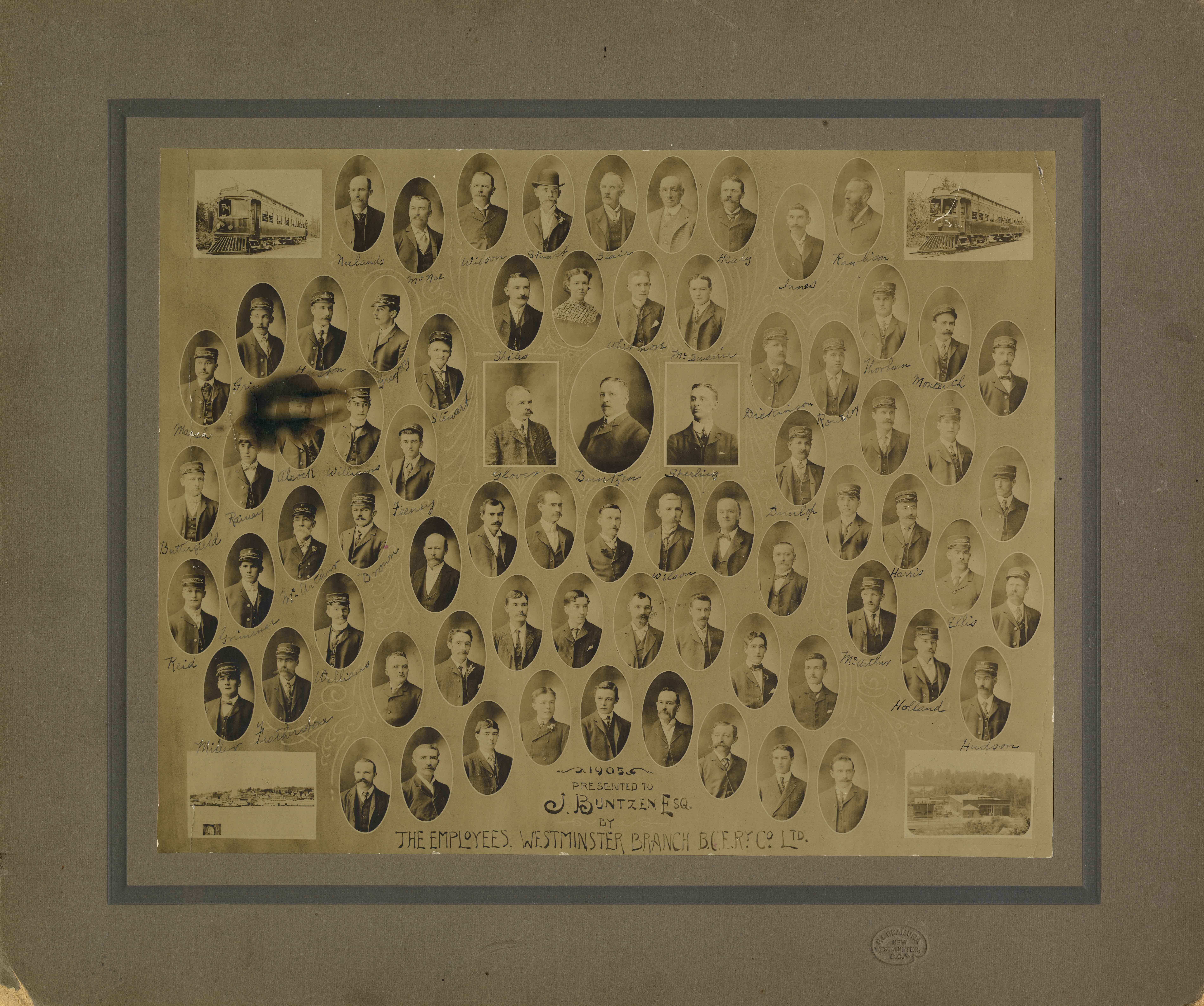
- Scope and Content
- Composite photograph of the employees of the Westminster Branch of the British Columbia Electric Railway Company. A name has been written in pen under many of the photographs: starting at the top left; Neelands, McNel, Wilson, Stuart, Blair, unidentified, Healy, Innes, Rawlison. One row down, five …
- Repository
- City of Burnaby Archives
- Date
- 1905
- Collection/Fonds
- Burnaby Historical Society fonds
- Subseries
- John DeForest subseries
- Physical Description
- 1 photograph : sepia composite ; 19 x 24 cm on board 27 x 32.5 cm
- Description Level
- Item
- Record No.
- 293-007
- Access Restriction
- No restrictions
- Reproduction Restriction
- No known restrictions
- Accession Number
- BHS1992-30
- Scope and Content
- Composite photograph of the employees of the Westminster Branch of the British Columbia Electric Railway Company. A name has been written in pen under many of the photographs: starting at the top left; Neelands, McNel, Wilson, Stuart, Blair, unidentified, Healy, Innes, Rawlison. One row down, five together to the left are; Marsh, Grimmison, Huston, Gregory, Stewart. Four in the center are; Shiles, unidentified, Whitmore, McQuarrie. Five together to the right are; Dickinson, Routley, Thorburn, Monterth, unidentified. Second row down, five together on the left are; Butterfield, Rainey, Alcock, WIlliams, Feeney. Three together in the center are; Glover, Buntzen, Sperling. Four together on the right are; Dunlop and three unidentified.Three rows down, four together on the left are; Reid, Grimmer, McArthur, Brown. Center is unidentified except for Wilson, who is three from the right. Four together on the right are; unidentified, Harris, Ellis, unidentified. Four rows down, three together on the left are; Miller, Featherstone, Williams. The rest of the center are unidentified, and the last three on the right are; McAurthur, Holland, and Hudson. Also included in the composite are two photographs of electric railroad cars, one of the New Westminster shoreline and one of a train station.
- Subjects
- Occupations - Engineers
- Occupations - Railroad Conductors
- Transportation - Electric Railroads
- Media Type
- Photograph
- Photographer
- Okamura, P.L.
- Notes
- Title based on contents of photograph
- Note on recto of composite photograph reads: "~1905~/ PRESENTED TO / J. BUNTZEN ESQ./ BY / THE EMPLOYEES, WESTMINISTER BRANCH B.C.E.RY.CO.LTD."
- Photographer's stamp on recto of board reads: "P. L. OKAMURA NEW WESTMINISTER, B.C."
Images