Narrow Results By
Decade
- 2020s 152
- 2010s 212
- 2000s 242
- 1990s 654
- 1980s 612
- 1970s 1012
- 1960s
- 1950s 393
- 1940s 582
- 1930s 544
- 1920s 476
- 1910s 476
- 1900s 404
- 1890s 117
- 1880s
- 1870s 14
- 1860s 12
- 1850s 5
- 1840s 3
- 1830s 3
- 1820s 3
- 1810s 3
- 1800s 3
- 1790s 3
- 1780s 3
- 1770s 3
- 1760s 3
- 1750s 3
- 1740s
- 1730s 3
- 1720s 3
- 1710s 3
- 1700s 3
- 1690s 3
- 1680s 3
- 1670s 3
- 1660s 3
- 1650s 3
- 1640s 3
- 1630s 3
- 1620s 3
- 1610s 3
- 1600s 3
- 1520s 1
Subject
- Adornment - Jewelry 2
- Aerial Photographs 1
- Agriculture 2
- Agriculture - Dairy 1
- Agriculture - Farms 9
- Animals - Horses 1
- Arts - Drawings 1
- Building - Agricultural 2
- Buildings - Civic - Fire Halls 1
- Buildings - Commercial 1
- Buildings - Commercial - Department Stores 1
- Buildings - Commercial - Drive-in Theatres 1
![Staff Sergeant Brue, [between 1966 and 1969] (date of original) thumbnail](/media/hpo/_Data/_BVM_Images/2000/200100250075.jpg?width=280)
Staff Sergeant Brue
https://search.heritageburnaby.ca/link/museumdescription1600
- Repository
- Burnaby Village Museum
- Date
- [between 1966 and 1969] (date of original)
- Collection/Fonds
- Burnaby Village Museum Photograph collection
- Description Level
- Item
- Physical Description
- 1 photograph : col. photocopy ; 25 x 20 cm
- Scope and Content
- Photograph of Royal Canadian Mounted Police Staff Sergeant Theodore Olaf Brue in uniform. Five star badges have been stitched to his left sleeve (each star represents five years of service) and the small badge above his left pocket represents twenty years of service and good conduct.
- Repository
- Burnaby Village Museum
- Collection/Fonds
- Burnaby Village Museum Photograph collection
- Description Level
- Item
- Physical Description
- 1 photograph : col. photocopy ; 25 x 20 cm
- Material Details
- Photograph is a photocopy (on rag paper) of an original colour photograph
- Scope and Content
- Photograph of Royal Canadian Mounted Police Staff Sergeant Theodore Olaf Brue in uniform. Five star badges have been stitched to his left sleeve (each star represents five years of service) and the small badge above his left pocket represents twenty years of service and good conduct.
- Accession Code
- BV001.25.75
- Access Restriction
- Restricted access
- Reproduction Restriction
- May be restricted by third party rights
- Date
- [between 1966 and 1969] (date of original)
- Media Type
- Photograph
- Scan Resolution
- 600
- Scan Date
- 09-Jun-09
- Scale
- 100
- Notes
- Title based on contents of photograph
Images
![Staff Sergeant Brue, [between 1966 and 1969] (date of original) thumbnail](/media/hpo/_Data/_BVM_Images/2000/200100250075.jpg)
![Student cast of the Christmas concert at Douglas Road Elementary School, [1962-1963] thumbnail](/media/hpo/_Data/_BVM_Images/2007/2007_0026_0007_001.jpg?width=280)
Student cast of the Christmas concert at Douglas Road Elementary School
https://search.heritageburnaby.ca/link/museumdescription2826
- Repository
- Burnaby Village Museum
- Date
- [1962-1963]
- Collection/Fonds
- Burnaby Village Museum Photograph collection
- Description Level
- Item
- Scope and Content
- Wide angle photograph 25.3 cm wide X 10.5 cm high: Cast of "Alicia", student production, Christmas Concert, at Douglas Road Elementary School for the 1962 to 1963 school year. The photograph is taken on the school stage in the gym. Mr Jim Young, the school principal is standing on the far right. M…
- Repository
- Burnaby Village Museum
- Collection/Fonds
- Burnaby Village Museum Photograph collection
- Description Level
- Item
- Scope and Content
- Wide angle photograph 25.3 cm wide X 10.5 cm high: Cast of "Alicia", student production, Christmas Concert, at Douglas Road Elementary School for the 1962 to 1963 school year. The photograph is taken on the school stage in the gym. Mr Jim Young, the school principal is standing on the far right. Mr Frank Allder, the school vice-principal is standing on the far left. The teacher standing in front of Mr. Allder is Dorothy [Yamamotto] (nee Mayeda). The teacher standing next to Mr. Allder is Miss. Madsen. The teacher standing next to Mr. Young is Barbara Klier (nee Hasals). The teacher at the far right of the top row is Sharon Kelly.
- Accession Code
- BV007.26.7
- Access Restriction
- Restricted access
- Reproduction Restriction
- May be restricted by third party rights
- Date
- [1962-1963]
- Media Type
- Photograph
- Scan Resolution
- 300
- Scan Date
- 29-Nov-2018
- Scale
- 96
- Notes
- Originally housed in a photographic album
- "Mr. Allder" in pencil on verso
- Crease through center of photograph
Images
![Student cast of the Christmas concert at Douglas Road Elementary School, [1962-1963] thumbnail](/media/hpo/_Data/_BVM_Images/2007/2007_0026_0007_001.jpg)
![Subdivision plans in New Westminster District Group 1 – Burnaby
, [1882-1910] thumbnail](/media/hpo/_Data/_BVM_Cartographic_Material/1977/1977_0093_0013a_001.jpg?width=280)
Subdivision plans in New Westminster District Group 1 – Burnaby
https://search.heritageburnaby.ca/link/museumdescription6982
- Repository
- Burnaby Village Museum
- Date
- [1882-1910]
- Collection/Fonds
- Burnaby Village Museum Map collection
- Description Level
- File
- Physical Description
- 4 plans : blueprint on paper mounted on 2 sides of cardboard 76 x 102 cm
- Scope and Content
- Item consists of a large board of two New Westminster District Gp 1 - subdivision plans mounted on one side and two New Westminster District Gp 1 - subdivision plans mounted on the other side. Side A: 1. Blueprint "Plan / of the / Subdivision / of / Lot 98 / G.1, N.W.D. / Scale 4 chs = 1 in. / …
- Repository
- Burnaby Village Museum
- Collection/Fonds
- Burnaby Village Museum Map collection
- Description Level
- File
- Physical Description
- 4 plans : blueprint on paper mounted on 2 sides of cardboard 76 x 102 cm
- Material Details
- Scales [between 1:1584 and 1:3168]
- Index number on edge of board reads: "13"
- Scope and Content
- Item consists of a large board of two New Westminster District Gp 1 - subdivision plans mounted on one side and two New Westminster District Gp 1 - subdivision plans mounted on the other side. Side A: 1. Blueprint "Plan / of the / Subdivision / of / Lot 98 / G.1, N.W.D. / Scale 4 chs = 1 in. / Map No 573" (Geographic location: Burnaby) 2. Blueprint "Plan / of Subdivision of / Lot 157 / Gr.1, New. West. Dist. / Scale 3 chs = 1 in. / Map No. 612". (Geographic location: Burnaby) Side B: 1. Blueprint "Plan / of Subdivision / of a Portion of / Lot 90 / Group One / New Westminster Dist. / Scale 2 chs = 1 in. / Map No. 555". Plan is signed by "Jno Strathern [sic]_P.L.S."n (Geographic location: Burnaby) 2. Blueprint "Subdivision of Lot 31, Group 1. / New Westminster District / As Amended by Order of Court / 1st Sept. 1882 and Numbered 847 / Scale 4 chs = 1in. / Map No 80" (Geographic location: Burnaby)
- Creator
- Stathern, John
- Accession Code
- HV977.93.13
- Access Restriction
- No restrictions
- Reproduction Restriction
- No known restrictions
- Date
- [1882-1910]
- Media Type
- Cartographic Material
- Historic Neighbourhood
- Alta Vista (Historic Neighbourhood)
- Planning Study Area
- Richmond Park Area
- Lakeview-Mayfield Area
- Scan Resolution
- 300
- Scale
- 72
- Notes
- Title based on contents of file
- Scale is measured in chains. (One chain equals 792 inches)
- The term "Lot" can also refer to a "District Lot”
Images
![Subdivision plans in New Westminster District Group 1 – Burnaby
, [1882-1910] thumbnail](/media/hpo/_Data/_BVM_Cartographic_Material/1977/1977_0093_0013a_001.jpg)

![Survey and Subdivision plans in New Westminster District Group 1 – Burnaby
, [1861]-[1910] thumbnail](/media/hpo/_Data/_BVM_Cartographic_Material/1977/1977_0093_0019a_001.jpg?width=280)
Survey and Subdivision plans in New Westminster District Group 1 – Burnaby
https://search.heritageburnaby.ca/link/museumdescription6988
- Repository
- Burnaby Village Museum
- Date
- [1861]-[1910]
- Collection/Fonds
- Burnaby Village Museum Map collection
- Description Level
- File
- Physical Description
- 14 plans : 3 plans : black ink on paper hand col. + 7 plans : black ink on paper + 4 plans : graphite on paper mounted on 2 sides of cardboard 76 x 102 cm
- Scope and Content
- Item consists of a large board of four New Westminster District Gp 1 - subdivision plans mounted on one side and ten New Westminster District Gp 1 - subdivision plans mounted on the other side. Side A: 1. "Plan /of / Lots 166A, 166 and 167 /, Gr.1, N.W.D. / Showing Misconstructed Roads in Gree…
- Repository
- Burnaby Village Museum
- Collection/Fonds
- Burnaby Village Museum Map collection
- Description Level
- File
- Physical Description
- 14 plans : 3 plans : black ink on paper hand col. + 7 plans : black ink on paper + 4 plans : graphite on paper mounted on 2 sides of cardboard 76 x 102 cm
- Material Details
- Scales [between 1:2376 and 1:7920]
- Index number on edge of board reads: "19"
- Scope and Content
- Item consists of a large board of four New Westminster District Gp 1 - subdivision plans mounted on one side and ten New Westminster District Gp 1 - subdivision plans mounted on the other side. Side A: 1. "Plan /of / Lots 166A, 166 and 167 /, Gr.1, N.W.D. / Showing Misconstructed Roads in Green / 5 chs = 1 in.". (plan is drawn in black ink and hand coloured in red, green and orange ink). A section in the centre of the plan is coloured in red ink and identified as "C.S. Richmond" running from the North Arm of Fraser River to Wiggins Road and divided by "New Wiggins Rd. (as gazetted)" (coloured in orange ink) and two"Constructed Road(s)" (coloured in green ink). Plan is initialed by: "RB" [sic] (in blue pencil crayon) 2. Plan of / Subdivision of / Lot 166 / Group One / New Westminster District / Scale 4 chs = 1 in. / Map No 524". Plan is drawn in graphite and signed by "Surrig [sic] Welhams [sic] / P.L.S." Plan is initialed by: "RB" [sic] (in blue pencil crayon) 3. Plan of "Survey / of Highway / For / Burnaby Council / in / Lots 13 _14 / Group One / Scale 4 chs = 1 in." Signed by "Albert J. Hill, P.L.S." Caribou Street and Caribou Road run through the centre of the plan. Plan is stamped: "Albert J. Hill, Civil Engineer / and / Provincial Land Surveyor, / New Westminster, / B.C.". Plan is initialed by: "RB" [sic] (in blue pencil crayon) 4. A Plan of Lots 166A, 166 and 167, Group One, New Westminster District (drawn in graphite). A section in the centre of the plan is identified as "C.S. Richmond" running from the North Arm of Fraser River and divided by "New Wiggins Rd. (as gazetted)" and two "Constructed Road(s)". Plan is initialed by: "RB" [sic] (in blue pencil crayon) Side B: 1. Small plan drawn in black ink (no title) identifying lots north of the "North Arm" of the Fraser River. Lots identified include: Lot 99, Lot 98, Lot 157, Lot 158, Lot 163, Lot 162, Lot 159, Lot 163, Lot 162, Lot 165, Lot 166A, Lot 155B, Lot 155A and Lot 159. "Scale 40 chains to one inch" . Plan is initialed by: "RB" [sic] (in blue pencil crayon) (Geographic location: Burnaby) 2. Small plan drawn in black ink (no title) identifying lots north of the North Arm of the Fraser River as "Lots 155, 155A, 155B, 155C, 162, 163, 164, 165, 166A and 167". Plan is initialed by: "RB" [sic] (in blue pencil crayon) (Geographic location: Burnaby) 3. Small plan drawn in black ink (no title) which identifies "Lot 151 / Reserve/ for / Race Course"; "Reserve / 64 A / L. 152 G.1"; and other Lots: 32, 33, 34, 35, 36, 38, 39. The plan is signed "Surveyor G.Turn [sic] July / 61 / from Vol 40 R.L. notes [sic]" Plan is stamped: "Albert J. Hill, Civil Engineer / and / Provincial Land Surveyor, / New Westminster, / B.C." Plan is initialed by: "RB" [sic] (in blue pencil crayon) (Geographic location: Burnaby) 4. Small plan drawn in black in with faded red colouring on centre lot identified as "Lot 34" running north from "Vancouver Road" . Plan is stamped: "Albert J. Hill, Civil Engineer / and / Provincial Land Surveyor, / New Westminster, / B.C." Plan is initialed by: "RB" [sic] (in blue pencil crayon) (Geographic location: Burnaby) 5. Plan drawn in graphite and identified as "Lot 98, Gr.1," along with the intials "RB" [sic] (both are handwritten in blue crayon pencil on top of plan) The B.C.E.Railway is identified running through the plan along with Jubilee Road and Royal Oak Road. The plan is signed with the name "Wm. Murray" and the Plan is stamped: "Albert J. Hill, Civil Engineer / and / Provincial Land Surveyor, / New Westminster, / B.C.". (Geographic location: Burnaby) 6. Plan drawn in graphite identified as "Port Lot 13, Gr.1" along with the intials "RB" [sic] (both are handwritten in blue crayon pencil on top of plan) Plan is stamped: "Albert J. Hill, Civil Engineer / and / Provincial Land Surveyor, / New Westminster, / B.C.". (Geographic location: Burnaby) 7.Plan drawn in black ink and identified as "Lot 98 G.1" along with the intials "RB" [sic] (both are handwritten in blue crayon pencil on top of plan). A "Road Reservation" is identified running north between "Electric Tramway" and connecting with "Royal Oak Road". Plan is stamped: "Albert J. Hill, Civil Engineer / and / Provincial Land Surveyor, / New Westminster, / B.C." (Geographic location: Burnaby) 8. Plan drawn in black ink and divided into two sections, the upper plan is identified as "Portion / Lots 100 / area / 101, Gr.1" and the lower plan is identified as "Portion L. 3 G. 1" along with the intials "RB" [sic] (these identifiers are handwritten in blue crayon pencil on top of the plan). Portions of Lot 100 and Lot 101 are each divided into 6 sections and the Portion of Lot 3 plan is divided into 24 sections. The plan includes a note in black ink that reads: " Received from Wm Fromme [sic] / from Wm. Trapp / Nov. 28, 1895 / A. J. T...[sic]". (Geographic location: Burnaby) 9. Plan drawn in black ink (no title) identifying soil, buildings and geographic features in southern Burnaby. The plan is bordered by "New Westminster City" (Tenth Avenue and DL 172) to the south east and DL 173 to the south, DL 158 to the west and the B.C.E. Tramway to the north. Plan includes District Lots: 155A, 158, 159, 171, 160, 53 and 95 and identifies soil, marshland and ravines throughout. Plan identifies the following features: a "Team Road" running through Lots 158 and 159 along with "Fair Orchard Soil / Even Surface Throughout / No Ravines", "Gravel and Shingle" (bottom of Lot 158), "North Arm Road" crossing "Byrne Road" and connecting with "Power House Road" which runs north to connect with "Highland Park Station" and the B.C.E. Tramway, "Power Ho" in the northeast corner of DL 160, a "Brook" connected with a "Deep Ravine" running between DL 53, DL 95 and DL 160 along with "Good Soil" and "Fair Orchard Soil" identified nearby in DL 95. Scale is identified as "10 chs = 1 in." Plan is stamped: "Albert J. Hill, Civil Engineer / and / Provincial Land Surveyor, / New Westminster, / B.C." Plan is initialed by: "RB" [sic] (in blue pencil crayon) (Geographic location: Burnaby) 10. Plan drawn in black ink (no title) with Burnaby Lake and Deer Lake at the centre. The plan is bordered by the following District Lots identified as: 117, 118 and 68 to the west, Lots 80, 79 and 85 to the southwest, Lots 11, 13, and 1 (City of New Westminster) to the south east, the North Road boundary to the east and Lots 8, 56, 57, 59, and 136 to the North. The lower right hand corner of the plan has a small inset which reads: "Burnaby Lake" and "Page 19 R.B. Notes". Plan is initialed by: "RB" [sic] (in blue pencil crayon) (Geographic location: Burnaby)
- Creator
- Hill, Albert James
- Accession Code
- HV977.93.19
- Access Restriction
- No restrictions
- Reproduction Restriction
- No known restrictions
- Date
- [1861]-[1910]
- Media Type
- Cartographic Material
- Scan Resolution
- 300
- Scale
- 72
- Notes
- Title based on contents of file
- Scale is measured in chains. (One chain equals 792 inches)
- The term "Lot" can also refer to a "District Lot”
- Some plans are stamped: "Albert J. Hill, Civil Engineer / and / Provincial Land Surveyor, / New Westminster, / B.C." and intialed: "RB" [sic]
Images
![Survey and Subdivision plans in New Westminster District Group 1 – Burnaby
, [1861]-[1910] thumbnail](/media/hpo/_Data/_BVM_Cartographic_Material/1977/1977_0093_0019a_001.jpg)

![Survey and Subdivision plans in New Westminster District Group 1 – Burnaby, Port Moody, [1862-1908] thumbnail](/media/hpo/_Data/_BVM_Cartographic_Material/1977/1977_0093_0026a_001.jpg?width=280)
Survey and Subdivision plans in New Westminster District Group 1 – Burnaby, Port Moody
https://search.heritageburnaby.ca/link/museumdescription6995
- Repository
- Burnaby Village Museum
- Date
- [1862-1908]
- Collection/Fonds
- Burnaby Village Museum Map collection
- Description Level
- File
- Physical Description
- 9 plans : 6 plans : black ink on paper ; 57 x 36.5 cm or smaller + 1 plan : black ink and grahite on paper ; 46.5 x 49 cm + 1 plan : blueprint on paper ; 15.5 x 19.5 cm + cm + 1 plan : graphite on paper ; 25 x 17 cm ; mounted on both sides of board 76 x 102 cm
- Scope and Content
- Item consists of a large board of four New Westminster District subdivision plans mounted on one side and five New Westminster District subdivision plans mounted on the other side. Side A: 1. "Plan / of Subdivision / of a Portion / of / Lot 87 / Group One / New Westminster District / Scale 4 chs…
- Repository
- Burnaby Village Museum
- Collection/Fonds
- Burnaby Village Museum Map collection
- Description Level
- File
- Physical Description
- 9 plans : 6 plans : black ink on paper ; 57 x 36.5 cm or smaller + 1 plan : black ink and grahite on paper ; 46.5 x 49 cm + 1 plan : blueprint on paper ; 15.5 x 19.5 cm + cm + 1 plan : graphite on paper ; 25 x 17 cm ; mounted on both sides of board 76 x 102 cm
- Material Details
- Scales [between 1:792 and 1:3600]
- Index number on edge of board reads: "26"
- Scope and Content
- Item consists of a large board of four New Westminster District subdivision plans mounted on one side and five New Westminster District subdivision plans mounted on the other side. Side A: 1. "Plan / of Subdivision / of a Portion / of / Lot 87 / Group One / New Westminster District / Scale 4 chs = 1 in". Plan is stamped: "Albert J. Hill, Civil Engineer / and / Provincial Land Surveyor, / New Westminster, / B.C." and intialed by: "RB" [sic] (in blue pencil crayon). Names two of the subdivisons of District Lot 87 are identified as, "L.E. Sprott" and "John Ledger". (Geographic location: Burnaby) 2. "Plan of Subdivision / of / Portions of / Lot 136, 131 and Lots 44 and 78 Gr.1 / New Westminster District / Scale 300 ft = 1 inch". Annotation above title reads: "No. 901 / Deposited in Land Registry Office / New Westminster / Aug. 19th 1905 / Charles S. Keith D. Reg." Annotations and signatures at bottom of plan read: "I, William Nelson Draper, / W.H.R. Collister / Charles E. Perkins / E.B. Morgan / make / Surveys / correct / representation / upon / the / Land Registry Act / (sgd) W.N. Draper, P.L.S.". Plan includes a handwritten title: "Lots 136, 131, 44 & 78" and is initialed: "RB" [sic] (in blue pencil crayon) (Geographic location: Burnaby) 3. "Survey / of / a Portion / of / Lot 95, Gr.1 / Scale 1 ch = 1in." Plan is stamped: "Albert J. Hill, Civil Engineer / and / Provincial Land Surveyor, / New Westminster, / B.C." and is initialed : "RB" [sic] (in blue pencil crayon) (Geographic location: Burnaby) 4. Blueprint plan of "Lot 396. Group One." with Scale : 3 chs = 1 in. A two acre portion of District Lot 396 is filled in with red ink." Plan is signed by "Albert J. Hill / B.C.L.S." (Geographic location: Port Moody) Side B: 1. Plan titled "District Lot 92 / Burnaby / Municipality / for sale by / Mahon / McFarland & / Mahon Ltd. / Vancouver, B.C. / Scale : 4 chains to one inch". District Lot 92 is subdivided into 161 lots and identifies roads: Norwich Road, Pole Line Road, Oakland Road, Stanley Road, Burford Road, Dalhousie Road, Brantford Road, Colborne Road, Roberts Road, Vancouver & Westminster Road, B.C. Electric Railway, Gilley Stn. and Burnaby (Power House). The bottom of the plan reads: "G.S. Dawson, P.LS. Vancouver, B.C." (Geographic location: Burnaby) 2. "Plan / of Subdivision / of a Portion / of / Lot 29 / Group 1 / New Westminster District / Scale 2 chs = 1 in". Plan is stamped: "Albert J. Hill, Civil Engineer / and / Provincial Land Surveyor, / New Westminster, / B.C." and is initialed by: "RB" [sic] (in blue pencil crayon) (Geographic location: Burnaby) 3. Small handrawn plan (no title) identifying "Lot 84 / Hydes, Claim" at the centre surrounded by lots and features identified as: "Lot 85", "Lot 93", "Lot 94", "Lot 32", "Lot 82", "Lot 83", "Lot 79", "swamp" and a "Small Lake" (Burnaby Lake). Identifying marks in the right corner of the plan read: "Page 13 / Surveyed by G. Turner / May 62". Plan also includes surveyor's bearing measurements and trails to "Small Lake" (Burnaby Lake). (Geographic location: Burnaby) 4. Untitled plan showing District Lots west of North Road and north of Burnaby Lake including: Lots 2, 4, 6, 8, 15, 10, 56, 148, 57, 58, 40. and Lots 3, 5, 7 east of North Road (Coquitlam). Lots in Burnaby are identifed for timber including: "Heavily Timbered" (Lot 57), " "Some Fir and Cedar" (Lot 40), "Splendid Fir and Cedar" (Lot 143), "Heavy Fir etc" (Lots 143 and 148), " "Fine Cedar" (Lot 15), "Rough Light Timber" (Lot 56). Other features identified at the lower portion of the plan include "Burnaby Lake" and "Brunette River". (Geographic location: Burnaby) 5. Untitled plan drawn in graphite showing sections of District Lot 85 south of Burnaby Lake and north of Hazsard Road. Plan is signed: "Albert J. Hill / B.C.L.S." and dated "12/26/08". Plan is initialed by: "RB" [sic] (in blue pencil crayon) (Geographic location: Burnaby)
- Publisher
- Mahon, McFarland & Mahon Ltd
- Accession Code
- HV977.93.26
- Access Restriction
- No restrictions
- Reproduction Restriction
- No known restrictions
- Date
- [1862-1908]
- Media Type
- Cartographic Material
- Historic Neighbourhood
- Burnaby Lake (Historic Neighbourhood)
- Burquitlam (Historic Neighbourhood)
- Planning Study Area
- Burnaby Lake Area
- Scan Resolution
- 300
- Scale
- 72
- Notes
- Title based on contents of file
- Scale is measured in chains and feet. (One chain equals 792 inches)
- The term "Lot" can also refer to a "District Lot”
Images
![Survey and Subdivision plans in New Westminster District Group 1 – Burnaby, Port Moody, [1862-1908] thumbnail](/media/hpo/_Data/_BVM_Cartographic_Material/1977/1977_0093_0026a_001.jpg)


![Team of oxen, [1888] thumbnail](/media/hpo/_Data/_BVM_Images/1977/197701400003.jpg?width=280)
Team of oxen
https://search.heritageburnaby.ca/link/museumdescription638
- Repository
- Burnaby Village Museum
- Date
- [1888]
- Collection/Fonds
- Burnaby Village Museum Photograph collection
- Description Level
- Item
- Physical Description
- 1 photograph : sepia ; 19 x 23cm, mounted on card 30 x 35 cm
- Scope and Content
- Photograph of a team of four oxen and their handler working near Kingsway on Gilley Avenue. A second lumberjack is resting on a log as the team moves past.
- Repository
- Burnaby Village Museum
- Collection/Fonds
- Burnaby Village Museum Photograph collection
- Description Level
- Item
- Physical Description
- 1 photograph : sepia ; 19 x 23cm, mounted on card 30 x 35 cm
- Scope and Content
- Photograph of a team of four oxen and their handler working near Kingsway on Gilley Avenue. A second lumberjack is resting on a log as the team moves past.
- Geographic Access
- Gilley Avenue
- Accession Code
- HV977.140.3
- Access Restriction
- No restrictions
- Date
- [1888]
- Media Type
- Photograph
- Historic Neighbourhood
- Fraser Arm (Historic Neighbourhood)
- Scan Resolution
- 600
- Scan Date
- 1/15/2010
- Scale
- 100
- Notes
- Title based on contents of photograph
- Note in pencil on verso of photograph reads: "Near Kingsway on Gilley Ave. about 1888"
Images
![Team of oxen, [1888] thumbnail](/media/hpo/_Data/_BVM_Images/1977/197701400003.jpg)
Valley Bakery from Hastings Street
https://search.heritageburnaby.ca/link/museumdescription5817
- Repository
- Burnaby Village Museum
- Date
- [1960-1969]
- Collection/Fonds
- Burnaby Village Museum Photograph collection
- Description Level
- Item
- Physical Description
- 1 photograph : b&w ; copy scan
- Scope and Content
- Photograph of Valley Bakery at Adele-Rae Florists' former location on Hastings Street. A car is parked out front of store on left of photograph.
- Repository
- Burnaby Village Museum
- Collection/Fonds
- Burnaby Village Museum Photograph collection
- Description Level
- Item
- Physical Description
- 1 photograph : b&w ; copy scan
- Scope and Content
- Photograph of Valley Bakery at Adele-Rae Florists' former location on Hastings Street. A car is parked out front of store on left of photograph.
- History
- Valley Bakery was started in Burnaby in 1957 by Gerardus "George" Jacobus Kuyer. George started as an apprentice baker in Holland at age 13 and came from the Netherlands to Canada in 1954. He originally opened Valley Bakery at 4059 Hastings Street, near Gilmore Avenue. The bakery later moved to four other premises over the years, before opening at the present location at 4058 East Hastings Street. Valley Bakery brought European baking to the Burnaby area. Son Jack Kuyer bought the bakery from his father in 1979. Jack was an early adopter of using computers to track inventory in the bakery. As a strong community advocate, Jack was one of a few business owners that worked to halt a Department of Highways plan to rid Hastings Street of all street level parking. He was also integral in launching Hats Off Day, a festival designed for local merchants to show their appreciation for their customers. As of 2019, Hats Off Day is Burnaby's largest street festival. In 2015, the Burnaby Board of Trade inducted Valley Bakery into the Burnaby Business Excellence Awards Hall of Fame. The bakery has been in business for over 60 years as of 2019.
- Other Title Information
- title based on content of photograph
- Names
- Valley Bakery
- Kuyer, Jack
- Accession Code
- BV018.31.2
- Access Restriction
- Restricted access
- Reproduction Restriction
- May be restricted by third party rights
- Date
- [1960-1969]
- Media Type
- Photograph
- Scan Resolution
- 600
- Scan Date
- 27-Sep-2018
- Scale
- 96
![Vancouver, [before 1973] thumbnail](/media/hpo/_Data/_BVM_Images/1973/1973_0041_0008_001.jpg?width=280)
Vancouver
https://search.heritageburnaby.ca/link/museumdescription999
- Repository
- Burnaby Village Museum
- Date
- [before 1973]
- Collection/Fonds
- Burnaby Village Museum Photograph collection
- Description Level
- Item
- Physical Description
- 1 photograph : b&w ; 7.0 x 11.4 cm
- Scope and Content
- Photograph of a destination sign that reads "Vancouver" on a British Columbia Electric Railway tram. Just below the sign is a label that reads, "BCER 1231-B48."
- Repository
- Burnaby Village Museum
- Collection/Fonds
- Burnaby Village Museum Photograph collection
- Description Level
- Item
- Physical Description
- 1 photograph : b&w ; 7.0 x 11.4 cm
- Scope and Content
- Photograph of a destination sign that reads "Vancouver" on a British Columbia Electric Railway tram. Just below the sign is a label that reads, "BCER 1231-B48."
- Subjects
- Transportation - Electric Railroads
- Geographic Access
- Vancouver
- Accession Code
- HV973.41.8
- Access Restriction
- No restrictions
- Reproduction Restriction
- May be restricted by third party rights
- Date
- [before 1973]
- Media Type
- Photograph
- Related Material
- For an earlier donation made by the same donor in regards to BCER tram, see accession HV972.202.
- Scan Resolution
- 600
- Scan Date
- 2023-05-16
- Notes
- Title based on contents of photograph
Images
![Vancouver, [before 1973] thumbnail](/media/hpo/_Data/_BVM_Images/1973/1973_0041_0008_001.jpg)
![Weekly meeting of Rotary Club of Kushiro, Japan, [1962 or 1963] thumbnail](/media/hpo/_Data/_BVM_Images/2000/200300680114.jpg?width=280)
Weekly meeting of Rotary Club of Kushiro, Japan
https://search.heritageburnaby.ca/link/museumdescription1688
- Repository
- Burnaby Village Museum
- Date
- [1962 or 1963]
- Collection/Fonds
- Burnaby Village Museum Photograph collection
- Description Level
- Item
- Physical Description
- 1 photograph : b&w ; 13.5 x 19.5 cm, mounted in folder 38 x 25.5 cm, folded to 25.5 x 19 cm
- Scope and Content
- Photograph of the weekly meeting of the Rotary Club of Kushiro, Japan, sister city to Burnaby. Men in suits are seated at assigned tables, looking towards a man speaking at the podium. The rotary club's flag and the Japanese flag hang from the windows behind the men.
- Repository
- Burnaby Village Museum
- Collection/Fonds
- Burnaby Village Museum Photograph collection
- Description Level
- Item
- Physical Description
- 1 photograph : b&w ; 13.5 x 19.5 cm, mounted in folder 38 x 25.5 cm, folded to 25.5 x 19 cm
- Material Details
- Photograph is mounted inside a brown cardboard folder with a tissue paper lining and the word "PHOTO GRAPH" gold-leafed on the front cover
- Scope and Content
- Photograph of the weekly meeting of the Rotary Club of Kushiro, Japan, sister city to Burnaby. Men in suits are seated at assigned tables, looking towards a man speaking at the podium. The rotary club's flag and the Japanese flag hang from the windows behind the men.
- Subjects
- Organizations
- Symbols - Flags
- Names
- Rotary Club of Kushiro
- Accession Code
- BV003.68.114
- Access Restriction
- Restricted access
- Reproduction Restriction
- May be restricted by third party rights
- Date
- [1962 or 1963]
- Media Type
- Photograph
- Scan Resolution
- 600
- Scan Date
- 09-Jun-09
- Scale
- 100
- Notes
- Title based on contents of photograph
- Note in black ink on tissue paper lining (inside folder that houses photograph) reads: "A Snap: Weekly Meeting/ Rotary Club of Kushiro Japan/ Sister City to Burnaby"
Images
![Weekly meeting of Rotary Club of Kushiro, Japan, [1962 or 1963] thumbnail](/media/hpo/_Data/_BVM_Images/2000/200300680114.jpg)
Will and licenses of William Michael Parker
https://search.heritageburnaby.ca/link/museumdescription10083
- Repository
- Burnaby Village Museum
- Date
- 1943 and 1962
- Collection/Fonds
- Love family fonds
- Description Level
- Item
- Physical Description
- 1 p. of textual records
- Scope and Content
- Item consists of the last will and testament of William Michael Parker and two British Columbia Motor Vehicle Licences for William Michael Parker.The will is signed and witnessed on February 28, 1943 and the vehicle licence registrations are dated February 28, 1962. One vehicle license has the addr…
- Repository
- Burnaby Village Museum
- Collection/Fonds
- Love family fonds
- Description Level
- Item
- Physical Description
- 1 p. of textual records
- Material Details
- "DATED FEBRUARY 12th, 1943 / WILLIAM MICHAEL PARKER, / Testator: / Sarah Maria parker / Executrix / WILL / LIDSTER & ALLISON, / Barristers & Solicitors, / New Westminster, B.C." printed on outside fold of the document.
- Scope and Content
- Item consists of the last will and testament of William Michael Parker and two British Columbia Motor Vehicle Licences for William Michael Parker.The will is signed and witnessed on February 28, 1943 and the vehicle licence registrations are dated February 28, 1962. One vehicle license has the address 1390 Cumberland St. while the other has the address 7651 Cumberland St. [This is the date of the change in the street numbering system in Burnaby.]
- History
- See extensive history of Love Family and Love farmhouse located at Burnaby Village Museum.
- Accession Code
- BV012.31.15
- Access Restriction
- Restricted access
- Reproduction Restriction
- May be restricted by third party rights
- Date
- 1943 and 1962
- Media Type
- Textual Record
- Notes
- Title based on content of file
William J. Devitt papers
https://search.heritageburnaby.ca/link/archivedescription58429
- Repository
- City of Burnaby Archives
- Date
- 1901-1996 (date of originals)
- Collection/Fonds
- Burnaby Historical Society fonds
- Description Level
- File
- Physical Description
- 1 file of textual records
- Scope and Content
- File consists of photocopied photographs, newspaper articles and correspondence pertaining to William J. "Bill" Devitt, who served as Burnaby Police Chief from 1921 to 1936. These pages were compiled by the Burnaby Village Museum when researching information for the writers of "Follow that Fire."
- Repository
- City of Burnaby Archives
- Date
- 1901-1996 (date of originals)
- Collection/Fonds
- Burnaby Historical Society fonds
- Subseries
- William J. Devitt subseries
- Physical Description
- 1 file of textual records
- Description Level
- File
- Record No.
- MSS082-001
- Accession Number
- BHS1996-17
- Scope and Content
- File consists of photocopied photographs, newspaper articles and correspondence pertaining to William J. "Bill" Devitt, who served as Burnaby Police Chief from 1921 to 1936. These pages were compiled by the Burnaby Village Museum when researching information for the writers of "Follow that Fire."
- Media Type
- Textual Record
- Notes
- Title based on contents of file
![Woman wearing jewelry, [between 1880 and 1895] thumbnail](/media/hpo/_Data/_BVM_Images/1985/1985_5886_0001_001.jpg?width=280)
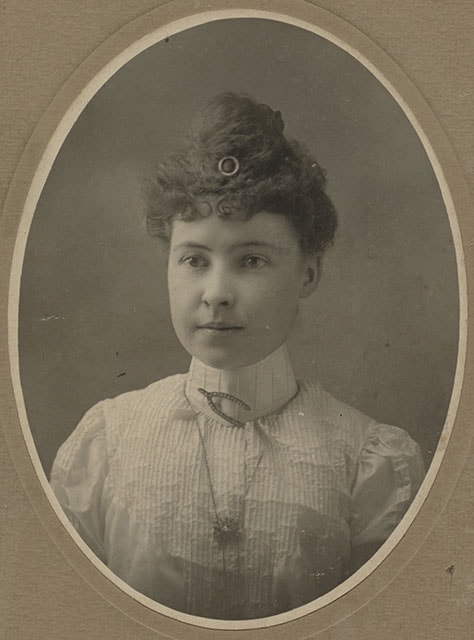
Woman wearing jewelry
https://search.heritageburnaby.ca/link/museumdescription1510
- Repository
- Burnaby Village Museum
- Date
- [between 1880 and 1895]
- Collection/Fonds
- Burnaby Village Museum Photograph collection
- Description Level
- Item
- Physical Description
- 1 photograph : b&w ; 14 x 18.5 cm
- Scope and Content
- Photograph is a studio portrait of an unidentified young woman with her curly hair put up and decorated with a round hair pin in the front. She is wearing a white blouse with high neck, and is wearing a brooch shaped like a tuning fork or a wishbone and has a pendent around her neck.
- Repository
- Burnaby Village Museum
- Collection/Fonds
- Burnaby Village Museum Photograph collection
- Description Level
- Item
- Physical Description
- 1 photograph : b&w ; 14 x 18.5 cm
- Material Details
- printed on the card mount, recto, l.r. "Steele & Co./ LTD/ Winnipeg & Calgary"
- The photograph is printed in an oval shape, and mounted on a card supplied by the photo studio. There are scribbles on verso of cardboard.
- Scope and Content
- Photograph is a studio portrait of an unidentified young woman with her curly hair put up and decorated with a round hair pin in the front. She is wearing a white blouse with high neck, and is wearing a brooch shaped like a tuning fork or a wishbone and has a pendent around her neck.
- Subjects
- Adornment - Jewelry
- Clothing
- Accession Code
- BV985.5886.1
- Access Restriction
- No restrictions
- Reproduction Restriction
- No known restrictions
- Date
- [between 1880 and 1895]
- Media Type
- Photograph
- Scan Resolution
- 600
- Scan Date
- 2024-02-27
- Photographer
- Steele & Co.
- Notes
- Title based on contents of photograph
Images
![Woman wearing jewelry, [between 1880 and 1895] thumbnail](/media/hpo/_Data/_BVM_Images/1985/1985_5886_0001_001.jpg)
![Woman with glasses, [between 1880 and 1895] thumbnail](/media/hpo/_Data/_BVM_Images/1985/1985_5897_0001_002.jpg?width=280)
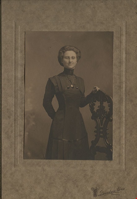
Woman with glasses
https://search.heritageburnaby.ca/link/museumdescription1522
- Repository
- Burnaby Village Museum
- Date
- [between 1880 and 1895]
- Collection/Fonds
- Burnaby Village Museum Photograph collection
- Description Level
- Item
- Physical Description
- 1 photograph : sepia photogravure ; 9.5 x 14 cm
- Scope and Content
- Photogravure is from a studio portrait of an unidentified woman wearing a dark dress and eye glasses, standing by an ornate wooden post. She is wearing a leaf-shaped pendant around her neck.
- Repository
- Burnaby Village Museum
- Collection/Fonds
- Burnaby Village Museum Photograph collection
- Description Level
- Item
- Physical Description
- 1 photograph : sepia photogravure ; 9.5 x 14 cm
- Material Details
- printed on the card mount, recto, l.r. "[emblem in shape of sheaf of wheat] Davidson Bros/ BRANDON,/ MAN."
- The photogravure is mounted on a card, then mounted inside a folder, with a protective tissue paper.
- Scope and Content
- Photogravure is from a studio portrait of an unidentified woman wearing a dark dress and eye glasses, standing by an ornate wooden post. She is wearing a leaf-shaped pendant around her neck.
- Subjects
- Clothing
- Accession Code
- BV985.5897.1
- Access Restriction
- No restrictions
- Reproduction Restriction
- No known restrictions
- Date
- [between 1880 and 1895]
- Media Type
- Photograph
- Scan Resolution
- 600
- Scan Date
- 2024-02-27
- Photographer
- Davidson Brothers
- Notes
- Title based on contents of photograph
Images
![Woman with glasses, [between 1880 and 1895] thumbnail](/media/hpo/_Data/_BVM_Images/1985/1985_5897_0001_002.jpg)
![Young man in uniform, [188-] thumbnail](/media/hpo/_Data/_BVM_Images/1985/1985_5895_0001_001.jpg?width=280)
Young man in uniform
https://search.heritageburnaby.ca/link/museumdescription1520
- Repository
- Burnaby Village Museum
- Date
- [188-]
- Collection/Fonds
- Burnaby Village Museum Photograph collection
- Description Level
- Item
- Physical Description
- 1 photograph : b&w ; 10.5 x 17 cm
- Scope and Content
- Photograph is a studio portrait of an unidentified young man in a uniform standing in front of a chair and beside a studio prop that looks like a staircase to a building. The painted backdrop is of a garden scene. On his collars, there are metal pins in the shape of "P137" or "P187"
- Repository
- Burnaby Village Museum
- Collection/Fonds
- Burnaby Village Museum Photograph collection
- Description Level
- Item
- Physical Description
- 1 photograph : b&w ; 10.5 x 17 cm
- Material Details
- printed on the card mount, recto, b. "Wilson + Sons. PHOTOGRAPHERS.", verso, u.l. "Day and/ Electric Light/ Studios.", c. "Wilson + Sons", l.r. "95/ HARROW ROAD,/ PADDINGTON GREEN/ LONDON, W.", b. "COPIES OF THIS CAN ALWAYS BE HAD BY QUOTING/ Portraits copied to any size and coloured/ in Oil, Water Colour or Crayon."
- The photograph is mounted on card supplied by the photographic studio
- Scope and Content
- Photograph is a studio portrait of an unidentified young man in a uniform standing in front of a chair and beside a studio prop that looks like a staircase to a building. The painted backdrop is of a garden scene. On his collars, there are metal pins in the shape of "P137" or "P187"
- Subjects
- Clothing - Uniforms
- Accession Code
- BV985.5895.1
- Access Restriction
- No restrictions
- Reproduction Restriction
- No known restrictions
- Date
- [188-]
- Media Type
- Photograph
- Scan Resolution
- 600
- Scan Date
- 2024-02-27
- Photographer
- Wilson and Sons Photographers
- Notes
- Title based on contents of photograph
Images
![Young man in uniform, [188-] thumbnail](/media/hpo/_Data/_BVM_Images/1985/1985_5895_0001_001.jpg)
![Young riders on C.W. Parker Carousel at the PNE, [1960-1969] thumbnail](/media/hpo/_Data/_BVM_Images/2015/2015_0041_0007.jpg?width=280)
Young riders on C.W. Parker Carousel at the PNE
https://search.heritageburnaby.ca/link/museumdescription4972
- Repository
- Burnaby Village Museum
- Date
- [1960-1969]
- Collection/Fonds
- Keith Jamieson fonds
- Description Level
- Item
- Physical Description
- 1 photograph : colour ; 25.3 cm x 18.8 cm
- Scope and Content
- Photograph of four young riders on the C.W. Parker carouselno. 119 at the Pacific National Exhibition (PNE). The carousel is not yet in motion. A boy wearing shorts is seated on an outside horse, with a girl seated next to him on a middle horse. A second girl is seated on an inside horse.
- Repository
- Burnaby Village Museum
- Collection/Fonds
- Keith Jamieson fonds
- Description Level
- Item
- Physical Description
- 1 photograph : colour ; 25.3 cm x 18.8 cm
- Scope and Content
- Photograph of four young riders on the C.W. Parker carouselno. 119 at the Pacific National Exhibition (PNE). The carousel is not yet in motion. A boy wearing shorts is seated on an outside horse, with a girl seated next to him on a middle horse. A second girl is seated on an inside horse.
- Subjects
- Recreational Devices - Carousels
- Accession Code
- BV015.41.7
- Date
- [1960-1969]
- Media Type
- Photograph
- Arrangement
- Scrapbooks were arranged by Keith and Pat Jamieson before donation.
- Notes
- Title based on contents of photograph
- The photograph was removed from the scrapbook titled, "Parker Carousel Volume I - Saving and Restoring the C.W. Parker Carousel #119" (BV015.41.1). The scrapbook contained newspaper clippings, correspondence, newsletters and original photographs documenting "The Friends of the Carousel" fundraising endeavours as well as the restoration and installation of the Parker Carousel #119. The carousel was rescued from the PNE and re-installed at the Burnaby Village Museum.
- Photograph print created from negative BV015.41.11
Images
![Young riders on C.W. Parker Carousel at the PNE, [1960-1969] thumbnail](/media/hpo/_Data/_BVM_Images/2015/2015_0041_0007.jpg)