Narrow Results By
Decade
- 2020s 70
- 2010s 132
- 2000s 227
- 1990s 354
- 1980s 372
- 1970s 569
- 1960s 346
- 1950s 419
- 1940s
- 1930s 365
- 1920s 314
- 1910s 238
- 1900s 119
- 1890s
- 1880s 12
- 1870s 12
- 1860s 12
- 1850s 10
- 1840s 5
- 1830s 3
- 1820s 3
- 1810s 3
- 1800s 3
- 1790s 2
- 1780s 2
- 1770s 2
- 1760s 2
- 1750s 2
- 1740s 2
- 1730s 2
- 1720s
- 1710s 2
- 1700s 2
- 1690s 2
- 1680s 2
- 1670s 1
- 1660s 1
- 1650s 1
- 1640s 1
- 1630s 1
- 1620s 1
- 1610s 1
- 1600s 1
Subject
- Accidents - Automobile Accidents 2
- Accidents - Train Accidents 2
- Advertising Medium - Signs and Signboards 2
- Aerial Photographs 1
- Agriculture - Farms 8
- Agriculture - Fruit and Berries 4
- Animals - Birds 1
- Animals - Cats 1
- Animals - Dogs 1
- Animals - Horses 3
- Animals - Poultry 1
- Building - Agricultural 2
![Snow scene on Mount Seymour, [between 1939 and 1949] (date of orignals), copied 2008 thumbnail](/media/hpo/_Data/_BVM_Images/2008/2008_0017_0016_001.jpg?width=280)
Snow scene on Mount Seymour
https://search.heritageburnaby.ca/link/museumdescription2927
- Repository
- Burnaby Village Museum
- Date
- [between 1939 and 1949] (date of orignals), copied 2008
- Collection/Fonds
- Pixie McGeachie fonds
- Description Level
- Item
- Physical Description
- 1 photograph (tiff) : b&w ; 600 dpi
- Scope and Content
- Photograph of a snow scene with snow covered coniferous trees and skiis on Mount Seymour, North Vancouver. Pairs of skiis and poles are standing erect in a thick layer of snow.
- Repository
- Burnaby Village Museum
- Collection/Fonds
- Pixie McGeachie fonds
- Description Level
- Item
- Physical Description
- 1 photograph (tiff) : b&w ; 600 dpi
- Scope and Content
- Photograph of a snow scene with snow covered coniferous trees and skiis on Mount Seymour, North Vancouver. Pairs of skiis and poles are standing erect in a thick layer of snow.
- Subjects
- Natural Phenomena - Snow
- Geographic Features - Forests
- Geographic Features - Mountains - British Columbia
- Sports - Skiing
- Accession Code
- BV008.17.16
- Access Restriction
- No restrictions
- Reproduction Restriction
- May be restricted by third party rights
- Date
- [between 1939 and 1949] (date of orignals), copied 2008
- Media Type
- Photograph
- Notes
- Title based on contents of photograph
Images
![Snow scene on Mount Seymour, [between 1939 and 1949] (date of orignals), copied 2008 thumbnail](/media/hpo/_Data/_BVM_Images/2008/2008_0017_0016_001.jpg)
![Survey and Subdivision plans in New Westminster District Group 1 & Group 2 - Port Moody, Surrey
, [1898-1910] thumbnail](/media/hpo/_Data/_BVM_Cartographic_Material/1977/1977_0093_0073_001.jpg?width=280)
Survey and Subdivision plans in New Westminster District Group 1 & Group 2 - Port Moody, Surrey
https://search.heritageburnaby.ca/link/museumdescription7042
- Repository
- Burnaby Village Museum
- Date
- [1898-1910]
- Collection/Fonds
- Burnaby Village Museum Map collection
- Description Level
- File
- Physical Description
- 10 plans : graphite and ink on paper and linen; various sizes mounted on 2 sides of cardboard 76 x 102 cm
- Scope and Content
- File consists of a large board with four plans in New Westminster District mounted on one side and six plans mounted on the other side. Side A: 1. Plan : black ink and graphite on paper ; 46.5 x 37.5 cm. Title reads: "Bon Accord Hatchery / Sec 6 B5N R1W". Signed by Albert J. Hill P.L.S. August 1…
- Repository
- Burnaby Village Museum
- Collection/Fonds
- Burnaby Village Museum Map collection
- Description Level
- File
- Physical Description
- 10 plans : graphite and ink on paper and linen; various sizes mounted on 2 sides of cardboard 76 x 102 cm
- Material Details
- Scales vary (One chain equals 792 inches)
- Indexed number on tape on edge of board reads "73"
- Scope and Content
- File consists of a large board with four plans in New Westminster District mounted on one side and six plans mounted on the other side. Side A: 1. Plan : black ink and graphite on paper ; 46.5 x 37.5 cm. Title reads: "Bon Accord Hatchery / Sec 6 B5N R1W". Signed by Albert J. Hill P.L.S. August 12, 1903. Plan covers land identified as Section 6, Section 7, Located along the south shore of the Fraser River in Port Mann (Geographic location: Surrey). 2. Plan : black ink and graphite on paper ; 36 x 31 cm. Title reads: "Survey of Portions of Sec. 20 B5N R2W". Plan is stamped in red ink: "Albert J. Hill, Civil Engineer". Scale 4 chains = 1 inch. 3. Plan : black ink on linen ; 14 x 23 cm. Title reads:"Port Moody". Plan covers sections in Lot 191 (District Lot 191) bordered by Burrard Inlet to the west and Lot 235 and Lot 233 to the south. Streets identified include Water Street, Beauregard Street, Yonge Street, Clinton Street and Oxford Street. 4. Plan: graphite and ink on paper ; 43.5 x 64.5 cm. Title reads: "Sketch Plan Approved by Council [sic] / _[sic]1898". (No identifying geographic landmarks provided) Side B: 1. Plan : graphite on paper ; 53.5 x 31 cm. Title reads: "Plan of Lot 13, Gr. II, N.W. Dist". Sketch plan covers area along the Fraser River in District Lot 13, New Westminster District, Group 2. District Lot 13 is bordered by District Lot 14 (to the west) and Lot 12 (to the east). Natural geographic features within District Lot 13 are noted as "dense brush and fallen timber / sallal / rough spruce and cedar / swamp / fine alder / sallal / fine alder bottom land / fine brook". Scale: 3 chains = 1 inch (Geographic location: Surrey) 2. Plan : black ink on paper ; 50.5 x 34.5 cm. Title reads: "Indian Reserve / Opposite / New Westminster". Plan covers area on the south shore of the Fraser River in New Westminster District Group 2 in an area known as Brownsville. Lots are identified as District Lots 1, 2, 3, 4, 18, 17 and 8 and Sections A and B. Two areas of land are noted as "Indian Reserve"; one 6.3 acre parcel and one 104.25 acre parcel, both within District Lot 1. Note on plan reads: "N.B. this plan shows reserves and adjacent properties as they are on the ground". (Geographic location: Surrey) 3. Plan : black and col. ink on paper ; 19.5 x 31.5 cm. Title reads: "Bon Accord Road". Plan shows elevation. "Average section 10 feet = 1 inch". Plan is stamped in red ink: "Albert J. Hill, Civil Engineer and Provincial Land Surveyor, New Westminster, B.C." (Geographic location: Surrey) 4. Plan : black and col. ink on linen ; 16.5 x 25.5 cm. (no formal title) Plan covers area of Section 35, south of Yale Wagon Road and east of Quible Road. Plan is signed by "Albert J. Hill / B.C.L.S." (Geographic location: Surrey) 5. Plan: black and col. ink on linen ; 22.5 x 22.5 cm. (no formal title) Plan covers area between Yale Road and Townline Road in Surrey. Scale: 4 chains = 1 inch. Plan is signed by Albert J. Hill B.C.L.S. [190-] (Geographic location: Surrey) 6. Plan : graphite on paper ; 24 x 54 cm. (no formal title) Plan covers sectioned areas along Bon Accord Road. Sections are identified as " Sec. 8 / T.F. Patterson"; "Sec. 9 / Russell"; "Elliott_Burnett_Crean / Sec. 16"; "Dom. Govt. / Sec. 17". (Geographic location: Surrey, beneath the Port Mann bridge)
- Names
- ʷməθkʷəy̓əm (Musqueam)
- Accession Code
- HV977.93.73
- Access Restriction
- No restrictions
- Reproduction Restriction
- No known restrictions
- Date
- [1898-1910]
- Media Type
- Cartographic Material
- Scan Resolution
- 600
- Scan Date
- 2023-06-26
- Notes
- Title based on contents of file
- Note re plan 2B: The sight of Brownsville was also the former site of the Qayqayt First Nation and one of the main summer villages of the Kwantlen and ʷməθkʷəy̓əm (Musqueam) peoples
Zoomable Images
![Survey and Subdivision plans in New Westminster District Group 1 & Group 2 - Port Moody, Surrey
, [1898-1910] thumbnail](/media/hpo/_Data/_BVM_Cartographic_Material/1977/1977_0093_0073_003_seadragon/1977_0093_0073_003.jpg?w=280)
Survey and Subdivision plans in New Westminster District Group 1 & Group 2 - Port Moody, Surrey , [1898-1910]
Zoom into Image
![Survey and Subdivision plans in New Westminster District Group 2 - Surrey, Delta
, [1898-1910] thumbnail](/media/hpo/_Data/_BVM_Cartographic_Material/1977/1977_0093_0078_001.jpg?width=280)
Survey and Subdivision plans in New Westminster District Group 2 - Surrey, Delta
https://search.heritageburnaby.ca/link/museumdescription7047
- Repository
- Burnaby Village Museum
- Date
- [1898-1910]
- Collection/Fonds
- Burnaby Village Museum Map collection
- Description Level
- File
- Physical Description
- 10 plans : graphite and ink on paper and linen; various sizes mounted on 2 sides of cardboard 76 x 102 cm
- Scope and Content
- File consists of a large board with four plans in New Westminster District mounted on one side and six plans mounted on the other side. Side A: 1. Plan : black ink on paper with colour (no formal title). Plan covers area in New Westminster District, Group 2 situated along the south shore of the …
- Repository
- Burnaby Village Museum
- Collection/Fonds
- Burnaby Village Museum Map collection
- Description Level
- File
- Physical Description
- 10 plans : graphite and ink on paper and linen; various sizes mounted on 2 sides of cardboard 76 x 102 cm
- Material Details
- Scales vary
- Indexed number on tape on edge of board reads "78"
- Scope and Content
- File consists of a large board with four plans in New Westminster District mounted on one side and six plans mounted on the other side. Side A: 1. Plan : black ink on paper with colour (no formal title). Plan covers area in New Westminster District, Group 2 situated along the south shore of the Fraser River identified as "Indian Reserve / Turner 1868" situated in District Lot 1 between District Lot 2 identified as "Mohun's Line" and "Herring's Line" bordered by lots B and A. Includes note "see plan of subdivision of Lots 3 & 4 Gr. 2". (Geographic location: Surrey) 2. Plan : graphite on paper ; Title reads: "B5N R2W, Sec.26_Sec. 28 / Sec. 35_Sec.36". Plan covers a 60 acre parcel in Sec. 35 with Yale wagon road to the south. Scale: 6 chains = 1 inch (Geographic location: Surrey) 3. Plan : black ink on paper ; Title reads: "Survey for Proposed Highway in Indian Reserve Surrey". Plan covers area of land to the northwest of Lot 2 along the shore of the Fraser River and identfies route of proposed highway, proposed tramway as well at the Great Northern Railway and bridge. Scale: 2 chains = 1 inch 4. Plan : black ink on red lined graphing paper ; Title reads: "Sketch Plan Showing Section of Great Northern R. of W. at Point of Crossing of Proposed Ditch". Plan covers area of Lot 2 in New Westminster District, Group 2. (Surrey) Scale: 1 inch = 5 feet. (Geographic location: Surrey) Side B: 1. Plan : black ink on paper ; Title reads: "Plan of Subdivision of a Portion of Section 13, TP2, Surrey Municipality, New Westminster District, B.C.". Plan covers land bordered by Coast Meridian Road (to the east), Bose Road (to the south) and Pike Road (to the west). Surveyed for D.S. Bayners, Nov. 24, 1908. Scale: 5 chains= 1 inch 2. Plan : black ink on linen with colour ; Title reads: "Traverse of the Waterline in front of Lots 3 and 4, Group 2, New Westminster District with G.N. Railway Right of Way". Plan covers area along the southern shore of the Fraser River with a road crossing the Great Northern Railway and leading to a wharf. Scale: 100 feet = 1 inch (Geographic location: Surrey) 3. Plan : black ink on paper ; Title reads: "Survey of the South Boundary of Sec. 12, Township 2, New Westminster District". Plan covers area south of Bose Road and west of Coast Meridean Road and north of McClellen Road. Scale: 400 feet = 1 inch. Sec.12 (Geographic location: Surrey) 4. Plan : graphite on paper ; Title reads: "Plan of Subdivisioin of a part of S.E. 1/4 of Sec. 7, TP 8". Plan covers area of Section 7 in New Westminster District, Group 2, Township 8. Streets are identified running through lot including, Langley Ave., Robinson Ave, Melrose Ave., Hawthorne Ave., Broadway, Bond Ave., Mable Ave., Breene Ave. and McLelland Ave. and Clover Valley Road. Scale: 200 feet = 1 inch. Note in black ink reads: See Bd. 166 for blue print. (Geographic location: Surrey) 5. Plan : graphite on linen ; Title reads: "Sec.20, B5N R2W". Plan covers area north of Yale Road and is subdivided into parts identified as A, B, C, D, E, and unknown. (Geographic location: Surrey) 6. Plan : black ink and graphite on paper ; (no formal title) Plan covers lots surveyed along Ladner Road identified as A, B and Lots 13, 12 and 11. [Geographic location: Delta]
- Accession Code
- HV977.93.78
- Access Restriction
- No restrictions
- Reproduction Restriction
- No known restrictions
- Date
- [1898-1910]
- Media Type
- Cartographic Material
- Scan Resolution
- 600
- Scan Date
- 2023-06-26
- Notes
- Title based on contents of file
- Note re plans 1A & 3A: The sight of Brownsville was also the former site of the Qayqayt First Nation and one of the main summer villages of the Kwantlen and ʷməθkʷəy̓əm (Musqueam) peoples
- Scale is measured in chains and feet. (One chain equals 792 inches)
Zoomable Images
![Survey and Subdivision plans in New Westminster District Group 2 - Surrey, Delta
, [1898-1910] thumbnail](/media/hpo/_Data/_BVM_Cartographic_Material/1977/1977_0093_0078_003_seadragon/1977_0093_0078_003.jpg?w=280)
Survey and Subdivision plans in New Westminster District Group 2 - Surrey, Delta , [1898-1910]
Zoom into Image
![Winter snow scene on Mount Seymour, [between 1939 and 1949] (date of orignals), copied 2008 thumbnail](/media/hpo/_Data/_BVM_Images/2008/2008_0017_0011_001.jpg?width=280)
Winter snow scene on Mount Seymour
https://search.heritageburnaby.ca/link/museumdescription2922
- Repository
- Burnaby Village Museum
- Date
- [between 1939 and 1949] (date of orignals), copied 2008
- Collection/Fonds
- Pixie McGeachie fonds
- Description Level
- Item
- Physical Description
- 1 photograph (tiff) : b&w ; 600 dpi
- Scope and Content
- Photograph of snow covered trees on Mount Seymour.
- Repository
- Burnaby Village Museum
- Collection/Fonds
- Pixie McGeachie fonds
- Description Level
- Item
- Physical Description
- 1 photograph (tiff) : b&w ; 600 dpi
- Scope and Content
- Photograph of snow covered trees on Mount Seymour.
- Subjects
- Natural Phenomena - Snow
- Geographic Features - Forests
- Geographic Features - Mountains - British Columbia
- Accession Code
- BV008.17.11
- Access Restriction
- No restrictions
- Reproduction Restriction
- May be restricted by third party rights
- Date
- [between 1939 and 1949] (date of orignals), copied 2008
- Media Type
- Photograph
- Notes
- Title based on contents of photograph
Images
![Winter snow scene on Mount Seymour, [between 1939 and 1949] (date of orignals), copied 2008 thumbnail](/media/hpo/_Data/_BVM_Images/2008/2008_0017_0011_001.jpg)

Burnaby South High School Cenotaph & Memorial Tennis Courts
https://search.heritageburnaby.ca/link/landmark547
- Repository
- Burnaby Heritage Planning
- Description
- This memorial comprises a cenotaph and three tennis courts: the former a monument of British Columbia granite inscribed with the names of fifty-one students of Burnaby South High School who lost their lives in the Second World War; and the latter a living memorial to these former students.
- Associated Dates
- 1948
- Formal Recognition
- Heritage Designation, Community Heritage Register
- Street View URL
- Google Maps Street View
- Repository
- Burnaby Heritage Planning
- Geographic Access
- Southoaks Crescent
- Associated Dates
- 1948
- Formal Recognition
- Heritage Designation, Community Heritage Register
- Enactment Type
- Bylaw No. 9807
- Enactment Date
- 23/11/1992
- Description
- This memorial comprises a cenotaph and three tennis courts: the former a monument of British Columbia granite inscribed with the names of fifty-one students of Burnaby South High School who lost their lives in the Second World War; and the latter a living memorial to these former students.
- Heritage Value
- This memorial is important for its spiritual, symbolic, and cultural associations for the former students of Burnaby South High School, and for all youth in the community. The cenotaph is of personal significance to the families of those who lost their lives. The unusual combination of cenotaph and living memorial - the tennis courts - represents a rare statement of a community's commitment to not allow the sacrifice of its youth to be forgotten by providing an active facility which draw people to the place on a regular basis rather than just on occasions of remembrance. As such it is an important symbol of a humanitarian ethic. In combination with the Kingsway East School, now rehabilitated as the Alan Emmott Centre, this memorial represents a valuable haven of green-space and recreation in the high-density urban development that now surrounds it.
- Defining Elements
- Key elements that define the heritage character of the Burnaby South High School Cenotaph & Memorial Tennis Courts include the: - location of the cenotaph adjacent to the living memorial - spatial association of this memorial and the remaining school building - physical fabric of both the granite monument and the tennis courts
- Historic Neighbourhood
- Edmonds (Historic Neighbourhood)
- Planning Study Area
- Kingsway-Beresford Area
- Function
- Primary Current--Public Feature
- Primary Historic--Public Feature
- Community
- Burnaby
- Cadastral Identifier
- P.I.D. No. 016-367-154 Legal Description: Lot 1, District Lot 96, Group 1 New Westminster District, Plan 86581
- Boundaries
- Burnaby South High School Cenotaph & Memorial Tennis Courts is comprised of a single municipally-owned property located at 6650 Southoaks Crescent, Burnaby.
- Area
- 6,070.00
- Contributing Resource
- Building
- Landscape Feature
- Structure
- Ownership
- Public (local)
- Documentation
- Heritage Site Files: PC77000 20. City of Burnaby Planning and Building Department, 4949 Canada Way, Burnaby, B.C., V5G 1M2
- Street Address
- 6650 Southoaks Crescent
- Street View URL
- Google Maps Street View
Images


Central Park
https://search.heritageburnaby.ca/link/landmark728
- Repository
- Burnaby Heritage Planning
- Geographic Access
- Imperial Street
- Associated Dates
- 1891
- Heritage Value
- In 1860, as the Royal Engineers constructed the road from New Westminster to Vancouver (now Kingsway), a military reserve was set aside at the trail's highest point along the ridge. This reserve provided a particularly good scenic look-out since the original forest had burned down prior to 1860, the remaining stumps offered unobstructed views. By the 1880s, the city council of both New Westminster and Vancouver eyed the reserve as potential recreation ground. As construction of the tram line was underway, the Provincial Government moved to designate the whole reserve as a park. On January 14, 1891, the Lieutenant Governor of British Columbia proclaimed it as a public recreation ground.
- Historic Neighbourhood
- Central Park (Historic Neighbourhood)
- Planning Study Area
- Maywood Area
- Street Address
- 3883 Imperial Street
- Street View URL
- Google Maps Street View
Images

Dinner for Miss Creeden
https://search.heritageburnaby.ca/link/museumlibrary7356
- Repository
- Burnaby Village Museum
- Collection
- Reference Collection
- Material Type
- Moving Images
- Call Number
- 388.46 BCH
- Contributor
- British Columbia Electric Company
- Place of Publication
- [British Columbia, Canada]
- Publisher
- BC Hydro
- Publication Date
- 1947
- Physical Description
- 1 videodisc (36 min.) : sd., col ; 4 3/4 in.
- Library Subject (LOC)
- Natural gas industry
- World War, 1914-1918--Mobilization
- World War, 1939-1945--Mobilization
- Street-railroads
- Electric railroads
- Transportation
- British Columbia--History
- Notes
- Summary: Industrial film. A film about the growth of B.C. Electric from 1906 to 1946, built around the story of stenographer Flossie Creeden, the first female office employee of the company. Footage includes: Goldstream power plant; Vancouver natural gas facilities; BC Electric Railway lines in Fraser Valley; Stave Falls generator plant; Alouette Lake and Ruskin plants; 1939 royal visit; BCE employee's newsletter; A.E. Grauer family at home; office scenes; plans & construction at Bridge River project; BCE employee's service in World Wars I & II; BCE streetcar and trolley bus services
- Credit notes: producer: Lew M. Parry; director: Lew M. Parry; photography: John Young; script: Cecil Maiden; sound: S.G. Wilson; narrator: A.E. Grauer; sponsored/presented by: British Columbia Electric Company; producing agency/company: Trans-Canada Films Ltd.
Fire insurance plans - Greater Vancouver - Volume XVIII - Municipality of Burnaby
https://search.heritageburnaby.ca/link/museumdescription17798
- Repository
- Burnaby Village Museum
- Date
- 1927-1950
- Collection/Fonds
- Burnaby Village Museum Map collection
- Description Level
- Item
- Physical Description
- 22 plans on 12 sheets : col. lithographic print ; 64 x 54 cm
- Scope and Content
- Item consists of fire insurance plans titled "Greater Vancouver / Volume XVIII / Municipality / of Burnaby" surveyed May 1927, revised in October 1940 and September 1950. Includes a two page key plan (G and H) and twenty associated plans numbered; 1801; 1802; 1803; 1804; 1805; 1806; 1807; 1808; 18…
- Repository
- Burnaby Village Museum
- Collection/Fonds
- Burnaby Village Museum Map collection
- Description Level
- Item
- Physical Description
- 22 plans on 12 sheets : col. lithographic print ; 64 x 54 cm
- Material Details
- Scales between [1:600] and [1:6000]
- Scope and Content
- Item consists of fire insurance plans titled "Greater Vancouver / Volume XVIII / Municipality / of Burnaby" surveyed May 1927, revised in October 1940 and September 1950. Includes a two page key plan (G and H) and twenty associated plans numbered; 1801; 1802; 1803; 1804; 1805; 1806; 1807; 1808; 1809; 1810; 1811; 1812; 1813; 1814; 1815; 1819; 1820; 1821; 1822 and 1832.
- Publisher
- Plan Department of Fire Branch of British Columbia Underwriters' Association
- Accession Code
- BV987.1.70
- Access Restriction
- No restrictions
- Reproduction Restriction
- May be restricted by third party rights
- Date
- 1927-1950
- Media Type
- Cartographic Material
- Scan Resolution
- 400
- Scan Date
- 11/17/2021
- Notes
- Title based on contents of item
- Scale 1 inch = 50 feet
- These plans were removed from a bound book with labels on cover page reading: "Plan No. 90 / THIS INSURANCE PLAN / of / Vancouver VOLUME "8" / IN THE PROPERTY OF THE / British Columbia Insurance Underwriter's Association / Vancouver B.C. / AND IS LOANED / MELVILLE F. THOMSON CO. .../ Date May 26th, 1934"; / "Plan No. 74 / THIS INSURANCE PLAN / OF / VANCOUVER VOLUME "9"" / Plan No. 11 / THIS INSURANCE PLAN / OF / BURNABY VOLUMES 15-19" / "THIS PLAN IS THE PROPERTY OF / THE / BRITISH LAW INSURANCE COMPANY / LIMITED"
- Contact Burnaby Village Museum to view associated fire insurance plans
Fire insurance plans - Greater Vancouver - Volume XVII - Municipality of Burnaby
https://search.heritageburnaby.ca/link/museumdescription17797
- Repository
- Burnaby Village Museum
- Date
- 1927-1950
- Collection/Fonds
- Burnaby Village Museum Map collection
- Description Level
- Item
- Physical Description
- 4 plans on 4 sheets : col. lithographic prints
- Scope and Content
- Item consists of fire insurance plans titled "Greater Vancouver / Volume XVII / Municipality / of Burnaby" surveyed May 1927, revised in October 1940 and September 1950. Includes a two page key plan (E and F) and two associated plans numbered 1729 and 1738 (located within District Lot 35).
- Repository
- Burnaby Village Museum
- Collection/Fonds
- Burnaby Village Museum Map collection
- Description Level
- Item
- Physical Description
- 4 plans on 4 sheets : col. lithographic prints
- Scope and Content
- Item consists of fire insurance plans titled "Greater Vancouver / Volume XVII / Municipality / of Burnaby" surveyed May 1927, revised in October 1940 and September 1950. Includes a two page key plan (E and F) and two associated plans numbered 1729 and 1738 (located within District Lot 35).
- Publisher
- Plan Department of Fire Branch of British Columbia Underwriters' Association
- Accession Code
- BV987.1.70
- Access Restriction
- No restrictions
- Reproduction Restriction
- May be restricted by third party rights
- Date
- 1927-1950
- Media Type
- Cartographic Material
- Historic Neighbourhood
- Central Park (Historic Neighbourhood)
- Planning Study Area
- Garden Village Area
- Scan Resolution
- 400
- Scan Date
- 2021-11-17
- Notes
- Title based on contents of item
- These plans were removed from a bound book with labels on cover page reading: "Plan No. 90 / THIS INSURANCE PLAN / of / Vancouver VOLUME "8" / IN THE PROPERTY OF THE / British Columbia Insurance Underwriter's Association / Vancouver B.C. / AND IS LOANED / MELVILLE F. THOMSON CO. .../ Date May 26th, 1934"; / "Plan No. 74 / THIS INSURANCE PLAN / OF / VANCOUVER VOLUME "9"" / Plan No. 11 / THIS INSURANCE PLAN / OF / BURNABY VOLUMES 15-19" / "THIS PLAN IS THE PROPERTY OF / THE / BRITISH LAW INSURANCE COMPANY / LIMITED"
- Contact Burnaby Village Museum to view associated fire insurance plans XVIII
Fire insurance plans - Greater Vancouver - Volume XV - Municipality of Burnaby
https://search.heritageburnaby.ca/link/museumdescription17795
- Repository
- Burnaby Village Museum
- Date
- 1927-1940
- Collection/Fonds
- Burnaby Village Museum Map collection
- Description Level
- Item
- Physical Description
- 11 plans on 8 sheets : col. lithographic print ; 64 x 54 cm
- Scope and Content
- Item consists of fire insurance plans titled "Greater Vancouver / Volume XV / Municipality / of Burnaby" surveyed May 1927 and revised October 1940. Volume XV includes a two page Key Plan (A and B) identifying associated plan numbers and district lots and nine numbered fire insurance plans identifi…
- Repository
- Burnaby Village Museum
- Collection/Fonds
- Burnaby Village Museum Map collection
- Description Level
- Item
- Physical Description
- 11 plans on 8 sheets : col. lithographic print ; 64 x 54 cm
- Material Details
- Scales between [1:600] and [1:6000]
- Scope and Content
- Item consists of fire insurance plans titled "Greater Vancouver / Volume XV / Municipality / of Burnaby" surveyed May 1927 and revised October 1940. Volume XV includes a two page Key Plan (A and B) identifying associated plan numbers and district lots and nine numbered fire insurance plans identified as; 1507; 1508 ; 1517; 1518; 1519; 1520;1521; 1531and 1532.
- Publisher
- Plan Department of Fire Branch of British Columbia Underwriters' Association
- Accession Code
- BV987.1.70
- Access Restriction
- No restrictions
- Reproduction Restriction
- May be restricted by third party rights
- Date
- 1927-1940
- Media Type
- Cartographic Material
- Historic Neighbourhood
- Vancouver Heights (Historic Neighbourhood)
- Planning Study Area
- Burnaby Heights Area
- Willingdon Heights Area
- Scan Resolution
- 400
- Notes
- Title based on contents of item
- These plans are contained within a bound book with labels on cover page reading: "Plan No. 90 / THIS INSURANCE PLAN / of / Vancouver VOLUME "8" / IN THE PROPERTY OF THE / British Columbia Insurance Underwriter's Association / Vancouver B.C. / AND IS LOANED / MELVILLE F. THOMSON CO. .../ Date May 26th, 1934"; / "Plan No. 74 / THIS INSURANCE PLAN / OF / VANCOUVER VOLUME "9"" / Plan No. 11 / THIS INSURANCE PLAN / OF / BURNABY VOLUMES 15-19" / "THIS PLAN IS THE PROPERTY OF / THE / BRITISH LAW INSURANCE COMPANY / LIMITED"
- Fire insurance plans cover various district lots in Burnaby including: District Lot 116,121, 186 and 187.
- Sticker adhered to Key Plan B reads: "
- Contact Burnaby Village Museum to view fire insurance plans that are part of Volume XV
Progress report
https://search.heritageburnaby.ca/link/museumlibrary7355
- Repository
- Burnaby Village Museum
- Collection
- Reference Collection
- Material Type
- Moving Images
- Call Number
- 388.46 BCH VR
- Contributor
- British Columbia Electric Company
- Place of Publication
- [British Columbia, Canada]
- Publisher
- BC Hydro
- Publication Date
- c1947
- Physical Description
- 1 videodisc (13 min.) : sd., b&w. ; 4 3/4 in.
- Library Subject (LOC)
- Natural gas industry
- Local transit
- Hydroelectric power plants
- Electric railroads
- Electric power-plants
- Transportation
- British Columbia--History
- Subjects
- Transportation
- Geographic Access
- Vancouver
- Notes
- Summary: Promotional film. The BC Electric Railway Company's $50 million post-war expansion and modernization program, to be completed by 1950. Includes: expansion of transit services, including start of the switch from streetcars to trolley buses; water gas plant; explanation of the Bridge River project, with footage of construction (including La Joie Falls storage dam); Lower Mainland power sub-stations. Various Vancouver street scenes, especially Fraser Street and downtown
- Credit note : sponsored/presented by: British Columbia Electric Company; producer: Lew M. Parry; producing agency/company: Trans-Canada Films Ltd.
A manual of organic materia medica : being a guide to materia medica of the vegetable and animal kingdoms, for the use of students, druggists, pharmacists, and physicians
https://search.heritageburnaby.ca/link/museumlibrary439
- Repository
- Burnaby Village Museum
- Author
- Maisch, John M. (John Michael), 1831-1893
- Maisch, Henry C. C. (Henry Charles Christian), 1865-1901
- Edition
- 7th ed., rev.
- Publication Date
- 1899
- Call Number
- 615.1 MAI
- Repository
- Burnaby Village Museum
- Collection
- Special Collection
- Material Type
- Book
- Accession Code
- BV988.68.16
- Call Number
- 615.1 MAI
- Edition
- 7th ed., rev.
- Author
- Maisch, John M. (John Michael), 1831-1893
- Maisch, Henry C. C. (Henry Charles Christian), 1865-1901
- Place of Publication
- Philadelphia
- Publisher
- Lea Brothers and Co.
- Publication Date
- 1899
- Printer
- William J. Dornan
- Physical Description
- iii-vi, 523 p. : ill. ; 21 cm.
- Inscription
- inside front page : "Gordon S. Wood" [handwritten in ink] "Kamloops B.C. Jan. 1910"
- Library Subject (LOC)
- Materia medica
- Materia medica, Vegetable
- Botany
- Notes
- Includes index.
- "Seventh edition. Revised by Henry C.C. Maisch."
- "With two hundred and eighty-five illustrations."
- Authors' given name and dates: Maisch, John M. (John Michael), 1831-1893. Maisch, Henry C. C. (Henry Charles Christian), 1865-1901.
A synopsis of the British pharmacopoeia preparations : designed for the use of pharmaceutical and medical students
https://search.heritageburnaby.ca/link/museumlibrary5885
- Repository
- Burnaby Village Museum
- Edition
- 10th ed.
- Publication Date
- c1916
- c1893
- Call Number
- 615.11 HEE 1916
- Repository
- Burnaby Village Museum
- Collection
- Special Collection
- Material Type
- Book
- Accession Code
- BV988.68.13
- Call Number
- 615.11 HEE 1916
- Edition
- 10th ed.
- Place of Publication
- Toronto
- Publisher
- Chas. F. Heebner
- Publication Date
- c1916
- c1893
- Printer
- University of Toronto Press
- Physical Description
- 109 p. ; 20 cm.
- Inscription
- inside front cover: "The J.F. Hartz Co. Limited" [paper sticker label] "Medical Books Toronto" inside front page: "2.00" [handwritten in pencil] "Druggist and Stationer" [purple ink stamp] "G.S. Wood, Phan.B." "Prince George, B.C."
- Library Subject (LOC)
- Pharmacopoeias--Great Britain
- Medicine--Formulae, receipts, prescriptions
- Notes
- Includes index.
- Author full name: Heebner, Chas. F. (Charles Frederick), 1859-1933.
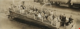
BC Electric Railway Company observation car
https://search.heritageburnaby.ca/link/museumdescription900
- Repository
- Burnaby Village Museum
- Date
- September 1, 1946
- Collection/Fonds
- Burnaby Village Museum Photograph collection
- Description Level
- Item
- Physical Description
- 1 photograph : sepia ; 9.5 x 23.7 cm
- Scope and Content
- Photograph of a BC Electric Railway Company Observation car, fully loaded with people, passing by Harry Bullen Photo studio on 2608 Granville Street. The car number is 123, and on the end of the car is a sign that reads; "Seeing Vancouver / 2 Hour Trip / Fare 50c." A sign on the side of the car re…
- Repository
- Burnaby Village Museum
- Collection/Fonds
- Burnaby Village Museum Photograph collection
- Description Level
- Item
- Physical Description
- 1 photograph : sepia ; 9.5 x 23.7 cm
- Material Details
- inscribed in the negative and printed on recto, l.l. "B.C. ELECTRIC RLY CO OBSERVATION CAR", l.r. " Harry Bullen Photographer. 2608 Granville St. Phone Bay. 8869" stamped on verso, l.l. "SEP 1 - 1946/ 664"
- Scope and Content
- Photograph of a BC Electric Railway Company Observation car, fully loaded with people, passing by Harry Bullen Photo studio on 2608 Granville Street. The car number is 123, and on the end of the car is a sign that reads; "Seeing Vancouver / 2 Hour Trip / Fare 50c." A sign on the side of the car reads; "Sightseeing Car Trips / Leave Robson & Granville / At 10 & 11 AM - 1, 2, 3, 4, 6 & 7 PM / Daily." Behind the car, a store window display of photographs with an awning reads; "Harry Bullen Photographer." Among the passengers in the car are a number of soldiers. Printed at the bottom front of the photograph; "BC Electric Rly Co Observation Car / Harry Bullen Photographer., 2608 Granville St., Phone Bay. 8869."
- Subjects
- Transportation - Electric Railroads
- Geographic Access
- Vancouver
- Accession Code
- HV975.88.1
- Access Restriction
- No restrictions
- Reproduction Restriction
- No known restrictions
- Date
- September 1, 1946
- Media Type
- Photograph
- Related Material
- For another photograph of BCER observation car by Harry Bullen, see HV972.142.1
- Scan Resolution
- 600
- Scan Date
- 2023-06-06
- Photographer
- Bullen, Harry Elder
- Notes
- Title based on caption of photograph
- In "History of Metropolitan Vancouver" at http://www.vancouverhistory.ca/chronology6.htm, it notes that Harry Bullen sold long narrow souvenir photographs of the passengers taken in the car.
Images
B.C. Electric Railway Co. observation car
https://search.heritageburnaby.ca/link/museumdescription218
- Repository
- Burnaby Village Museum
- Date
- 14 Aug. 1942
- Collection/Fonds
- Burnaby Village Museum Photograph collection
- Description Level
- Item
- Physical Description
- 1 photograph : sepia
- Scope and Content
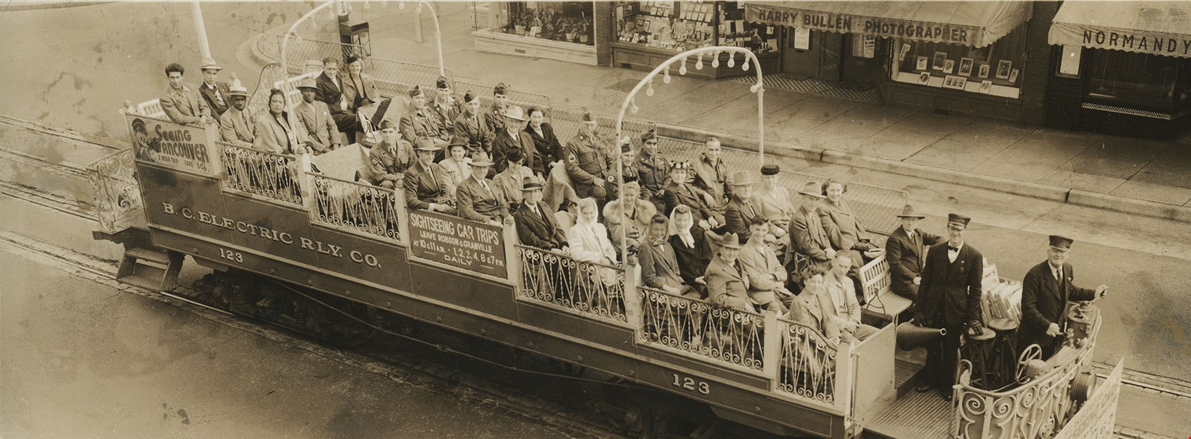
- Photograph of a BC Electric Railway Company Observation car, loaded with people, and conducted by "Dick" Gardner. The car number is 123, and on the rear end of the car is a sign that reads, "SEE VANCOUVER/ TWO HOUR/ TRIP/ FARE 50c." The photograph was probably taken prior to 11am, as there are sign…
- Repository
- Burnaby Village Museum
- Collection/Fonds
- Burnaby Village Museum Photograph collection
- Description Level
- Item
- Physical Description
- 1 photograph : sepia
- Material Details
- printed on recto, b. "B.C. ELECTRIC RLY CO OBSERVATION CAR "DICK" GARDNER CONDUCTOR Harry Bullen Photographer. 2608 Granville St. Phone Bay. 8869." stamped on verso, c.r. "AUG 14 1942"
- Scope and Content
- Photograph of a BC Electric Railway Company Observation car, loaded with people, and conducted by "Dick" Gardner. The car number is 123, and on the rear end of the car is a sign that reads, "SEE VANCOUVER/ TWO HOUR/ TRIP/ FARE 50c." The photograph was probably taken prior to 11am, as there are signs hanging on the car by the front that reads, "NEXT TRIP/ 11 AM" and "NEXT TRIP/ 3 PM". Storefronts are visible directly behind the Observation car. One has a window display of photographs and a large awning. The display window has a sign that reads, "HARRY BULLEN," indicating the car is stopped right in front of the photographer's studio for a souvenir photograph.
- Subjects
- Transportation - Electric Railroads
- Geographic Access
- Vancouver
- Accession Code
- BV985.441.1
- Access Restriction
- No restrictions
- Reproduction Restriction
- No known restrictions
- Date
- 14 Aug. 1942
- Media Type
- Photograph
- Related Material
- The envelope for this photograph is BV985.441.2
- Scan Resolution
- 600
- Scan Date
- 16-Jan-24
- Scale
- 100
- Photographer
- Bullen, Harry Elder
- Notes
- Title based on contents of photograph
Images
B.C. Electric Railway Co. observation car
https://search.heritageburnaby.ca/link/museumdescription4122
- Repository
- Burnaby Village Museum
- Date
- [194-]
- Collection/Fonds
- Burnaby Village Museum Photograph collection
- Description Level
- Item
- Physical Description
- 1 photograph : b&w ; 28.3 cm x 66.7 cm
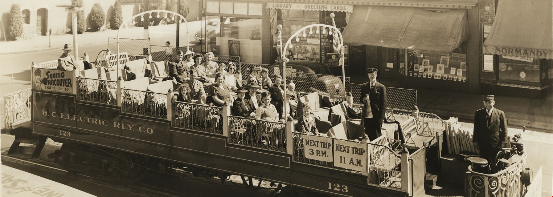
- Scope and Content
- Photograph of a BC Electric Railway Company Observation car, loaded with people, and conducted by Teddy Lyons. The car number is 124, and on the rear end of the car is a sign that reads, "SEEING / VANCOUVER / 2 HOUR TRIP FARE 50c." The photograph was probably taken prior to 10am, as there are sig…
- Repository
- Burnaby Village Museum
- Collection/Fonds
- Burnaby Village Museum Photograph collection
- Description Level
- Item
- Physical Description
- 1 photograph : b&w ; 28.3 cm x 66.7 cm
- Material Details
- printed on recto, "B.C. ELECTRIC RLY CO OBSERVATION CAR "TEDDY LYONS CONDUCTOR Harry Bullen Photographer. 2608 Granville St. Phone Bay. 8869."
- Scope and Content
- Photograph of a BC Electric Railway Company Observation car, loaded with people, and conducted by Teddy Lyons. The car number is 124, and on the rear end of the car is a sign that reads, "SEEING / VANCOUVER / 2 HOUR TRIP FARE 50c." The photograph was probably taken prior to 10am, as there are signs hanging on the car by the front that read, "EXTRA TRIP / 7.00 P.M.", "NEXT TRIP / 4 P.M.", NEXT TRIP / 10 A.M.", and "NEXT TRIP / 2 P.M.". Storefronts are visible directly behind the Observation car. One has a window display of photographs and a large awning. The display window has a sign that reads, "HARRY BULLEN," indicating the car is stopped right in front of the photographer's studio for a souvenir photograph. Teddy Lyons is at the front of the car, holding a small child.
- Subjects
- Transportation - Electric Railroads
- Geographic Access
- Vancouver
- Accession Code
- BV017.26.1
- Access Restriction
- No restrictions
- Reproduction Restriction
- No known restrictions
- Date
- [194-]
- Media Type
- Photograph
- Photographer
- Bullen, Harry Elder
- Notes
- Title based on contents of photograph
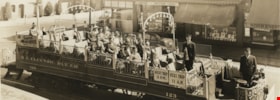
B. C. Electric Railway sightseeing car, No. 124
https://search.heritageburnaby.ca/link/museumdescription91
- Repository
- Burnaby Village Museum
- Date
- [194-]
- Collection/Fonds
- Burnaby Village Museum Photograph collection
- Description Level
- Item
- Physical Description
- 1 photograph : b&w print ; 40.64 x 50.8 cm
- Scope and Content
- Photograph of B. C. Electric Railway sightseeing car, No. 124. The car is on the tracks outside of the Carrall Street Gas Plant with gas storage tower with signage reading "GAS THE MODERN FUEL". Two B.C. Electric conductors at standing at the front of the car and three women are seated at the centr…
- Repository
- Burnaby Village Museum
- Collection/Fonds
- Burnaby Village Museum Photograph collection
- Description Level
- Item
- Physical Description
- 1 photograph : b&w print ; 40.64 x 50.8 cm
- Scope and Content
- Photograph of B. C. Electric Railway sightseeing car, No. 124. The car is on the tracks outside of the Carrall Street Gas Plant with gas storage tower with signage reading "GAS THE MODERN FUEL". Two B.C. Electric conductors at standing at the front of the car and three women are seated at the centre of the car. Signage hanging on the front of the car reads "B.C. ELECTRIC RY. CO. / SIGHTSEEING CARS / Leave Robson & Granville / AM_PM / 10_11_1_2_3_4_6_7 / 2 HOUR TRIP_FARE 50 cts".
- Subjects
- Transportation - Electric Railroads
- Geographic Access
- Vancouver
- Accession Code
- BV988.9.3
- Access Restriction
- No restrictions
- Reproduction Restriction
- No known restrictions
- Date
- [194-]
- Media Type
- Photograph
- Notes
- Title based on contents of photograph
![B.C. Electric Railway tram car on tracks, [194-] thumbnail](/media/hpo/_Data/_BVM_Images/2012/2012_0036_0011_001.jpg?width=280)
B.C. Electric Railway tram car on tracks
https://search.heritageburnaby.ca/link/museumdescription2903
- Repository
- Burnaby Village Museum
- Date
- [194-]
- Collection/Fonds
- Burnaby Village Museum Photograph collection
- Description Level
- Item
- Physical Description
- 1 photograph : b&w ; 6.5 x 9 cm
- Scope and Content
- Photograph of a three-quarters view of the rear and side of an unidentified B.C. Electric Railway interurban tram car on tracks. A conductor is standing in the doorway and possibly the motorman standing at the front door of the street car.
- Repository
- Burnaby Village Museum
- Collection/Fonds
- Burnaby Village Museum Photograph collection
- Description Level
- Item
- Physical Description
- 1 photograph : b&w ; 6.5 x 9 cm
- Scope and Content
- Photograph of a three-quarters view of the rear and side of an unidentified B.C. Electric Railway interurban tram car on tracks. A conductor is standing in the doorway and possibly the motorman standing at the front door of the street car.
- Subjects
- Transportation - Electric Railroads
- Accession Code
- BV012.36.11
- Access Restriction
- No restrictions
- Reproduction Restriction
- No known restrictions
- Date
- [194-]
- Media Type
- Photograph
- Scan Resolution
- 600
- Scan Date
- 2022-07-26
- Notes
- Title based on contents of photograph
- Stamp on verso of photograph reads: "D7"
Images
![B.C. Electric Railway tram car on tracks, [194-] thumbnail](/media/hpo/_Data/_BVM_Images/2012/2012_0036_0011_001.jpg)
![B.C. Electric Railway tram no. 1315 with motorman and conductor, [194-] thumbnail](/media/hpo/_Data/_BVM_Images/2012/2012_0036_0013_001.jpg?width=280)
B.C. Electric Railway tram no. 1315 with motorman and conductor
https://search.heritageburnaby.ca/link/museumdescription2904
- Repository
- Burnaby Village Museum
- Date
- [194-]
- Collection/Fonds
- Burnaby Village Museum Photograph collection
- Description Level
- Item
- Physical Description
- 1 photograph : b&w ; 9 x 6.5 cm
- Scope and Content
- Photograph of tram conductor and motorman with B.C. Electric Railway tram no. 1315. One is standing beside the tram and the other is leaning out the motorman's window. One of the two is likely Norm Davidson.
- Repository
- Burnaby Village Museum
- Collection/Fonds
- Burnaby Village Museum Photograph collection
- Description Level
- Item
- Physical Description
- 1 photograph : b&w ; 9 x 6.5 cm
- Scope and Content
- Photograph of tram conductor and motorman with B.C. Electric Railway tram no. 1315. One is standing beside the tram and the other is leaning out the motorman's window. One of the two is likely Norm Davidson.
- Subjects
- Transportation - Electric Railroads
- Accession Code
- BV012.36.13
- Access Restriction
- No restrictions
- Reproduction Restriction
- No known restrictions
- Date
- [194-]
- Media Type
- Photograph
- Scan Resolution
- 600
- Scan Date
- 2022-07-26
- Notes
- Title based on contents of photograph
- Stamp on verso of photograph reads: "225 _"
Images
![B.C. Electric Railway tram no. 1315 with motorman and conductor, [194-] thumbnail](/media/hpo/_Data/_BVM_Images/2012/2012_0036_0013_001.jpg)
![B.C. Electric Railway tram no. 1317 with motorman, [194-] thumbnail](/media/hpo/_Data/_BVM_Images/2012/2012_0036_0014_001.jpg?width=280)
B.C. Electric Railway tram no. 1317 with motorman
https://search.heritageburnaby.ca/link/museumdescription2905
- Repository
- Burnaby Village Museum
- Date
- [194-]
- Collection/Fonds
- Burnaby Village Museum Photograph collection
- Description Level
- Item
- Physical Description
- 1 photograph : b&w ; 9 x 13 cm
- Scope and Content
- Photograph of B.C. Electric Railway tram no. 1317 with motorman in window (possibly Norm Davidson). The running board reads "Carrall St / Park Ave".
- Repository
- Burnaby Village Museum
- Collection/Fonds
- Burnaby Village Museum Photograph collection
- Description Level
- Item
- Physical Description
- 1 photograph : b&w ; 9 x 13 cm
- Scope and Content
- Photograph of B.C. Electric Railway tram no. 1317 with motorman in window (possibly Norm Davidson). The running board reads "Carrall St / Park Ave".
- Subjects
- Transportation - Electric Railroads
- Accession Code
- BV012.36.14
- Access Restriction
- No restrictions
- Reproduction Restriction
- No known restrictions
- Date
- [194-]
- Media Type
- Photograph
- Scan Resolution
- 600
- Scan Date
- 2022-07-26
- Notes
- Title based on contents of photograph
- Stamp on verso of photograph reads: "927"
Images
![B.C. Electric Railway tram no. 1317 with motorman, [194-] thumbnail](/media/hpo/_Data/_BVM_Images/2012/2012_0036_0014_001.jpg)