![Brookfield, [1896] thumbnail](/media/hpo/_Data/_BVM_Images/1973/1973_0040_0001_001.jpg?width=280)
Brookfield
https://search.heritageburnaby.ca/link/museumdescription988
- Repository
- Burnaby Village Museum
- Date
- [1896]
- Collection/Fonds
- Burnaby Village Museum Photograph collection
- Description Level
- Item
- Physical Description
- 1 photograph : b&w ; 12.1 x 17.7 cm
- Scope and Content
- Photograph of the house built about 1894 that Louis Claud Hill called "Brookfield." Mr. Hill was married that year to Annie Sara Kendrick, and they took up residence in the house until 1906 when they sold the property and built a new home in the vicinity of Buckingham and Sperling. Brookfield was…
- Repository
- Burnaby Village Museum
- Collection/Fonds
- Burnaby Village Museum Photograph collection
- Description Level
- Item
- Physical Description
- 1 photograph : b&w ; 12.1 x 17.7 cm
- Scope and Content
- Photograph of the house built about 1894 that Louis Claud Hill called "Brookfield." Mr. Hill was married that year to Annie Sara Kendrick, and they took up residence in the house until 1906 when they sold the property and built a new home in the vicinity of Buckingham and Sperling. Brookfield was still on the property when the Burnaby Village Museum was planned in 1971 as Heritage Village, but it was torn down to make room for other buildings on the site. An acquisition record notes that this house stood immediately behind the Elworth House, and Colonel Peers' (the donor) mother was born in this house in 1898. Annotations on the back of the photo read, "1896 'Brookfield'" and "The residence of Mr.+Mrs. LC Hill, the first residence on the site of Heritage Court. It stood immediately behind what is now called the Manor House. Built about 1894."
- Subjects
- Buildings - Residential - Houses
- Geographic Access
- Deer Lake Avenue
- Street Address
- 6501 Deer Lake Avenue
- Accession Code
- HV973.40.1
- Access Restriction
- No restrictions
- Reproduction Restriction
- No known restrictions
- Date
- [1896]
- Media Type
- Photograph
- Historic Neighbourhood
- Burnaby Lake (Historic Neighbourhood)
- Planning Study Area
- Morley-Buckingham Area
- Scan Resolution
- 600
- Scan Date
- 2023-05-09
- Scale
- 100
- Notes
- Title based on contents of photograph
Images
![Brookfield, [1896] thumbnail](/media/hpo/_Data/_BVM_Images/1973/1973_0040_0001_001.jpg)
![Interior of the Patterson house, [189-?] (date of original), copied 1977 thumbnail](/media/hpo/_Data/_BVM_Images/1977/1977_0099_0022_001.jpg?width=280)
Interior of the Patterson house
https://search.heritageburnaby.ca/link/museumdescription580
- Repository
- Burnaby Village Museum
- Date
- [189-?] (date of original), copied 1977
- Collection/Fonds
- Burnaby Village Museum Photograph collection
- Description Level
- Item
- Physical Description
- 1 photograph : b&w ; 20.2 x 25.2 cm print
- Scope and Content
- Photograph of a house identified by accession register, catalogue record and inscription as the Patterson house, possibly built in 1890s. This house was located either on Patterson Street (where the family first lived in Burnaby) or Edmonds Street (where they later moved to). The photograph is ta…
- Repository
- Burnaby Village Museum
- Collection/Fonds
- Burnaby Village Museum Photograph collection
- Description Level
- Item
- Physical Description
- 1 photograph : b&w ; 20.2 x 25.2 cm print
- Scope and Content
- Photograph of a house identified by accession register, catalogue record and inscription as the Patterson house, possibly built in 1890s. This house was located either on Patterson Street (where the family first lived in Burnaby) or Edmonds Street (where they later moved to). The photograph is taken from a living room, looking towards a reading room. The living room has a fireplace with a mantle decorated with framed photographs. Through a wide doorway is shown a reading room with long drapes over the window, a piano, and a chair with an antimacassar. An annotation on the back of the photo reads: "Interior of Pateron [sic] home. / Located on Edmonds or Pateron [sic] St. ? / Built 1890's."
- Accession Code
- HV977.99.22
- Access Restriction
- No restrictions
- Reproduction Restriction
- May be restricted by third party rights
- Date
- [189-?] (date of original), copied 1977
- Media Type
- Photograph
- Scan Resolution
- 600
- Scan Date
- 2023-07-11
- Notes
- Title based on contents of photograph
Images
![Interior of the Patterson house, [189-?] (date of original), copied 1977 thumbnail](/media/hpo/_Data/_BVM_Images/1977/1977_0099_0022_001.jpg)
![Jesse Love farmhouse, [between 1893 and 1897] (date of original), copied 1998 thumbnail](/media/hpo/_Data/_BVM_Images/2000/200000450002.jpg?width=280)
Jesse Love farmhouse
https://search.heritageburnaby.ca/link/museumdescription1551
- Repository
- Burnaby Village Museum
- Date
- [between 1893 and 1897] (date of original), copied 1998
- Collection/Fonds
- Love family fonds
- Description Level
- Item
- Physical Description
- 1 photograph : b&w ; 19 x 25 cm print
- Scope and Content
- Photograph of the Jesse Love farmhouse. The Love farmhouse was located at 1390 Cumberland Road (after 1960- address was changed to 7651 Cumberland Street). The Love farmhouse was relocated to the site of the Burnaby Village Museum in 1988 where it was restored to the 1920s era.
- Repository
- Burnaby Village Museum
- Collection/Fonds
- Love family fonds
- Description Level
- Item
- Physical Description
- 1 photograph : b&w ; 19 x 25 cm print
- Scope and Content
- Photograph of the Jesse Love farmhouse. The Love farmhouse was located at 1390 Cumberland Road (after 1960- address was changed to 7651 Cumberland Street). The Love farmhouse was relocated to the site of the Burnaby Village Museum in 1988 where it was restored to the 1920s era.
- Subjects
- Buildings - Residential - Houses
- Geographic Access
- Cumberland Street
- Street Address
- 7651 Cumberland Street
- Accession Code
- BV000.45.2
- Access Restriction
- No restrictions
- Date
- [between 1893 and 1897] (date of original), copied 1998
- Media Type
- Photograph
- Historic Neighbourhood
- East Burnaby (Historic Neighbourhood)
- Planning Study Area
- Cariboo-Armstrong Area
- Scan Resolution
- 600
- Scan Date
- 09-Jun-09
- Scale
- 100
- Notes
- Title based on note on verso of photograph
- Note in pencil on verso of photograph reads: "Jesse Love Farmhouse"
Images
![Jesse Love farmhouse, [between 1893 and 1897] (date of original), copied 1998 thumbnail](/media/hpo/_Data/_BVM_Images/2000/200000450002.jpg)
![Ontario Liquor Store, [between 1880 and 1899] thumbnail](/media/hpo/_Data/_BVM_Images/1974/1974_0130_0056_001.jpg?width=280)
Ontario Liquor Store
https://search.heritageburnaby.ca/link/museumdescription3061
- Repository
- Burnaby Village Museum
- Date
- [between 1880 and 1899]
- Collection/Fonds
- Burnaby Village Museum Photograph collection
- Description Level
- Item
- Physical Description
- 1 photograph : b&w tintype ; 10.6 x 13.8 cm
- Scope and Content
- Photograph of an L shaped building with a flat front. Letters on the front of the store read, "Ontario Liquor Store / Grocery / Tailor." Four men are standing near the store on the boardwalk, three boys are sitting, and a woman is standing on the boardwalk leaning against the fence on the far lef…
- Repository
- Burnaby Village Museum
- Collection/Fonds
- Burnaby Village Museum Photograph collection
- Description Level
- Item
- Physical Description
- 1 photograph : b&w tintype ; 10.6 x 13.8 cm
- Scope and Content
- Photograph of an L shaped building with a flat front. Letters on the front of the store read, "Ontario Liquor Store / Grocery / Tailor." Four men are standing near the store on the boardwalk, three boys are sitting, and a woman is standing on the boardwalk leaning against the fence on the far left. As is normal for most tintypes, the image appears reversed, left to right. (Few tintype cameras included a mirror or prism that made the image appear 'right way round').
- History
- From Denby Bros. Shoe Store at 163 West Pender in Vancouver. Stafford Ague Denby (1882-1957) started peddling shoe findings in 1918 around Vancouver to repair shops around town from the back of an old Ford. Two of his brothers, William Albert (1873-1947) and Melvin Stanley (1879-1953) joined him in 1919 to form Denby Bros & Co. Ltd Leather and Shoe Findings at 163 West Pender. William Gordon Pope started helping out in the shoe store at the age of 10. He eventually ran the store with his cousin, Pat Denby (son of William A. Denby) starting in the 1950s. The store closed in 1974.
- Subjects
- Buildings - Commercial - Stores
- Accession Code
- HV974.130.56
- Access Restriction
- No restrictions
- Reproduction Restriction
- No known restrictions
- Date
- [between 1880 and 1899]
- Media Type
- Photograph
- Scan Resolution
- 600
- Scan Date
- 2023-05-09
- Scale
- 100
- Notes
- Title based on contents of photograph
Images
![Ontario Liquor Store, [between 1880 and 1899] thumbnail](/media/hpo/_Data/_BVM_Images/1974/1974_0130_0056_001.jpg)
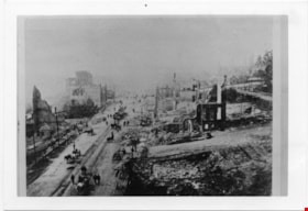
Aftermath of Great Fire of New Westminster, 1898
https://search.heritageburnaby.ca/link/museumdescription4781
- Repository
- Burnaby Village Museum
- Date
- 1898
- Collection/Fonds
- Burnaby Village Museum Photograph collection
- Description Level
- Item
- Physical Description
- 1 photograph : b&w ; 8.8 x 12.7 cm ; copy print
- Scope and Content
- Brick ruins of buildings on either side of a street with people, wagons and horses. Street runs top to bottom on left hand side of photograph.
- Repository
- Burnaby Village Museum
- Collection/Fonds
- Burnaby Village Museum Photograph collection
- Description Level
- Item
- Physical Description
- 1 photograph : b&w ; 8.8 x 12.7 cm ; copy print
- Material Details
- "Columbian files 1971" written on verso in black pen. ""FIRE" NEW WESTMINSTER SEPT. 1898." written on verso in pencil.
- Scope and Content
- Brick ruins of buildings on either side of a street with people, wagons and horses. Street runs top to bottom on left hand side of photograph.
- History
- Part of a set of photographs from the Columbian Newspaper, which operated out of New Westminster under this name starting in 1900 until its dissolution in 1988. Photographs found in the collection of the Burnaby Village are dated 1971.
- Other Title Information
- title based on content and note on verso of photograph
- Accession Code
- BV018.19.7
- Access Restriction
- No restrictions
- Reproduction Restriction
- May be restricted by third party rights
- Date
- 1898
- Media Type
- Photograph
- Scan Resolution
- 600
- Scan Date
- 24-04-2018
Images

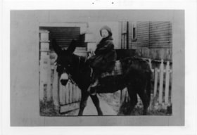
Child on donkey
https://search.heritageburnaby.ca/link/museumdescription4789
- Repository
- Burnaby Village Museum
- Date
- 1890-1900
- Collection/Fonds
- Burnaby Village Museum Photograph collection
- Description Level
- Item
- Physical Description
- 1 photograph : b&w ; 8.9 x 13.8 cm ; copy print
- Scope and Content
- Child mounted on saddled donkey facing left. Child's feet do not reach stirrups. Saddle blanket is plaid. Background includes wooden slatted buildings and picket fence.
- Repository
- Burnaby Village Museum
- Collection/Fonds
- Burnaby Village Museum Photograph collection
- Description Level
- Item
- Physical Description
- 1 photograph : b&w ; 8.9 x 13.8 cm ; copy print
- Material Details
- "Columbian files 1971." written on verso in black pen. "031" stamped on verso.
- Scope and Content
- Child mounted on saddled donkey facing left. Child's feet do not reach stirrups. Saddle blanket is plaid. Background includes wooden slatted buildings and picket fence.
- History
- Part of a set of photographs from the Columbian Newspaper, which operated out of New Westminster under this name starting in 1900 until its dissolution in 1988. Photographs found in the collection of the Burnaby Village are dated 1971.
- Other Title Information
- title based on content of photograph
- Accession Code
- BV018.19.15
- Access Restriction
- No restrictions
- Reproduction Restriction
- May be restricted by third party rights
- Date
- 1890-1900
- Media Type
- Photograph
- Scan Resolution
- 600
- Scan Date
- 24-04-2018
Images

![Douglas Road, [1897] (date of original), copied 1978 thumbnail](/media/hpo/_Data/_BVM_Images/1978/1978_0001_0001_001.jpg?width=280)
Douglas Road
https://search.heritageburnaby.ca/link/museumdescription447
- Repository
- Burnaby Village Museum
- Date
- [1897] (date of original), copied 1978
- Collection/Fonds
- Burnaby Village Museum Photograph collection
- Description Level
- Item
- Physical Description
- 1 photograph : b&w ; 20.2 x 25.2 cm print
- Scope and Content
- Photograph of Douglas Road (later renamed in part Canada Way), near Stanley Street. To the right is the Sprott family property, where a few wooden buildings are visible in the cleared area. Charles Sprott, head of the Sprott family, was an important Burnaby politician who was continuously elected t…
- Repository
- Burnaby Village Museum
- Collection/Fonds
- Burnaby Village Museum Photograph collection
- Description Level
- Item
- Physical Description
- 1 photograph : b&w ; 20.2 x 25.2 cm print
- Scope and Content
- Photograph of Douglas Road (later renamed in part Canada Way), near Stanley Street. To the right is the Sprott family property, where a few wooden buildings are visible in the cleared area. Charles Sprott, head of the Sprott family, was an important Burnaby politician who was continuously elected to serve in the municiality as councillor from 1895 to 1903 and as Reeve from 1904 to 1905.
- Subjects
- Geographic Features - Roads
- Land Clearing
- Geographic Access
- Douglas Road
- Canada Way
- Stanley Street
- Accession Code
- HV978.1.1
- Access Restriction
- No restrictions
- Reproduction Restriction
- No known restrictions
- Date
- [1897] (date of original), copied 1978
- Media Type
- Photograph
- Historic Neighbourhood
- Burnaby Lake (Historic Neighbourhood)
- Planning Study Area
- Lakeview-Mayfield Area
- Scan Resolution
- 600
- Scan Date
- 2023-07-25
- Notes
- Title based on contents of photograph
Images
![Douglas Road, [1897] (date of original), copied 1978 thumbnail](/media/hpo/_Data/_BVM_Images/1978/1978_0001_0001_001.jpg)
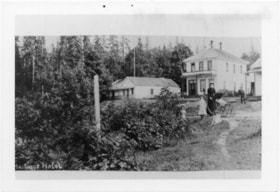
Family group in grounds of Hastings Hotel
https://search.heritageburnaby.ca/link/museumdescription4787
- Repository
- Burnaby Village Museum
- Date
- 1890-1905
- Collection/Fonds
- Burnaby Village Museum Photograph collection
- Description Level
- Item
- Physical Description
- 1 photograph : b&w ; 8.8 x 12.7 cm ; copy print
- Scope and Content
- Shrubs on left and trees in background. On right a woman with 3 children and one infant in pram. On right two and one partial white buildings in background. Two men in background. Writing on bottom left edge.
- Repository
- Burnaby Village Museum
- Collection/Fonds
- Burnaby Village Museum Photograph collection
- Description Level
- Item
- Physical Description
- 1 photograph : b&w ; 8.8 x 12.7 cm ; copy print
- Material Details
- "Columbian files Nov 71" written on verso in black pen. "Hastings Hotel" written in white on front bottom left of photograph.
- Scope and Content
- Shrubs on left and trees in background. On right a woman with 3 children and one infant in pram. On right two and one partial white buildings in background. Two men in background. Writing on bottom left edge.
- History
- Part of a set of photographs from the Columbian Newspaper, which operated out of New Westminster under this name starting in 1900 until its dissolution in 1988. Photographs found in the collection of the Burnaby Village are dated 1971.
- Other Title Information
- title based on note on and content of photograph
- Accession Code
- BV018.19.13
- Access Restriction
- No restrictions
- Reproduction Restriction
- May be restricted by third party rights
- Date
- 1890-1905
- Media Type
- Photograph
- Scan Resolution
- 600
- Scan Date
- 24-04-2018
Images
![Survey and Subdivision plans in New Westminster District Group 1 – Burnaby
, [1861]-[1910] thumbnail](/media/hpo/_Data/_BVM_Cartographic_Material/1977/1977_0093_0019a_001.jpg?width=280)
Survey and Subdivision plans in New Westminster District Group 1 – Burnaby
https://search.heritageburnaby.ca/link/museumdescription6988
- Repository
- Burnaby Village Museum
- Date
- [1861]-[1910]
- Collection/Fonds
- Burnaby Village Museum Map collection
- Description Level
- File
- Physical Description
- 14 plans : 3 plans : black ink on paper hand col. + 7 plans : black ink on paper + 4 plans : graphite on paper mounted on 2 sides of cardboard 76 x 102 cm
- Scope and Content
- Item consists of a large board of four New Westminster District Gp 1 - subdivision plans mounted on one side and ten New Westminster District Gp 1 - subdivision plans mounted on the other side. Side A: 1. "Plan /of / Lots 166A, 166 and 167 /, Gr.1, N.W.D. / Showing Misconstructed Roads in Gree…
- Repository
- Burnaby Village Museum
- Collection/Fonds
- Burnaby Village Museum Map collection
- Description Level
- File
- Physical Description
- 14 plans : 3 plans : black ink on paper hand col. + 7 plans : black ink on paper + 4 plans : graphite on paper mounted on 2 sides of cardboard 76 x 102 cm
- Material Details
- Scales [between 1:2376 and 1:7920]
- Index number on edge of board reads: "19"
- Scope and Content
- Item consists of a large board of four New Westminster District Gp 1 - subdivision plans mounted on one side and ten New Westminster District Gp 1 - subdivision plans mounted on the other side. Side A: 1. "Plan /of / Lots 166A, 166 and 167 /, Gr.1, N.W.D. / Showing Misconstructed Roads in Green / 5 chs = 1 in.". (plan is drawn in black ink and hand coloured in red, green and orange ink). A section in the centre of the plan is coloured in red ink and identified as "C.S. Richmond" running from the North Arm of Fraser River to Wiggins Road and divided by "New Wiggins Rd. (as gazetted)" (coloured in orange ink) and two"Constructed Road(s)" (coloured in green ink). Plan is initialed by: "RB" [sic] (in blue pencil crayon) 2. Plan of / Subdivision of / Lot 166 / Group One / New Westminster District / Scale 4 chs = 1 in. / Map No 524". Plan is drawn in graphite and signed by "Surrig [sic] Welhams [sic] / P.L.S." Plan is initialed by: "RB" [sic] (in blue pencil crayon) 3. Plan of "Survey / of Highway / For / Burnaby Council / in / Lots 13 _14 / Group One / Scale 4 chs = 1 in." Signed by "Albert J. Hill, P.L.S." Caribou Street and Caribou Road run through the centre of the plan. Plan is stamped: "Albert J. Hill, Civil Engineer / and / Provincial Land Surveyor, / New Westminster, / B.C.". Plan is initialed by: "RB" [sic] (in blue pencil crayon) 4. A Plan of Lots 166A, 166 and 167, Group One, New Westminster District (drawn in graphite). A section in the centre of the plan is identified as "C.S. Richmond" running from the North Arm of Fraser River and divided by "New Wiggins Rd. (as gazetted)" and two "Constructed Road(s)". Plan is initialed by: "RB" [sic] (in blue pencil crayon) Side B: 1. Small plan drawn in black ink (no title) identifying lots north of the "North Arm" of the Fraser River. Lots identified include: Lot 99, Lot 98, Lot 157, Lot 158, Lot 163, Lot 162, Lot 159, Lot 163, Lot 162, Lot 165, Lot 166A, Lot 155B, Lot 155A and Lot 159. "Scale 40 chains to one inch" . Plan is initialed by: "RB" [sic] (in blue pencil crayon) (Geographic location: Burnaby) 2. Small plan drawn in black ink (no title) identifying lots north of the North Arm of the Fraser River as "Lots 155, 155A, 155B, 155C, 162, 163, 164, 165, 166A and 167". Plan is initialed by: "RB" [sic] (in blue pencil crayon) (Geographic location: Burnaby) 3. Small plan drawn in black ink (no title) which identifies "Lot 151 / Reserve/ for / Race Course"; "Reserve / 64 A / L. 152 G.1"; and other Lots: 32, 33, 34, 35, 36, 38, 39. The plan is signed "Surveyor G.Turn [sic] July / 61 / from Vol 40 R.L. notes [sic]" Plan is stamped: "Albert J. Hill, Civil Engineer / and / Provincial Land Surveyor, / New Westminster, / B.C." Plan is initialed by: "RB" [sic] (in blue pencil crayon) (Geographic location: Burnaby) 4. Small plan drawn in black in with faded red colouring on centre lot identified as "Lot 34" running north from "Vancouver Road" . Plan is stamped: "Albert J. Hill, Civil Engineer / and / Provincial Land Surveyor, / New Westminster, / B.C." Plan is initialed by: "RB" [sic] (in blue pencil crayon) (Geographic location: Burnaby) 5. Plan drawn in graphite and identified as "Lot 98, Gr.1," along with the intials "RB" [sic] (both are handwritten in blue crayon pencil on top of plan) The B.C.E.Railway is identified running through the plan along with Jubilee Road and Royal Oak Road. The plan is signed with the name "Wm. Murray" and the Plan is stamped: "Albert J. Hill, Civil Engineer / and / Provincial Land Surveyor, / New Westminster, / B.C.". (Geographic location: Burnaby) 6. Plan drawn in graphite identified as "Port Lot 13, Gr.1" along with the intials "RB" [sic] (both are handwritten in blue crayon pencil on top of plan) Plan is stamped: "Albert J. Hill, Civil Engineer / and / Provincial Land Surveyor, / New Westminster, / B.C.". (Geographic location: Burnaby) 7.Plan drawn in black ink and identified as "Lot 98 G.1" along with the intials "RB" [sic] (both are handwritten in blue crayon pencil on top of plan). A "Road Reservation" is identified running north between "Electric Tramway" and connecting with "Royal Oak Road". Plan is stamped: "Albert J. Hill, Civil Engineer / and / Provincial Land Surveyor, / New Westminster, / B.C." (Geographic location: Burnaby) 8. Plan drawn in black ink and divided into two sections, the upper plan is identified as "Portion / Lots 100 / area / 101, Gr.1" and the lower plan is identified as "Portion L. 3 G. 1" along with the intials "RB" [sic] (these identifiers are handwritten in blue crayon pencil on top of the plan). Portions of Lot 100 and Lot 101 are each divided into 6 sections and the Portion of Lot 3 plan is divided into 24 sections. The plan includes a note in black ink that reads: " Received from Wm Fromme [sic] / from Wm. Trapp / Nov. 28, 1895 / A. J. T...[sic]". (Geographic location: Burnaby) 9. Plan drawn in black ink (no title) identifying soil, buildings and geographic features in southern Burnaby. The plan is bordered by "New Westminster City" (Tenth Avenue and DL 172) to the south east and DL 173 to the south, DL 158 to the west and the B.C.E. Tramway to the north. Plan includes District Lots: 155A, 158, 159, 171, 160, 53 and 95 and identifies soil, marshland and ravines throughout. Plan identifies the following features: a "Team Road" running through Lots 158 and 159 along with "Fair Orchard Soil / Even Surface Throughout / No Ravines", "Gravel and Shingle" (bottom of Lot 158), "North Arm Road" crossing "Byrne Road" and connecting with "Power House Road" which runs north to connect with "Highland Park Station" and the B.C.E. Tramway, "Power Ho" in the northeast corner of DL 160, a "Brook" connected with a "Deep Ravine" running between DL 53, DL 95 and DL 160 along with "Good Soil" and "Fair Orchard Soil" identified nearby in DL 95. Scale is identified as "10 chs = 1 in." Plan is stamped: "Albert J. Hill, Civil Engineer / and / Provincial Land Surveyor, / New Westminster, / B.C." Plan is initialed by: "RB" [sic] (in blue pencil crayon) (Geographic location: Burnaby) 10. Plan drawn in black ink (no title) with Burnaby Lake and Deer Lake at the centre. The plan is bordered by the following District Lots identified as: 117, 118 and 68 to the west, Lots 80, 79 and 85 to the southwest, Lots 11, 13, and 1 (City of New Westminster) to the south east, the North Road boundary to the east and Lots 8, 56, 57, 59, and 136 to the North. The lower right hand corner of the plan has a small inset which reads: "Burnaby Lake" and "Page 19 R.B. Notes". Plan is initialed by: "RB" [sic] (in blue pencil crayon) (Geographic location: Burnaby)
- Creator
- Hill, Albert James
- Accession Code
- HV977.93.19
- Access Restriction
- No restrictions
- Reproduction Restriction
- No known restrictions
- Date
- [1861]-[1910]
- Media Type
- Cartographic Material
- Scan Resolution
- 300
- Scale
- 72
- Notes
- Title based on contents of file
- Scale is measured in chains. (One chain equals 792 inches)
- The term "Lot" can also refer to a "District Lot”
- Some plans are stamped: "Albert J. Hill, Civil Engineer / and / Provincial Land Surveyor, / New Westminster, / B.C." and intialed: "RB" [sic]
Images
![Survey and Subdivision plans in New Westminster District Group 1 – Burnaby
, [1861]-[1910] thumbnail](/media/hpo/_Data/_BVM_Cartographic_Material/1977/1977_0093_0019a_001.jpg)

![Central Park siding of Westminster and Vancouver Tramway Co., [between 1891 and 1894] thumbnail](/media/hpo/_Data/_BVM_Images/2021/2021_0029_0001_001.jpg?width=280)
Central Park siding of Westminster and Vancouver Tramway Co.
https://search.heritageburnaby.ca/link/museumdescription17430
- Repository
- Burnaby Village Museum
- Date
- [between 1891 and 1894]
- Collection/Fonds
- Burnaby Village Museum Photograph collection
- Description Level
- Item
- Physical Description
- 1 photograph : b&w albumen print on card ; 20 x 25 cm
- Scope and Content
- Photograph of two streetcars at the Central Park siding of Westminster and Vancouver Tramway Co. Conductors, engineers and riders are posing with the streetcars. The fronts of the streetcars include painted signage reading "12" and "13" and the sides of the streetcars read "WESTMINSTER AND VANCOUVE…
- Repository
- Burnaby Village Museum
- Collection/Fonds
- Burnaby Village Museum Photograph collection
- Description Level
- Item
- Physical Description
- 1 photograph : b&w albumen print on card ; 20 x 25 cm
- Scope and Content
- Photograph of two streetcars at the Central Park siding of Westminster and Vancouver Tramway Co. Conductors, engineers and riders are posing with the streetcars. The fronts of the streetcars include painted signage reading "12" and "13" and the sides of the streetcars read "WESTMINSTER AND VANCOUVER TRAMWAY CO. LTD.".
- History
- Photographers Richard H. Trueman and Norman Caple operated out of Vancouver between 1891 and 1894. The photographers worked between Winnipeg and the west coast of Canada specializing in mountain and railway views, ranch scenes and Indigenous peoples. In 1890, two companies started building electric rail; the Westminster and Vancouver Tramway Co., which undertook the ambitious project of building the first real interurban line from New Westminster to Vancouver, and the Westminster Street Railway. By April 20, 1891, both companies merged to form the Westminster and Vancouver Tramway Company. Streetcar service began in June 1891, travelling on twelve miles of track between New Westminster and eastern Vancouver and running through Burnaby. The line was taken over by the B.C. Electric Railway Company in 1897 until the line was closed in October 1953.
- Accession Code
- BV021.29.1
- Access Restriction
- No restrictions
- Reproduction Restriction
- No known restrictions
- Date
- [between 1891 and 1894]
- Media Type
- Photograph
- Historic Neighbourhood
- Central Park (Historic Neighbourhood)
- Planning Study Area
- Maywood Area
- Scan Resolution
- 600
- Scan Date
- 2021-09-24
- Scale
- 100
- Photographer
- Trueman & Caple
- Notes
- Title taken from recto of photograph
- Inscription on recto of photograph reads: "1138_Central Parkk Sideing of Westminster and Vancouver Tramway Co. _Trueman and Caple. Photo. Vancouver B.C."
- Inscription in gold ink on board reads: "Trueman & Caple_Vancouver, B.C."
Images
![Central Park siding of Westminster and Vancouver Tramway Co., [between 1891 and 1894] thumbnail](/media/hpo/_Data/_BVM_Images/2021/2021_0029_0001_001.jpg)
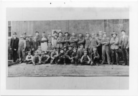
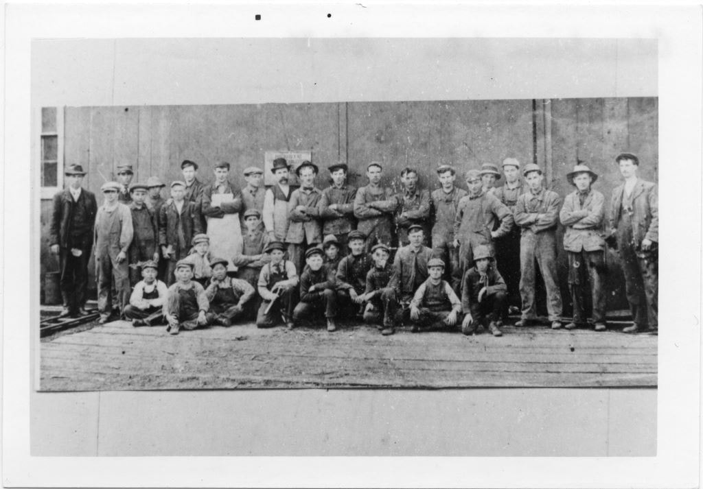
Group portrait of 34 men and boys
https://search.heritageburnaby.ca/link/museumdescription4788
- Repository
- Burnaby Village Museum
- Date
- 1890-1900
- Collection/Fonds
- Burnaby Village Museum Photograph collection
- Description Level
- Item
- Physical Description
- 1 photograph : b&w ; 8.9 x 13.8 cm ; copy print
- Scope and Content
- Group portrait of 34 men and boys in front of a wooden building. 21 standing in back row. 13 kneeling or crouching in front row. One man standing on far left is wearing a suit and tie, all others are wearing overalls, some with aprons.
- Repository
- Burnaby Village Museum
- Collection/Fonds
- Burnaby Village Museum Photograph collection
- Description Level
- Item
- Physical Description
- 1 photograph : b&w ; 8.9 x 13.8 cm ; copy print
- Material Details
- "Columbian files Nov 71" written on verso in black pen.
- Scope and Content
- Group portrait of 34 men and boys in front of a wooden building. 21 standing in back row. 13 kneeling or crouching in front row. One man standing on far left is wearing a suit and tie, all others are wearing overalls, some with aprons.
- History
- Part of a set of photographs from the Columbian Newspaper, which operated out of New Westminster under this name starting in 1900 until its dissolution in 1988. Photographs found in the collection of the Burnaby Village are dated 1971.
- Other Title Information
- title based on content of photograph
- Accession Code
- BV018.19.14
- Access Restriction
- No restrictions
- Reproduction Restriction
- May be restricted by third party rights
- Date
- 1890-1900
- Media Type
- Photograph
- Scan Resolution
- 600
- Scan Date
- 24-04-2018
Images
![Powerhouse, [189-?] (date of original), copied [196-?] thumbnail](/media/hpo/_Data/_BVM_Images/1976/1976_0145_0002_001.jpg?width=280)
Powerhouse
https://search.heritageburnaby.ca/link/museumdescription831
- Repository
- Burnaby Village Museum
- Date
- [189-?] (date of original), copied [196-?]
- Collection/Fonds
- Burnaby Village Museum Photograph collection
- Description Level
- Item
- Physical Description
- 1 photograph : b&w ; 7.6 x 9.6 cm print
- Scope and Content
- Photograph of a powerhouse with tall smoke stacks, located beside railway tracks. Three trams can be seen on the right side of the photograph and men are standing outside of the building. According to an accompanying note, the powerhouse doubled as a steam plant and a car barn. Constructed in 1891,…
- Repository
- Burnaby Village Museum
- Collection/Fonds
- Burnaby Village Museum Photograph collection
- Description Level
- Item
- Physical Description
- 1 photograph : b&w ; 7.6 x 9.6 cm print
- Scope and Content
- Photograph of a powerhouse with tall smoke stacks, located beside railway tracks. Three trams can be seen on the right side of the photograph and men are standing outside of the building. According to an accompanying note, the powerhouse doubled as a steam plant and a car barn. Constructed in 1891, it was between Edmonds and Highland Park on the Central Park Interurban Line. The steam plant provided power to run the line, then operated by Westminster and Vancouver Tramway Company.
- Subjects
- Transportation - Electric Railroads
- Accession Code
- HV976.145.2
- Access Restriction
- No restrictions
- Reproduction Restriction
- May be restricted by third party rights
- Date
- [189-?] (date of original), copied [196-?]
- Media Type
- Photograph
- Historic Neighbourhood
- Edmonds (Historic Neighbourhood)
- Planning Study Area
- Stride Avenue Area
- Scan Resolution
- 600
- Scan Date
- 2023-06-27
- Notes
- Title based on contents of photograph
Images
![Powerhouse, [189-?] (date of original), copied [196-?] thumbnail](/media/hpo/_Data/_BVM_Images/1976/1976_0145_0002_001.jpg)
![Sarah Gillon Dale, [189-] (date of original), copied 1978 thumbnail](/media/hpo/_Data/_BVM_Images/1977/197900320011.jpg?width=280)
Sarah Gillon Dale
https://search.heritageburnaby.ca/link/museumdescription1785
- Repository
- Burnaby Village Museum
- Date
- [189-] (date of original), copied 1978
- Collection/Fonds
- E.W. Bateman family fonds
- Description Level
- Item
- Physical Description
- 1 photograph : b&w ; 12.8 x 8.9 cm print
- Scope and Content
- Photograph of Sarah Gillon Dale with a scarf or hat over her white hair. She has ruffled scarves around her neck. There is a brick building behind her. The inscription and the accession register identify the woman as the wife of Mr. George Dale and the mother of Catherine Dale Bateman.
- Repository
- Burnaby Village Museum
- Collection/Fonds
- E.W. Bateman family fonds
- Description Level
- Item
- Physical Description
- 1 photograph : b&w ; 12.8 x 8.9 cm print
- Scope and Content
- Photograph of Sarah Gillon Dale with a scarf or hat over her white hair. She has ruffled scarves around her neck. There is a brick building behind her. The inscription and the accession register identify the woman as the wife of Mr. George Dale and the mother of Catherine Dale Bateman.
- History
- Mrs. Dale was born Sarah Gillon.
- Names
- Dale, Sarah Gillon
- Accession Code
- HV979.32.11
- Access Restriction
- No restrictions
- Reproduction Restriction
- No known restrictions
- Date
- [189-] (date of original), copied 1978
- Media Type
- Photograph
- Scan Resolution
- 600
- Scan Date
- 2023-09-05
- Notes
- Title based on contents of photograph
- The annotation on the back of the photo reads: "Mrs. E.W. Bateman's mother. / Mrs. Dale."
Images
![Sarah Gillon Dale, [189-] (date of original), copied 1978 thumbnail](/media/hpo/_Data/_BVM_Images/1977/197900320011.jpg)