Narrow Results By
Decade
- 2020s 153
- 2010s 212
- 2000s
- 1990s 654
- 1980s
- 1970s 1013
- 1960s 315
- 1950s 395
- 1940s 584
- 1930s 546
- 1920s 478
- 1910s 479
- 1900s 405
- 1890s 117
- 1880s 26
- 1870s 14
- 1860s 12
- 1850s 5
- 1840s 3
- 1830s 3
- 1820s 3
- 1810s 3
- 1800s 3
- 1790s 3
- 1780s 3
- 1770s 3
- 1760s 3
- 1750s 3
- 1740s 3
- 1730s 3
- 1720s 3
- 1710s 3
- 1700s
- 1690s 3
- 1680s 3
- 1670s 3
- 1660s 3
- 1650s 3
- 1640s 3
- 1630s 3
- 1620s 3
- 1610s 3
- 1600s 3
- 1520s 1
Millway family subseries
https://search.heritageburnaby.ca/link/archivedescription66632
- Repository
- City of Burnaby Archives
- Date
- 1898-1986
- Collection/Fonds
- Burnaby Historical Society fonds
- Description Level
- Subseries
- Physical Description
- Textual records and 1 photograph
- Scope and Content
- Subseries consists of material created and collected by Reginald and Betty Millway, including a map of the Municipal of Burnaby and research on Robert Burnaby.
- Repository
- City of Burnaby Archives
- Date
- 1898-1986
- Collection/Fonds
- Burnaby Historical Society fonds
- Subseries
- Millway family subseries
- Physical Description
- Textual records and 1 photograph
- Description Level
- Subseries
- Accession Number
- BHS1997-12
- BHS1999-11
- Scope and Content
- Subseries consists of material created and collected by Reginald and Betty Millway, including a map of the Municipal of Burnaby and research on Robert Burnaby.
- History
- Reginald E. "Reg" Millway was born on December 20, 1915 at Milton Regis in the County of Kent. He graduated from London University via Regent Street Polytechnic and was appointed to the Air Ministry Technical Division in 1937, where he remained throughout World War II. Due to a hearing impairment he was unable to join the services and instead joined the Home Guard and served on fire bomb patrol in central London. Betty was born November 16, 1916. She married Reginald in 1940. Together they had four daughters: Catherine, Penelope “Penny”, Jennifer and Francis “Fran”. The Millways left Britain in March 1948. They sailed on the last voyage of the Acquitania to Halifax, and then took a parlour car in a C.N. train to New Westminster and took up residence in South Burnaby. After two or three years, Reginald had established his own business, Marine Electronics. When the United Flower Growers Cooperative formed in the late 1950s, Reginald helped them assemble property at Roseberry and Marine Way in cooperation with the Director of Planning. A large auditorium was built there and Reginald helped them design, manufacture and install a complete electronic system. Modifications and additions have occurred along the way to the point that it is handling millions of dollars worth of flowers annually and it is the largest operation of its kind in Canada. Reginald Millway ran in the Burnaby elections of 1957. Newly elected Mayor Alan Emmot offered him the chairmanship of the Zoning Board of Appeal (later the Board of Variance). He remained chairman for the next 35 years. In 1962, he joined the Rotary Club of Burnaby; he served as president of the club in 1969 and was a member for over 45 years. Reginald was also an early member of the Burnaby Historical Society. He served as its president for three terms. He and Blythe Eagles went to Loughborough, England, on behalf of the Society to locate and clean up the site of Robert Burnaby's grave. Reginald was also on the committee that acquired the property and organised the establishment of the Burnaby Village Museum. Betty Millway was an accomplished writer and received the 1984 Canadian Author’s Association Allan Sagster Award for long and meritorious service. She developed Robert Burnaby's family tree for the Historical Society and in the process made many contacts with prominent citizens of Loughborough, including the executive controller of the area, who introduced the Millways to the Mayor and Council. This formed the groundwork for a close relationship which Mayor Bill Lewarne formerly developed as a Sister City relationship in 1985. The Millways were longstanding members of the Burnaby Beautification Committee and their garden was featured in Gardens West in the 1998 November/December issue. Betty Millway died July 21, 2005. Reginald E. Millway died November 7, 2010.
- Media Type
- Photograph
- Textual Record
- Notes
- Title based on contents of subseries
- PC353, MSS157
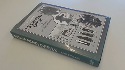
Mourning dress : a costume and social history
https://search.heritageburnaby.ca/link/museumlibrary872
- Repository
- Burnaby Village Museum
- Collection
- Reference Collection
- Material Type
- Book
- ISBN
- 0047460164
- Call Number
- 391.8 TAY
- Author
- Taylor, Lou
- Place of Publication
- London
- Publisher
- Allen & Unwin
- Publication Date
- c1983
- Physical Description
- 327 p. : ill. ; 24 cm.
- Inscription
- "Curators Office / Burnaby Village Museum", handwritten in pencil on cover page.
- Library Subject (LOC)
- Costume--Europe--History
- Costume--United States--History
- Mourning etiquette--Europe--History
- Mourning etiquette--United States--History
- Notes
- Includes bibliographical references (p. 322-323) and index.
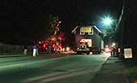
Moving the Love farmhouse
https://search.heritageburnaby.ca/link/museumdescription11039
- Repository
- Burnaby Village Museum
- Date
- May 20, 1988
- Collection/Fonds
- Burnaby Village Museum fonds
- Description Level
- Item
- Physical Description
- 1 photograph : col. negative ; 35 mm
- Scope and Content
- Night view of the Love farmhouse on a truck being transported by the Nikel Brother's Moving Company. Aerial trucks are travelling alongside of the house to lift the overhead wires.
- Repository
- Burnaby Village Museum
- Collection/Fonds
- Burnaby Village Museum fonds
- Series
- Jesse Love farmhouse series
- Description Level
- Item
- Physical Description
- 1 photograph : col. negative ; 35 mm
- Material Details
- Photograph is part of Film roll "35-53" - 25 colour negatives and 18 colour photographs that are a part of a collection described as BV018.41.82
- Scope and Content
- Night view of the Love farmhouse on a truck being transported by the Nikel Brother's Moving Company. Aerial trucks are travelling alongside of the house to lift the overhead wires.
- Subjects
- Buildings - Heritage
- Geographic Access
- Cumberland Street
- Street Address
- 7651 Cumberland Street
- Accession Code
- BV018.41.507
- Access Restriction
- No restrictions
- Reproduction Restriction
- No known restrictions
- Date
- May 20, 1988
- Media Type
- Photograph
- Historic Neighbourhood
- East Burnaby (Historic Neighbourhood)
- Planning Study Area
- Cariboo-Armstrong Area
- Related Material
- See BV018.41.82 for File Level Description
- Scan Resolution
- 2400
- Scan Date
- 8-Jul-19
- Scale
- 100
- Photographer
- Wolf, Jim
- Notes
- Title based on contents of photograph
- Photograph is a part of file level description "Photographic documentation of changes and move" BV018.41.82
Images

Moving the Love farmhouse
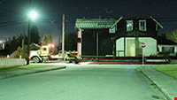
https://search.heritageburnaby.ca/link/museumdescription11040
- Repository
- Burnaby Village Museum
- Date
- May 20, 1988
- Collection/Fonds
- Burnaby Village Museum fonds
- Description Level
- Item
- Physical Description
- 1 photograph : col. negative ; 35 mm
- Scope and Content
- Night view of the Love farmhouse on a truck being transported along Cumberland Street by the Nikel Brother's Moving Company.
- Repository
- Burnaby Village Museum
- Collection/Fonds
- Burnaby Village Museum fonds
- Series
- Jesse Love farmhouse series
- Description Level
- Item
- Physical Description
- 1 photograph : col. negative ; 35 mm
- Material Details
- Photograph is part of Film roll "35-53" - 25 colour negatives and 18 colour photographs that are a part of a collection described as BV018.41.82
- Scope and Content
- Night view of the Love farmhouse on a truck being transported along Cumberland Street by the Nikel Brother's Moving Company.
- Subjects
- Buildings - Heritage
- Geographic Access
- Cumberland Street
- Street Address
- 7651 Cumberland Street
- Accession Code
- BV018.41.510
- Access Restriction
- No restrictions
- Reproduction Restriction
- No known restrictions
- Date
- May 20, 1988
- Media Type
- Photograph
- Historic Neighbourhood
- East Burnaby (Historic Neighbourhood)
- Planning Study Area
- Cariboo-Armstrong Area
- Related Material
- See BV018.41.82 for File Level Description
- Scan Resolution
- 2400
- Scan Date
- 8-Jul-19
- Scale
- 100
- Photographer
- Wolf, Jim
- Notes
- Title based on contents of photograph
- Photograph is a part of file level description "Photographic documentation of changes and move" BV018.41.82
Images
Mrs. James Richard (Dick) Whiting
https://search.heritageburnaby.ca/link/museumdescription9848
- Repository
- Burnaby Village Museum
- Date
- [1947] (date of original)-[1998]
- Collection/Fonds
- Burnaby Village Museum fonds
- Description Level
- File
- Physical Description
- 2 cm of textual records
- Scope and Content
- File consists of copies of biographical and genealogical information and photocopies of photographs along with interview notes (November 6, 1997). File also includes a newspaper clipping "She was Named for the Municipality / Burnaby's first baby visiting from England" about Mrs. C.A. Whiting who wa…
- Repository
- Burnaby Village Museum
- Collection/Fonds
- Burnaby Village Museum fonds
- Series
- Jesse Love farmhouse series
- Subseries
- Love farmhouse research files subseries
- Description Level
- File
- Physical Description
- 2 cm of textual records
- Scope and Content
- File consists of copies of biographical and genealogical information and photocopies of photographs along with interview notes (November 6, 1997). File also includes a newspaper clipping "She was Named for the Municipality / Burnaby's first baby visiting from England" about Mrs. C.A. Whiting who was the first white baby born in Burnaby ca. 1893. File includes information obtained from Florence Edna Whiting (Mrs. James Richard Whiting) who is the daughter in law of Annie (Love) Whiting and Wallace Whiting. Mrs. James Richard Whiting married Richard Whiting.
- Accession Code
- BV018.41.59
- Access Restriction
- Subject to FIPPA
- Reproduction Restriction
- Reproductions subject to FIPPA
- Date
- [1947] (date of original)-[1998]
- Media Type
- Textual Record
- Notes
- Transcribed title
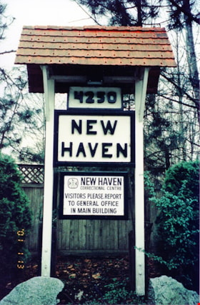
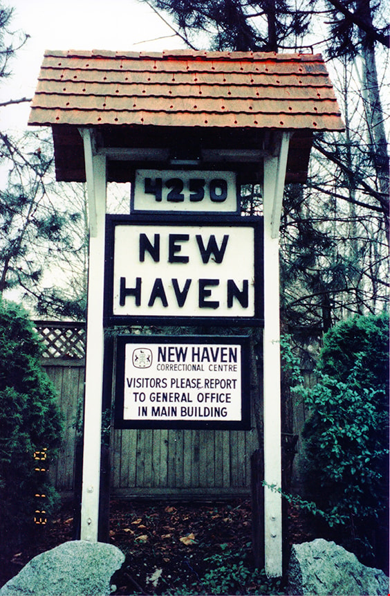
New Haven
https://search.heritageburnaby.ca/link/museumdescription13525
- Repository
- Burnaby Village Museum
- Date
- Jan. 2001
- Collection/Fonds
- Burnaby Village Museum Photograph collection
- Description Level
- Item
- Physical Description
- 1 photograph : col. ; 5.3 x 10 cm
- Scope and Content
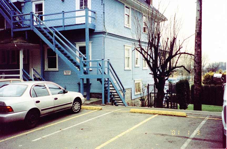
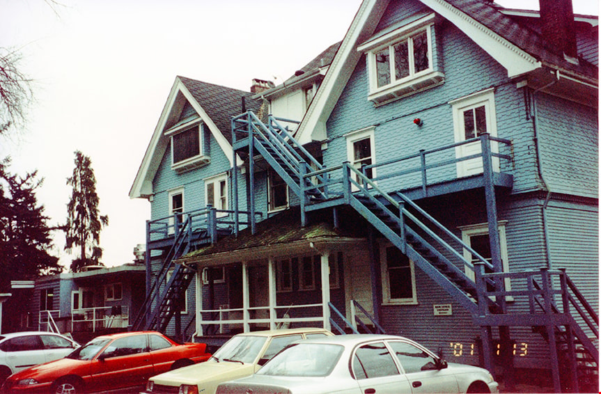
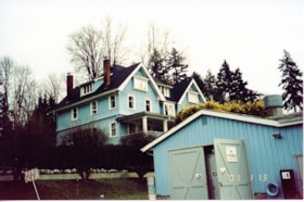
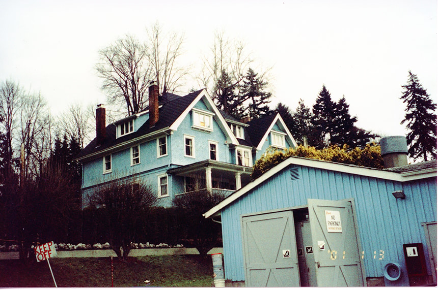
- Photograph of signage outside of New Haven Correctional Centre. Signage reads, "4250 / NEW HAVEN / NEW HAVEN / CORRECTIONAL CENTRE / VISITORS PLEASE REPORT / TO GENERAL OFFICE / IN MAIN BUILDING".
- Repository
- Burnaby Village Museum
- Collection/Fonds
- Burnaby Village Museum Photograph collection
- Description Level
- Item
- Physical Description
- 1 photograph : col. ; 5.3 x 10 cm
- Scope and Content
- Photograph of signage outside of New Haven Correctional Centre. Signage reads, "4250 / NEW HAVEN / NEW HAVEN / CORRECTIONAL CENTRE / VISITORS PLEASE REPORT / TO GENERAL OFFICE / IN MAIN BUILDING".
- History
- In 1937 New Haven Correctional Centre was established as the British Columbia Training School on the southeast side of Marine Drive in Burnaby (4250 Marine Drive). Sections of Sussex and Patterson Avenues bordered the estate. Originally, the facility housed nineteen inmates with two staff and was one of the first initiatives in Canada to segregate young adult inmates into a separate institution apart from adults. This was part of the Borstal system that started in England whereby young male offenders between the ages of sixteen and twenty one were trained to earn an honest living. Alterations and additions to the estate took place between December 1937 and October 1939 so that more inmates could be accomodated. Five new cottages were built that could hold up to forty people. Except for the plastering and lighting, all work on the new cottages was done by the inmates. On October 29, 1939, the Lieutenant-Governor Eric Hamber formally opened the New Haven Borstal School. World War II interrupted full development of the intstitution and it was closed in 1941 when the inmates were were conscripted into the army. Between 1941 and 1947 the Deaf and Blind Institute were housed at New Haven. In 1947, the New Haven Borstal School returned to the estate. New additions were added to old buildings and new additional buildings were erected on the site over the years including a warden's house on the east grounds and a barn and gymnasium. In the 1970s an equipment shed was added along with another dormitory and a variety of small sheds and storage buildings. The correctional centre officially closed in March 2001.
- Subjects
- Public Services - Correctional
- Geographic Access
- Marine Drive
- Street Address
- 4250 Marine Drive
- Accession Code
- BV020.5.869
- Access Restriction
- No restrictions
- Reproduction Restriction
- No known restrictions
- Date
- Jan. 2001
- Media Type
- Photograph
- Historic Neighbourhood
- Fraser Arm (Historic Neighbourhood)
- Planning Study Area
- Suncrest Area
- Scan Resolution
- 600
- Scan Date
- 25-Aug-2020
- Scale
- 100
- Notes
- Title based on contents of photograph
- Photograph processing stamp on front of photograph reads: "'01_1_13"
- Historical information based on notes from Mary Forsyth's research notes "New Haven" MSS185-018
Images
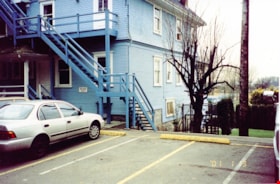
New Haven building and parking lot
https://search.heritageburnaby.ca/link/museumdescription13528
- Repository
- Burnaby Village Museum
- Date
- Jan. 2001
- Collection/Fonds
- Burnaby Village Museum Photograph collection
- Description Level
- Item
- Physical Description
- 1 photograph : col. ; 5.3 x 10 cm
- Scope and Content
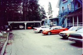
- Photograph of the main building and parking lot of New Haven Correctional Centre located on Marine Drive in Burnaby.
- Repository
- Burnaby Village Museum
- Collection/Fonds
- Burnaby Village Museum Photograph collection
- Description Level
- Item
- Physical Description
- 1 photograph : col. ; 5.3 x 10 cm
- Scope and Content
- Photograph of the main building and parking lot of New Haven Correctional Centre located on Marine Drive in Burnaby.
- History
- In 1937 New Haven Correctional Centre was established as the British Columbia Training School on the southeast side of Marine Drive in Burnaby (4250 Marine Drive). Sections of Sussex and Patterson Avenues bordered the estate. Originally, the facility housed nineteen inmates with two staff and was one of the first initiatives in Canada to segregate young adult inmates into a separate institution apart from adults. This was part of the Borstal system that started in England whereby young male offenders between the ages of sixteen and twenty one were trained to earn an honest living. Alterations and additions to the estate took place between December 1937 and October 1939 so that more inmates could be accomodated. Five new cottages were built that could hold up to forty people. Except for the plastering and lighting, all work on the new cottages was done by the inmates. On October 29, 1939, the Lieutenant-Governor Eric Hamber formally opened the New Haven Borstal School. World War II interrupted full development of the intstitution and it was closed in 1941 when the inmates were were conscripted into the army. Between 1941 and 1947 the Deaf and Blind Institute were housed at New Haven. In 1947, the New Haven Borstal School returned to the estate. New additions were added to old buildings and new additional buildings were erected on the site over the years including a warden's house on the east grounds and a barn and gymnasium. In the 1970s an equipment shed was added along with another dormitory and a variety of small sheds and storage buildings. The correctional centre officially closed in March 2001.
- Subjects
- Public Services - Correctional
- Geographic Access
- Marine Drive
- Street Address
- 4250 Marine Drive
- Accession Code
- BV020.5.872
- Access Restriction
- No restrictions
- Reproduction Restriction
- No known restrictions
- Date
- Jan. 2001
- Media Type
- Photograph
- Historic Neighbourhood
- Fraser Arm (Historic Neighbourhood)
- Planning Study Area
- Suncrest Area
- Scan Resolution
- 600
- Scan Date
- 25-Aug-2020
- Scale
- 100
- Notes
- Title based on contents of photograph
- Photograph processing stamp on front of photograph reads: "'01_1_13"
- Historical information based on notes from Mary Forsyth's research notes "New Haven" MSS185-018
Images
New Haven building and parking lot
https://search.heritageburnaby.ca/link/museumdescription13529
- Repository
- Burnaby Village Museum
- Date
- Jan. 2001
- Collection/Fonds
- Burnaby Village Museum Photograph collection
- Description Level
- Item
- Physical Description
- 1 photograph : col. ; 5.3 x 10 cm
- Scope and Content
- Photograph of the main building and parking lot of New Haven Correctional Centre located on Marine Drive in Burnaby.
- Repository
- Burnaby Village Museum
- Collection/Fonds
- Burnaby Village Museum Photograph collection
- Description Level
- Item
- Physical Description
- 1 photograph : col. ; 5.3 x 10 cm
- Scope and Content
- Photograph of the main building and parking lot of New Haven Correctional Centre located on Marine Drive in Burnaby.
- History
- In 1937 New Haven Correctional Centre was established as the British Columbia Training School on the southeast side of Marine Drive in Burnaby (4250 Marine Drive). Sections of Sussex and Patterson Avenues bordered the estate. Originally, the facility housed nineteen inmates with two staff and was one of the first initiatives in Canada to segregate young adult inmates into a separate institution apart from adults. This was part of the Borstal system that started in England whereby young male offenders between the ages of sixteen and twenty one were trained to earn an honest living. Alterations and additions to the estate took place between December 1937 and October 1939 so that more inmates could be accomodated. Five new cottages were built that could hold up to forty people. Except for the plastering and lighting, all work on the new cottages was done by the inmates. On October 29, 1939, the Lieutenant-Governor Eric Hamber formally opened the New Haven Borstal School. World War II interrupted full development of the intstitution and it was closed in 1941 when the inmates were were conscripted into the army. Between 1941 and 1947 the Deaf and Blind Institute were housed at New Haven. In 1947, the New Haven Borstal School returned to the estate. New additions were added to old buildings and new additional buildings were erected on the site over the years including a warden's house on the east grounds and a barn and gymnasium. In the 1970s an equipment shed was added along with another dormitory and a variety of small sheds and storage buildings. The correctional centre officially closed in March 2001.
- Subjects
- Public Services - Correctional
- Geographic Access
- Marine Drive
- Street Address
- 4250 Marine Drive
- Accession Code
- BV020.5.873
- Access Restriction
- No restrictions
- Reproduction Restriction
- No known restrictions
- Date
- Jan. 2001
- Media Type
- Photograph
- Historic Neighbourhood
- Fraser Arm (Historic Neighbourhood)
- Planning Study Area
- Suncrest Area
- Scan Resolution
- 600
- Scan Date
- 25-Aug-2020
- Scale
- 100
- Notes
- Title based on contents of photograph
- Photograph processing stamp on front of photograph reads: "'01_1_13"
- Historical information based on notes from Mary Forsyth's research notes "New Haven" MSS185-018
Images
New Haven building and parking lot
https://search.heritageburnaby.ca/link/museumdescription13530
- Repository
- Burnaby Village Museum
- Date
- Jan. 2001
- Collection/Fonds
- Burnaby Village Museum Photograph collection
- Description Level
- Item
- Physical Description
- 1 photograph : col. ; 5.3 x 10 cm
- Scope and Content
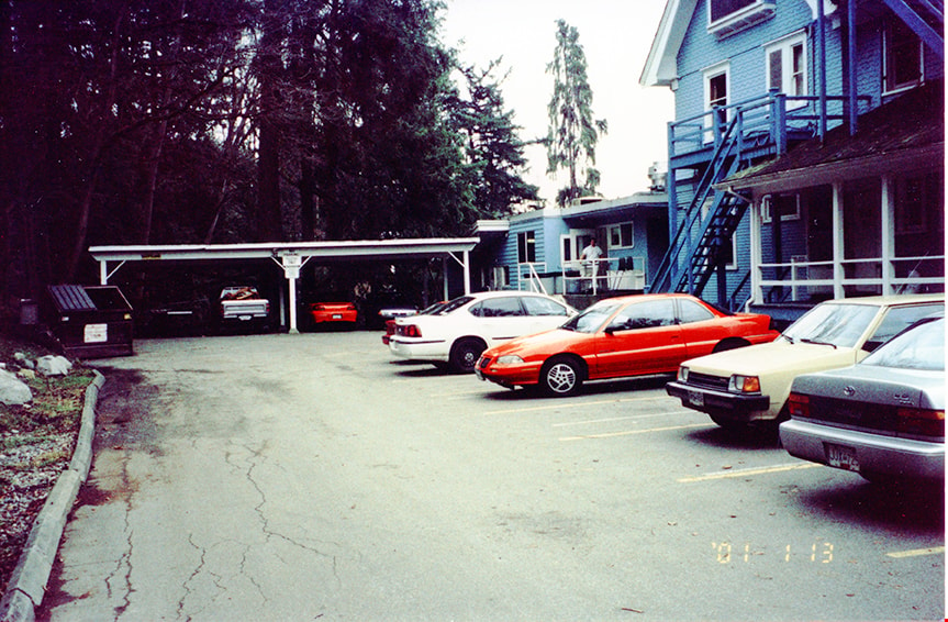
- Photograph of the main building and cars in parking lot of New Haven Correctional Centre located on Marine Drive in Burnaby.
- Repository
- Burnaby Village Museum
- Collection/Fonds
- Burnaby Village Museum Photograph collection
- Description Level
- Item
- Physical Description
- 1 photograph : col. ; 5.3 x 10 cm
- Scope and Content
- Photograph of the main building and cars in parking lot of New Haven Correctional Centre located on Marine Drive in Burnaby.
- History
- In 1937 New Haven Correctional Centre was established as the British Columbia Training School on the southeast side of Marine Drive in Burnaby (4250 Marine Drive). Sections of Sussex and Patterson Avenues bordered the estate. Originally, the facility housed nineteen inmates with two staff and was one of the first initiatives in Canada to segregate young adult inmates into a separate institution apart from adults. This was part of the Borstal system that started in England whereby young male offenders between the ages of sixteen and twenty one were trained to earn an honest living. Alterations and additions to the estate took place between December 1937 and October 1939 so that more inmates could be accomodated. Five new cottages were built that could hold up to forty people. Except for the plastering and lighting, all work on the new cottages was done by the inmates. On October 29, 1939, the Lieutenant-Governor Eric Hamber formally opened the New Haven Borstal School. World War II interrupted full development of the intstitution and it was closed in 1941 when the inmates were were conscripted into the army. Between 1941 and 1947 the Deaf and Blind Institute were housed at New Haven. In 1947, the New Haven Borstal School returned to the estate. New additions were added to old buildings and new additional buildings were erected on the site over the years including a warden's house on the east grounds and a barn and gymnasium. In the 1970s an equipment shed was added along with another dormitory and a variety of small sheds and storage buildings. The correctional centre officially closed in March 2001.
- Subjects
- Public Services - Correctional
- Geographic Access
- Marine Drive
- Street Address
- 4250 Marine Drive
- Accession Code
- BV020.5.874
- Access Restriction
- No restrictions
- Reproduction Restriction
- No known restrictions
- Date
- Jan. 2001
- Media Type
- Photograph
- Historic Neighbourhood
- Fraser Arm (Historic Neighbourhood)
- Planning Study Area
- Suncrest Area
- Scan Resolution
- 600
- Scan Date
- 25-Aug-2020
- Scale
- 100
- Notes
- Title based on contents of photograph
- Photograph processing stamp on front of photograph reads: "'01_1_13"
- Historical information based on notes from Mary Forsyth's research notes "New Haven" MSS185-018
Images
New Haven buildings
https://search.heritageburnaby.ca/link/museumdescription13527
- Repository
- Burnaby Village Museum
- Date
- Jan. 2001
- Collection/Fonds
- Burnaby Village Museum Photograph collection
- Description Level
- Item
- Physical Description
- 1 photograph : col. ; 5.3 x 10 cm
- Scope and Content
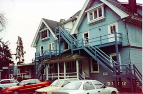
- Photograph of the main building and workshop building inside of New Haven Correctional Centre located on Marine Drive in Burnaby.
- Repository
- Burnaby Village Museum
- Collection/Fonds
- Burnaby Village Museum Photograph collection
- Description Level
- Item
- Physical Description
- 1 photograph : col. ; 5.3 x 10 cm
- Scope and Content
- Photograph of the main building and workshop building inside of New Haven Correctional Centre located on Marine Drive in Burnaby.
- History
- In 1937 New Haven Correctional Centre was established as the British Columbia Training School on the southeast side of Marine Drive in Burnaby (4250 Marine Drive). Sections of Sussex and Patterson Avenues bordered the estate. Originally, the facility housed nineteen inmates with two staff and was one of the first initiatives in Canada to segregate young adult inmates into a separate institution apart from adults. This was part of the Borstal system that started in England whereby young male offenders between the ages of sixteen and twenty one were trained to earn an honest living. Alterations and additions to the estate took place between December 1937 and October 1939 so that more inmates could be accomodated. Five new cottages were built that could hold up to forty people. Except for the plastering and lighting, all work on the new cottages was done by the inmates. On October 29, 1939, the Lieutenant-Governor Eric Hamber formally opened the New Haven Borstal School. World War II interrupted full development of the intstitution and it was closed in 1941 when the inmates were were conscripted into the army. Between 1941 and 1947 the Deaf and Blind Institute were housed at New Haven. In 1947, the New Haven Borstal School returned to the estate. New additions were added to old buildings and new additional buildings were erected on the site over the years including a warden's house on the east grounds and a barn and gymnasium. In the 1970s an equipment shed was added along with another dormitory and a variety of small sheds and storage buildings. The correctional centre officially closed in March 2001.
- Subjects
- Public Services - Correctional
- Geographic Access
- Marine Drive
- Street Address
- 4250 Marine Drive
- Accession Code
- BV020.5.871
- Access Restriction
- No restrictions
- Reproduction Restriction
- No known restrictions
- Date
- Jan. 2001
- Media Type
- Photograph
- Historic Neighbourhood
- Fraser Arm (Historic Neighbourhood)
- Planning Study Area
- Suncrest Area
- Scan Resolution
- 600
- Scan Date
- 25-Aug-2020
- Scale
- 100
- Notes
- Title based on contents of photograph
- Photograph processing stamp on front of photograph reads: "'01_1_13"
- Historical information based on notes from Mary Forsyth's research notes "New Haven" MSS185-018
Images
Nominations to Council Commissions and Committees
https://search.heritageburnaby.ca/link/councilreport15056
- Repository
- City of Burnaby Archives
- Report ID
- 11051
- Meeting Date
- 2-Feb-1987
- Format
- Council - Mayor/Councillor/Staff Report
- Collection/Fonds
- City Council and Office of the City Clerk fonds
- Repository
- City of Burnaby Archives
- Report ID
- 11051
- Meeting Date
- 2-Feb-1987
- Format
- Council - Mayor/Councillor/Staff Report
- Collection/Fonds
- City Council and Office of the City Clerk fonds
Documents
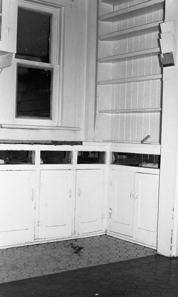
Northeast side, shelves and cupboards
https://search.heritageburnaby.ca/link/museumdescription10752
- Repository
- Burnaby Village Museum
- Date
- May 6, 1988
- Collection/Fonds
- Burnaby Village Museum fonds
- Description Level
- Item
- Physical Description
- 1 photograph : b&w negative ; 35 mm
- Scope and Content
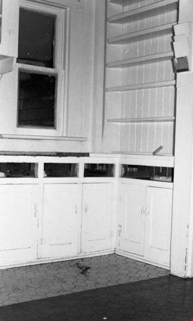
- Photograph of the northeast side of the Love farmhouse kitchen with cupboards and shelving. The house is located at 7651 Cumberland Street (the corner of 14th Avenue and Cumberland Street).
- Repository
- Burnaby Village Museum
- Collection/Fonds
- Burnaby Village Museum fonds
- Series
- Jesse Love farmhouse series
- Description Level
- Item
- Physical Description
- 1 photograph : b&w negative ; 35 mm
- Material Details
- Photograph is part of Film roll "C" - 36 b&w photographs that are a part of a collection described as BV018.41.83
- Scope and Content
- Photograph of the northeast side of the Love farmhouse kitchen with cupboards and shelving. The house is located at 7651 Cumberland Street (the corner of 14th Avenue and Cumberland Street).
- Subjects
- Buildings - Heritage
- Geographic Access
- Cumberland Street
- Street Address
- 7651 Cumberland Street
- Accession Code
- BV018.41.275
- Access Restriction
- No restrictions
- Reproduction Restriction
- No known restrictions
- Date
- May 6, 1988
- Media Type
- Photograph
- Historic Neighbourhood
- East Burnaby (Historic Neighbourhood)
- Planning Study Area
- Cariboo-Armstrong Area
- Related Material
- See BV018.41.82 for File Level Description
- Scan Resolution
- 2400
- Scan Date
- 5/19/2019
- Scale
- 100
- Photographer
- Wolf, Jim
- Notes
- Title based on contents of photograph
- Photograph is a part of file level description "Photographic documentation of changes and move" BV018.41.82
Images
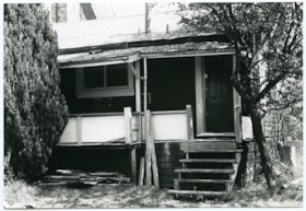
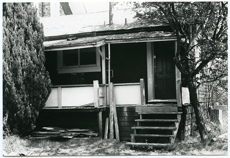
North side exterior of kitchen and porch
https://search.heritageburnaby.ca/link/museumdescription10704
- Repository
- Burnaby Village Museum
- Date
- May 4, 1988
- Collection/Fonds
- Burnaby Village Museum fonds
- Description Level
- Item
- Physical Description
- 1 photograph : b&w ; 13 x 9 cm
- Scope and Content
- Photograph of the north side exterior of the Jesse Love farmhouse with the kitchen and porch. The farmhouse is located at 7651 Cumberland Street (the corner of 14th Avenue and Cumberland Street) in Burnaby.
- Repository
- Burnaby Village Museum
- Collection/Fonds
- Burnaby Village Museum fonds
- Series
- Jesse Love farmhouse series
- Description Level
- Item
- Physical Description
- 1 photograph : b&w ; 13 x 9 cm
- Material Details
- Photograph is part of Film roll "B" - 24 b&w photographs that are a part of a collection described as BV018.41.82
- Scope and Content
- Photograph of the north side exterior of the Jesse Love farmhouse with the kitchen and porch. The farmhouse is located at 7651 Cumberland Street (the corner of 14th Avenue and Cumberland Street) in Burnaby.
- Subjects
- Buildings - Heritage
- Geographic Access
- Cumberland Street
- Street Address
- 7651 Cumberland Street
- Accession Code
- BV018.41.227
- Access Restriction
- No restrictions
- Reproduction Restriction
- No known restrictions
- Date
- May 4, 1988
- Media Type
- Photograph
- Historic Neighbourhood
- East Burnaby (Historic Neighbourhood)
- Planning Study Area
- Cariboo-Armstrong Area
- Related Material
- See BV018.41.82 for File Level Description
- Scan Resolution
- 600
- Scan Date
- 27-May-19
- Scale
- 100
- Photographer
- Wolf, Jim
- Notes
- Title based on contents of photograph
- Photograph is a part of file level description "Photographic documentation of changes and move" BV018.41.82
Images
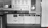
North side of kitchen
https://search.heritageburnaby.ca/link/museumdescription10751
- Repository
- Burnaby Village Museum
- Date
- May 6, 1988
- Collection/Fonds
- Burnaby Village Museum fonds
- Description Level
- Item
- Physical Description
- 1 photograph : b&w negative ; 35 mm
- Scope and Content
- Photograph of the north side of the Love farmhouse kitchen with cupboards and shelving. The house is located at 7651 Cumberland Street (the corner of 14th Avenue and Cumberland Street).
- Repository
- Burnaby Village Museum
- Collection/Fonds
- Burnaby Village Museum fonds
- Series
- Jesse Love farmhouse series
- Description Level
- Item
- Physical Description
- 1 photograph : b&w negative ; 35 mm
- Material Details
- Photograph is part of Film roll "C" - 36 b&w photographs that are a part of a collection described as BV018.41.83
- Scope and Content
- Photograph of the north side of the Love farmhouse kitchen with cupboards and shelving. The house is located at 7651 Cumberland Street (the corner of 14th Avenue and Cumberland Street).
- Subjects
- Buildings - Heritage
- Geographic Access
- Cumberland Street
- Street Address
- 7651 Cumberland Street
- Accession Code
- BV018.41.274
- Access Restriction
- No restrictions
- Reproduction Restriction
- No known restrictions
- Date
- May 6, 1988
- Media Type
- Photograph
- Historic Neighbourhood
- East Burnaby (Historic Neighbourhood)
- Planning Study Area
- Cariboo-Armstrong Area
- Related Material
- See BV018.41.82 for File Level Description
- Scan Resolution
- 2400
- Scan Date
- 5/19/2019
- Scale
- 100
- Photographer
- Wolf, Jim
- Notes
- Title based on contents of photograph
- Photograph is a part of file level description "Photographic documentation of changes and move" BV018.41.82
Images

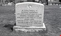
North side of tombstone
https://search.heritageburnaby.ca/link/museumdescription10739
- Repository
- Burnaby Village Museum
- Date
- May 6, 1988
- Collection/Fonds
- Burnaby Village Museum fonds
- Description Level
- Item
- Physical Description
- 1 photograph : b&w negative ; 35 mm
- Scope and Content
- Photograph of north side of Love family tombstone in New Westminster cemetary. Inscription reads: "In Loving Memory of / GEORGE LEONARD / DIED APRIL 19, 1909 - AGED 78 YEARS / THOMAS ROBERT LOVE / BORN SEPT 17, 1887 - DIED NOV 23, 1918 / HENRY LOVE / BORN AUG 24, 1883 - DIED MAR 15, 1956 / 1883 ELI…
- Repository
- Burnaby Village Museum
- Collection/Fonds
- Burnaby Village Museum fonds
- Series
- Jesse Love farmhouse series
- Description Level
- Item
- Physical Description
- 1 photograph : b&w negative ; 35 mm
- Material Details
- Photograph is part of Film roll "C" - 36 b&w photographs that are a part of a collection described as BV018.41.83
- Scope and Content
- Photograph of north side of Love family tombstone in New Westminster cemetary. Inscription reads: "In Loving Memory of / GEORGE LEONARD / DIED APRIL 19, 1909 - AGED 78 YEARS / THOMAS ROBERT LOVE / BORN SEPT 17, 1887 - DIED NOV 23, 1918 / HENRY LOVE / BORN AUG 24, 1883 - DIED MAR 15, 1956 / 1883 ELIZABETH W. LOVE 1976 / "At Rest"
- Subjects
- Cemeteries
- Names
- Leonard, George
- Love, Thomas "Bob" Robert
- Love, Henry
- Love, Elizabeth Washington Lewis, 1883-1976
- Geographic Access
- New Westminster
- Accession Code
- BV018.41.262
- Access Restriction
- No restrictions
- Reproduction Restriction
- No known restrictions
- Date
- May 6, 1988
- Media Type
- Photograph
- Related Material
- See BV018.41.82 for File Level Description
- Scan Resolution
- 2400
- Scan Date
- 5/19/2019
- Scale
- 100
- Photographer
- Wolf, Jim
- Notes
- Title based on contents of photograph
- Photograph is a part of file level description "Photographic documentation of changes and move" BV018.41.82
Images
![Northwest corner of Middlegate Shopping Centre property, [between 2003 and 2004] thumbnail](/media/hpo/_Data/_BVM_Images/2022/2022_0012_0002_001.jpg?width=280)
Northwest corner of Middlegate Shopping Centre property
https://search.heritageburnaby.ca/link/museumdescription18739
- Repository
- Burnaby Village Museum
- Date
- [between 2003 and 2004]
- Collection/Fonds
- Burnaby Village Museum Photograph collection
- Description Level
- Item
- Physical Description
- 1 photograph : col. print ; 10 x 25.5 cm
- Scope and Content
- Photograph of the northwest corner of the Middlegate Shopping Centre property looking southeast from Collier Street towards Hall Avenue and Kingsway. White building was a liquor store. Future site of Highgate Village development.
- Repository
- Burnaby Village Museum
- Collection/Fonds
- Burnaby Village Museum Photograph collection
- Description Level
- Item
- Physical Description
- 1 photograph : col. print ; 10 x 25.5 cm
- Scope and Content
- Photograph of the northwest corner of the Middlegate Shopping Centre property looking southeast from Collier Street towards Hall Avenue and Kingsway. White building was a liquor store. Future site of Highgate Village development.
- Geographic Access
- Collier Street
- Accession Code
- BV022.12.2
- Access Restriction
- No restrictions
- Reproduction Restriction
- No known restrictions
- Date
- [between 2003 and 2004]
- Media Type
- Photograph
- Historic Neighbourhood
- Edmonds (Historic Neighbourhood)
- Planning Study Area
- Edmonds Area
- Scan Resolution
- 600
- Scan Date
- 2022-05-17
- Photographer
- Hadwin, Juanita
- Notes
- Title based on contents of photograph
Images
![Northwest corner of Middlegate Shopping Centre property, [between 2003 and 2004] thumbnail](/media/hpo/_Data/_BVM_Images/2022/2022_0012_0002_001.jpg)
![Northwest corner of Middlegate Shopping Centre property, [between 2003 and 2004] thumbnail](/media/hpo/_Data/_BVM_Images/2022/2022_0012_0003_001.jpg?width=280)
Northwest corner of Middlegate Shopping Centre property
https://search.heritageburnaby.ca/link/museumdescription18740
- Repository
- Burnaby Village Museum
- Date
- [between 2003 and 2004]
- Collection/Fonds
- Burnaby Village Museum Photograph collection
- Description Level
- Item
- Physical Description
- 1 photograph : col. print ; 10 x 25.5 cm
- Scope and Content
- Photograph of the northwest corner of the Middlegate Shopping Centre property looking southeast from Collier Street towards Hall Avenue and Kingsway. White building was a liquor store. Future site of Highgate Village development.
- Repository
- Burnaby Village Museum
- Collection/Fonds
- Burnaby Village Museum Photograph collection
- Description Level
- Item
- Physical Description
- 1 photograph : col. print ; 10 x 25.5 cm
- Scope and Content
- Photograph of the northwest corner of the Middlegate Shopping Centre property looking southeast from Collier Street towards Hall Avenue and Kingsway. White building was a liquor store. Future site of Highgate Village development.
- Geographic Access
- Collier Street
- Accession Code
- BV022.12.3
- Access Restriction
- No restrictions
- Reproduction Restriction
- No known restrictions
- Date
- [between 2003 and 2004]
- Media Type
- Photograph
- Historic Neighbourhood
- Edmonds (Historic Neighbourhood)
- Planning Study Area
- Edmonds Area
- Scan Resolution
- 600
- Scan Date
- 2022-05-17
- Photographer
- Hadwin, Juanita
- Notes
- Title based on contents of photograph
Images
![Northwest corner of Middlegate Shopping Centre property, [between 2003 and 2004] thumbnail](/media/hpo/_Data/_BVM_Images/2022/2022_0012_0003_001.jpg)
Oral history subseries
https://search.heritageburnaby.ca/link/archivedescription64783
- Repository
- City of Burnaby Archives
- Date
- 1969-1989
- Collection/Fonds
- Burnaby Historical Society fonds
- Description Level
- Subseries
- Physical Description
- 4 boxes of audio/visual materials
- Scope and Content
- Subseries consists of oral history tapes created from interviews with early Burnaby residents. Interviews appear to have been conducted by both Burnaby Village Museum staff and Burnaby Historical Society members. Subseries also includes oral history tapes conducted by history students while atte…
- Repository
- City of Burnaby Archives
- Date
- 1969-1989
- Collection/Fonds
- Burnaby Historical Society fonds
- Subseries
- Oral history subseries
- Physical Description
- 4 boxes of audio/visual materials
- Material Details
- Audio cassette tapes and 30 magnetic tape reels
- Description Level
- Subseries
- Scope and Content
- Subseries consists of oral history tapes created from interviews with early Burnaby residents. Interviews appear to have been conducted by both Burnaby Village Museum staff and Burnaby Historical Society members. Subseries also includes oral history tapes conducted by history students while attending Simon Fraser University. A number of the SFU tapes are titled either "Burnaby in the Thirties" or "Local History Tapes."
- Media Type
- Sound Recording
- Notes
- MSS137, 100-13-01:100-13-25
- Paper finding aids accompany this series
- Interviews were digitized in 2010 allowing them to be accessible on Heritage Burnaby. The digitization project was initiated by the Community Heritage Commission with support from City of Burnaby Council and the BC History Digitization Program of the Irving K. Barber Learning Centre, University of British Columbia. It was recognized by the Heritage Society of BC with an award in 2012.
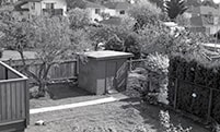
Outbuilding in next yard, southwest view from kitchen roof
https://search.heritageburnaby.ca/link/museumdescription10736
- Repository
- Burnaby Village Museum
- Date
- May 6, 1988
- Collection/Fonds
- Burnaby Village Museum fonds
- Description Level
- Item
- Physical Description
- 1 photograph : b&w negative ; 35 mm
- Scope and Content
- Photograph of outbuilding in yard next to the Love farmhouse located at 7651 Cumberland Street (the corner of 14th Avenue and Cumberland Street).
- Repository
- Burnaby Village Museum
- Collection/Fonds
- Burnaby Village Museum fonds
- Series
- Jesse Love farmhouse series
- Description Level
- Item
- Physical Description
- 1 photograph : b&w negative ; 35 mm
- Material Details
- Photograph is part of Film roll "C" - 36 b&w photographs that are a part of a collection described as BV018.41.83
- Scope and Content
- Photograph of outbuilding in yard next to the Love farmhouse located at 7651 Cumberland Street (the corner of 14th Avenue and Cumberland Street).
- Subjects
- Buildings - Heritage
- Geographic Access
- Cumberland Street
- Street Address
- 7651 Cumberland Street
- Accession Code
- BV018.41.259
- Access Restriction
- No restrictions
- Reproduction Restriction
- No known restrictions
- Date
- May 6, 1988
- Media Type
- Photograph
- Historic Neighbourhood
- East Burnaby (Historic Neighbourhood)
- Planning Study Area
- Cariboo-Armstrong Area
- Related Material
- See BV018.41.82 for File Level Description
- Scan Resolution
- 2400
- Scan Date
- 5/19/2019
- Scale
- 100
- Photographer
- Wolf, Jim
- Notes
- Title based on contents of photograph
- Photograph is a part of file level description "Photographic documentation of changes and move" BV018.41.82
Images
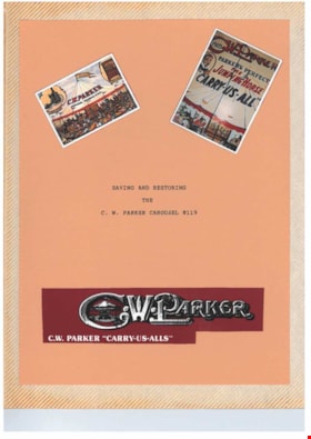
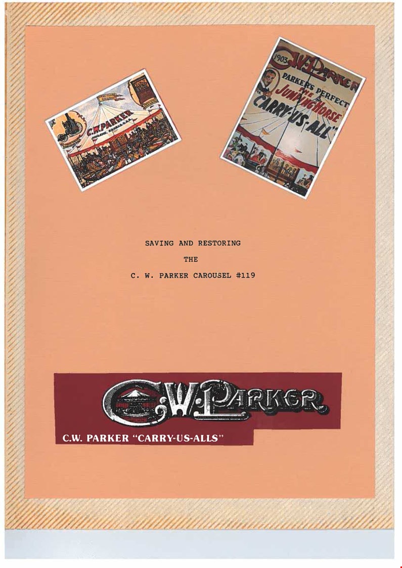
Parker Carousel Volume I
https://search.heritageburnaby.ca/link/museumdescription4555
- Repository
- Burnaby Village Museum
- Date
- 1989-2004
- Collection/Fonds
- Keith Jamieson fonds
- Description Level
- Item
- Physical Description
- 1 album (4 photographs + textual records + ephemera)
- Scope and Content
- Item consists of one of three scrapbooks titled, "Parker Carousel Volume 1- Saving and Restoring the C.W. Parker Carousel no. 119". The scrapbook contains newspaper clippings, correspondence, newsletters and original photographs documenting "The Friends of the Carousel" fundraising endeavours as we…
- Repository
- Burnaby Village Museum
- Collection/Fonds
- Keith Jamieson fonds
- Description Level
- Item
- Physical Description
- 1 album (4 photographs + textual records + ephemera)
- Scope and Content
- Item consists of one of three scrapbooks titled, "Parker Carousel Volume 1- Saving and Restoring the C.W. Parker Carousel no. 119". The scrapbook contains newspaper clippings, correspondence, newsletters and original photographs documenting "The Friends of the Carousel" fundraising endeavours as well as the restoration and installation of the C.W. Parker carouselno. 119. The carousel was rescued from the PNE and re-installed at the Burnaby Village Museum.
- Subjects
- Recreational Devices - Carousels
- Names
- Lower Mainland Association of the Friends of the Vancouver Carousel
- Jamieson, Keith
- Jamieson, Pat
- Pacific National Exhibition (PNE)
- C.W. Parker no. 119 Carousel
- Accession Code
- BV015.41.1
- Date
- 1989-2004
- Media Type
- Photograph
- Textual Record
- Arrangement
- Scrapbooks were arranged by Keith and Pat Jamieson before donation.
- Notes
- Title based on contents of item
Images