More like 'Gilmore Avenue and Douglas Road'
Narrow Results By
Decade
- 2020s 148
- 2010s 125
- 2000s 683
- 1990s 740
- 1980s 541
- 1970s 1053
- 1960s 403
- 1950s 573
- 1940s 693
- 1930s
- 1920s 722
- 1910s 694
- 1900s 289
- 1890s
- 1880s 71
- 1870s 5
- 1860s 3
- 1850s 1
- 1840s 1
- 1830s 1
- 1820s 1
- 1810s 1
- 1800s 1
- 1790s 1
- 1780s 1
- 1770s 1
- 1760s 1
- 1750s 1
- 1740s 1
- 1730s 1
- 1720s 1
- 1710s 1
- 1700s
- 1690s 1
- 1680s 1
- 1670s 1
- 1660s 1
- 1650s 1
- 1640s 1
- 1630s 1
- 1620s 1
- 1610s 1
- 1600s 1
Subject
- Accidents - Train Accidents 8
- Advertising Medium - Signs and Signboards 4
- Aerial Photographs 1
- Agricultural Tools and Equipment 1
- Agricultural Tools and Equipment - Gardening Equipment 1
- Agriculture 1
- Agriculture - Crops 2
- Agriculture - Dairy 1
- Agriculture - Farms 11
- Agriculture - Fruit and Berries 1
- Animals - Birds 2
- Animals - Cows 1

Duncan & Margaret McGregor Estate 'Glen-Lyon' New Haven Barn
https://search.heritageburnaby.ca/link/landmark852
- Repository
- Burnaby Heritage Planning
- Description
- Designed in a vernacular architectural style, the New Haven Barn is a large gambrel-roofed barn located on the Edwardian era McGregor Estate 'Glen-Lyon,' overlooking the rich farmland of the Fraser River floodplain and near a ravine and forested area adjacent to Marine Drive in South Burnaby.
- Associated Dates
- 1939
- Formal Recognition
- Heritage Designation, Community Heritage Register
- Other Names
- Home of the Friendless, New Haven Borstal Home for Boys and Youthful Offenders, New Haven Correction Centre
- Street View URL
- Google Maps Street View
- Repository
- Burnaby Heritage Planning
- Other Names
- Home of the Friendless, New Haven Borstal Home for Boys and Youthful Offenders, New Haven Correction Centre
- Geographic Access
- Marine Drive
- Associated Dates
- 1939
- Formal Recognition
- Heritage Designation, Community Heritage Register
- Enactment Type
- Bylaw No. 12183
- Enactment Date
- 11/12/2006
- Description
- Designed in a vernacular architectural style, the New Haven Barn is a large gambrel-roofed barn located on the Edwardian era McGregor Estate 'Glen-Lyon,' overlooking the rich farmland of the Fraser River floodplain and near a ravine and forested area adjacent to Marine Drive in South Burnaby.
- Heritage Value
- The site is historically significant for its association with early social welfare and correctional reform. The estate was sold in 1926 to an inter-denominational religious organization called the Home of the Friendless, which used it as their B.C. headquarters. The organization was charged with several cases of abuse and neglect in 1937, after which a Royal Commission was formed that led to new legislation to regulate and license all private welfare institutions. 'Glen-Lyon' was sold to the provincial government, and was dedicated in 1939 by the Lt.-Gov. E.W. Hamber for use as the New Haven Borstal Home for Boys and Youthful Offenders (later renamed the New Haven Correction Centre). The Borstal movement originated in England in the late nineteenth century, as an alternative to sending young offenders and runaways to prisons by providing reformatories that focused on discipline and vocational skill. This site’s role as the first North American institution devoted to the Borstal School philosophy was historic, and influenced corrections programs across Canada. The New Haven Barn is a significant feature from its development in 1939 as the Borstal School, designed by Chief Provincial Architect Henry Whittaker of the Department of Public Works, and is the only remaining structure of its kind in Burnaby.
- Defining Elements
- Key elements that define the heritage character of the New Haven Barn include its: - gambrel-roofed barn with roof vent with finial, sliding hay loft and access doors, small multi-pane windows, and lapped wooden siding
- Historic Neighbourhood
- Fraser Arm (Historic Neighbourhood)
- Planning Study Area
- Big Bend Area
- Architect
- Henry Whittaker
- Function
- Primary Historic--Estate
- Community
- Burnaby
- Cadastral Identifier
- 003-004-661
- Boundaries
- 'Glen-Lyon' is comprised of a single residential lot located at 4250 Marine Drive, Burnaby.
- Area
- 230873.18
- Contributing Resource
- Building
- Ownership
- Private
- Names
- Whittaker, George
- New Haven Borstal Home for Boys and Youthful Offenders
- New Haven Correction Centre
- Borstal School
- Street Address
- 4250 Marine Drive
- Street View URL
- Google Maps Street View
Images


![Capitol Hill, [193-] (date of original), copied 1986 thumbnail](/media/hpo/_Data/_Archives_Images/_Unrestricted/126/189-001.jpg?width=280)
Capitol Hill
https://search.heritageburnaby.ca/link/archivedescription35080
- Repository
- City of Burnaby Archives
- Date
- [193-] (date of original), copied 1986
- Collection/Fonds
- Burnaby Historical Society fonds
- Description Level
- Item
- Physical Description
- 1 photograph : b&w ; 10.0 x 15.2 cm print
- Scope and Content
- Photograph of a logging road on the north face of Capitol Hill. Burrard Inlet can be seen in the background. An annotation in the photograph register describes it as a "road cut to take timber on side hill for destitute family's heat and cooking."
- Repository
- City of Burnaby Archives
- Date
- [193-] (date of original), copied 1986
- Collection/Fonds
- Burnaby Historical Society fonds
- Subseries
- Marjorie Coe subseries
- Physical Description
- 1 photograph : b&w ; 10.0 x 15.2 cm print
- Description Level
- Item
- Record No.
- 189-001
- Access Restriction
- No restrictions
- Reproduction Restriction
- No known restrictions
- Accession Number
- BHS1986-40
- Scope and Content
- Photograph of a logging road on the north face of Capitol Hill. Burrard Inlet can be seen in the background. An annotation in the photograph register describes it as a "road cut to take timber on side hill for destitute family's heat and cooking."
- Subjects
- Geographic Features - Roads
- Land Clearing
- Media Type
- Photograph
- Notes
- Title based on contents of photograph
- Historic Neighbourhood
- Capitol Hill (Historic Neighbourhood)
- Planning Study Area
- Capitol Hill Area
Images
![Capitol Hill, [193-] (date of original), copied 1986 thumbnail](/media/hpo/_Data/_Archives_Images/_Unrestricted/126/189-001.jpg)
![Douglas Road, [1897] (date of original), copied 1978 thumbnail](/media/hpo/_Data/_BVM_Images/1978/1978_0001_0001_001.jpg?width=280)
Douglas Road
https://search.heritageburnaby.ca/link/museumdescription447
- Repository
- Burnaby Village Museum
- Date
- [1897] (date of original), copied 1978
- Collection/Fonds
- Burnaby Village Museum Photograph collection
- Description Level
- Item
- Physical Description
- 1 photograph : b&w ; 20.2 x 25.2 cm print
- Scope and Content
- Photograph of Douglas Road (later renamed in part Canada Way), near Stanley Street. To the right is the Sprott family property, where a few wooden buildings are visible in the cleared area. Charles Sprott, head of the Sprott family, was an important Burnaby politician who was continuously elected t…
- Repository
- Burnaby Village Museum
- Collection/Fonds
- Burnaby Village Museum Photograph collection
- Description Level
- Item
- Physical Description
- 1 photograph : b&w ; 20.2 x 25.2 cm print
- Scope and Content
- Photograph of Douglas Road (later renamed in part Canada Way), near Stanley Street. To the right is the Sprott family property, where a few wooden buildings are visible in the cleared area. Charles Sprott, head of the Sprott family, was an important Burnaby politician who was continuously elected to serve in the municiality as councillor from 1895 to 1903 and as Reeve from 1904 to 1905.
- Subjects
- Geographic Features - Roads
- Land Clearing
- Geographic Access
- Douglas Road
- Canada Way
- Stanley Street
- Accession Code
- HV978.1.1
- Access Restriction
- No restrictions
- Reproduction Restriction
- No known restrictions
- Date
- [1897] (date of original), copied 1978
- Media Type
- Photograph
- Historic Neighbourhood
- Burnaby Lake (Historic Neighbourhood)
- Planning Study Area
- Lakeview-Mayfield Area
- Scan Resolution
- 600
- Scan Date
- 2023-07-25
- Notes
- Title based on contents of photograph
Images
![Douglas Road, [1897] (date of original), copied 1978 thumbnail](/media/hpo/_Data/_BVM_Images/1978/1978_0001_0001_001.jpg)

Rumble Street
https://search.heritageburnaby.ca/link/archivedescription34255
- Repository
- City of Burnaby Archives
- Date
- 1932
- Collection/Fonds
- Burnaby Historical Society fonds
- Description Level
- Item
- Physical Description
- 1 photograph : b&w ; 12.2 x 17.7 cm
- Scope and Content
- Photograph of Rumble Street looking east toward Patterson Avenue, located where the house on the left can be seen.
- Repository
- City of Burnaby Archives
- Date
- 1932
- Collection/Fonds
- Burnaby Historical Society fonds
- Subseries
- Photographs subseries
- Physical Description
- 1 photograph : b&w ; 12.2 x 17.7 cm
- Description Level
- Item
- Record No.
- 011-002
- Access Restriction
- No restrictions
- Reproduction Restriction
- No known restrictions
- Accession Number
- BHS2007-04
- Scope and Content
- Photograph of Rumble Street looking east toward Patterson Avenue, located where the house on the left can be seen.
- Media Type
- Photograph
- Notes
- Title based on contents of photograph
- Annotation at bottom of Copy 2 reads, "Rumble St. just after Municipal dump was filled / Facing east house on left is where Patterson Avenue [is]"
- Geographic Access
- Rumble Street
- Patterson Avenue
- Historic Neighbourhood
- Alta-Vista (Historic Neighbourhood)
- Planning Study Area
- Sussex-Nelson Area
- Suncrest Area
Images


Clearing land with a team of oxen
https://search.heritageburnaby.ca/link/archivedescription39524
- Repository
- City of Burnaby Archives
- Date
- 1890
- Collection/Fonds
- Peers Family and Hill Family fonds
- Description Level
- Item
- Physical Description
- 1 photograph : sepia ; 15.6 x 23.8 cm on page 21.5 x 28 cm (pasted in album)
- Scope and Content
- Photograph of a team of oxen being used to clear land and haul logs on skid road. Five unidentified lumberjacks can be seen standing alongside the animals.
- Repository
- City of Burnaby Archives
- Date
- 1890
- Collection/Fonds
- Peers Family and Hill Family fonds
- Physical Description
- 1 photograph : sepia ; 15.6 x 23.8 cm on page 21.5 x 28 cm (pasted in album)
- Description Level
- Item
- Record No.
- 477-843
- Access Restriction
- No restrictions
- Reproduction Restriction
- No known restrictions
- Accession Number
- 2007-12
- Scope and Content
- Photograph of a team of oxen being used to clear land and haul logs on skid road. Five unidentified lumberjacks can be seen standing alongside the animals.
- Subjects
- Woodworking Tools and Equipment - Logging Machinery
- Industries - Forestry
- Animals - Oxen
- Occupations - Lumberjacks
- Land Clearing
- Industries - Logging/lumber
- Media Type
- Photograph
- Notes
- Title based on contents of photograph
Images


Alfred Bingham's writings - Track 3
https://search.heritageburnaby.ca/link/oralhistory253
- Repository
- City of Burnaby Archives
- Date Range
- 1903-1940
- Length
- 0:09:46
- Summary
- This portion of the recording includes Alfred Bingham's descriptions of road construction in Burnaby, including the names of the settlers and logging companies involved in their construction. Alfred discusses the changes that took place during World War I, along with municipal Relief work that he t…
- Repository
- City of Burnaby Archives
- Summary
- This portion of the recording includes Alfred Bingham's descriptions of road construction in Burnaby, including the names of the settlers and logging companies involved in their construction. Alfred discusses the changes that took place during World War I, along with municipal Relief work that he took part in at Burnaby Mountain. Alfred also discusses early schools and mentions his wife, Ada Bingham.
- Date Range
- 1903-1940
- Photo Info
- Alfred Bingham, April 20, 1947. Item no. 010-066
- Length
- 0:09:46
- Planning Study Area
- Burnaby Mountain Area
- Scope and Content
- Recording is of Alfred Bingham's writings, as read by Alfred Bingham. Major themes discussed are: Pioneers, early days in Burnaby and the Co-op Movement. To view "Narrow By" terms for each track expand this description and see "Notes".
- Biographical Notes
- Alfred "Alf" Bingham was born in England in 1892 and moved to Canada in 1912. His first job in Canada was laying track for the Grand Trunk Pacific Railway (GTPR) from Edmonton to McBride in 1912. His second was in Vancouver at the Rat Portage Mill on False Creek, working on the Resaw machine. He quit after one week due to poor working conditions. After taking part in the 1919 Winnipeg General Strike as a delegate of the Retail and Mailorder Union (A.F.L.) on the Winnipeg Trades and Labour Council, Alfred moved to Burnaby where he and fellow Burnaby residents Aungus McLean and Percy Little worked ten hour days to build a Shingle Mill on the edge of Burnaby Lake for Simpson & Giberson. George Green, carpenter and millwright (author of “The History of Burnaby”) also helped in the construction of the mill. Alfred built his own home from lumber cut from the mill in the Lochdale area on Sherlock Street between Curtis Street and Kitchener Street. On April 10, 1920 Alfred married Mary Jane “Ada” Reynolds. Alfred and Ada often took in foster children during their marriage. Due to her nursing experience, Ada was often called upon to deliver babies in the Burnaby area. Alfred and Ada Bingham were instrumental members of the Army of the Common Good, collecting vegetables and grains from growers in the area and even producing over 125 tons of vegetables from its own gardens to feed children and youth suffering from the lack of resources during the Depression years. The army was in operation for ten years and during that time the members organised the Credit Union movement of British Columbia and drew up the Credit Union act thorough the Vancouver Co-operative Council. They also started Co-Op stores and the Co-Op Wholesale Society. Alfred was also Secretary of the Burnaby Housing committee and in 1946 he became the Secretary of the North Burnaby Labour Progressive Party (LPP). Mary Jane “Ada” (Reynolds) Bingham died on August 9, 1969. Her husband Alfred died on April 29, 1979.
- Total Tracks
- 12
- Total Length
- 1:38:06
- Interviewee Name
- Bingham, Alfred "Alf"
- Collection/Fonds
- Burnaby Historical Society fonds
- Subseries
- Oral history subseries
- Transcript Available
- MSS142-001 contains transcripts for each of the short stories
- Media Type
- Sound Recording
- Web Notes
- Interview was digitized in 2010 allowing it to be accessible on Heritage Burnaby. The digitization project was initiated by the Community Heritage Commission with support from City of Burnaby Council and the BC History Digitization Program of the Irving K. Barber Learning Centre, University of British Columbia. It was recognized by the Heritage Society of BC with an award in 2012.
Images

Audio Tracks
Track three of recording of Alfred Bingham's writings
Track three of recording of Alfred Bingham's writings
https://search.heritageburnaby.ca/media/hpo/_Data/_Archives_Oral_Histories/_Unrestricted/100-13-20-2/100-13-20-2_Track_3.mp3
Alfred Bingham's writings - Track 1
https://search.heritageburnaby.ca/link/oralhistory251
- Repository
- City of Burnaby Archives
- Date Range
- 1865-1919
- Length
- 0:10:18
- Summary
- This portion of the recording includes Alfred Bingham's essay entitled Stump Rangers, a listing of early settlers that includes addresses and short descriptions, essays on Confederation Park, land clearing and on Burnaby's first Council meeting.
- Repository
- City of Burnaby Archives
- Summary
- This portion of the recording includes Alfred Bingham's essay entitled Stump Rangers, a listing of early settlers that includes addresses and short descriptions, essays on Confederation Park, land clearing and on Burnaby's first Council meeting.
- Date Range
- 1865-1919
- Photo Info
- Alfred Bingham, April 20, 1947. Item no. 010-066
- Length
- 0:10:18
- Scope and Content
- Recording is of Alfred Bingham's writings, as read by Alfred Bingham. Major themes discussed are: Pioneers, early days in Burnaby and the Co-op Movement. To view "Narrow By" terms for each track expand this description and see "Notes".
- Biographical Notes
- Alfred "Alf" Bingham was born in England in 1892 and moved to Canada in 1912. His first job in Canada was laying track for the Grand Trunk Pacific Railway (GTPR) from Edmonton to McBride in 1912. His second was in Vancouver at the Rat Portage Mill on False Creek, working on the Resaw machine. He quit after one week due to poor working conditions. After taking part in the 1919 Winnipeg General Strike as a delegate of the Retail and Mailorder Union (A.F.L.) on the Winnipeg Trades and Labour Council, Alfred moved to Burnaby where he and fellow Burnaby residents Aungus McLean and Percy Little worked ten hour days to build a Shingle Mill on the edge of Burnaby Lake for Simpson & Giberson. George Green, carpenter and millwright (author of “The History of Burnaby”) also helped in the construction of the mill. Alfred built his own home from lumber cut from the mill in the Lochdale area on Sherlock Street between Curtis Street and Kitchener Street. On April 10, 1920 Alfred married Mary Jane “Ada” Reynolds. Alfred and Ada often took in foster children during their marriage. Due to her nursing experience, Ada was often called upon to deliver babies in the Burnaby area. Alfred and Ada Bingham were instrumental members of the Army of the Common Good, collecting vegetables and grains from growers in the area and even producing over 125 tons of vegetables from its own gardens to feed children and youth suffering from the lack of resources during the Depression years. The army was in operation for ten years and during that time the members organised the Credit Union movement of British Columbia and drew up the Credit Union act thorough the Vancouver Co-operative Council. They also started Co-Op stores and the Co-Op Wholesale Society. Alfred was also Secretary of the Burnaby Housing committee and in 1946 he became the Secretary of the North Burnaby Labour Progressive Party (LPP). Mary Jane “Ada” (Reynolds) Bingham died on August 9, 1969. Her husband Alfred died on April 29, 1979.
- Total Tracks
- 12
- Total Length
- 1:38:06
- Interviewee Name
- Bingham, Alfred "Alf"
- Collection/Fonds
- Burnaby Historical Society fonds
- Subseries
- Oral history subseries
- Transcript Available
- MSS142-001 contains transcripts for each of the short stories
- Media Type
- Sound Recording
- Web Notes
- Interview was digitized in 2010 allowing it to be accessible on Heritage Burnaby. The digitization project was initiated by the Community Heritage Commission with support from City of Burnaby Council and the BC History Digitization Program of the Irving K. Barber Learning Centre, University of British Columbia. It was recognized by the Heritage Society of BC with an award in 2012.
Images
Audio Tracks
Track one of recording of Alfred Bingham's writings
Track one of recording of Alfred Bingham's writings
https://search.heritageburnaby.ca/media/hpo/_Data/_Archives_Oral_Histories/_Unrestricted/100-13-20-2/100-13-20-2_Track_1.mp3![Barkerville in the '30s, [193-] thumbnail](/media/hpo/_Data/_Archives_Images/_Unrestricted/001/020-060.jpg?width=280)
Barkerville in the '30s
https://search.heritageburnaby.ca/link/archivedescription34353
- Repository
- City of Burnaby Archives
- Date
- [193-]
- Collection/Fonds
- Burnaby Historical Society fonds
- Description Level
- Item
- Physical Description
- 1 photograph : b&w ; 7.2 x 12 cm on page 17.5 x 26.5 cm
- Scope and Content
- Photograph of the town of Barkerville. Barkerville was a central town during the Cariboo Gold Rush. Photograph shows the town with a hill being cleared in the background. This photograph appears to have been taken by Arthur Peers, who travelled through the Fraser River Valley and worked on the c…
- Repository
- City of Burnaby Archives
- Date
- [193-]
- Collection/Fonds
- Burnaby Historical Society fonds
- Subseries
- Peers family subseries
- Physical Description
- 1 photograph : b&w ; 7.2 x 12 cm on page 17.5 x 26.5 cm
- Description Level
- Item
- Record No.
- 020-060
- Access Restriction
- No restrictions
- Reproduction Restriction
- No known restrictions
- Accession Number
- BHS2007-04
- Scope and Content
- Photograph of the town of Barkerville. Barkerville was a central town during the Cariboo Gold Rush. Photograph shows the town with a hill being cleared in the background. This photograph appears to have been taken by Arthur Peers, who travelled through the Fraser River Valley and worked on the construction of the Trans-Provincial Highway during the later 1920s.
- Media Type
- Photograph
- Photographer
- Peers, Arthur Francis "Mike"
- Notes
- Title based on caption accompanying photograph
Images
![Barkerville in the '30s, [193-] thumbnail](/media/hpo/_Data/_Archives_Images/_Unrestricted/001/020-060.jpg)
![Clearing Deer Lake frontage, [1891] thumbnail](/media/hpo/_Data/_Archives_Images/_Unrestricted/477/477-842.jpg?width=280)
Clearing Deer Lake frontage
https://search.heritageburnaby.ca/link/archivedescription39523
- Repository
- City of Burnaby Archives
- Date
- [1891]
- Collection/Fonds
- Peers Family and Hill Family fonds
- Description Level
- Item
- Physical Description
- 1 photograph : b&w ; 9.5 x 14.3 cm on page 21.5 x 8 cm (pasted in album)
- Scope and Content
- Photograph of a man and his dog sitting on a large felled tree along the shore of Deer Lake. The man is most likely Claude Hill, and early resident of the Deer Lake area.
- Repository
- City of Burnaby Archives
- Date
- [1891]
- Collection/Fonds
- Peers Family and Hill Family fonds
- Physical Description
- 1 photograph : b&w ; 9.5 x 14.3 cm on page 21.5 x 8 cm (pasted in album)
- Description Level
- Item
- Record No.
- 477-842
- Access Restriction
- No restrictions
- Reproduction Restriction
- No known restrictions
- Accession Number
- 2007-12
- Scope and Content
- Photograph of a man and his dog sitting on a large felled tree along the shore of Deer Lake. The man is most likely Claude Hill, and early resident of the Deer Lake area.
- Media Type
- Photograph
- Notes
- Title based on caption accompanying photograph
- Geographic Access
- Deer Lake
- Historic Neighbourhood
- Burnaby Lake (Historic Neighbourhood)
Images
![Clearing Deer Lake frontage, [1891] thumbnail](/media/hpo/_Data/_Archives_Images/_Unrestricted/477/477-842.jpg)
Interview with Reidun Seim by Kathy Bossort January 13, 2016 - Track 1
https://search.heritageburnaby.ca/link/oralhistory650
- Repository
- City of Burnaby Archives
- Date Range
- 1904-1940
- Length
- 0:11:22
- Summary
- This portion of the interview is about Reidun Seim talking about her father’s immigration to the USA in 1904 at age 16, his return to Norway and marrying Martine, her parents emigration from Norway to Vancouver in 1930, her father’s purchase of an acre of land on Curtis Street and building a two ro…
- Repository
- City of Burnaby Archives
- Summary
- This portion of the interview is about Reidun Seim talking about her father’s immigration to the USA in 1904 at age 16, his return to Norway and marrying Martine, her parents emigration from Norway to Vancouver in 1930, her father’s purchase of an acre of land on Curtis Street and building a two room house for the family, Reidun’s birth in 1931, and the family’s move to Curtis Street in 1932. She talks about her childhood memories of playing on a big stump and cedar log in the yard.
- Date Range
- 1904-1940
- Length
- 0:11:22
- Names
- Seim, Sjur
- Seim, Martine
- Geographic Access
- Curtis Street
- Historic Neighbourhood
- Lochdale (Historic Neighbourhood)
- Planning Study Area
- Lochdale Area
- Interviewer
- Bossort, Kathy
- Interview Date
- January 13, 2016
- Scope and Content
- Recording is of an interview with Reidun Seim conducted by Kathy Bossort. Reidun Seim was one of 23 participants interviewed as part of the Community Heritage Commission’s Burnaby Mountain Oral History Project. The interview is mainly about Reidun Seim’s memories about her parent’s farm on Curtis Street, events in her childhood, and the people who lived in or visited her neighborhood. She takes us on a tour of her neighborhood in the 1940s, telling us stories about families who lived on Curtis Street on and east of 7300 block, including people who lived on Burnaby Mountain in the old Hastings Grove subdivision above the end of municipal water service at Philips Avenue. She describes changes to Curtis Street, particularly after it provided access to Simon Fraser University in 1965. She also talks about her teaching career, and about how she values the green space and conservation area on Burnaby Mountain.
- Biographical Notes
- Reidun Seim was born in 1931 in Vancouver B.C. to Sjur and Martine Seim. Sjur and Martine Seim emigrated to Canada from Norway in 1930, and after settling in Vancouver, moved to an acre of land and a new home at the base of Burnaby Mountain in 1932. Sjur attended UBC to learn about poultry farming and began his own chicken and egg business in 1935. The farm animals and large garden also contributed to the family’s livelihood and self-sufficiency. The Curtis Street neighborhood was a lively place and extended well up Curtis Street on the west slope of Burnaby Mountain, where Reidun would babysit for families. Reidun attended Sperling Avenue Elementary School (Gr. 1-8), Burnaby North High School, and Vancouver Normal School for teacher training in 1950-1951. She began teaching primary grades in Port Coquitlam at James Park School. Most of her career was spent in North Delta, teaching at Kennedy and Annieville schools from 1954-1958, appointed Primary Consultant (1958-1960) and Primary Supervisor (1960-1985), before retiring in 1986. Reidun lived at home with her parents on Curtis Street, commuting to Delta, and continues to live in the original farmhouse.
- Total Tracks
- 14
- Total Length
- 2:35:58
- Interviewee Name
- Seim, Reidun
- Interview Location
- Burnaby City Hall in the Law Library
- Interviewer Bio
- Kathy Bossort is a retired archivist living in Ladner, BC. She worked at the Delta Museum and Archives after graduating from SLAIS (UBC) in 2001 with Masters degrees in library science and archival studies. Kathy grew up in Calgary, Alberta, and, prior to this career change, she lived in the West Kootenays, earning her living as a cook for BC tourist lodges and work camps. She continues to be interested in oral histories as a way to fill the gaps in the written record and bring richer meaning to history.
- Collection/Fonds
- Community Heritage Commission Special Projects fonds
- Media Type
- Sound Recording
Audio Tracks
Track one of interview with Reidun Seim
Track one of interview with Reidun Seim
https://search.heritageburnaby.ca/media/hpo/_Data/_Archives_Oral_Histories/_Unrestricted/MSS196-017/MSS196-017_Track_1.mp3![Rae Weir clearing land, [193-] (date of original), copied 1986 thumbnail](/media/hpo/_Data/_Archives_Images/_Unrestricted/204/204-173.jpg?width=280)
Rae Weir clearing land
https://search.heritageburnaby.ca/link/archivedescription35316
- Repository
- City of Burnaby Archives
- Date
- [193-] (date of original), copied 1986
- Collection/Fonds
- Burnaby Historical Society fonds
- Description Level
- Item
- Physical Description
- 1 photograph : b&w ; 12.7 x 17.8 cm print
- Scope and Content
- Photograph of Rae Weir clearing a lot on Jubilee Avenue with a D4 Caterpillar bulldozer. Rae Weir owned Jubilee Fuel and Transfer which did everything from clearing lots to excavating basements to delivering and selling fuels.
- Repository
- City of Burnaby Archives
- Date
- [193-] (date of original), copied 1986
- Collection/Fonds
- Burnaby Historical Society fonds
- Subseries
- Pioneer Tales subseries
- Physical Description
- 1 photograph : b&w ; 12.7 x 17.8 cm print
- Description Level
- Item
- Record No.
- 204-173
- Access Restriction
- No restrictions
- Reproduction Restriction
- No known restrictions
- Accession Number
- BHS1988-03
- Scope and Content
- Photograph of Rae Weir clearing a lot on Jubilee Avenue with a D4 Caterpillar bulldozer. Rae Weir owned Jubilee Fuel and Transfer which did everything from clearing lots to excavating basements to delivering and selling fuels.
- Media Type
- Photograph
- Notes
- Title based on contents of photograph
- Geographic Access
- Jubilee Avenue
- Historic Neighbourhood
- Central Park (Historic Neighbourhood)
- Planning Study Area
- Maywood Area
Images
![Rae Weir clearing land, [193-] (date of original), copied 1986 thumbnail](/media/hpo/_Data/_Archives_Images/_Unrestricted/204/204-173.jpg)
![Eagles garden and house, [193-] (date of original), copied 1996 thumbnail](/media/hpo/_Data/_Archives_Images/_Unrestricted/316/331-005.jpg?width=280)
Eagles garden and house
https://search.heritageburnaby.ca/link/archivedescription37187
- Repository
- City of Burnaby Archives
- Date
- [193-] (date of original), copied 1996
- Collection/Fonds
- Burnaby Historical Society fonds
- Description Level
- Item
- Physical Description
- 1 photograph : b&w ; 10 x 17 cm print
- Scope and Content
- Photograph of five people standing in front of the Eagles' front door, at the Eagles Estate.
- Repository
- City of Burnaby Archives
- Date
- [193-] (date of original), copied 1996
- Collection/Fonds
- Burnaby Historical Society fonds
- Subseries
- Eagles family subseries
- Physical Description
- 1 photograph : b&w ; 10 x 17 cm print
- Description Level
- Item
- Record No.
- 331-005
- Access Restriction
- No restrictions
- Reproduction Restriction
- No known restrictions
- Accession Number
- BHS1996-21
- Scope and Content
- Photograph of five people standing in front of the Eagles' front door, at the Eagles Estate.
- Media Type
- Photograph
- Notes
- Title based on contents of photograph
- Geographic Access
- Sperling Avenue
- Street Address
- 5655 Sperling Avenue
- Historic Neighbourhood
- Burnaby Lake (Historic Neighbourhood)
- Planning Study Area
- Morley-Buckingham Area
Images
![Eagles garden and house, [193-] (date of original), copied 1996 thumbnail](/media/hpo/_Data/_Archives_Images/_Unrestricted/316/331-005.jpg)
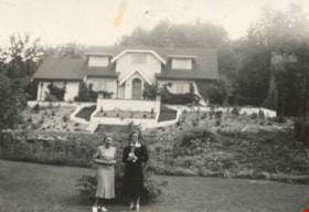
![Eagles house and landscaping, [1939] (date of original), copied 1996 thumbnail](/media/hpo/_Data/_Archives_Images/_Unrestricted/316/331-010.jpg?width=280)
Eagles house and landscaping
https://search.heritageburnaby.ca/link/archivedescription37192
- Repository
- City of Burnaby Archives
- Date
- [1939] (date of original), copied 1996
- Collection/Fonds
- Burnaby Historical Society fonds
- Description Level
- Item
- Physical Description
- 1 photograph : b&w ; 10 x 17 cm print
- Scope and Content
- Photograph of Drs. Blythe and Violet Eagles standing outside of their house with two other couples.
- Repository
- City of Burnaby Archives
- Date
- [1939] (date of original), copied 1996
- Collection/Fonds
- Burnaby Historical Society fonds
- Subseries
- Eagles family subseries
- Physical Description
- 1 photograph : b&w ; 10 x 17 cm print
- Description Level
- Item
- Record No.
- 331-010
- Access Restriction
- No restrictions
- Reproduction Restriction
- No known restrictions
- Accession Number
- BHS1996-21
- Scope and Content
- Photograph of Drs. Blythe and Violet Eagles standing outside of their house with two other couples.
- Media Type
- Photograph
- Notes
- Title based on contents of photograph
- Geographic Access
- Sperling Avenue
- Street Address
- 5655 Sperling Avenue
- Historic Neighbourhood
- Burnaby Lake (Historic Neighbourhood)
- Planning Study Area
- Morley-Buckingham Area
Images
![Eagles house and landscaping, [1939] (date of original), copied 1996 thumbnail](/media/hpo/_Data/_Archives_Images/_Unrestricted/316/331-010.jpg)
![Violet Eagles in the garden, [1939] (date of original), copied 1996 thumbnail](/media/hpo/_Data/_Archives_Images/_Unrestricted/316/331-006.jpg?width=280)
Violet Eagles in the garden
https://search.heritageburnaby.ca/link/archivedescription37188
- Repository
- City of Burnaby Archives
- Date
- [1939] (date of original), copied 1996
- Collection/Fonds
- Burnaby Historical Society fonds
- Description Level
- Item
- Physical Description
- 1 photograph : b&w ; 10 x 17 cm print
- Scope and Content
- Photograph of Violet Eagles standing in the garden at the Eagles Estate with a another woman and a child and a dog.
- Repository
- City of Burnaby Archives
- Date
- [1939] (date of original), copied 1996
- Collection/Fonds
- Burnaby Historical Society fonds
- Subseries
- Eagles family subseries
- Physical Description
- 1 photograph : b&w ; 10 x 17 cm print
- Description Level
- Item
- Record No.
- 331-006
- Access Restriction
- No restrictions
- Reproduction Restriction
- No known restrictions
- Accession Number
- BHS1996-21
- Scope and Content
- Photograph of Violet Eagles standing in the garden at the Eagles Estate with a another woman and a child and a dog.
- Subjects
- Geographic Features - Gardens
- Buildings - Residential - Houses
- Buildings - Heritage
- Animals - Dogs
- Names
- Eagles, Dr. Violet
- Media Type
- Photograph
- Notes
- Title based on contents of photograph
- Geographic Access
- Sperling Avenue
- Street Address
- 5655 Sperling Avenue
- Historic Neighbourhood
- Burnaby Lake (Historic Neighbourhood)
- Planning Study Area
- Morley-Buckingham Area
Images
![Violet Eagles in the garden, [1939] (date of original), copied 1996 thumbnail](/media/hpo/_Data/_Archives_Images/_Unrestricted/316/331-006.jpg)
Violet Eagles outside her home
https://search.heritageburnaby.ca/link/archivedescription38323
- Repository
- City of Burnaby Archives
- Date
- 1939
- Collection/Fonds
- Burnaby Historical Society fonds
- Description Level
- Item
- Physical Description
- 1 photograph : b&w ; 6.5 x 9 cm + 1 b&w negative ; 6 x 5 cm
- Scope and Content
- Photograph of Violet Eagles and a friend standing on the lower lawn in front of the Eagles' estate at Deer Lake.
- Repository
- City of Burnaby Archives
- Date
- 1939
- Collection/Fonds
- Burnaby Historical Society fonds
- Subseries
- Eagles family subseries
- Physical Description
- 1 photograph : b&w ; 6.5 x 9 cm + 1 b&w negative ; 6 x 5 cm
- Description Level
- Item
- Record No.
- 404-015
- Access Restriction
- No restrictions
- Reproduction Restriction
- No known restrictions
- Accession Number
- BHS2000-4
- Scope and Content
- Photograph of Violet Eagles and a friend standing on the lower lawn in front of the Eagles' estate at Deer Lake.
- Names
- Eagles, Dr. Violet
- Media Type
- Photograph
- Notes
- Title based on contents of photograph.
- Geographic Access
- Sperling Avenue
- Street Address
- 5655 Sperling Avenue
- Historic Neighbourhood
- Burnaby Lake (Historic Neighbourhood)
- Planning Study Area
- Morley-Buckingham Area
Images

![Brick Houses under Construction, [between 1899 and 1910] thumbnail](/media/hpo/_Data/_Archives_Images/_Unrestricted/513/514-003.jpg?width=280)
Brick Houses under Construction
https://search.heritageburnaby.ca/link/archivedescription64654
- Repository
- City of Burnaby Archives
- Date
- [between 1899 and 1910]
- Collection/Fonds
- Ernest Winch fonds
- Description Level
- Item
- Physical Description
- 1 photograph : b&w cabinet card ; 10 x 14.5 cm, mounted on card 10.5 x 16.5 cm
- Scope and Content
- Photograph of two brick houses under construction on High Street at Epping, Essex, England. These buildings were constructed by Ernest E. Winch.
- Repository
- City of Burnaby Archives
- Date
- [between 1899 and 1910]
- Collection/Fonds
- Ernest Winch fonds
- Physical Description
- 1 photograph : b&w cabinet card ; 10 x 14.5 cm, mounted on card 10.5 x 16.5 cm
- Description Level
- Item
- Record No.
- 514-003
- Access Restriction
- No restrictions
- Reproduction Restriction
- No known restrictions
- Accession Number
- 2010-06
- Scope and Content
- Photograph of two brick houses under construction on High Street at Epping, Essex, England. These buildings were constructed by Ernest E. Winch.
- Subjects
- Construction
- Buildings - Residential - Houses
- Construction Tools and Equipment
- Occupations - Labourers
- Media Type
- Photograph
- Photographer
- Challoner-Courtenay, E.J.
- Notes
- Title based on contents of photograph
Images
![Brick Houses under Construction, [between 1899 and 1910] thumbnail](/media/hpo/_Data/_Archives_Images/_Unrestricted/513/514-003.jpg)
![Bellinger and Baker children, [1929 or 1930] (date of original), copied 1991 thumbnail](/media/hpo/_Data/_Archives_Images/_Unrestricted/370/370-063.jpg?width=280)
Bellinger and Baker children
https://search.heritageburnaby.ca/link/archivedescription37475
- Repository
- City of Burnaby Archives
- Date
- [1929 or 1930] (date of original), copied 1991
- Collection/Fonds
- Burnaby Historical Society fonds
- Description Level
- Item
- Physical Description
- 1 photograph : b&w ; 4.4 x 3.0 cm print on contact sheet 20.2 x 25.3 cm
- Scope and Content
- Photograph of five children standing on the board sidewalk in front of 2827 Earl Avenue (later 6296 Pearl Avenue). Left to right: Marion Bellinger, Christine Bellinger, Robert Bellinger, Barbara Baker, and Barbara's sister. Adults are seated on the porch behind them.
- Repository
- City of Burnaby Archives
- Date
- [1929 or 1930] (date of original), copied 1991
- Collection/Fonds
- Burnaby Historical Society fonds
- Subseries
- Burnaby Image Bank subseries
- Physical Description
- 1 photograph : b&w ; 4.4 x 3.0 cm print on contact sheet 20.2 x 25.3 cm
- Description Level
- Item
- Record No.
- 370-063
- Access Restriction
- No restrictions
- Reproduction Restriction
- Reproduce for fair dealing purposes only
- Accession Number
- BHS1999-03
- Scope and Content
- Photograph of five children standing on the board sidewalk in front of 2827 Earl Avenue (later 6296 Pearl Avenue). Left to right: Marion Bellinger, Christine Bellinger, Robert Bellinger, Barbara Baker, and Barbara's sister. Adults are seated on the porch behind them.
- Media Type
- Photograph
- Photographer
- Bellinger, Bernard
- Notes
- Title based on contents of photograph
- 1 b&w copy negative accompanying
- Geographic Access
- Pearl Avenue
- Street Address
- 6296 Pearl Avenue
- Historic Neighbourhood
- Central Park (Historic Neighbourhood)
- Planning Study Area
- Windsor Area
Images
![Bellinger and Baker children, [1929 or 1930] (date of original), copied 1991 thumbnail](/media/hpo/_Data/_Archives_Images/_Unrestricted/370/370-063.jpg)

Burrard Inlet Squatters
https://search.heritageburnaby.ca/link/archivedescription35583
- Repository
- City of Burnaby Archives
- Date
- 1930 (date of original), copied 1986
- Collection/Fonds
- Burnaby Historical Society fonds
- Description Level
- Item
- Physical Description
- 1 photograph : b&w ; 12.7 x 17.8 cm print
- Scope and Content
- Photograph of squatters in "Crabtown" along Burrard Inlet. Squatters proliferated during Great Depression, not eliminated until 1950s. Many of shacks were brightly decorated, attractive and clean. This photograph was taken looking West along the southern shoreline (Burnaby side) of Burrard Inlet.
- Repository
- City of Burnaby Archives
- Date
- 1930 (date of original), copied 1986
- Collection/Fonds
- Burnaby Historical Society fonds
- Subseries
- Pioneer Tales subseries
- Physical Description
- 1 photograph : b&w ; 12.7 x 17.8 cm print
- Description Level
- Item
- Record No.
- 204-441
- Access Restriction
- No restrictions
- Reproduction Restriction
- No known restrictions
- Accession Number
- BHS1988-03
- Scope and Content
- Photograph of squatters in "Crabtown" along Burrard Inlet. Squatters proliferated during Great Depression, not eliminated until 1950s. Many of shacks were brightly decorated, attractive and clean. This photograph was taken looking West along the southern shoreline (Burnaby side) of Burrard Inlet.
- Subjects
- Buildings - Residential - Houses
- Geographic Features - Inlets
- Persons - Residents - Squatters
- Media Type
- Photograph
- Notes
- Title based on contents of photograph
Images

![Stanley family on road in Fraser Canyon, [193-] thumbnail](/media/hpo/_Data/_BVM_Images/2022/2022_0032_0603_001.jpg?width=280)
Stanley family on road in Fraser Canyon
https://search.heritageburnaby.ca/link/museumdescription20181
- Repository
- Burnaby Village Museum
- Date
- [193-]
- Collection/Fonds
- Esther Love Stanley fonds
- Description Level
- Item
- Physical Description
- 1 photograph : b&w ; 9 x 6 cm
- Scope and Content
- Photograph of members of the Stanley family posing with automobile on roadside outside of a tunnel carved out rock face. Young Joyce (Stanley) Warner is seated on the hood of the car, Frank "Stan" Stanley is leaning against the hood of the car and his other children Mary (Stanley) Pearson (left), F…
- Repository
- Burnaby Village Museum
- Collection/Fonds
- Esther Love Stanley fonds
- Description Level
- Item
- Physical Description
- 1 photograph : b&w ; 9 x 6 cm
- Scope and Content
- Photograph of members of the Stanley family posing with automobile on roadside outside of a tunnel carved out rock face. Young Joyce (Stanley) Warner is seated on the hood of the car, Frank "Stan" Stanley is leaning against the hood of the car and his other children Mary (Stanley) Pearson (left), Frank Stanley (middle) and Ina (Stanley) Shankie are seated on the front bumper. The family are on a road trip through the Fraser Canyon.
- Subjects
- Geographic Features - Roads
- Geographic Features - Rock Formations
- Geographic Features - Tunnels
- Names
- Stanley Family
- Stanley, Frank Charles "Stan", 1891-1975
- Stanley, Frank Conquest
- Shankie, Ina Esther Stanley
- Warner, Joyce Stanley
- Pearson, Mary Frances Stanley
- Accession Code
- BV022.32.603
- Access Restriction
- No restrictions
- Reproduction Restriction
- No known restrictions
- Date
- [193-]
- Media Type
- Photograph
- Scan Resolution
- 600
- Scan Date
- 2023-08-22
- Notes
- Title based on contents of photograph
- Photograph is part of Esther Love Stanley photograph album 2 (BV032.22.431)
- Note in black ink on verso of photograph reads: "JOYCE, STAN / MARY, FRANK, INA / FRASER CANYON"
- Note in white ink on album page reads: "JOYCE, STAN / MARY, FRANK, INA"
- Circular stamp on verso of photograph reads: "SPARKLETONE_PRINTS_WILL_NOT_FADE"
Images
![Stanley family on road in Fraser Canyon, [193-] thumbnail](/media/hpo/_Data/_BVM_Images/2022/2022_0032_0603_001.jpg)
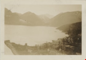
Britannia Beach at dark
https://search.heritageburnaby.ca/link/museumdescription19558
- Repository
- Burnaby Village Museum
- Date
- 1939
- Collection/Fonds
- Hawkshaw family fonds
- Description Level
- Item
- Physical Description
- 1 photograph : b&w ; 6.5 x 9 cm
- Scope and Content
- Photograph of Britannia Beach looking towards Howe Sound at dark.
- Repository
- Burnaby Village Museum
- Collection/Fonds
- Hawkshaw family fonds
- Description Level
- Item
- Physical Description
- 1 photograph : b&w ; 6.5 x 9 cm
- Scope and Content
- Photograph of Britannia Beach looking towards Howe Sound at dark.
- Subjects
- Geographic Features - Natural Geographic Features
- Geographic Features - Mountains
- Industries - Mining
- Accession Code
- BV996.6.265
- Access Restriction
- No restrictions
- Reproduction Restriction
- No known restrictions
- Date
- 1939
- Media Type
- Photograph
- Scan Date
- 2023-02-16
- Notes
- Title based on contents of photograph
- Caption beneath photograph reads: "At Dark"
- Caption on page of photograph album reads: "Spring / of / 1939"
- Photograph is part of photograph album BV996.6.1
Images
