Narrow Results By
Subject
- Advertising Medium 1
- Advertising Medium - Signs and Signboards 5
- Agricultural Tools and Equipment 1
- Agricultural Tools and Equipment - Gardening Equipment 3
- Agricultural Tools and Equipment - Plows 3
- Agriculture - Crops 3
- Agriculture - Farms 13
- Agriculture - Fruit and Berries 5
- Agriculture - Orchards 1
- Animals 1
- Animals - Cows 4
- Animals - Deer 1
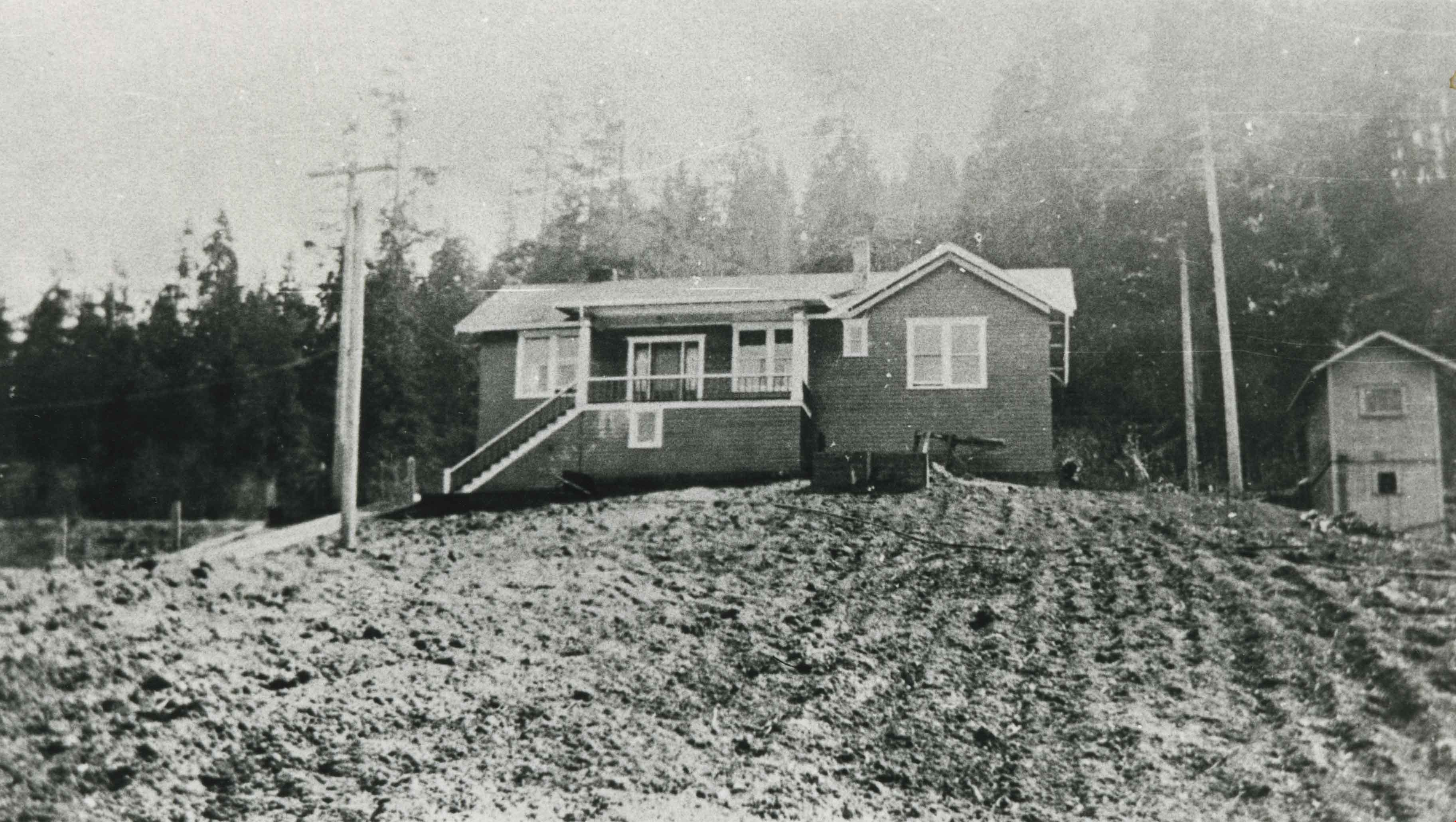
![Warren family home, [1915] (date of original), copied 1986 thumbnail](/media/hpo/_Data/_Archives_Images/_Unrestricted/204/204-333.jpg?width=280)
Warren family home
https://search.heritageburnaby.ca/link/archivedescription35475
- Repository
- City of Burnaby Archives
- Date
- [1915] (date of original), copied 1986
- Collection/Fonds
- Burnaby Historical Society fonds
- Description Level
- Item
- Physical Description
- 1 photograph : b&w ; 12.7 x 17.8 cm print
- Scope and Content
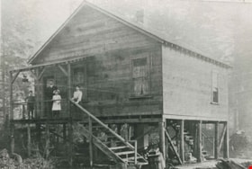
- Photograph of the Warren family home at 4264 Union Street, Vancouver Heights. Dubbed the "House that Jack Built," it was finished in 1912. The house was built by John H. Warren (Jack), and he settled there with his wife Mary W. Warren (nee Slaven) and their children, James Warren (Jim) and Mary War…
- Repository
- City of Burnaby Archives
- Date
- [1915] (date of original), copied 1986
- Collection/Fonds
- Burnaby Historical Society fonds
- Subseries
- Pioneer Tales subseries
- Physical Description
- 1 photograph : b&w ; 12.7 x 17.8 cm print
- Description Level
- Item
- Record No.
- 204-333
- Access Restriction
- No restrictions
- Reproduction Restriction
- No known restrictions
- Accession Number
- BHS1988-03
- Scope and Content
- Photograph of the Warren family home at 4264 Union Street, Vancouver Heights. Dubbed the "House that Jack Built," it was finished in 1912. The house was built by John H. Warren (Jack), and he settled there with his wife Mary W. Warren (nee Slaven) and their children, James Warren (Jim) and Mary Warren (later Mary Anthony).
- Subjects
- Buildings - Residential - Houses
- Media Type
- Photograph
- Notes
- Title based on contents of photograph
- Geographic Access
- Union Street
- Street Address
- 4264 Union Street
- Historic Neighbourhood
- Vancouver Heights (Historic Neighbourhood)
- Planning Study Area
- Willingdon Heights Area
Images
![Warren family home, [1915] (date of original), copied 1986 thumbnail](/media/hpo/_Data/_Archives_Images/_Unrestricted/204/204-333.jpg)
Warren family home
https://search.heritageburnaby.ca/link/archivedescription35538
- Repository
- City of Burnaby Archives
- Date
- 1912 (date of original), copied 1986
- Collection/Fonds
- Burnaby Historical Society fonds
- Description Level
- Item
- Physical Description
- 1 photograph : b&w ; 12.7 x 17.8 cm print
- Scope and Content
- Photograph of the Warren family home on Union Street, built by John "Jack" Warren (father of James Warren). The virgin-timbered land was cleared by the family first.
- Repository
- City of Burnaby Archives
- Date
- 1912 (date of original), copied 1986
- Collection/Fonds
- Burnaby Historical Society fonds
- Subseries
- Pioneer Tales subseries
- Physical Description
- 1 photograph : b&w ; 12.7 x 17.8 cm print
- Description Level
- Item
- Record No.
- 204-396
- Access Restriction
- No restrictions
- Reproduction Restriction
- No known restrictions
- Accession Number
- BHS1988-03
- Scope and Content
- Photograph of the Warren family home on Union Street, built by John "Jack" Warren (father of James Warren). The virgin-timbered land was cleared by the family first.
- Subjects
- Buildings - Residential - Houses
- Media Type
- Photograph
- Notes
- Title based on contents of photograph
- Geographic Access
- Union Street
- Historic Neighbourhood
- Vancouver Heights (Historic Neighbourhood)
- Planning Study Area
- Willingdon Heights Area
Images

![W.F. Silver house, [ca. 1912] (date of original), copied 1986 thumbnail](/media/hpo/_Data/_Archives_Images/_Unrestricted/126/173-001.jpg?width=280)
W.F. Silver house
https://search.heritageburnaby.ca/link/archivedescription35006
- Repository
- City of Burnaby Archives
- Date
- [ca. 1912] (date of original), copied 1986
- Collection/Fonds
- Burnaby Historical Society fonds
- Description Level
- Item
- Physical Description
- 1 photograph : b&w ; 8.8 x 12.5 cm print
- Scope and Content
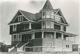
- Photograph of the exterior of the house of William F. Silver, Kingsway at Silver Avenue. An automobile, believed to be the family's 1911 Winton, is parked outside, and people are seated and standing on the right side of the photograph beside the house.
- Repository
- City of Burnaby Archives
- Date
- [ca. 1912] (date of original), copied 1986
- Collection/Fonds
- Burnaby Historical Society fonds
- Subseries
- Silver family subseries
- Physical Description
- 1 photograph : b&w ; 8.8 x 12.5 cm print
- Description Level
- Item
- Record No.
- 173-001
- Access Restriction
- No restrictions
- Reproduction Restriction
- No known restrictions
- Accession Number
- BHS1986-22
- Scope and Content
- Photograph of the exterior of the house of William F. Silver, Kingsway at Silver Avenue. An automobile, believed to be the family's 1911 Winton, is parked outside, and people are seated and standing on the right side of the photograph beside the house.
- Media Type
- Photograph
- Notes
- Title based on contents of photograph
- Geographic Access
- Kingsway
- Silver Avenue
- Historic Neighbourhood
- Central Park (Historic Neighbourhood)
- Planning Study Area
- Maywood Area
Images
![W.F. Silver house, [ca. 1912] (date of original), copied 1986 thumbnail](/media/hpo/_Data/_Archives_Images/_Unrestricted/126/173-001.jpg)
![Whyte family house, [1913 or 1914] thumbnail](/media/hpo/_Data/_Archives_Images/_Unrestricted/205/224-002.jpg?width=280)
Whyte family house
https://search.heritageburnaby.ca/link/archivedescription36133
- Repository
- City of Burnaby Archives
- Date
- [1913 or 1914]
- Collection/Fonds
- Burnaby Historical Society fonds
- Description Level
- Item
- Physical Description
- 1 photograph : sepia ; 13 x 18 cm, mounted on board 20 x 22 cm
- Scope and Content
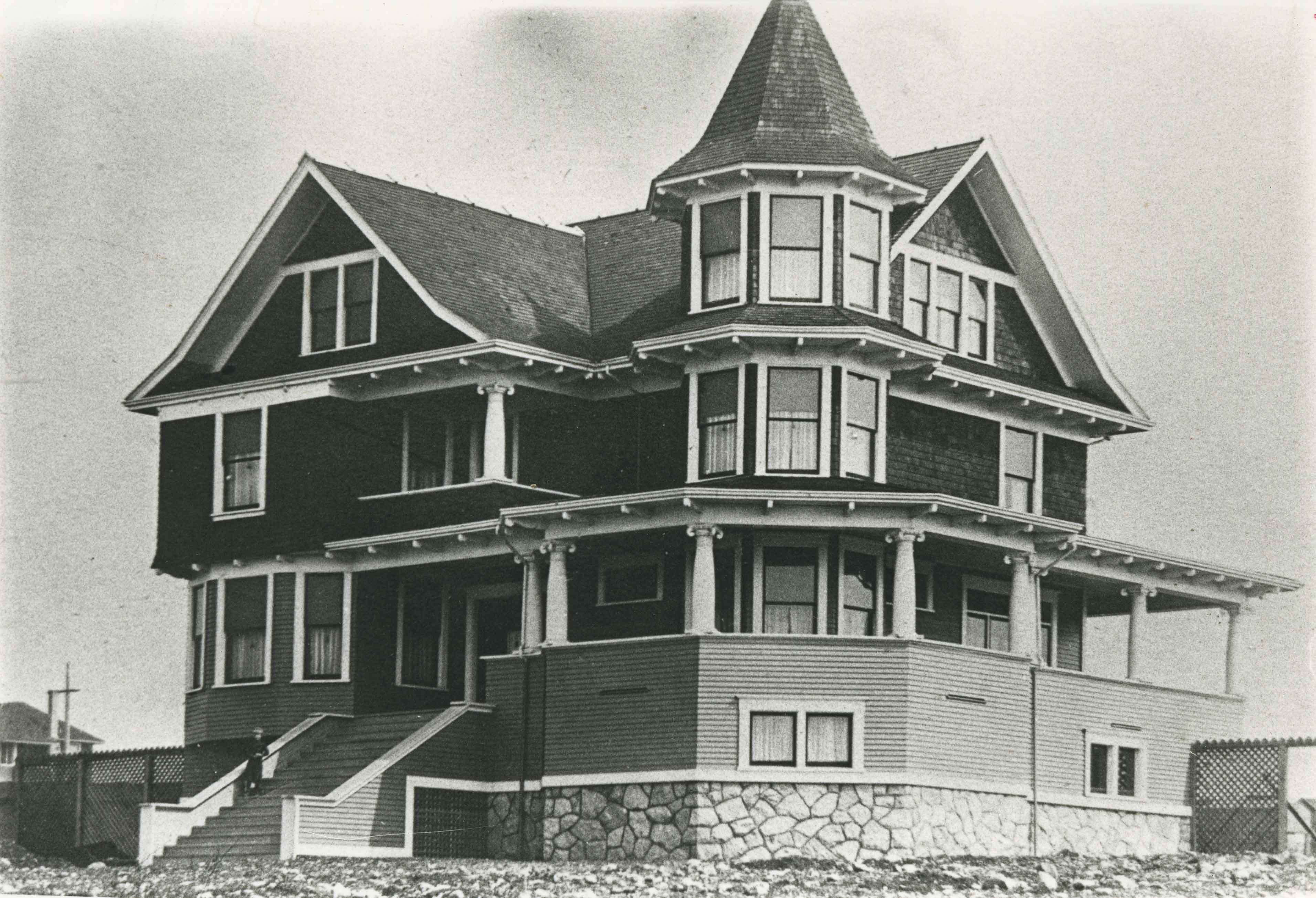
- Photograph of Mr. and Mrs. George Whyte on the porch of their home, believed to be on 17th Street.
- Repository
- City of Burnaby Archives
- Date
- [1913 or 1914]
- Collection/Fonds
- Burnaby Historical Society fonds
- Subseries
- Whyte family subseries
- Physical Description
- 1 photograph : sepia ; 13 x 18 cm, mounted on board 20 x 22 cm
- Description Level
- Item
- Record No.
- 224-002
- Access Restriction
- No restrictions
- Reproduction Restriction
- No known restrictions
- Accession Number
- BHS1989-21
- Scope and Content
- Photograph of Mr. and Mrs. George Whyte on the porch of their home, believed to be on 17th Street.
- Subjects
- Buildings - Residential - Houses
- Names
- Whyte, George
- Media Type
- Photograph
- Notes
- Title based on contents of photograph
- Geographic Access
- 17th Avenue
- Historic Neighbourhood
- Edmonds (Historic Neighbourhood)
- Planning Study Area
- Edmonds Area
Images
![Whyte family house, [1913 or 1914] thumbnail](/media/hpo/_Data/_Archives_Images/_Unrestricted/205/224-002.jpg)
Wilks family home
https://search.heritageburnaby.ca/link/archivedescription35440
- Repository
- City of Burnaby Archives
- Date
- 1915 (date of original), copied 1986
- Collection/Fonds
- Burnaby Historical Society fonds
- Description Level
- Item
- Physical Description
- 1 photograph : b&w ; 12.7 x 17.8 cm print
- Scope and Content
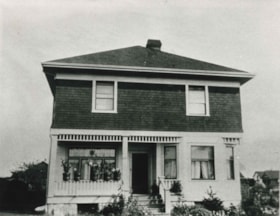
- Photograph of the Wilks family home at 3707 Dundas Street and Boundary Road. This house was one of the earliest built in Vancouver Heights and cost $5,000 to build. The Wilks family consisted of Arthur Wilks, his wife Annie Wilks, and their five children.
- Repository
- City of Burnaby Archives
- Date
- 1915 (date of original), copied 1986
- Collection/Fonds
- Burnaby Historical Society fonds
- Subseries
- Pioneer Tales subseries
- Physical Description
- 1 photograph : b&w ; 12.7 x 17.8 cm print
- Description Level
- Item
- Record No.
- 204-298
- Access Restriction
- No restrictions
- Reproduction Restriction
- No restrictions
- Accession Number
- BHS1988-03
- Scope and Content
- Photograph of the Wilks family home at 3707 Dundas Street and Boundary Road. This house was one of the earliest built in Vancouver Heights and cost $5,000 to build. The Wilks family consisted of Arthur Wilks, his wife Annie Wilks, and their five children.
- Subjects
- Buildings - Residential - Houses
- Media Type
- Photograph
- Photographer
- Eaton, Dr. Carl
- Notes
- Title based on contents of photograph
- Geographic Access
- Dundas Street
- Street Address
- 3707 Dundas Street
- Historic Neighbourhood
- Vancouver Heights (Historic Neighbourhood)
- Planning Study Area
- Burnaby Heights Area
Images
![William Brenchley house, [between 1890 and 1895] (date of original), copied 1985 thumbnail](/media/hpo/_Data/_Archives_Images/_Unrestricted/126/146-001.jpg?width=280)
William Brenchley house
https://search.heritageburnaby.ca/link/archivedescription34863
- Repository
- City of Burnaby Archives
- Date
- [between 1890 and 1895] (date of original), copied 1985
- Collection/Fonds
- Burnaby Historical Society fonds
- Description Level
- Item
- Physical Description
- 1 photograph : b&w ; 8.8 x 12.5 cm print
- Scope and Content
- Photograph of the exterior of the house of William Brenchley at 10th Avenue and Kingsway, northeast corner. A number of people are standing outside. Partially cleared land can be seen in the background.
- Repository
- City of Burnaby Archives
- Date
- [between 1890 and 1895] (date of original), copied 1985
- Collection/Fonds
- Burnaby Historical Society fonds
- Subseries
- W.E. Brenchley subseries
- Physical Description
- 1 photograph : b&w ; 8.8 x 12.5 cm print
- Description Level
- Item
- Record No.
- 146-001
- Access Restriction
- No restrictions
- Reproduction Restriction
- No known restrictions
- Accession Number
- BHS1985-16
- Scope and Content
- Photograph of the exterior of the house of William Brenchley at 10th Avenue and Kingsway, northeast corner. A number of people are standing outside. Partially cleared land can be seen in the background.
- Subjects
- Buildings - Residential - Houses
- Media Type
- Photograph
- Notes
- Title based on contents of photograph
- Geographic Access
- 10th Avenue
- Kingsway
- Historic Neighbourhood
- Edmonds (Historic Neighbourhood)
- Planning Study Area
- Edmonds Area
Images
![William Brenchley house, [between 1890 and 1895] (date of original), copied 1985 thumbnail](/media/hpo/_Data/_Archives_Images/_Unrestricted/126/146-001.jpg)
Wilson family home
https://search.heritageburnaby.ca/link/archivedescription35784
- Repository
- City of Burnaby Archives
- Date
- 1912 (date of original), copied 1986
- Collection/Fonds
- Burnaby Historical Society fonds
- Description Level
- Item
- Physical Description
- 1 photograph : b&w ; 12.7 x 17.8 cm print
- Scope and Content
- Photgraph of the Wilson family home at 3317 Wilson Avenue (later renumbered 6088 Wilson Avenue). This second home on Wilson Avenue was bigger than the family's first home on Westminster Road, with seven rooms.
- Repository
- City of Burnaby Archives
- Date
- 1912 (date of original), copied 1986
- Collection/Fonds
- Burnaby Historical Society fonds
- Subseries
- Pioneer Tales subseries
- Physical Description
- 1 photograph : b&w ; 12.7 x 17.8 cm print
- Description Level
- Item
- Record No.
- 204-642
- Access Restriction
- No restrictions
- Reproduction Restriction
- No known restrictions
- Accession Number
- BHS1988-03
- Scope and Content
- Photgraph of the Wilson family home at 3317 Wilson Avenue (later renumbered 6088 Wilson Avenue). This second home on Wilson Avenue was bigger than the family's first home on Westminster Road, with seven rooms.
- Subjects
- Buildings - Residential - Houses
- Media Type
- Photograph
- Notes
- Title based on contents of photograph
- Geographic Access
- Wilson Avenue
- Street Address
- 6088 Wilson Avenue
- Historic Neighbourhood
- Central Park (Historic Neighbourhood)
- Planning Study Area
- Maywood Area
Images


Woolsey family home
https://search.heritageburnaby.ca/link/archivedescription35636
- Repository
- City of Burnaby Archives
- Date
- 1917 (date of original), copied 1986
- Collection/Fonds
- Burnaby Historical Society fonds
- Description Level
- Item
- Physical Description
- 1 photograph : b&w ; 12.7 x 17.8 cm print
- Scope and Content
- Photograph of the Woolsey family home at 7790 Barnet Road, owned by Shell Oil Company. It was built by Robert Woolsey for use by the Shell marine depot superintendent, which was his position. The house is seen from the north, or waterfront, side.
- Repository
- City of Burnaby Archives
- Date
- 1917 (date of original), copied 1986
- Collection/Fonds
- Burnaby Historical Society fonds
- Subseries
- Pioneer Tales subseries
- Physical Description
- 1 photograph : b&w ; 12.7 x 17.8 cm print
- Description Level
- Item
- Record No.
- 204-494
- Access Restriction
- No restrictions
- Reproduction Restriction
- No known restrictions
- Accession Number
- BHS1988-03
- Scope and Content
- Photograph of the Woolsey family home at 7790 Barnet Road, owned by Shell Oil Company. It was built by Robert Woolsey for use by the Shell marine depot superintendent, which was his position. The house is seen from the north, or waterfront, side.
- Subjects
- Buildings - Residential - Houses
- Names
- Shell Oil Company
- Media Type
- Photograph
- Notes
- Title based on contents of photograph
- Geographic Access
- Barnet Road
- Street Address
- 7790 Barnet Road
- Historic Neighbourhood
- Barnet (Historic Neighbourhood)
- Planning Study Area
- Burnaby Mountain Area
Images
![Woolsey family home, [1917] (date of original), copied 1986 thumbnail](/media/hpo/_Data/_Archives_Images/_Unrestricted/204/204-495.jpg?width=280)
Woolsey family home
https://search.heritageburnaby.ca/link/archivedescription35637
- Repository
- City of Burnaby Archives
- Date
- [1917] (date of original), copied 1986
- Collection/Fonds
- Burnaby Historical Society fonds
- Description Level
- Item
- Physical Description
- 1 photograph : b&w ; 12.7 x 17.8 cm print
- Scope and Content
- Photograph of the Woolsey family home at 7790 Barnet Road as seen from the Barnet Road side. The house was not quite in Barnet Village, but close to it. The house was owned by the Shell Oil Company. It was built by Robert Woolsey for use by the Shell marine depot superintendent, which was his po…
- Repository
- City of Burnaby Archives
- Date
- [1917] (date of original), copied 1986
- Collection/Fonds
- Burnaby Historical Society fonds
- Subseries
- Pioneer Tales subseries
- Physical Description
- 1 photograph : b&w ; 12.7 x 17.8 cm print
- Description Level
- Item
- Record No.
- 204-495
- Access Restriction
- No restrictions
- Reproduction Restriction
- No known restrictions
- Accession Number
- BHS1988-03
- Scope and Content
- Photograph of the Woolsey family home at 7790 Barnet Road as seen from the Barnet Road side. The house was not quite in Barnet Village, but close to it. The house was owned by the Shell Oil Company. It was built by Robert Woolsey for use by the Shell marine depot superintendent, which was his position.
- Subjects
- Buildings - Residential - Houses
- Names
- Shell Oil Company
- Media Type
- Photograph
- Notes
- Title based on contents of photograph
- Geographic Access
- Barnet Road
- Street Address
- 7790 Barnet Road
- Historic Neighbourhood
- Barnet (Historic Neighbourhood)
- Planning Study Area
- Burnaby Mountain Area
Images
![Woolsey family home, [1917] (date of original), copied 1986 thumbnail](/media/hpo/_Data/_Archives_Images/_Unrestricted/204/204-495.jpg)

Yorston family home
https://search.heritageburnaby.ca/link/archivedescription35479
- Repository
- City of Burnaby Archives
- Date
- 1910 (date of original), copied 1986
- Collection/Fonds
- Burnaby Historical Society fonds
- Description Level
- Item
- Physical Description
- 1 photograph : b&w ; 12.7 x 17.8 cm print
- Scope and Content
- Photograph of the Yorston family home and Yorston real estate office at 4080 East Hastings (later 4050 Hastings Street), built in 1909. This was one of the first structures in Vancouver Heights on Hastings Street east of Boundary Road It was the home of Ernest A. Yorston, his wife Florence L. Yors…
- Repository
- City of Burnaby Archives
- Date
- 1910 (date of original), copied 1986
- Collection/Fonds
- Burnaby Historical Society fonds
- Subseries
- Pioneer Tales subseries
- Physical Description
- 1 photograph : b&w ; 12.7 x 17.8 cm print
- Description Level
- Item
- Record No.
- 204-337
- Access Restriction
- No restrictions
- Reproduction Restriction
- No known restrictions
- Accession Number
- BHS1988-03
- Scope and Content
- Photograph of the Yorston family home and Yorston real estate office at 4080 East Hastings (later 4050 Hastings Street), built in 1909. This was one of the first structures in Vancouver Heights on Hastings Street east of Boundary Road It was the home of Ernest A. Yorston, his wife Florence L. Yorston (nee Marston) and their children. The L.C. Tull furniture store can be seen in the background.
- Subjects
- Buildings - Residential - Houses
- Businesses - Real Estate Agencies
- Buildings - Commercial - Stores
- Names
- Yorston Real Estate
- Media Type
- Photograph
- Notes
- Title based on contents of photograph
- Geographic Access
- Hastings Street
- Street Address
- 4050 Hastings Street
- Historic Neighbourhood
- Vancouver Heights (Historic Neighbourhood)
- Planning Study Area
- Willingdon Heights Area
Images
