More like '7818 6th Street'
Narrow Results By
Decade
- 2020s 139
- 2010s 129
- 2000s 752
- 1990s 748
- 1980s 558
- 1970s 1365
- 1960s 473
- 1950s 749
- 1940s 891
- 1930s
- 1920s 895
- 1910s 814
- 1900s 349
- 1890s 49
- 1880s 71
- 1870s 5
- 1860s 3
- 1850s 2
- 1840s 1
- 1830s 1
- 1820s 1
- 1810s 1
- 1800s 1
- 1790s 1
- 1780s 1
- 1770s 1
- 1760s 1
- 1750s 1
- 1740s 1
- 1730s 1
- 1720s 1
- 1710s 1
- 1700s 1
- 1690s 1
- 1680s
- 1670s 1
- 1660s 1
- 1650s 1
- 1640s 1
- 1630s 1
- 1620s 1
- 1610s 1
- 1600s 1
- 1520s 1
Subject
- Accidents 4
- Accidents - Automobile Accidents 4
- Advertising Medium - Signs and Signboards 8
- Aerial Photographs 1
- Agricultural Tools and Equipment - Gardening Equipment 2
- Agricultural Tools and Equipment - Plows 1
- Agriculture 2
- Agriculture - Crops 2
- Agriculture - Dairy 1
- Agriculture - Farms 15
- Agriculture - Fruit and Berries 1
- Animals - Birds 2

Duncan & Margaret McGregor Estate 'Glen-Lyon' New Haven Barn
https://search.heritageburnaby.ca/link/landmark852
- Repository
- Burnaby Heritage Planning
- Description
- Designed in a vernacular architectural style, the New Haven Barn is a large gambrel-roofed barn located on the Edwardian era McGregor Estate 'Glen-Lyon,' overlooking the rich farmland of the Fraser River floodplain and near a ravine and forested area adjacent to Marine Drive in South Burnaby.
- Associated Dates
- 1939
- Formal Recognition
- Heritage Designation, Community Heritage Register
- Other Names
- Home of the Friendless, New Haven Borstal Home for Boys and Youthful Offenders, New Haven Correction Centre
- Street View URL
- Google Maps Street View
- Repository
- Burnaby Heritage Planning
- Other Names
- Home of the Friendless, New Haven Borstal Home for Boys and Youthful Offenders, New Haven Correction Centre
- Geographic Access
- Marine Drive
- Associated Dates
- 1939
- Formal Recognition
- Heritage Designation, Community Heritage Register
- Enactment Type
- Bylaw No. 12183
- Enactment Date
- 11/12/2006
- Description
- Designed in a vernacular architectural style, the New Haven Barn is a large gambrel-roofed barn located on the Edwardian era McGregor Estate 'Glen-Lyon,' overlooking the rich farmland of the Fraser River floodplain and near a ravine and forested area adjacent to Marine Drive in South Burnaby.
- Heritage Value
- The site is historically significant for its association with early social welfare and correctional reform. The estate was sold in 1926 to an inter-denominational religious organization called the Home of the Friendless, which used it as their B.C. headquarters. The organization was charged with several cases of abuse and neglect in 1937, after which a Royal Commission was formed that led to new legislation to regulate and license all private welfare institutions. 'Glen-Lyon' was sold to the provincial government, and was dedicated in 1939 by the Lt.-Gov. E.W. Hamber for use as the New Haven Borstal Home for Boys and Youthful Offenders (later renamed the New Haven Correction Centre). The Borstal movement originated in England in the late nineteenth century, as an alternative to sending young offenders and runaways to prisons by providing reformatories that focused on discipline and vocational skill. This site’s role as the first North American institution devoted to the Borstal School philosophy was historic, and influenced corrections programs across Canada. The New Haven Barn is a significant feature from its development in 1939 as the Borstal School, designed by Chief Provincial Architect Henry Whittaker of the Department of Public Works, and is the only remaining structure of its kind in Burnaby.
- Defining Elements
- Key elements that define the heritage character of the New Haven Barn include its: - gambrel-roofed barn with roof vent with finial, sliding hay loft and access doors, small multi-pane windows, and lapped wooden siding
- Historic Neighbourhood
- Fraser Arm (Historic Neighbourhood)
- Planning Study Area
- Big Bend Area
- Architect
- Henry Whittaker
- Function
- Primary Historic--Estate
- Community
- Burnaby
- Cadastral Identifier
- 003-004-661
- Boundaries
- 'Glen-Lyon' is comprised of a single residential lot located at 4250 Marine Drive, Burnaby.
- Area
- 230873.18
- Contributing Resource
- Building
- Ownership
- Private
- Names
- Whittaker, George
- New Haven Borstal Home for Boys and Youthful Offenders
- New Haven Correction Centre
- Borstal School
- Street Address
- 4250 Marine Drive
- Street View URL
- Google Maps Street View
Images


![1935 Ford in the Snow, [193-?] (date of original), copied 1992 thumbnail](/media/hpo/_Data/_Archives_Images/_Unrestricted/315/315-373.jpg?width=280)
1935 Ford in the Snow
https://search.heritageburnaby.ca/link/archivedescription36915
- Repository
- City of Burnaby Archives
- Date
- [193-?] (date of original), copied 1992
- Collection/Fonds
- Burnaby Historical Society fonds
- Description Level
- Item
- Physical Description
- 1 photograph : b&w ; 8.8 x 12.7 cm print
- Scope and Content
- Photograph of a 1935 Ford beside a snow bank.
- Repository
- City of Burnaby Archives
- Date
- [193-?] (date of original), copied 1992
- Collection/Fonds
- Burnaby Historical Society fonds
- Subseries
- Burnaby Centennial Anthology subseries
- Physical Description
- 1 photograph : b&w ; 8.8 x 12.7 cm print
- Description Level
- Item
- Record No.
- 315-373
- Access Restriction
- No restrictions
- Reproduction Restriction
- No known restrictions
- Accession Number
- BHS1994-04
- Scope and Content
- Photograph of a 1935 Ford beside a snow bank.
- Media Type
- Photograph
- Notes
- Title based on contents of photograph
Images
![1935 Ford in the Snow, [193-?] (date of original), copied 1992 thumbnail](/media/hpo/_Data/_Archives_Images/_Unrestricted/315/315-373.jpg)
![Alice and David Norman seated on front of automobile, [between 1925 and 1935] thumbnail](/media/hpo/_Data/_BVM_Images/2023/2023_0015_0006_001.jpg?width=280)
Alice and David Norman seated on front of automobile
https://search.heritageburnaby.ca/link/museumdescription20280
- Repository
- Burnaby Village Museum
- Date
- [between 1925 and 1935]
- Collection/Fonds
- Burnaby Village Museum Photograph collection
- Description Level
- Item
- Physical Description
- 1 photograph : b&w negative ; 12.5 x 10 cm
- Scope and Content
- Photograph of Alice Victoria (Goodridge) Norman and her husband David Augustus Norman seated on the front of a Model 'T" Ford motor automobile outside of the Goodridge grocery store on located at 4835 Hastings Street in Burnaby.
- Repository
- Burnaby Village Museum
- Collection/Fonds
- Burnaby Village Museum Photograph collection
- Description Level
- Item
- Physical Description
- 1 photograph : b&w negative ; 12.5 x 10 cm
- Scope and Content
- Photograph of Alice Victoria (Goodridge) Norman and her husband David Augustus Norman seated on the front of a Model 'T" Ford motor automobile outside of the Goodridge grocery store on located at 4835 Hastings Street in Burnaby.
- Subjects
- Buildings - Commercial
- Buildings - Commercial - Grocery Stores
- Transportation - Automobiles
- Accession Code
- BV023.15.6
- Access Restriction
- No restrictions
- Reproduction Restriction
- No known restrictions
- Date
- [between 1925 and 1935]
- Media Type
- Photograph
- Scan Resolution
- 3200
- Scan Date
- 2023-09-21
- Notes
- Title based on contents of photograph
- 1 b&w contact sheet accompanying
Images
![Alice and David Norman seated on front of automobile, [between 1925 and 1935] thumbnail](/media/hpo/_Data/_BVM_Images/2023/2023_0015_0006_001.jpg)
![Alice Norman and Bill Goodridge seated on front of automobile, [between 1925 and 1935] thumbnail](/media/hpo/_Data/_BVM_Images/2023/2023_0015_0005_001.jpg?width=280)
Alice Norman and Bill Goodridge seated on front of automobile
https://search.heritageburnaby.ca/link/museumdescription20279
- Repository
- Burnaby Village Museum
- Date
- [between 1925 and 1935]
- Collection/Fonds
- Burnaby Village Museum Photograph collection
- Description Level
- Item
- Physical Description
- 1 photograph : b&w negative ; 12.5 x 10 cm
- Scope and Content
- Photograph of Alice Victoria (Goodridge) Norman and her brother William "Bill" Goodridge seated on the front of a Model 'T" Ford motor automobile outside of the Goodridge grocery store located at 4835 Hastings Street in Burnaby.
- Repository
- Burnaby Village Museum
- Collection/Fonds
- Burnaby Village Museum Photograph collection
- Description Level
- Item
- Physical Description
- 1 photograph : b&w negative ; 12.5 x 10 cm
- Scope and Content
- Photograph of Alice Victoria (Goodridge) Norman and her brother William "Bill" Goodridge seated on the front of a Model 'T" Ford motor automobile outside of the Goodridge grocery store located at 4835 Hastings Street in Burnaby.
- Subjects
- Buildings - Commercial
- Buildings - Commercial - Grocery Stores
- Transportation - Automobiles
- Accession Code
- BV023.15.5
- Access Restriction
- No restrictions
- Reproduction Restriction
- No known restrictions
- Date
- [between 1925 and 1935]
- Media Type
- Photograph
- Scan Resolution
- 3200
- Scan Date
- 2023-09-21
- Notes
- Title based on contents of photograph
- 1 b&w contact sheet accompanying
Images
![Alice Norman and Bill Goodridge seated on front of automobile, [between 1925 and 1935] thumbnail](/media/hpo/_Data/_BVM_Images/2023/2023_0015_0005_001.jpg)

Streetcar snowplough
https://search.heritageburnaby.ca/link/archivedescription37620
- Repository
- City of Burnaby Archives
- Date
- 1937 (date of original), copied 1991
- Collection/Fonds
- Burnaby Historical Society fonds
- Description Level
- Item
- Physical Description
- 1 photograph : b&w ; 2.9 x 4.4 cm print on contact sheet 20.2 x 25.3 cm
- Scope and Content
- Photograph of a streetcar fitted with a snowplough at the corner of Gilmore Avenue and Hastings Street in the snow.
- Repository
- City of Burnaby Archives
- Date
- 1937 (date of original), copied 1991
- Collection/Fonds
- Burnaby Historical Society fonds
- Subseries
- Burnaby Image Bank subseries
- Physical Description
- 1 photograph : b&w ; 2.9 x 4.4 cm print on contact sheet 20.2 x 25.3 cm
- Description Level
- Item
- Record No.
- 370-208
- Access Restriction
- No restrictions
- Reproduction Restriction
- No known restrictions
- Accession Number
- BHS1999-03
- Scope and Content
- Photograph of a streetcar fitted with a snowplough at the corner of Gilmore Avenue and Hastings Street in the snow.
- Subjects
- Transportation - Electric Railroads
- Transportation - Snowploughs
- Geographic Features - Roads
- Media Type
- Photograph
- Notes
- Title based on contents of photograph
- 1 b&w copy negative accompanying
- Geographic Access
- Gilmore Avenue
- Hastings Street
- Historic Neighbourhood
- Vancouver Heights (Historic Neighbourhood)
Images

![Stanley family on road in Fraser Canyon, [193-] thumbnail](/media/hpo/_Data/_BVM_Images/2022/2022_0032_0603_001.jpg?width=280)
Stanley family on road in Fraser Canyon
https://search.heritageburnaby.ca/link/museumdescription20181
- Repository
- Burnaby Village Museum
- Date
- [193-]
- Collection/Fonds
- Esther Love Stanley fonds
- Description Level
- Item
- Physical Description
- 1 photograph : b&w ; 9 x 6 cm
- Scope and Content
- Photograph of members of the Stanley family posing with automobile on roadside outside of a tunnel carved out rock face. Young Joyce (Stanley) Warner is seated on the hood of the car, Frank "Stan" Stanley is leaning against the hood of the car and his other children Mary (Stanley) Pearson (left), F…
- Repository
- Burnaby Village Museum
- Collection/Fonds
- Esther Love Stanley fonds
- Description Level
- Item
- Physical Description
- 1 photograph : b&w ; 9 x 6 cm
- Scope and Content
- Photograph of members of the Stanley family posing with automobile on roadside outside of a tunnel carved out rock face. Young Joyce (Stanley) Warner is seated on the hood of the car, Frank "Stan" Stanley is leaning against the hood of the car and his other children Mary (Stanley) Pearson (left), Frank Stanley (middle) and Ina (Stanley) Shankie are seated on the front bumper. The family are on a road trip through the Fraser Canyon.
- Subjects
- Geographic Features - Roads
- Geographic Features - Rock Formations
- Geographic Features - Tunnels
- Names
- Stanley Family
- Stanley, Frank Charles "Stan", 1891-1975
- Stanley, Frank Conquest
- Shankie, Ina Esther Stanley
- Warner, Joyce Stanley
- Pearson, Mary Frances Stanley
- Accession Code
- BV022.32.603
- Access Restriction
- No restrictions
- Reproduction Restriction
- No known restrictions
- Date
- [193-]
- Media Type
- Photograph
- Scan Resolution
- 600
- Scan Date
- 2023-08-22
- Notes
- Title based on contents of photograph
- Photograph is part of Esther Love Stanley photograph album 2 (BV032.22.431)
- Note in black ink on verso of photograph reads: "JOYCE, STAN / MARY, FRANK, INA / FRASER CANYON"
- Note in white ink on album page reads: "JOYCE, STAN / MARY, FRANK, INA"
- Circular stamp on verso of photograph reads: "SPARKLETONE_PRINTS_WILL_NOT_FADE"
Images
![Stanley family on road in Fraser Canyon, [193-] thumbnail](/media/hpo/_Data/_BVM_Images/2022/2022_0032_0603_001.jpg)
![Snowplough on Barkerville Highway, [1938] thumbnail](/media/hpo/_Data/_Archives_Images/_Unrestricted/001/020-155.jpg?width=280)
Snowplough on Barkerville Highway
https://search.heritageburnaby.ca/link/archivedescription34448
- Repository
- City of Burnaby Archives
- Date
- [1938]
- Collection/Fonds
- Burnaby Historical Society fonds
- Description Level
- Item
- Physical Description
- 1 photograph : b&w ; 13.9 x 18.9 cm on page 17.5 x 26 cm
- Scope and Content
- Photograph has the following caption: "First rotary snowplough working on Barkerville Highway, Devil's Canyon."
- Repository
- City of Burnaby Archives
- Date
- [1938]
- Collection/Fonds
- Burnaby Historical Society fonds
- Subseries
- Peers family subseries
- Physical Description
- 1 photograph : b&w ; 13.9 x 18.9 cm on page 17.5 x 26 cm
- Description Level
- Item
- Record No.
- 020-155
- Access Restriction
- No restrictions
- Reproduction Restriction
- No known restrictions
- Accession Number
- BHS2007-04
- Scope and Content
- Photograph has the following caption: "First rotary snowplough working on Barkerville Highway, Devil's Canyon."
- Media Type
- Photograph
- Notes
- Title based on caption accompanying photograph
Images
![Snowplough on Barkerville Highway, [1938] thumbnail](/media/hpo/_Data/_Archives_Images/_Unrestricted/001/020-155.jpg)
![Eva and Jack standing under awning, [1936] thumbnail](/media/hpo/_Data/_BVM_Images/1996/1996_0006_0100_001.jpg?width=280)
Eva and Jack standing under awning
https://search.heritageburnaby.ca/link/museumdescription19416
- Repository
- Burnaby Village Museum
- Date
- [1936]
- Collection/Fonds
- Hawkshaw family fonds
- Description Level
- Item
- Physical Description
- 1 photograph : sepia ; 6.5 x 9 cm
- Scope and Content
- Photograph of a man and woman identified as Elva and Jack standing under an awning outside of a store or restaurant on an unidentified street. Cars are parked at an angle along the street in front of the buildings.
- Repository
- Burnaby Village Museum
- Collection/Fonds
- Hawkshaw family fonds
- Description Level
- Item
- Physical Description
- 1 photograph : sepia ; 6.5 x 9 cm
- Scope and Content
- Photograph of a man and woman identified as Elva and Jack standing under an awning outside of a store or restaurant on an unidentified street. Cars are parked at an angle along the street in front of the buildings.
- Accession Code
- BV996.6.100
- Access Restriction
- No restrictions
- Reproduction Restriction
- No known restrictions
- Date
- [1936]
- Media Type
- Photograph
- Scan Resolution
- 600
- Scan Date
- 2023-02-06
- Notes
- Title based on contents of photograph
- Caption beneath photograph reads: "Elva & Jack" / Pictures taken - here and there at / Sunday times"
- Photograph is part of photograph album BV996.6.1
Images
![Eva and Jack standing under awning, [1936] thumbnail](/media/hpo/_Data/_BVM_Images/1996/1996_0006_0100_001.jpg)
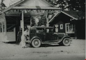
Oasis Gas Station
https://search.heritageburnaby.ca/link/archivedescription35628
- Repository
- City of Burnaby Archives
- Date
- 1935 (date of original), copied 1986
- Collection/Fonds
- Burnaby Historical Society fonds
- Description Level
- Item
- Physical Description
- 1 photograph : b&w ; 12.7 x 17.8 cm print
- Scope and Content
- Photograph of The Oasis gas station, leased by the Raymer family for the first 5 years, then taken over by the Raymers. Roy Raymer is shown pumping gas. The Oasis was located at 2675 Kingsway (Pacific Highway). It was later renumbered 6105 Kingsway.
- Repository
- City of Burnaby Archives
- Date
- 1935 (date of original), copied 1986
- Collection/Fonds
- Burnaby Historical Society fonds
- Subseries
- Pioneer Tales subseries
- Physical Description
- 1 photograph : b&w ; 12.7 x 17.8 cm print
- Description Level
- Item
- Record No.
- 204-486
- Access Restriction
- No restrictions
- Reproduction Restriction
- No known restrictions
- Accession Number
- BHS1988-03
- Scope and Content
- Photograph of The Oasis gas station, leased by the Raymer family for the first 5 years, then taken over by the Raymers. Roy Raymer is shown pumping gas. The Oasis was located at 2675 Kingsway (Pacific Highway). It was later renumbered 6105 Kingsway.
- Names
- Oasis
- Raymer, Roy
- Media Type
- Photograph
- Notes
- Title based on contents of photograph
- Geographic Access
- Kingsway
- Street Address
- 6105 Kingsway
- Planning Study Area
- Windsor Area
Images

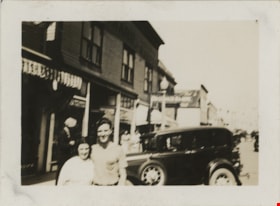
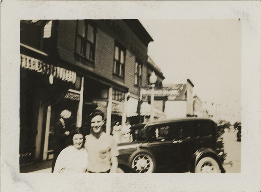
Ruby and Crichton in Chilliwack
https://search.heritageburnaby.ca/link/museumdescription19415
- Repository
- Burnaby Village Museum
- Date
- 1 Jul. 1936
- Collection/Fonds
- Hawkshaw family fonds
- Description Level
- Item
- Physical Description
- 1 photograph : sepia ; 6.5 x 9 cm
- Scope and Content
- Photograph of Crichton Hawkshaw (right) standing together with a woman named Ruby outside store fronts on a street in Chilliwack. There is an automobile parked on the street behind the couple.
- Repository
- Burnaby Village Museum
- Collection/Fonds
- Hawkshaw family fonds
- Description Level
- Item
- Physical Description
- 1 photograph : sepia ; 6.5 x 9 cm
- Material Details
- Image is blurry
- Scope and Content
- Photograph of Crichton Hawkshaw (right) standing together with a woman named Ruby outside store fronts on a street in Chilliwack. There is an automobile parked on the street behind the couple.
- Accession Code
- BV996.6.99
- Access Restriction
- No restrictions
- Reproduction Restriction
- No known restrictions
- Date
- 1 Jul. 1936
- Media Type
- Photograph
- Scan Resolution
- 600
- Scan Date
- 2023-02-06
- Notes
- Title based on contents of photograph
- Caption beneath photograph reads: "Ruby & I Chilliwack / July 1/36" / Pictures taken - here and there at / Sunday times"
- Photograph is part of photograph album BV996.6.1
Images

Rumble Street
https://search.heritageburnaby.ca/link/archivedescription34255
- Repository
- City of Burnaby Archives
- Date
- 1932
- Collection/Fonds
- Burnaby Historical Society fonds
- Description Level
- Item
- Physical Description
- 1 photograph : b&w ; 12.2 x 17.7 cm
- Scope and Content
- Photograph of Rumble Street looking east toward Patterson Avenue, located where the house on the left can be seen.
- Repository
- City of Burnaby Archives
- Date
- 1932
- Collection/Fonds
- Burnaby Historical Society fonds
- Subseries
- Photographs subseries
- Physical Description
- 1 photograph : b&w ; 12.2 x 17.7 cm
- Description Level
- Item
- Record No.
- 011-002
- Access Restriction
- No restrictions
- Reproduction Restriction
- No known restrictions
- Accession Number
- BHS2007-04
- Scope and Content
- Photograph of Rumble Street looking east toward Patterson Avenue, located where the house on the left can be seen.
- Media Type
- Photograph
- Notes
- Title based on contents of photograph
- Annotation at bottom of Copy 2 reads, "Rumble St. just after Municipal dump was filled / Facing east house on left is where Patterson Avenue [is]"
- Geographic Access
- Rumble Street
- Patterson Avenue
- Historic Neighbourhood
- Alta-Vista (Historic Neighbourhood)
- Planning Study Area
- Sussex-Nelson Area
- Suncrest Area
Images


Boat coming through locks
https://search.heritageburnaby.ca/link/museumdescription19435
- Repository
- Burnaby Village Museum
- Date
- 11 Oct. 1936
- Collection/Fonds
- Hawkshaw family fonds
- Description Level
- Item
- Physical Description
- 1 photograph : sepia ; 6.5 x 9 cm
- Scope and Content
- Photograph of a boat towing a log boom and coming through the Hiram M. Chittenden Locks (Ballard Locks) in Salmon Bay in Seattle, Washington's Ship Canal. The locks link Lake Washington to Puget Sound. The Salmon Bay Bridge is visible in the background spanning Salmon Bay.
- Repository
- Burnaby Village Museum
- Collection/Fonds
- Hawkshaw family fonds
- Description Level
- Item
- Physical Description
- 1 photograph : sepia ; 6.5 x 9 cm
- Scope and Content
- Photograph of a boat towing a log boom and coming through the Hiram M. Chittenden Locks (Ballard Locks) in Salmon Bay in Seattle, Washington's Ship Canal. The locks link Lake Washington to Puget Sound. The Salmon Bay Bridge is visible in the background spanning Salmon Bay.
- Subjects
- Transportation - Boats
- Geographic Features - Natural Waterways
- Geographic Features - Channels
- Geographic Features - Bays
- Structures - Bridges
- Water Control
- Accession Code
- BV996.6.119
- Access Restriction
- No restrictions
- Reproduction Restriction
- No known restrictions
- Date
- 11 Oct. 1936
- Media Type
- Photograph
- Scan Resolution
- 600
- Scan Date
- 2023-02-06
- Notes
- Title based on contents of photograph
- Caption beneath photograph reads: "COMING IN"
- Caption of album page reads: "Oct 11/36 / THANKSGIVING / SEATTLE"
- Photograph is part of photograph album BV996.6.1
Images

![Common Good Co-op Store, [1938] thumbnail](/media/hpo/_Data/_BVM_Images/1976/1976_0046_0001_001.jpg?width=280)
Common Good Co-op Store
https://search.heritageburnaby.ca/link/museumdescription735
- Repository
- Burnaby Village Museum
- Date
- [1938]
- Collection/Fonds
- Burnaby Village Museum Photograph collection
- Description Level
- Item
- Physical Description
- 1 photograph : sepia ; 6.8 x 11.2 cm
- Scope and Content
- Photograph of a man in an apron standing in front of a co-op store bearing the sign "C.G. Co-operative Association", otherwise known as the Army of the Common Good. Window displays include the goods he carries and advertising signs for Coca-Cola and Orange Crush are put up below the windows. In fro…
- Repository
- Burnaby Village Museum
- Collection/Fonds
- Burnaby Village Museum Photograph collection
- Description Level
- Item
- Physical Description
- 1 photograph : sepia ; 6.8 x 11.2 cm
- Material Details
- Inscribed in pencil, recto, b. "Co op store Douglas R." and in blue ink, verso, t. "Coop Store Douglas Road/ C.G. Co-op 1939", b. "Mr Love Mayor of/ store/ no 2", in blue ball point pen, l.l. "Main Store was at McKay station/ this is No 1 Branch store" stamped on verso, c. "VANCOUVER/ DRUG CO. LTD/ SEP 12 1938/ Nu-Gloss"
- Scope and Content
- Photograph of a man in an apron standing in front of a co-op store bearing the sign "C.G. Co-operative Association", otherwise known as the Army of the Common Good. Window displays include the goods he carries and advertising signs for Coca-Cola and Orange Crush are put up below the windows. In front of the store is wood plank sidewalk.
- Geographic Access
- Douglas Road
- Accession Code
- HV976.46.1
- Access Restriction
- No restrictions
- Reproduction Restriction
- No known restrictions
- Date
- [1938]
- Media Type
- Photograph
- Scan Resolution
- 600
- Scan Date
- 2023-06-20
- Notes
- Title based on caption of photograph
Images
![Common Good Co-op Store, [1938] thumbnail](/media/hpo/_Data/_BVM_Images/1976/1976_0046_0001_001.jpg)
![Harrison Hotel Club House, [between 1935 and 1940] thumbnail](/media/hpo/_Data/_Archives_Images/_Unrestricted/371/428-009.jpg?width=280)
Harrison Hotel Club House
https://search.heritageburnaby.ca/link/archivedescription65749
- Repository
- City of Burnaby Archives
- Date
- [between 1935 and 1940]
- Collection/Fonds
- Burnaby Historical Society fonds
- Description Level
- Item
- Physical Description
- 1 photograph : b&w hand-tinted into col. ; 16.5 x 24 cm [sight] matted in frame 24.5 x 32 cm
- Scope and Content
- Photograph of the 'Harrison Hotel Club House' believed to be in the village of Harrison Hot Springs, British Columbia.
- Repository
- City of Burnaby Archives
- Date
- [between 1935 and 1940]
- Collection/Fonds
- Burnaby Historical Society fonds
- Subseries
- Ettinger family subseries
- Physical Description
- 1 photograph : b&w hand-tinted into col. ; 16.5 x 24 cm [sight] matted in frame 24.5 x 32 cm
- Description Level
- Item
- Record No.
- 428-009
- Access Restriction
- No restrictions
- Reproduction Restriction
- No known restrictions
- Accession Number
- BHS2002-03
- Scope and Content
- Photograph of the 'Harrison Hotel Club House' believed to be in the village of Harrison Hot Springs, British Columbia.
- Subjects
- Structures - Bridges
- Geographic Features - Rivers
- Buildings - Commercial - Hotels and Motels
- Media Type
- Photograph
- Notes
- Title taken from note on verso of frame
- Note on verso of frame reads: "Harrison Hotel / Club House"
- 1 reference photograph accompanying
- Note on verso of reference photograph reads: "Harrison / Club House / approx 1935-40"
- 'Edmonds Studios' as possible photographer
Images
![Harrison Hotel Club House, [between 1935 and 1940] thumbnail](/media/hpo/_Data/_Archives_Images/_Unrestricted/371/428-009.jpg)
![Capitol Hill, [193-] (date of original), copied 1986 thumbnail](/media/hpo/_Data/_Archives_Images/_Unrestricted/126/189-001.jpg?width=280)
Capitol Hill
https://search.heritageburnaby.ca/link/archivedescription35080
- Repository
- City of Burnaby Archives
- Date
- [193-] (date of original), copied 1986
- Collection/Fonds
- Burnaby Historical Society fonds
- Description Level
- Item
- Physical Description
- 1 photograph : b&w ; 10.0 x 15.2 cm print
- Scope and Content
- Photograph of a logging road on the north face of Capitol Hill. Burrard Inlet can be seen in the background. An annotation in the photograph register describes it as a "road cut to take timber on side hill for destitute family's heat and cooking."
- Repository
- City of Burnaby Archives
- Date
- [193-] (date of original), copied 1986
- Collection/Fonds
- Burnaby Historical Society fonds
- Subseries
- Marjorie Coe subseries
- Physical Description
- 1 photograph : b&w ; 10.0 x 15.2 cm print
- Description Level
- Item
- Record No.
- 189-001
- Access Restriction
- No restrictions
- Reproduction Restriction
- No known restrictions
- Accession Number
- BHS1986-40
- Scope and Content
- Photograph of a logging road on the north face of Capitol Hill. Burrard Inlet can be seen in the background. An annotation in the photograph register describes it as a "road cut to take timber on side hill for destitute family's heat and cooking."
- Subjects
- Geographic Features - Roads
- Land Clearing
- Media Type
- Photograph
- Notes
- Title based on contents of photograph
- Historic Neighbourhood
- Capitol Hill (Historic Neighbourhood)
- Planning Study Area
- Capitol Hill Area
Images
![Capitol Hill, [193-] (date of original), copied 1986 thumbnail](/media/hpo/_Data/_Archives_Images/_Unrestricted/126/189-001.jpg)
![Copy of Official British Columbia Road Maps, [193-] thumbnail](/media/hpo/_Data/_BVM_Cartographic_Material/1972/1972_0179_0001_001.jpg?width=280)
Copy of Official British Columbia Road Maps
https://search.heritageburnaby.ca/link/museumdescription18945
- Repository
- Burnaby Village Museum
- Date
- [193-]
- Collection/Fonds
- Burnaby Village Museum Map collection
- Physical Description
- 1 map : lithographic print on sheet ; 43 x 56 cm folded to 22 x 11 cm
- Scope and Content
- Item consists of Road maps of British Columbia presented by Union Oil Company of Canada Limited. Includes seventeen maps printed on both sides of sheet. One side of sheet includes ten separate road maps titled "Cariboo"; "Chilcotin Plateau"; "150 Mile House to Prince George"; "Prince George - Burns…
- Repository
- Burnaby Village Museum
- Collection/Fonds
- Burnaby Village Museum Map collection
- Physical Description
- 1 map : lithographic print on sheet ; 43 x 56 cm folded to 22 x 11 cm
- Material Details
- Scale not defined
- Scope and Content
- Item consists of Road maps of British Columbia presented by Union Oil Company of Canada Limited. Includes seventeen maps printed on both sides of sheet. One side of sheet includes ten separate road maps titled "Cariboo"; "Chilcotin Plateau"; "150 Mile House to Prince George"; "Prince George - Burns Lake"; "Burns Lake - Hazelton"; "Similkameen - Nicola"; "Salmon Arm to Revelstoke"; "Ashcroft to Salmon Arm / Kamloops to Vernon"; "Okanagan Valley"; "Boundary District". Other side of sheet includes seven road maps titled "Vancouver Island"; "Vancouver to Yale"' "Fraser Canyon Section Cariboo Road"; "Lytton to 150 Mile House"; "Arrow and Kootenay Lakes"; "The Kootenays"; "Columbia Valley". When folded, cover of maps reads "COPY OF / OFFICIAL / BRITISH COLUMBIA / ROAD-MAPS" / Presented by / UNION OIL / COMPANY / of Canada Ltd."; verso of cover includes advertisement for Union Motor oil "MOTORITE"; inside cover includes advertisement for Union Gasoline with title reading "See Canada's Evergreen Playground".
- Responsibility
- Union Oil Company of Canada Limited
- Accession Code
- HV972.179.1
- Access Restriction
- No restrictions
- Reproduction Restriction
- No known restrictions
- Date
- [193-]
- Media Type
- Cartographic Material
- Scan Resolution
- 600
- Scan Date
- 2023-08-17
- Notes
- Title based on contents of map
Images
![Copy of Official British Columbia Road Maps, [193-] thumbnail](/media/hpo/_Data/_BVM_Cartographic_Material/1972/1972_0179_0001_001.jpg)

![Dog on Elgin Avenue, [1939] (date of original), copied 1986 thumbnail](/media/hpo/_Data/_Archives_Images/_Unrestricted/126/179-002.jpg?width=280)
Dog on Elgin Avenue
https://search.heritageburnaby.ca/link/archivedescription35031
- Repository
- City of Burnaby Archives
- Date
- [1939] (date of original), copied 1986
- Collection/Fonds
- Burnaby Historical Society fonds
- Description Level
- Item
- Physical Description
- 1 photograph : b&w ; 8.8 x 12.6 cm print
- Scope and Content
- Photograph of Elgin Avenue looking north. A dog is sitting in the middle of the road.
- Repository
- City of Burnaby Archives
- Date
- [1939] (date of original), copied 1986
- Collection/Fonds
- Burnaby Historical Society fonds
- Subseries
- Chamberlain family subseries
- Physical Description
- 1 photograph : b&w ; 8.8 x 12.6 cm print
- Description Level
- Item
- Record No.
- 179-002
- Access Restriction
- No restrictions
- Reproduction Restriction
- No known restrictions
- Accession Number
- BHS1986-27
- Scope and Content
- Photograph of Elgin Avenue looking north. A dog is sitting in the middle of the road.
- Media Type
- Photograph
- Notes
- Title based on contents of photograph
- Geographic Access
- Elgin Avenue
- Historic Neighbourhood
- Central Park (Historic Neighbourhood)
- Planning Study Area
- Windsor Area
Images
![Dog on Elgin Avenue, [1939] (date of original), copied 1986 thumbnail](/media/hpo/_Data/_Archives_Images/_Unrestricted/126/179-002.jpg)
![Elgin Avenue, [193-] (date of original), copied 1986 thumbnail](/media/hpo/_Data/_Archives_Images/_Unrestricted/126/179-004.jpg?width=280)
Elgin Avenue
https://search.heritageburnaby.ca/link/archivedescription35033
- Repository
- City of Burnaby Archives
- Date
- [193-] (date of original), copied 1986
- Collection/Fonds
- Burnaby Historical Society fonds
- Description Level
- Item
- Physical Description
- 1 photograph : b&w ; 8.8 x 12.7 cm print
- Scope and Content
- Photograph of Elgin Avenue looking North from a farm at 6389 Elgin Avenue. Trees and brush line the road.
- Repository
- City of Burnaby Archives
- Date
- [193-] (date of original), copied 1986
- Collection/Fonds
- Burnaby Historical Society fonds
- Subseries
- Chamberlain family subseries
- Physical Description
- 1 photograph : b&w ; 8.8 x 12.7 cm print
- Description Level
- Item
- Record No.
- 179-004
- Access Restriction
- No restrictions
- Reproduction Restriction
- No known restrictions
- Accession Number
- BHS1986-27
- Scope and Content
- Photograph of Elgin Avenue looking North from a farm at 6389 Elgin Avenue. Trees and brush line the road.
- Subjects
- Geographic Features - Roads
- Media Type
- Photograph
- Notes
- Title based on contents of photograph
- Geographic Access
- Elgin Avenue
- Street Address
- 6389 Elgin Avenue
- Historic Neighbourhood
- Central Park (Historic Neighbourhood)
- Planning Study Area
- Windsor Area
Images
![Elgin Avenue, [193-] (date of original), copied 1986 thumbnail](/media/hpo/_Data/_Archives_Images/_Unrestricted/126/179-004.jpg)

The Green Timbers
https://search.heritageburnaby.ca/link/archivedescription34299
- Repository
- City of Burnaby Archives
- Date
- 1923
- Collection/Fonds
- Burnaby Historical Society fonds
- Description Level
- Item
- Physical Description
- 1 photograph : b&w ; 12.2 x 7.5 cm on page 23.5 x 17.5 cm
- Scope and Content
- Photograph taken looking down a tree-lined road, and is labelled "The Green Timbers". An automobile is parked along the side of the road. The Green Timbers was a famous roadway that went through Surrey and by the 1920s it was known as the only remaining stretch of virgin forest all the way from Ca…
- Repository
- City of Burnaby Archives
- Date
- 1923
- Collection/Fonds
- Burnaby Historical Society fonds
- Subseries
- Peers family subseries
- Physical Description
- 1 photograph : b&w ; 12.2 x 7.5 cm on page 23.5 x 17.5 cm
- Description Level
- Item
- Record No.
- 020-006
- Access Restriction
- No restrictions
- Reproduction Restriction
- No known restrictions
- Accession Number
- BHS2007-04
- Scope and Content
- Photograph taken looking down a tree-lined road, and is labelled "The Green Timbers". An automobile is parked along the side of the road. The Green Timbers was a famous roadway that went through Surrey and by the 1920s it was known as the only remaining stretch of virgin forest all the way from California to British Columbia. In more recent years, this area in Surrey has been declared an urban forest park.
- Media Type
- Photograph
- Notes
- Title based on caption accompanying photograph
Images

![Highway through Siskiyou Mountains, [1936] (date of original), copied 1996 thumbnail](/media/hpo/_Data/_BVM_Images/2022/2022_0002_0036_001.jpg?width=280)
Highway through Siskiyou Mountains
https://search.heritageburnaby.ca/link/museumdescription18106
- Repository
- Burnaby Village Museum
- Date
- [1936] (date of original), copied 1996
- Collection/Fonds
- Burnaby Village Museum fonds
- Description Level
- Item
- Physical Description
- 1 photograph : b&w negative ; 35 mm
- Scope and Content
- Photograph of the Pacific highway through the Siskiyou Mountains, Oregon. Photograph was taken while Dora and Jimmy Robertson traveled to the United States to assist in bringing the C.W. Parker no. 119 carousel to Happyland in Vancouver after it was purchased.
- Repository
- Burnaby Village Museum
- Collection/Fonds
- Burnaby Village Museum fonds
- Subseries
- Carousel photographs subseries
- Description Level
- Item
- Physical Description
- 1 photograph : b&w negative ; 35 mm
- Scope and Content
- Photograph of the Pacific highway through the Siskiyou Mountains, Oregon. Photograph was taken while Dora and Jimmy Robertson traveled to the United States to assist in bringing the C.W. Parker no. 119 carousel to Happyland in Vancouver after it was purchased.
- Subjects
- Geographic Features - Roads
- Accession Code
- BV022.2.36
- Access Restriction
- No restrictions
- Reproduction Restriction
- No known restrictions
- Date
- [1936] (date of original), copied 1996
- Media Type
- Photograph
- Scan Resolution
- 2400
- Scan Date
- 2021-08-17
- Notes
- Title based on contents of photograph
- Photograph from Roll P96-3, negative #9
- Photograph copied from Robertson family album
Images
![Highway through Siskiyou Mountains, [1936] (date of original), copied 1996 thumbnail](/media/hpo/_Data/_BVM_Images/2022/2022_0002_0036_001.jpg)