Narrow Results By
Decade
- 2020s 84
- 2010s 213
- 2000s 392
- 1990s 564
- 1980s
- 1970s 708
- 1960s 563
- 1950s 588
- 1940s 546
- 1930s 754
- 1920s
- 1910s 639
- 1900s
- 1890s 166
- 1880s 26
- 1870s 14
- 1860s 15
- 1850s 7
- 1840s 3
- 1830s 2
- 1820s 2
- 1810s 2
- 1800s 2
- 1790s 1
- 1780s 1
- 1770s 1
- 1760s 1
- 1750s 1
- 1740s 1
- 1730s 1
- 1720s 1
- 1710s 1
- 1700s 1
- 1690s 1
- 1680s
- 1670s 1
- 1660s 1
- 1650s 1
- 1640s 1
- 1630s 1
- 1620s 1
- 1610s 1
- 1600s 1
Creator
- Alphonse J. Toebaert 1
- Aston, Benjamin Gwilliam 1
- Atkinson, Dorothy Mallett 1
- Atkinson, R. 1
- Baden-Powell of Gilwell, Robert Stephenson Smyth Baden-Powell, Baron, 1857-1941 1
- Baker, Edna Dean, 1883-1956 1
- Bancroft, Rose 1
- Barclay, R. L. 1
- Barrett, Anthony, 1941- 1
- Bateman, Caroline Mary Wettenhall 1
- Battistoni, Peter 8
- B.C. Hydro 1
Vancouver Heights Neighbourhood
https://search.heritageburnaby.ca/link/landmark666
- Repository
- Burnaby Heritage Planning
- Associated Dates
- 1925-1954
- Heritage Value
- Vancouver Heights remained an important residential and commercial centre in Burnaby throughout the 1925-1954 period. The area had its own Board of Trade and the North Burnaby Library was created to serve the residents. In 1949, the Hastings streetcars stopped running, but the area retained its reputation as one of the best shopping districts in the city.
- Historic Neighbourhood
- Vancouver Heights (Historic Neighbourhood)
- Planning Study Area
- Burnaby Heights Area
Images
Vancouver Heights Neighbourhood
https://search.heritageburnaby.ca/link/landmark741
- Repository
- Burnaby Heritage Planning
- Associated Dates
- 1905-1924
- Heritage Value
- On December 13, 1912, The British Columbian Weekly described the Vancouver Heights neighbourhood as follows: "The northern portion of the municipality in the vicinity of Boundary Road has during the past three years made tremendous strides towards settlement. At that time Mr. James Herd and Mr. Peters were the only residents of the district...Soon, however, the timber was removed, streets laid out and other conveniences such as water, light and transportation provided... The school population of the district has increased so rapidly that the school has been enlarged twice this year and is at the present time inadequate. About 200 children are attending now. There are three churches in the district and one mission...At present time there are two large blocks containing six stores..."
- Historic Neighbourhood
- Vancouver Heights (Historic Neighbourhood)
- Planning Study Area
- Burnaby Heights Area
Images
Vancouver Heights United Church
https://search.heritageburnaby.ca/link/landmark648
- Repository
- Burnaby Heritage Planning
- Description
- Church building.
- Associated Dates
- 1926
- Street View URL
- Google Maps Street View
- Repository
- Burnaby Heritage Planning
- Geographic Access
- Ingleton Avenue
- Associated Dates
- 1926
- Description
- Church building.
- Heritage Value
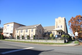
- This building was originally built in 1926 as the Vancouver Heights United Church; a Sunday School was added in 1931, which conformed to the church building’s Romanesque influenced style. This unique Burnaby building has retained its remarkable three-storey tower with buttresses and stepped parapet. It now houses the New Apostolic Church.
- Locality
- Vancouver Heights
- Historic Neighbourhood
- Vancouver Heights (Historic Neighbourhood)
- Planning Study Area
- Burnaby Heights Area
- Area
- 1133.42
- Contributing Resource
- Building
- Ownership
- Private
- Street Address
- 271 Ingleton Avenue
- Street View URL
- Google Maps Street View
Images
Cabinets of curiosities : collections of the Vancouver Museum, 1894-1981
https://search.heritageburnaby.ca/link/museumlibrary981
- Repository
- Burnaby Village Museum
- Author
- Vancouver Museum
- Publication Date
- c1982
- Call Number
- 708.11 CAB
- Repository
- Burnaby Village Museum
- Collection
- Reference Collection
- Material Type
- Book
- ISBN
- 0919253067
- Call Number
- 708.11 CAB
- Author
- Vancouver Museum
- Contributor
- Maranda, Lynn, 1942-
- Mayer, Carol E. (Carol Elizabeth), 1945-
- Sayers, Ivan W. (Ivan William), 1946-
- Vancouver Museums and Planetarium Association
- Place of Publication
- Vancouver
- Publisher
- Vancouver Museums and Planetarium Association
- Publication Date
- c1982
- Physical Description
- iv, 92, v-xi p. : ill. (some col.) ; 23 cm.
- Library Subject (LOC)
- Vancouver Museum
- Catalogs
- Notes
- "Prepared by ... Lynn Maranda, Carol Mayer and Ivan Sayers"--p. iv.
- Includes index.
City of Vancouver heritage inventory of Vancouver schools : report
https://search.heritageburnaby.ca/link/museumlibrary1000
- Repository
- Burnaby Village Museum
- Author
- Bodnar, Diana, 1950-
- Publication Date
- 1982
- Call Number
- 727. BOD
- Repository
- Burnaby Village Museum
- Collection
- Reference Collection
- Material Type
- Book
- Call Number
- 727. BOD
- Author
- Bodnar, Diana, 1950-
- Place of Publication
- [Vancouver, B.C]
- Publisher
- City of Vancouver
- Publication Date
- 1982
- Physical Description
- 60 leaves : ill. ; 28 cm.
- Library Subject (LOC)
- Architecture
- Subjects
- Buildings - Heritage
- Buildings - Schools
- Geographic Access
- Vancouver
- Notes
- Includes bibliographical references (p. 58-60).
- Prepared for the Vancouver Heritage Advisory Committee.
Conference with Vancouver City Authorities re Proposed Greater Vancouver Water Commission
https://search.heritageburnaby.ca/link/councilreport68593
- Repository
- City of Burnaby Archives
- Report ID
- 73165
- Meeting Date
- 11-Nov-1924
- Format
- Council - Mayor/Councillor/Staff Report
- Collection/Fonds
- City Council and Office of the City Clerk fonds
- Repository
- City of Burnaby Archives
- Report ID
- 73165
- Meeting Date
- 11-Nov-1924
- Format
- Council - Mayor/Councillor/Staff Report
- Collection/Fonds
- City Council and Office of the City Clerk fonds
Documents
Fires re Lists of Attendances Made by the Fire Departments of New Westminster, Vancouver and South Vancouver
https://search.heritageburnaby.ca/link/councilreport68931
- Repository
- City of Burnaby Archives
- Report ID
- 59870
- Meeting Date
- 31-Jul-1922
- Format
- Council - Mayor/Councillor/Staff Report
- Collection/Fonds
- City Council and Office of the City Clerk fonds
- Repository
- City of Burnaby Archives
- Report ID
- 59870
- Meeting Date
- 31-Jul-1922
- Format
- Council - Mayor/Councillor/Staff Report
- Collection/Fonds
- City Council and Office of the City Clerk fonds
Documents
Greater Vancouver Regional District Brief to the Industrial Inquiry Commission on Port of Vancouver Container Traffic
https://search.heritageburnaby.ca/link/councilreport15006
- Repository
- City of Burnaby Archives
- Report ID
- 11124
- Meeting Date
- 2-Mar-1987
- Format
- Council - Manager's Report
- Manager's Report No.
- 15
- Item No.
- 19
- Collection/Fonds
- City Council and Office of the City Clerk fonds
- Repository
- City of Burnaby Archives
- Report ID
- 11124
- Meeting Date
- 2-Mar-1987
- Format
- Council - Manager's Report
- Manager's Report No.
- 15
- Item No.
- 19
- Collection/Fonds
- City Council and Office of the City Clerk fonds
Documents
Letter from Mayor Donald A.S. Lanskail, Chairman, Vancouver Regional Transit Commission, c/o Municipal Hall, 750 - 17th Street, West Vancouver, BC, V7V 3T3 Structure and Organization of Transit
https://search.heritageburnaby.ca/link/councilreport13822
- Repository
- City of Burnaby Archives
- Report ID
- 9190
- Meeting Date
- 13-Jun-1988
- Format
- Council - Manager's Report
- Manager's Report No.
- 41
- Item No.
- 15
- Collection/Fonds
- City Council and Office of the City Clerk fonds
- Repository
- City of Burnaby Archives
- Report ID
- 9190
- Meeting Date
- 13-Jun-1988
- Format
- Council - Manager's Report
- Manager's Report No.
- 41
- Item No.
- 15
- Collection/Fonds
- City Council and Office of the City Clerk fonds
Documents
Letter from the City of North Vancouver re:City of North Vancouver Resolution, Section 26 (2) BC Fire Services Act
https://search.heritageburnaby.ca/link/councilreport15390
- Repository
- City of Burnaby Archives
- Report ID
- 10681
- Meeting Date
- 5-Aug-1986
- Format
- Council - Manager's Report
- Manager's Report No.
- 46
- Item No.
- 20
- Collection/Fonds
- City Council and Office of the City Clerk fonds
- Repository
- City of Burnaby Archives
- Report ID
- 10681
- Meeting Date
- 5-Aug-1986
- Format
- Council - Manager's Report
- Manager's Report No.
- 46
- Item No.
- 20
- Collection/Fonds
- City Council and Office of the City Clerk fonds
Documents
Letter from the Corporation of the District of North Vancouver which appeared on the agenda for the May 15 meeting of Council (Item 1) re: Amendment to North Vancouver District Official Community Plan
https://search.heritageburnaby.ca/link/councilreport12908
- Repository
- City of Burnaby Archives
- Report ID
- 8139
- Meeting Date
- 23-May-1989
- Format
- Council - Manager's Report
- Manager's Report No.
- 38
- Item No.
- 17
- Collection/Fonds
- City Council and Office of the City Clerk fonds
- Repository
- City of Burnaby Archives
- Report ID
- 8139
- Meeting Date
- 23-May-1989
- Format
- Council - Manager's Report
- Manager's Report No.
- 38
- Item No.
- 17
- Collection/Fonds
- City Council and Office of the City Clerk fonds
Documents
Reference to the Joint Conference at the Vancouver City Hall re Proposed Water Commission for Greater Vancouver
https://search.heritageburnaby.ca/link/councilreport68968
- Repository
- City of Burnaby Archives
- Report ID
- 60007
- Meeting Date
- 14-Aug-1922
- Format
- Council - Mayor/Councillor/Staff Report
- Collection/Fonds
- City Council and Office of the City Clerk fonds
- Repository
- City of Burnaby Archives
- Report ID
- 60007
- Meeting Date
- 14-Aug-1922
- Format
- Council - Mayor/Councillor/Staff Report
- Collection/Fonds
- City Council and Office of the City Clerk fonds
Documents
Summary of Meeting with South Vancouver Point Grey re Value of Assets Proposed to be Taken Over by the Greater Vancouver Water District Act
https://search.heritageburnaby.ca/link/councilreport70087
- Repository
- City of Burnaby Archives
- Report ID
- 75055
- Meeting Date
- 28-Sep-1925
- Format
- Council - Mayor/Councillor/Staff Report
- Collection/Fonds
- City Council and Office of the City Clerk fonds
- Repository
- City of Burnaby Archives
- Report ID
- 75055
- Meeting Date
- 28-Sep-1925
- Format
- Council - Mayor/Councillor/Staff Report
- Collection/Fonds
- City Council and Office of the City Clerk fonds
Documents
Westminister and Vancouver Electric Railway Co. re Extension of Edmonds Street to Vancouver Roads
https://search.heritageburnaby.ca/link/councilreport77405
- Repository
- City of Burnaby Archives
- Report ID
- 82667
- Meeting Date
- 12-Jan-1903
- Format
- Council - Mayor/Councillor/Staff Report
- Collection/Fonds
- City Council and Office of the City Clerk fonds
- Repository
- City of Burnaby Archives
- Report ID
- 82667
- Meeting Date
- 12-Jan-1903
- Format
- Council - Mayor/Councillor/Staff Report
- Collection/Fonds
- City Council and Office of the City Clerk fonds
Documents
Angus & Margaret MacDonald House
https://search.heritageburnaby.ca/link/landmark495
- Repository
- Burnaby Heritage Planning
- Description
- Set on a large corner lot at North Esmond Avenue and Oxford Street, the Angus & Margaret MacDonald House is a prominent, two and one-half storey Queen Anne Revival-style residence. The high hipped roof has open projecting gables. The house is a landmark within the Vancouver Heights neighbourhood of…
- Associated Dates
- 1909
- Formal Recognition
- Heritage Designation, Community Heritage Register
- Street View URL
- Google Maps Street View
- Repository
- Burnaby Heritage Planning
- Geographic Access
- Oxford Street
- Associated Dates
- 1909
- Formal Recognition
- Heritage Designation, Community Heritage Register
- Enactment Type
- Bylaw No. 12174
- Enactment Date
- 11/12/2006
- Description
- Set on a large corner lot at North Esmond Avenue and Oxford Street, the Angus & Margaret MacDonald House is a prominent, two and one-half storey Queen Anne Revival-style residence. The high hipped roof has open projecting gables. The house is a landmark within the Vancouver Heights neighbourhood of North Burnaby, on a high point of land overlooking Burrard Inlet and the North Shore Mountains.
- Heritage Value
- The MacDonald House is valued as one of Burnaby’s most elaborate examples of the Queen Anne Revival style. The house retains many of its original features, including a prominent front corner turret wrapped by a clamshell verandah. The eclectic and transitional nature of Edwardian-era architecture is demonstrated by the late persistence of these Queen Anne Revival details, combined with the use of newly-popular classical revival elements such as Ionic columns. The interior retains a number of original architectural elements, and the early garage at the rear originally housed Angus MacDonald’s Cadillac, one of the first known automobiles owned by a Burnaby resident. Constructed in 1909, this house was built for Angus MacDonald (1857-1943) and his wife, Margaret Isabella Thompson MacDonald (1862-1939). Angus MacDonald, an electrical contractor, relocated from Nova Scotia to Vancouver in 1891 and served on Vancouver Council from 1904-08. The MacDonald family moved to Burnaby upon his retirement from the B.C. Electric Railway Company, and he then served the North Burnaby Ward as a councillor from 1911-1916 and again in 1921. MacDonald Street in Burnaby was named in his honour. The MacDonald House has additional significance as one of the surviving landmark residences, built between 1909 and 1914, during the first development of Vancouver Heights. In 1909, C.J. Peter and his employer, G.F. and J. Galt Limited, initiated the development of this North Burnaby neighbourhood, promoting it as one of the most picturesque districts in the region and an alternative to the CPR’s prestigious Shaughnessy Heights development in Vancouver. Buyers were obligated to build houses worth $3,500 at a time when the average house price was $1,000. Reputed to be the second house built in the subdivision, this house cost $7,000 to build.
- Defining Elements
- Key elements that define the heritage character of the MacDonald House include its: - prominent corner location in the Vancouver Heights neighbourhood, with views to Burrard Inlet and the North Shore Mountains - residential form, scale and massing as exemplified by its two and one-half storey height, full basement, compound plan, and high hipped roof with gabled projections at the front and side - wood-frame construction including wooden lapped siding, trim and mouldings - rubble-stone granite foundation - Queen Anne Revival details such as scroll-cut modillions, octagonal corner turret, wraparound, clamshell verandah with classical columns, and projecting square and semi-octagonal bays - external red-brick chimney with corbelled top - original windows including double-hung, 1-over-1 wooden sash windows in single and double assembly, and arched-top casement windows in the gable peaks - original interior features such as the main staircase, a panelled dining room with a fireplace and built-in cabinets, a living room with a parquet floor, and a rear den with an oak mantle and tiled hearth - associated early wood-frame garage at the rear of the property - landscape features such as mature coniferous and deciduous trees surrounding the property
- Historic Neighbourhood
- Vancouver Heights (Historic Neighbourhood)
- Planning Study Area
- Burnaby Heights Area
- Organization
- British Columbia Mills Timber and Trading Company
- Function
- Primary Historic--Single Dwelling
- Primary Current--Single Dwelling
- Community
- Vancouver Heights
- Cadastral Identifier
- P.I.D.011-999-462
- Boundaries
- The MacDonald House is comprised of a single residential lot located at 3814 Oxford Street, Burnaby.
- Area
- 566.71
- Contributing Resource
- Building
- Ownership
- Private
- Documentation
- City of Burnaby Planning and Building Department, Heritage Site Files
- Street Address
- 3814 Oxford Street
- Street View URL
- Google Maps Street View
Images
Burnaby Heights Neighbourhood
https://search.heritageburnaby.ca/link/landmark776
- Repository
- Burnaby Heritage Planning
- Associated Dates
- 1955-2008
- Heritage Value
- Up until the 1970s, this neighbourhood was known as Vancouver Heights. When a new park was created during that decade and named "Burnaby Heights Park," the name was gradually adopted by newcomers to the area. Today, you will hear residents refer to their neighbourhood as Burnaby Heights, Vancouver Heights, or just "The Heights." Throughout the 1960s and 1970s, the commercial district in this neighbourhood continued to grow and a Retail Merchants Association was formed which later became known as the Heights Merchants Association. The neighbourhood still retains a residential neighbourhood characteristic with an increasing number of apartment buildings and multi-family units being built over the past 20 years.
- Historic Neighbourhood
- Vancouver Heights (Historic Neighbourhood)
- Planning Study Area
- Burnaby Heights Area
Images
Crabtown
https://search.heritageburnaby.ca/link/landmark674
- Repository
- Burnaby Heritage Planning
- Associated Dates
- 1912-1957
- Heritage Value
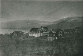
- North Burnaby's waterfront was the location of a unique squatter's community known as Crabtown. Although its origins are obscure, it is believed that the first shacks were built before 1912. When the depression of 1913-1917 began, the shacks became permanent homes for impoverished workers. During the Great Depression of the 1930s, the community grew larger. Crabtown was not a slum, but a neighbourhood - the community even rallied together to build a water supply system and trails up the steep bluff with steps and banisters so children could go to school safely. In 1957, the National Harbours Board decided that Crabtown was encroaching on Federal property and evicted all 130 residents. Within a few months, residents were relocated and 114 homes were levelled.
- Historic Neighbourhood
- Vancouver Heights (Historic Neighbourhood)
- Planning Study Area
- Burnaby Heights Area
Images
François & Cezarie Comeau Residence
https://search.heritageburnaby.ca/link/landmark580
- Repository
- Burnaby Heritage Planning
- Description
- Residential building.
- Associated Dates
- c.1925
- Street View URL
- Google Maps Street View
- Repository
- Burnaby Heritage Planning
- Geographic Access
- Esmond Avenue
- Associated Dates
- c.1925
- Description
- Residential building.
- Heritage Value
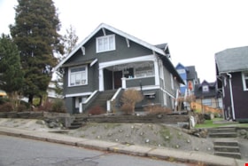
- This home was built for Francois Xavier “Frank” Comeau (1863-1943), a blacksmith who moved from Quebec to Vancouver in about 1890, and his wife Cezarie Marie (née Fortin, 1860-1950), also from Quebec, whom he married in 1903. Featuring a front gabled roof with decorative triangular eave brackets, this comfortable Craftsman bungalow displays other characteristics typical of the style such as lapped siding at the foundation, a shingle-clad main floor, casement windows and stained glass transoms on the front elevation. The most notable feature of the plan is the inset verandah with subtle segmental-arched openings and tapered square columns.
- Locality
- Vancouver Heights
- Historic Neighbourhood
- Vancouver Heights (Historic Neighbourhood)
- Planning Study Area
- Burnaby Heights Area
- Area
- 566.71
- Contributing Resource
- Building
- Ownership
- Private
- Street Address
- 306 Esmond Avenue
- Street View URL
- Google Maps Street View
Images
George & Rose Nuttall Residence
https://search.heritageburnaby.ca/link/landmark585
- Repository
- Burnaby Heritage Planning
- Description
- Residential building.
- Associated Dates
- 1921
- Other Names
- HILLCREST
- Street View URL
- Google Maps Street View
- Repository
- Burnaby Heritage Planning
- Other Names
- HILLCREST
- Geographic Access
- McGill Street
- Associated Dates
- 1921
- Description
- Residential building.
- Heritage Value
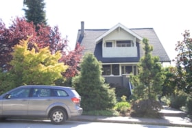
- This house was built for local plumber contractor George Nuttall (1883-1970) and his wife Rose Ann Nuttall (née Clagg, 1881-1955). George continued to live in the house after Rose’s death, until his own death in 1970. Although typical of the Craftsman style and form with its side-gabled roof, triangular eave brackets and front gabled dormer, this house has a number of special details, such as its beautiful art glass transom windows. The front verandah supports are massive stucco columns that contain stained glass lanterns with the house name, Hillcrest, and address.
- Locality
- Vancouver Heights
- Historic Neighbourhood
- Vancouver Heights (Historic Neighbourhood)
- Planning Study Area
- Burnaby Heights Area
- Area
- 566.71
- Contributing Resource
- Building
- Ownership
- Private
- Street Address
- 3756 McGill Street
- Street View URL
- Google Maps Street View
Images
Hastings Barnet Road
https://search.heritageburnaby.ca/link/landmark715
- Repository
- Burnaby Heritage Planning
- Associated Dates
- 1903
- Heritage Value
- Prior to 1900, Hastings Street in Vancouver (named after Rear Admiral George Fowler Hastings, commander of Her Majesty's Pacific Coast Squadron) only extended eastward as far as Renfrew Street. By 1903, however, with operations at the Barnet Mill expanding, a direct route into Vancouver was deemed necessary and the Provincial Government ordered that Hastings be extended to connect with the rough trail known as the Barnet Road.
- Historic Neighbourhood
- Vancouver Heights (Historic Neighbourhood)
- Planning Study Area
- Burnaby Heights Area

