Narrow Results By
Subject
- Accidents 6
- Accidents - Automobile Accidents 6
- Accidents - Train Accidents 9
- Adornment - Jewelry 1
- Advertising Medium - Signs and Signboards 31
- Aerial Photographs
- Agricultural Tools and Equipment 4
- Agricultural Tools and Equipment - Gardening Equipment 4
- Agricultural Tools and Equipment - Plows 2
- Agriculture 8
- Agriculture - Crops 10
- Agriculture - Farms
![Aerial photograph of Douglas Road and Sperling Avenue, [1938] thumbnail](/media/hpo/_Data/_BVM_Images/1990/199200470001.jpg?width=280)
Aerial photograph of Douglas Road and Sperling Avenue
https://search.heritageburnaby.ca/link/museumdescription1165
- Repository
- Burnaby Village Museum
- Date
- [1938]
- Collection/Fonds
- Burnaby Village Museum Photograph collection
- Description Level
- Item
- Physical Description
- 1 photograph : b&w ; 19 x 24 cm
- Scope and Content
- Aerial photograph of the area surrounding Douglas Road and Sperling Avenue.
- Repository
- Burnaby Village Museum
- Collection/Fonds
- Burnaby Village Museum Photograph collection
- Description Level
- Item
- Physical Description
- 1 photograph : b&w ; 19 x 24 cm
- Scope and Content
- Aerial photograph of the area surrounding Douglas Road and Sperling Avenue.
- Subjects
- Aerial Photographs
- Geographic Access
- Douglas Road
- Sperling Avenue
- Accession Code
- BV992.47.1
- Access Restriction
- No restrictions
- Date
- [1938]
- Media Type
- Photograph
- Historic Neighbourhood
- Burnaby Lake (Historic Neighbourhood)
- Planning Study Area
- Morley-Buckingham Area
- Scan Resolution
- 600
- Scan Date
- 01-Jun-09
- Scale
- 100
- Notes
- Title based on contents of photograph
- Notes on verso of photograph read: "Burnaby Image Bank #532" and "DOUGLAS ROAD AND SPERLING c. 1938"
- Stamp on verso of photograph reads: "Copyright Simon Fraser/ University Archives"
Images
![Aerial photograph of Douglas Road and Sperling Avenue, [1938] thumbnail](/media/hpo/_Data/_BVM_Images/1990/199200470001.jpg)

Aeroplane view of the Barnet Lumber Co.
https://search.heritageburnaby.ca/link/archivedescription38679
- Repository
- City of Burnaby Archives
- Date
- 1927
- Collection/Fonds
- Burnaby Historical Society fonds
- Description Level
- Item
- Physical Description
- 1 photograph : sepia postcard ; 8.9 x 13.4 cm
- Scope and Content
- Aerial photographic postcard of Barnet Lumber Company's Mill. The handwritten caption on the lower left corner of the postcard reads: "Aeroplane view of the Barnet Lumber Co. Ltd./ Barnet BC." The handwritten caption on the lower right corner reads: "Copyright 1927/ Pacific Airway Ltd./ Vancouver …
- Repository
- City of Burnaby Archives
- Date
- 1927
- Collection/Fonds
- Burnaby Historical Society fonds
- Subseries
- North Burnaby Board of Trade subseries
- Physical Description
- 1 photograph : sepia postcard ; 8.9 x 13.4 cm
- Description Level
- Item
- Record No.
- 476-022
- Access Restriction
- No restrictions
- Reproduction Restriction
- No known restrictions
- Accession Number
- BHS2005-8
- Scope and Content
- Aerial photographic postcard of Barnet Lumber Company's Mill. The handwritten caption on the lower left corner of the postcard reads: "Aeroplane view of the Barnet Lumber Co. Ltd./ Barnet BC." The handwritten caption on the lower right corner reads: "Copyright 1927/ Pacific Airway Ltd./ Vancouver B.C.".
- Subjects
- Aerial Photographs
- Industries - Forestry
- Buildings - Industrial - Mills
- Documentary Artifacts - Postcards
- Industries - Logging/lumber
- Names
- Barnet Mill
- Media Type
- Photograph
- Photographer
- Pacific Airway Ltd.
- Responsibility
- Published by the Gowen, Sutton Co. Ltd., Vancouver
- Notes
- Transcribed title
- Geographic Access
- Barnet Village
- Texaco Drive
- Street Address
- 8059 Texaco Drive
- Historic Neighbourhood
- Barnet (Historic Neighbourhood)
- Planning Study Area
- Burnaby Mountain Area
Images


Boberg family home and farm
https://search.heritageburnaby.ca/link/archivedescription35772
- Repository
- City of Burnaby Archives
- Date
- 1924
- Collection/Fonds
- Burnaby Historical Society fonds
- Description Level
- Item
- Physical Description
- 1 photograph : b&w ; 12.7 x 17.8 cm print
- Scope and Content
- Photograph of the Boberg family home and farm on Douglas Road. Shown on the back porch, John Boberg (father) and Elin Boberg (mother) holding their only son, John, then 3 years old (born 1921).
- Repository
- City of Burnaby Archives
- Date
- 1924
- Collection/Fonds
- Burnaby Historical Society fonds
- Subseries
- Pioneer Tales subseries
- Physical Description
- 1 photograph : b&w ; 12.7 x 17.8 cm print
- Description Level
- Item
- Record No.
- 204-630
- Access Restriction
- No restrictions
- Reproduction Restriction
- No known restrictions
- Accession Number
- BHS1988-03
- Scope and Content
- Photograph of the Boberg family home and farm on Douglas Road. Shown on the back porch, John Boberg (father) and Elin Boberg (mother) holding their only son, John, then 3 years old (born 1921).
- Media Type
- Photograph
- Notes
- Title based on contents of photograph
- Historic Neighbourhood
- Burnaby Lake (Historic Neighbourhood)
- Planning Study Area
- Ardingley-Sprott Area
Images


Broadway Jersey Ranch
https://search.heritageburnaby.ca/link/archivedescription38259
- Repository
- City of Burnaby Archives
- Date
- 1931
- Collection/Fonds
- Burnaby Historical Society fonds
- Description Level
- Item
- Physical Description
- 1 photograph : b&w ; 10.5 x 15.4 cm
- Scope and Content
- Photograph of a house and barn identified as E.W. Nicholson's "Broadway Jersey Ranch." Three men and a team of horses can be seen to the right of the house. The men may be E.W. Nicholoson, John McCallum and George Dell.
- Repository
- City of Burnaby Archives
- Date
- 1931
- Collection/Fonds
- Burnaby Historical Society fonds
- Subseries
- Margaret McCallum subseries
- Physical Description
- 1 photograph : b&w ; 10.5 x 15.4 cm
- Description Level
- Item
- Record No.
- 375-021
- Access Restriction
- No restrictions
- Reproduction Restriction
- No known restrictions
- Accession Number
- BHS1986-42
- Scope and Content
- Photograph of a house and barn identified as E.W. Nicholson's "Broadway Jersey Ranch." Three men and a team of horses can be seen to the right of the house. The men may be E.W. Nicholoson, John McCallum and George Dell.
- Media Type
- Photograph
- Notes
- Title based on caption
- Geographic Access
- Boundary Road
- Street Address
- 2550 Boundary Road
- Historic Neighbourhood
- Broadview (Historic Neighbourhood)
- Planning Study Area
- West Central Valley Area
Images


Brown Family and Home
https://search.heritageburnaby.ca/link/archivedescription35673
- Repository
- City of Burnaby Archives
- Date
- 1920 (date of original), copied 1986
- Collection/Fonds
- Burnaby Historical Society fonds
- Description Level
- Item
- Physical Description
- 1 photograph : b&w ; 12.7 x 17.8 cm print
- Scope and Content
- Photograph of the Brown family feeding chickens. From left: Alex Brown (brother, later to become MD), Janet Brown (sister), and Janet Mackintosh Macfarlane Maclean (grandmother). This photograph was taken in back of the Brown family home, 3846 Triumph, Vancouver Heights. The house was owned by t…
- Repository
- City of Burnaby Archives
- Date
- 1920 (date of original), copied 1986
- Collection/Fonds
- Burnaby Historical Society fonds
- Subseries
- Pioneer Tales subseries
- Physical Description
- 1 photograph : b&w ; 12.7 x 17.8 cm print
- Description Level
- Item
- Record No.
- 204-531
- Access Restriction
- No restrictions
- Reproduction Restriction
- No known restrictions
- Accession Number
- BHS1988-03
- Scope and Content
- Photograph of the Brown family feeding chickens. From left: Alex Brown (brother, later to become MD), Janet Brown (sister), and Janet Mackintosh Macfarlane Maclean (grandmother). This photograph was taken in back of the Brown family home, 3846 Triumph, Vancouver Heights. The house was owned by the grandmother.
- Subjects
- Animals - Poultry
- Agriculture - Farms
- Media Type
- Photograph
- Notes
- Title based on contents of photograph
- Geographic Access
- Triumph Street
- Street Address
- 3846 Triumph Street
- Historic Neighbourhood
- Vancouver Heights (Historic Neighbourhood)
- Planning Study Area
- Burnaby Heights Area
Images

![Burnaby Lake, [193-] thumbnail](/media/hpo/_Data/_Archives_Images/_Unrestricted/001/072-001.jpg?width=280)
Burnaby Lake
https://search.heritageburnaby.ca/link/archivedescription34637
- Repository
- City of Burnaby Archives
- Date
- [193-]
- Collection/Fonds
- Burnaby Historical Society fonds
- Description Level
- Item
- Physical Description
- 1 photograph : b&w ; 12.7 x 20.3 cm
- Scope and Content
- Aerial photograph of Burnaby Lake and North Burnaby.
- Repository
- City of Burnaby Archives
- Date
- [193-]
- Collection/Fonds
- Burnaby Historical Society fonds
- Subseries
- Photographs subseries
- Physical Description
- 1 photograph : b&w ; 12.7 x 20.3 cm
- Description Level
- Item
- Record No.
- 072-001
- Access Restriction
- No restrictions
- Reproduction Restriction
- No known restrictions
- Accession Number
- BHS2007-04
- Scope and Content
- Aerial photograph of Burnaby Lake and North Burnaby.
- Media Type
- Photograph
- Notes
- Title based on contents of photograph
- Geographic Access
- Burnaby Lake
- Historic Neighbourhood
- Burnaby Lake (Historic Neighbourhood)
- Lozells (Historic Neighbourhood)
- Lochdale (Historic Neighbourhood)
- Planning Study Area
- Parkcrest-Aubrey Area
- Ardingley-Sprott Area
- Burnaby Lake Area
- Government Road Area
- Sperling-Broadway Area
- Lochdale Area
Images
![Burnaby Lake, [193-] thumbnail](/media/hpo/_Data/_Archives_Images/_Unrestricted/001/072-001.jpg)
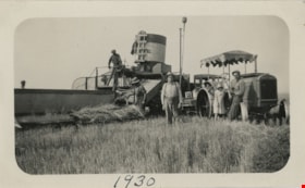
Combining in field
https://search.heritageburnaby.ca/link/museumdescription19919
- Repository
- Burnaby Village Museum
- Date
- 1930
- Collection/Fonds
- Esther Love Stanley fonds
- Description Level
- Item
- Physical Description
- 1 photograph : b&w ; 7 x 11.5 cm
- Scope and Content
- Photograph of four men and child with combining equipment in a field in Alberta. Two men are working with a combine to harvest grain and the others are standing nearby. Man standing in centre is identified as Orrie Sommers' dad, one man on combine is identified as Orrie's brother, child and man sta…
- Repository
- Burnaby Village Museum
- Collection/Fonds
- Esther Love Stanley fonds
- Description Level
- Item
- Physical Description
- 1 photograph : b&w ; 7 x 11.5 cm
- Scope and Content
- Photograph of four men and child with combining equipment in a field in Alberta. Two men are working with a combine to harvest grain and the others are standing nearby. Man standing in centre is identified as Orrie Sommers' dad, one man on combine is identified as Orrie's brother, child and man standing next to tractor are identified as "Irene" and "Fred".
- Subjects
- Agriculture
- Agriculture - Farms
- Accession Code
- BV022.32.341
- Access Restriction
- No restrictions
- Reproduction Restriction
- No known restrictions
- Date
- 1930
- Media Type
- Photograph
- Scan Resolution
- 600
- Scan Date
- 2023-06-09
- Notes
- Title based on contents of photograph
- Photograph is part of Esther Love Stanley photograph album 1 (BV022.32.1)
- Note in black ink on verso of photograph reads: "This is in 1930 / combining on Orrie / brothers place which / we rent. / Orries Dad in centre / Irene & Fred. / His brother [Orlif] & / man on combine. / The other man / is a salesman. / They are always / thick in the fall"
- Note in ink on lower recto of photograph reads: "1930"
Images


Construction of dykes on Nicomen Island
https://search.heritageburnaby.ca/link/archivedescription34330
- Repository
- City of Burnaby Archives
- Date
- 1927
- Collection/Fonds
- Burnaby Historical Society fonds
- Description Level
- Item
- Physical Description
- 1 photograph : sepia ; 5 x 13.5 cm on page 17.5 x 22.7 cm
- Scope and Content
- Photograph of a farm and field along the Fraser River next to dykes that are being built on Nicomen Island.
- Repository
- City of Burnaby Archives
- Date
- 1927
- Collection/Fonds
- Burnaby Historical Society fonds
- Subseries
- Peers family subseries
- Physical Description
- 1 photograph : sepia ; 5 x 13.5 cm on page 17.5 x 22.7 cm
- Description Level
- Item
- Record No.
- 020-037
- Access Restriction
- No restrictions
- Reproduction Restriction
- No known restrictions
- Accession Number
- BHS2007-04
- Scope and Content
- Photograph of a farm and field along the Fraser River next to dykes that are being built on Nicomen Island.
- Media Type
- Photograph
- Notes
- Title based on caption accompanying photograph
Images


Cows in the field at the Nicholson Farm
https://search.heritageburnaby.ca/link/archivedescription38257
- Repository
- City of Burnaby Archives
- Date
- 1933
- Collection/Fonds
- Burnaby Historical Society fonds
- Description Level
- Item
- Physical Description
- 1 photograph : b&w ; 8 x 12.5 cm
- Scope and Content
- Photograph of Jersey cows in the field on E.W. Nicholson's Farm. The Dominion Bridge Building can be seen faintly in the backgound (at 3880 Henning Drive).
- Repository
- City of Burnaby Archives
- Date
- 1933
- Collection/Fonds
- Burnaby Historical Society fonds
- Subseries
- Margaret McCallum subseries
- Physical Description
- 1 photograph : b&w ; 8 x 12.5 cm
- Description Level
- Item
- Record No.
- 375-019
- Access Restriction
- No restrictions
- Reproduction Restriction
- No known restrictions
- Accession Number
- BHS1986-42
- Scope and Content
- Photograph of Jersey cows in the field on E.W. Nicholson's Farm. The Dominion Bridge Building can be seen faintly in the backgound (at 3880 Henning Drive).
- Subjects
- Agriculture - Farms
- Animals - Cows
- Names
- Dominion Bridge Company
- Media Type
- Photograph
- Notes
- Title based on contents of photograph.
- Geographic Access
- Boundary Road
- Henning Drive
- Street Address
- 2550 Boundary Road
- 3880 Henning Drive
- Historic Neighbourhood
- Broadview (Historic Neighbourhood)
- Planning Study Area
- West Central Valley Area
Images


Cram family fruit stand
https://search.heritageburnaby.ca/link/archivedescription35703
- Repository
- City of Burnaby Archives
- Date
- 1920 (date of original), copied 1986
- Collection/Fonds
- Burnaby Historical Society fonds
- Description Level
- Item
- Physical Description
- 1 photograph : b&w ; 12.7 x 17.8 cm print
- Scope and Content
- Photograph of the Cram roadside fruit stand on Kingsway with Mary Cram in front. The Cram family sold fruit, produce, honey, and cottage cheese from their farm at Kingsway and what is now 6515 Denbigh Avenue. The stand was located directly in front of the Cram-Tidball family home.
- Repository
- City of Burnaby Archives
- Date
- 1920 (date of original), copied 1986
- Collection/Fonds
- Burnaby Historical Society fonds
- Subseries
- Pioneer Tales subseries
- Physical Description
- 1 photograph : b&w ; 12.7 x 17.8 cm print
- Description Level
- Item
- Record No.
- 204-561
- Access Restriction
- No restrictions
- Reproduction Restriction
- No known restrictions
- Accession Number
- BHS1988-03
- Scope and Content
- Photograph of the Cram roadside fruit stand on Kingsway with Mary Cram in front. The Cram family sold fruit, produce, honey, and cottage cheese from their farm at Kingsway and what is now 6515 Denbigh Avenue. The stand was located directly in front of the Cram-Tidball family home.
- Names
- Vogt, Mary Cram
- Media Type
- Photograph
- Notes
- Title based on contents of photograph
- Geographic Access
- Denbigh Avenue
- Street Address
- 6515 Denbigh Avenue
- Historic Neighbourhood
- Central Park (Historic Neighbourhood)
- Planning Study Area
- Windsor Area
Images

![Elgin Avenue farmhouse, [between 1920 and 1925] (date of original), copied 1986 thumbnail](/media/hpo/_Data/_Archives_Images/_Unrestricted/126/179-005.jpg?width=280)
Elgin Avenue farmhouse
https://search.heritageburnaby.ca/link/archivedescription35034
- Repository
- City of Burnaby Archives
- Date
- [between 1920 and 1925] (date of original), copied 1986
- Collection/Fonds
- Burnaby Historical Society fonds
- Description Level
- Item
- Physical Description
- 1 photograph : b&w ; 8.7 x 12.7 cm print
- Scope and Content
- Photograph of the exterior of an Elgin Avenue farmhouse and surrounding property. The farmhouse is at the left side of the photograph, and a chicken barn is at the right side. This may be 6389 Elgin Avenue.
- Repository
- City of Burnaby Archives
- Date
- [between 1920 and 1925] (date of original), copied 1986
- Collection/Fonds
- Burnaby Historical Society fonds
- Subseries
- Chamberlain family subseries
- Physical Description
- 1 photograph : b&w ; 8.7 x 12.7 cm print
- Description Level
- Item
- Record No.
- 179-005
- Access Restriction
- No restrictions
- Reproduction Restriction
- No known restrictions
- Accession Number
- BHS1986-27
- Scope and Content
- Photograph of the exterior of an Elgin Avenue farmhouse and surrounding property. The farmhouse is at the left side of the photograph, and a chicken barn is at the right side. This may be 6389 Elgin Avenue.
- Media Type
- Photograph
- Notes
- Title based on contents of photograph
- Geographic Access
- Elgin Avenue
- Street Address
- 6389 Elgin Avenue
- Historic Neighbourhood
- Central Park (Historic Neighbourhood)
- Planning Study Area
- Windsor Area
Images
![Elgin Avenue farmhouse, [between 1920 and 1925] (date of original), copied 1986 thumbnail](/media/hpo/_Data/_Archives_Images/_Unrestricted/126/179-005.jpg)
![Elsie Nicholson, [1921] thumbnail](/media/hpo/_Data/_Archives_Images/_Unrestricted/371/375-002.jpg?width=280)
Elsie Nicholson
https://search.heritageburnaby.ca/link/archivedescription38241
- Repository
- City of Burnaby Archives
- Date
- [1921]
- Collection/Fonds
- Burnaby Historical Society fonds
- Description Level
- Item
- Physical Description
- 1 photograph : b&w ; 8 x 12.2 cm
- Scope and Content
- Photograph of Elsie Nicholson standing next to the horse named "Holly" at the Nicholson farm in the area of Boundary Road and the C.N.R. rail line. The barns and farm outbuildings can be seen in the background.
- Repository
- City of Burnaby Archives
- Date
- [1921]
- Collection/Fonds
- Burnaby Historical Society fonds
- Subseries
- Margaret McCallum subseries
- Physical Description
- 1 photograph : b&w ; 8 x 12.2 cm
- Description Level
- Item
- Record No.
- 375-002
- Access Restriction
- No restrictions
- Reproduction Restriction
- No known restrictions
- Accession Number
- BHS1986-42
- Scope and Content
- Photograph of Elsie Nicholson standing next to the horse named "Holly" at the Nicholson farm in the area of Boundary Road and the C.N.R. rail line. The barns and farm outbuildings can be seen in the background.
- Subjects
- Agriculture - Farms
- Occupations - Farmers
- Agriculture - Crops
- Transportation - Horses
- Animals - Dogs
- Transportation - Wagons
- Names
- Nicholson, Elsie
- Media Type
- Photograph
- Notes
- Title based on contents of photograph
- Geographic Access
- Boundary Road
- Street Address
- 2550 Boundary Road
- Historic Neighbourhood
- Broadview (Historic Neighbourhood)
- Planning Study Area
- West Central Valley Area
Images
![Elsie Nicholson, [1921] thumbnail](/media/hpo/_Data/_Archives_Images/_Unrestricted/371/375-002.jpg)
![Ernest and Frank Street, [between 1920 and 1925] thumbnail](/media/hpo/_Data/_Archives_Images/_Unrestricted/205/217-004.jpg?width=280)
Ernest and Frank Street
https://search.heritageburnaby.ca/link/archivedescription36072
- Repository
- City of Burnaby Archives
- Date
- [between 1920 and 1925]
- Collection/Fonds
- Burnaby Historical Society fonds
- Description Level
- Item
- Physical Description
- 1 photograph : col. ; 6 x 11 cm print
- Scope and Content
- Photograph of Ernest Street and his son Frank feeding the animals at the family farm on Cumberland Street.
- Repository
- City of Burnaby Archives
- Date
- [between 1920 and 1925]
- Collection/Fonds
- Burnaby Historical Society fonds
- Subseries
- Helen Street subseries
- Physical Description
- 1 photograph : col. ; 6 x 11 cm print
- Description Level
- Item
- Record No.
- 217-004
- Access Restriction
- No restrictions
- Reproduction Restriction
- No restrictions
- Accession Number
- BHS1989-6
- Scope and Content
- Photograph of Ernest Street and his son Frank feeding the animals at the family farm on Cumberland Street.
- Names
- Street, Ernest
- Street, Frank
- Media Type
- Photograph
- Notes
- Title based on contents of photograph
- 1 col. copy negative accompanying
- Geographic Access
- Cumberland Street
- Historic Neighbourhood
- East Burnaby (Historic Neighbourhood)
- Planning Study Area
- Cariboo-Armstrong Area
Images
![Ernest and Frank Street, [between 1920 and 1925] thumbnail](/media/hpo/_Data/_Archives_Images/_Unrestricted/205/217-004.jpg)
![E.W. Nicholson at his farm, [1921] thumbnail](/media/hpo/_Data/_Archives_Images/_Unrestricted/371/375-001.jpg?width=280)
E.W. Nicholson at his farm
https://search.heritageburnaby.ca/link/archivedescription38240
- Repository
- City of Burnaby Archives
- Date
- [1921]
- Collection/Fonds
- Burnaby Historical Society fonds
- Description Level
- Item
- Physical Description
- 1 photograph : b&w ; 8 x 12.5 cm
- Scope and Content
- Photograph of E.W. Nicholson, haying on his farm at Boundary Road and the Canadian National Railway tracks with his horse "Holly."
- Repository
- City of Burnaby Archives
- Date
- [1921]
- Collection/Fonds
- Burnaby Historical Society fonds
- Subseries
- Margaret McCallum subseries
- Physical Description
- 1 photograph : b&w ; 8 x 12.5 cm
- Description Level
- Item
- Record No.
- 375-001
- Access Restriction
- No restrictions
- Reproduction Restriction
- No known restrictions
- Accession Number
- BHS1986-42
- Scope and Content
- Photograph of E.W. Nicholson, haying on his farm at Boundary Road and the Canadian National Railway tracks with his horse "Holly."
- Subjects
- Agriculture - Farms
- Occupations - Farmers
- Agriculture - Crops
- Transportation - Horses
- Animals - Dogs
- Transportation - Wagons
- Names
- Nicholson, E.W.
- Media Type
- Photograph
- Notes
- Title based on contents of photograph
- Geographic Access
- Boundary Road
- Street Address
- 2550 Boundary Road
- Historic Neighbourhood
- Broadview (Historic Neighbourhood)
- Planning Study Area
- West Central Valley Area
Images
![E.W. Nicholson at his farm, [1921] thumbnail](/media/hpo/_Data/_Archives_Images/_Unrestricted/371/375-001.jpg)
![E.W. Nicholson farm, [1921] thumbnail](/media/hpo/_Data/_Archives_Images/_Unrestricted/371/375-005.jpg?width=280)
E.W. Nicholson farm
https://search.heritageburnaby.ca/link/archivedescription38244
- Repository
- City of Burnaby Archives
- Date
- [1921]
- Collection/Fonds
- Burnaby Historical Society fonds
- Description Level
- Item
- Physical Description
- 1 photograph : b&w ; 8.7 x 12.5 cm
- Scope and Content
- Photograph of cattle grazing in the field on the farm belonging to E.W. Nicholson Farm. The Roman Catholic Boys' School can be seen faintly in the background.
- Repository
- City of Burnaby Archives
- Date
- [1921]
- Collection/Fonds
- Burnaby Historical Society fonds
- Subseries
- Margaret McCallum subseries
- Physical Description
- 1 photograph : b&w ; 8.7 x 12.5 cm
- Description Level
- Item
- Record No.
- 375-005
- Access Restriction
- No restrictions
- Reproduction Restriction
- No known restrictions
- Accession Number
- BHS1986-42
- Scope and Content
- Photograph of cattle grazing in the field on the farm belonging to E.W. Nicholson Farm. The Roman Catholic Boys' School can be seen faintly in the background.
- Subjects
- Agriculture - Farms
- Animals - Cows
- Media Type
- Photograph
- Notes
- Title based on contents of photograph
- Geographic Access
- Boundary Road
- Street Address
- 2550 Boundary Road
- Historic Neighbourhood
- Broadview (Historic Neighbourhood)
- Planning Study Area
- West Central Valley Area
Images
![E.W. Nicholson farm, [1921] thumbnail](/media/hpo/_Data/_Archives_Images/_Unrestricted/371/375-005.jpg)
![Farm with snow, [1927 or 1928] thumbnail](/media/hpo/_Data/_BVM_Images/2022/2022_0032_0335_001.jpg?width=280)
Farm with snow
https://search.heritageburnaby.ca/link/museumdescription19913
- Repository
- Burnaby Village Museum
- Date
- [1927 or 1928]
- Collection/Fonds
- Esther Love Stanley fonds
- Description Level
- Item
- Physical Description
- 1 photograph : b&w ; 6.5 x 11 cm
- Scope and Content
- Photograph of farm house, farm buildings and windmill. The ground is covered with deep snow. The farm is located in Alberta.
- Repository
- Burnaby Village Museum
- Collection/Fonds
- Esther Love Stanley fonds
- Description Level
- Item
- Physical Description
- 1 photograph : b&w ; 6.5 x 11 cm
- Scope and Content
- Photograph of farm house, farm buildings and windmill. The ground is covered with deep snow. The farm is located in Alberta.
- Accession Code
- BV022.32.335
- Access Restriction
- No restrictions
- Reproduction Restriction
- No known restrictions
- Date
- [1927 or 1928]
- Media Type
- Photograph
- Scan Resolution
- 600
- Scan Date
- 2023-06-09
- Notes
- Title based on contents of photograph
- Photograph is part of Esther Love Stanley photograph album 1 (BV022.32.1)
- Note in black ink on verso of photograph reads: "1927-28"
Images
![Farm with snow, [1927 or 1928] thumbnail](/media/hpo/_Data/_BVM_Images/2022/2022_0032_0335_001.jpg)

Fernhurst Game Farm
https://search.heritageburnaby.ca/link/archivedescription35394
- Repository
- City of Burnaby Archives
- Date
- 1920 (date of original), copied 1986
- Collection/Fonds
- Burnaby Historical Society fonds
- Description Level
- Item
- Physical Description
- 1 photograph : b&w ; 12.7 x 17.8 cm print
- Scope and Content
- Photograph of Canada geese and goslings at the Fernhurst Game Farm. Fernhurst was operated by Charles R. Gillmore who later introduced Canada geese into New Zealand. This later became the site of Maywood Elementary School at 4567 Imperial Street.
- Repository
- City of Burnaby Archives
- Date
- 1920 (date of original), copied 1986
- Collection/Fonds
- Burnaby Historical Society fonds
- Subseries
- Pioneer Tales subseries
- Physical Description
- 1 photograph : b&w ; 12.7 x 17.8 cm print
- Description Level
- Item
- Record No.
- 204-251
- Access Restriction
- No restrictions
- Reproduction Restriction
- No known restrictions
- Accession Number
- BHS1988-03
- Scope and Content
- Photograph of Canada geese and goslings at the Fernhurst Game Farm. Fernhurst was operated by Charles R. Gillmore who later introduced Canada geese into New Zealand. This later became the site of Maywood Elementary School at 4567 Imperial Street.
- Subjects
- Animals - Poultry
- Agriculture - Farms
- Names
- Fernhurst Game Farm
- Media Type
- Photograph
- Notes
- Title based on contents of photograph
- Geographic Access
- Imperial Street
- Street Address
- 4567 Imperial Street
- Historic Neighbourhood
- Central Park (Historic Neighbourhood)
- Planning Study Area
- Maywood Area
Images

![Fernhurst Game Farm, [1920] (date of original), copied 1986 thumbnail](/media/hpo/_Data/_Archives_Images/_Unrestricted/204/204-253.jpg?width=280)
Fernhurst Game Farm
https://search.heritageburnaby.ca/link/archivedescription35396
- Repository
- City of Burnaby Archives
- Date
- [1920] (date of original), copied 1986
- Collection/Fonds
- Burnaby Historical Society fonds
- Description Level
- Item
- Physical Description
- 1 photograph : b&w ; 12.7 x 17.8 cm print
- Scope and Content
- Photograph of a large pond for ducks and geese at Fernhurst Game Farm, operated by Charles R. Gillmore near Imperial Street and Dow Avenue. This later became the site of Maywood Elementary School at 4567 Imperial Street.
- Repository
- City of Burnaby Archives
- Date
- [1920] (date of original), copied 1986
- Collection/Fonds
- Burnaby Historical Society fonds
- Subseries
- Pioneer Tales subseries
- Physical Description
- 1 photograph : b&w ; 12.7 x 17.8 cm print
- Description Level
- Item
- Record No.
- 204-253
- Access Restriction
- No restrictions
- Reproduction Restriction
- No known restrictions
- Accession Number
- BHS1988-03
- Scope and Content
- Photograph of a large pond for ducks and geese at Fernhurst Game Farm, operated by Charles R. Gillmore near Imperial Street and Dow Avenue. This later became the site of Maywood Elementary School at 4567 Imperial Street.
- Names
- Fernhurst Game Farm
- Media Type
- Photograph
- Notes
- Title based on contents of photograph
- Geographic Access
- Imperial Street
- Street Address
- 4567 Imperial Street
- Historic Neighbourhood
- Central Park (Historic Neighbourhood)
- Planning Study Area
- Maywood Area
Images
![Fernhurst Game Farm, [1920] (date of original), copied 1986 thumbnail](/media/hpo/_Data/_Archives_Images/_Unrestricted/204/204-253.jpg)

Gardner Family Chicken Farm
https://search.heritageburnaby.ca/link/archivedescription35614
- Repository
- City of Burnaby Archives
- Date
- 1927 (date of original), copied 1986
- Collection/Fonds
- Burnaby Historical Society fonds
- Description Level
- Item
- Physical Description
- 1 photograph : b&w ; 12.7 x 17.8 cm print
- Scope and Content
- Photograph of (left to right) Harry Gardner and Sarah Gardner in front of the property they rented for use as a chicken farm. 2604 Fern Avenue was located across from the family home, and for two years the family used it as a fryer chicken and egg farm. The Bonsor recreation centre was later buil…
- Repository
- City of Burnaby Archives
- Date
- 1927 (date of original), copied 1986
- Collection/Fonds
- Burnaby Historical Society fonds
- Subseries
- Pioneer Tales subseries
- Physical Description
- 1 photograph : b&w ; 12.7 x 17.8 cm print
- Description Level
- Item
- Record No.
- 204-472
- Access Restriction
- No restrictions
- Reproduction Restriction
- No known restrictions
- Accession Number
- BHS1988-03
- Scope and Content
- Photograph of (left to right) Harry Gardner and Sarah Gardner in front of the property they rented for use as a chicken farm. 2604 Fern Avenue was located across from the family home, and for two years the family used it as a fryer chicken and egg farm. The Bonsor recreation centre was later built there after it became the site of Bonsor Park at 6550 Bonsor Avenue.
- Subjects
- Agriculture - Farms
- Media Type
- Photograph
- Notes
- Title based on contents of photograph
- Geographic Access
- Fern Avenue
- Bonsor Avenue
- Street Address
- 6550 Bonsor Avenue
- Historic Neighbourhood
- Central Park (Historic Neighbourhood)
- Planning Study Area
- Marlborough Area
Images


Gardner family farm
https://search.heritageburnaby.ca/link/archivedescription35615
- Repository
- City of Burnaby Archives
- Date
- 1927 (date of original), copied 1986
- Collection/Fonds
- Burnaby Historical Society fonds
- Description Level
- Item
- Physical Description
- 1 photograph : b&w ; 12.7 x 17.8 cm print
- Scope and Content
- Photograph of Hazel Gardner and a pet goat at the family chicken farm. The centre house in the background is the family home across Fern Avenue. This area later became the site of Bonsor Park at 6550 Bonsor Avenue.
- Repository
- City of Burnaby Archives
- Date
- 1927 (date of original), copied 1986
- Collection/Fonds
- Burnaby Historical Society fonds
- Subseries
- Pioneer Tales subseries
- Physical Description
- 1 photograph : b&w ; 12.7 x 17.8 cm print
- Description Level
- Item
- Record No.
- 204-473
- Access Restriction
- No restrictions
- Reproduction Restriction
- No known restrictions
- Accession Number
- BHS1988-03
- Scope and Content
- Photograph of Hazel Gardner and a pet goat at the family chicken farm. The centre house in the background is the family home across Fern Avenue. This area later became the site of Bonsor Park at 6550 Bonsor Avenue.
- Subjects
- Animals - Goats
- Agriculture - Farms
- Names
- Willis, Hazel Gardner
- Media Type
- Photograph
- Notes
- Title based on contents of photograph
- Geographic Access
- Fern Avenue
- Bonsor Avenue
- Street Address
- 6550 Bonsor Avenue
- Historic Neighbourhood
- Central Park (Historic Neighbourhood)
- Planning Study Area
- Marlborough Area
Images
