Narrow Results By
Subject
- Advertising Medium - Signs and Signboards 1
- Buildings - Industrial 1
- Buildings - Industrial - Factories 1
- Buildings - Industrial - Refineries 1
- Buildings - Residential - Houses 5
- Geographic Features - Mountains 1
- Geographic Features - Roads 1
- Natural Phenomena - Snow 1
- Transportation - Automobiles 2
- Transportation - Trucks 2

Barnet Rifle Club
https://search.heritageburnaby.ca/link/archivedescription79712
- Repository
- City of Burnaby Archives
- Date
- September 12, 1976
- Collection/Fonds
- Burnaby Public Library Contemporary Visual Archive Project
- Description Level
- Item
- Physical Description
- 1 photograph : b&w ; 11 x 16 cm mounted on cardboard
- Scope and Content
- Photograph shows the sign at the entrance to the Barnet Rifle Club and the Rifle Range at 8550 Barnet Road.
- Repository
- City of Burnaby Archives
- Date
- September 12, 1976
- Collection/Fonds
- Burnaby Public Library Contemporary Visual Archive Project
- Physical Description
- 1 photograph : b&w ; 11 x 16 cm mounted on cardboard
- Description Level
- Item
- Record No.
- 556-396
- Access Restriction
- No restrictions
- Reproduction Restriction
- Reproduce for fair dealing purposes only
- Accession Number
- 2013-13
- Scope and Content
- Photograph shows the sign at the entrance to the Barnet Rifle Club and the Rifle Range at 8550 Barnet Road.
- Names
- Barnet Rifle Club
- Media Type
- Photograph
- Notes
- Scope note taken directly from BPL photograph description.
- 1 b&w copy negative : 10 x 12.5 cm accompanying
- Photographers identified by surnames only: Carr and Vardeman
- Geographic Access
- Barnet Road
- Street Address
- 8550 Barnet Road
- Historic Neighbourhood
- Barnet (Historic Neighbourhood)
- Planning Study Area
- Burnaby Mountain Area
Images


Barnet Rifle Club
https://search.heritageburnaby.ca/link/archivedescription79713
- Repository
- City of Burnaby Archives
- Date
- September, 1976
- Collection/Fonds
- Burnaby Public Library Contemporary Visual Archive Project
- Description Level
- Item
- Physical Description
- 1 photograph : b&w ; 11 x 16 cm mounted on cardboard
- Scope and Content
- Photograph shows a man ascending the steps of the Barnet Rifle Club Clubhouse.
- Repository
- City of Burnaby Archives
- Date
- September, 1976
- Collection/Fonds
- Burnaby Public Library Contemporary Visual Archive Project
- Physical Description
- 1 photograph : b&w ; 11 x 16 cm mounted on cardboard
- Description Level
- Item
- Record No.
- 556-397
- Access Restriction
- No restrictions
- Reproduction Restriction
- Reproduce for fair dealing purposes only
- Accession Number
- 2013-13
- Scope and Content
- Photograph shows a man ascending the steps of the Barnet Rifle Club Clubhouse.
- Names
- Barnet Rifle Club
- Media Type
- Photograph
- Notes
- Scope note taken directly from BPL photograph description.
- 1 b&w copy negative : 10 x 12.5 cm accompanying
- Photographers identified by surnames only: Carr and Vardeman
- Geographic Access
- Barnet Road
- Street Address
- 8550 Barnet Road
- Historic Neighbourhood
- Barnet (Historic Neighbourhood)
- Planning Study Area
- Burnaby Mountain Area
Images


Barnet Rifle Club
https://search.heritageburnaby.ca/link/archivedescription79714
- Repository
- City of Burnaby Archives
- Date
- September 12, 1976
- Collection/Fonds
- Burnaby Public Library Contemporary Visual Archive Project
- Description Level
- Item
- Physical Description
- 1 photograph : b&w ; 11 x 16 cm mounted on cardboard
- Scope and Content
- Photograph shows the covered firing line at the Barnet Rifle Range.
- Repository
- City of Burnaby Archives
- Date
- September 12, 1976
- Collection/Fonds
- Burnaby Public Library Contemporary Visual Archive Project
- Physical Description
- 1 photograph : b&w ; 11 x 16 cm mounted on cardboard
- Description Level
- Item
- Record No.
- 556-398
- Access Restriction
- No restrictions
- Reproduction Restriction
- Reproduce for fair dealing purposes only
- Accession Number
- 2013-13
- Scope and Content
- Photograph shows the covered firing line at the Barnet Rifle Range.
- Names
- Barnet Rifle Club
- Media Type
- Photograph
- Notes
- Scope note taken directly from BPL photograph description.
- 1 b&w copy negative : 10 x 12.5 cm accompanying
- Photographers identified by surnames only: Carr and Vardeman
- Geographic Access
- Barnet Road
- Street Address
- 8550 Barnet Road
- Historic Neighbourhood
- Barnet (Historic Neighbourhood)
- Planning Study Area
- Burnaby Mountain Area
Images


Barnet Rifle Club
https://search.heritageburnaby.ca/link/archivedescription79716
- Repository
- City of Burnaby Archives
- Date
- September 12, 1976
- Collection/Fonds
- Burnaby Public Library Contemporary Visual Archive Project
- Description Level
- Item
- Physical Description
- 1 photograph : b&w ; 11 x 16 cm mounted on cardboard
- Scope and Content
- Photograph shows two men shooting at targets on the Barnet Rifle Range.
- Repository
- City of Burnaby Archives
- Date
- September 12, 1976
- Collection/Fonds
- Burnaby Public Library Contemporary Visual Archive Project
- Physical Description
- 1 photograph : b&w ; 11 x 16 cm mounted on cardboard
- Description Level
- Item
- Record No.
- 556-399
- Access Restriction
- No restrictions
- Reproduction Restriction
- Reproduce for fair dealing purposes only
- Accession Number
- 2013-13
- Scope and Content
- Photograph shows two men shooting at targets on the Barnet Rifle Range.
- Names
- Barnet Rifle Club
- Media Type
- Photograph
- Notes
- Scope note taken directly from BPL photograph description.
- 1 b&w copy negative : 10 x 12.5 cm accompanying
- Photographers identified by surnames only: Carr and Vardeman
- Geographic Access
- Barnet Road
- Street Address
- 8550 Barnet Road
- Historic Neighbourhood
- Barnet (Historic Neighbourhood)
- Planning Study Area
- Burnaby Mountain Area
Images


Burnaby Fish and Game Club Range
https://search.heritageburnaby.ca/link/archivedescription79719
- Repository
- City of Burnaby Archives
- Date
- September 12, 1976
- Collection/Fonds
- Burnaby Public Library Contemporary Visual Archive Project
- Description Level
- Item
- Physical Description
- 1 photograph : b&w ; 11 x 16 cm mounted on cardboard
- Scope and Content
- Photograph shows cars parked outside the Burnaby Fish and Game Club Rifle Range at 8242 Barnet Road.
- Repository
- City of Burnaby Archives
- Date
- September 12, 1976
- Collection/Fonds
- Burnaby Public Library Contemporary Visual Archive Project
- Physical Description
- 1 photograph : b&w ; 11 x 16 cm mounted on cardboard
- Description Level
- Item
- Record No.
- 556-400
- Access Restriction
- No restrictions
- Reproduction Restriction
- Reproduce for fair dealing purposes only
- Accession Number
- 2013-13
- Scope and Content
- Photograph shows cars parked outside the Burnaby Fish and Game Club Rifle Range at 8242 Barnet Road.
- Media Type
- Photograph
- Notes
- Scope note taken directly from BPL photograph description.
- 1 b&w copy negative : 10 x 12.5 cm accompanying
- Photographers identified by surnames only: Carr and Vardeman
- Geographic Access
- Barnet Road
- Street Address
- 8242 Barnet Road
- Historic Neighbourhood
- Barnet (Historic Neighbourhood)
- Planning Study Area
- Burnaby Mountain Area
Images

![Car in front of Loynes Family Home, [ca. 1973] (date of original), copied 1991 thumbnail](/media/hpo/_Data/_Archives_Images/_Unrestricted/370/370-260.jpg?width=280)
Car in front of Loynes Family Home
https://search.heritageburnaby.ca/link/archivedescription37672
- Repository
- City of Burnaby Archives
- Date
- [ca. 1973] (date of original), copied 1991
- Collection/Fonds
- Burnaby Historical Society fonds
- Description Level
- Item
- Physical Description
- 1 photograph : b&w ; 3.9 x 3.9 cm print on contact sheet 20.2 x 25.3 cm
- Scope and Content
- Photograph of the Loynes family home at 1855 18th Avenue (later renumbered as the 7000 block of 18th Avenue), with a car parked in front. The photo was taken from across the street.
- Repository
- City of Burnaby Archives
- Date
- [ca. 1973] (date of original), copied 1991
- Collection/Fonds
- Burnaby Historical Society fonds
- Subseries
- Burnaby Image Bank subseries
- Physical Description
- 1 photograph : b&w ; 3.9 x 3.9 cm print on contact sheet 20.2 x 25.3 cm
- Description Level
- Item
- Record No.
- 370-260
- Access Restriction
- No restrictions
- Reproduction Restriction
- No restrictions
- Accession Number
- BHS1999-03
- Scope and Content
- Photograph of the Loynes family home at 1855 18th Avenue (later renumbered as the 7000 block of 18th Avenue), with a car parked in front. The photo was taken from across the street.
- Media Type
- Photograph
- Notes
- Title based on contents of photograph
- 1 b&w copy negative accompanying
- Copied from col. photograph
- Negative has a pink cast
- Geographic Access
- 18th Avenue
- Historic Neighbourhood
- Edmonds (Historic Neighbourhood)
- Planning Study Area
- Stride Avenue Area
Images
![Car in front of Loynes Family Home, [ca. 1973] (date of original), copied 1991 thumbnail](/media/hpo/_Data/_Archives_Images/_Unrestricted/370/370-260.jpg)

Cement Truck from Kask Bros.
https://search.heritageburnaby.ca/link/archivedescription78986
- Repository
- City of Burnaby Archives
- Date
- October 1, 1976
- Collection/Fonds
- Burnaby Public Library Contemporary Visual Archive Project
- Description Level
- Item
- Physical Description
- 1 photograph : b&w ; 11 x 16 cm mounted on cardboard
- Scope and Content
- Photograph shows a cement truck from Kask Bros. Rady Mix Ltd. along the drive through Kask Kamp.
- Repository
- City of Burnaby Archives
- Date
- October 1, 1976
- Collection/Fonds
- Burnaby Public Library Contemporary Visual Archive Project
- Physical Description
- 1 photograph : b&w ; 11 x 16 cm mounted on cardboard
- Description Level
- Item
- Record No.
- 556-071
- Access Restriction
- No restrictions
- Reproduction Restriction
- Reproduce for fair dealing purposes only
- Accession Number
- 2013-13
- Scope and Content
- Photograph shows a cement truck from Kask Bros. Rady Mix Ltd. along the drive through Kask Kamp.
- Subjects
- Transportation - Trucks
- Names
- Kask Brothers
- Kask Camp
- Media Type
- Photograph
- Photographer
- Born, A. J.
- Notes
- Scope note taken directly from BPL photograph description.
- 1 b&w copy negative : 10 x 12.5 cm accompanying
- Geographic Access
- Barnet Road
- Historic Neighbourhood
- Barnet (Historic Neighbourhood)
- Planning Study Area
- Burnaby Mountain Area
Images

![From 1855 18th Avenue, [1972 or 1973] (date of original), copied 1991 thumbnail](/media/hpo/_Data/_Archives_Images/_Unrestricted/370/370-262.jpg?width=280)
From 1855 18th Avenue
https://search.heritageburnaby.ca/link/archivedescription37674
- Repository
- City of Burnaby Archives
- Date
- [1972 or 1973] (date of original), copied 1991
- Collection/Fonds
- Burnaby Historical Society fonds
- Description Level
- Item
- Physical Description
- 1 photograph : b&w ; 3.8 x 3.8 cm print on contact sheet 20.2 x 25.3 cm
- Scope and Content
- Photograph taken from the back porch of 1855 18th Avenue (later renumbered as the 7000 block of 18th Avenue) looking west. Houses and mountains are visible.
- Repository
- City of Burnaby Archives
- Date
- [1972 or 1973] (date of original), copied 1991
- Collection/Fonds
- Burnaby Historical Society fonds
- Subseries
- Burnaby Image Bank subseries
- Physical Description
- 1 photograph : b&w ; 3.8 x 3.8 cm print on contact sheet 20.2 x 25.3 cm
- Description Level
- Item
- Record No.
- 370-262
- Access Restriction
- No restrictions
- Reproduction Restriction
- No restrictions
- Accession Number
- BHS1999-03
- Scope and Content
- Photograph taken from the back porch of 1855 18th Avenue (later renumbered as the 7000 block of 18th Avenue) looking west. Houses and mountains are visible.
- Media Type
- Photograph
- Notes
- Title based on contents of photograph
- 1 b&w copy negative accompanying
- Negative has a pink cast
- Copied from col. photograph
- Geographic Access
- 18th Avenue
- Historic Neighbourhood
- Edmonds (Historic Neighbourhood)
- Planning Study Area
- Stride Avenue Area
Images
![From 1855 18th Avenue, [1972 or 1973] (date of original), copied 1991 thumbnail](/media/hpo/_Data/_Archives_Images/_Unrestricted/370/370-262.jpg)
![From 1855 18th Avenue, [1972 or 1973] (date of original), copied 1991 thumbnail](/media/hpo/_Data/_Archives_Images/_Unrestricted/370/370-263.jpg?width=280)
From 1855 18th Avenue
https://search.heritageburnaby.ca/link/archivedescription37675
- Repository
- City of Burnaby Archives
- Date
- [1972 or 1973] (date of original), copied 1991
- Collection/Fonds
- Burnaby Historical Society fonds
- Description Level
- Item
- Physical Description
- 1 photograph : b&w ; 3.9 x 3.9 cm print on contact sheet 20.2 x 25.3 cm
- Scope and Content
- Photograph taken from the front of 1855 18th Avenue (later renumbered as the 7000 block of 18th Avenue), looking north down the street in the snow.
- Repository
- City of Burnaby Archives
- Date
- [1972 or 1973] (date of original), copied 1991
- Collection/Fonds
- Burnaby Historical Society fonds
- Subseries
- Burnaby Image Bank subseries
- Physical Description
- 1 photograph : b&w ; 3.9 x 3.9 cm print on contact sheet 20.2 x 25.3 cm
- Description Level
- Item
- Record No.
- 370-263
- Access Restriction
- No restrictions
- Reproduction Restriction
- No restrictions
- Accession Number
- BHS1999-03
- Scope and Content
- Photograph taken from the front of 1855 18th Avenue (later renumbered as the 7000 block of 18th Avenue), looking north down the street in the snow.
- Media Type
- Photograph
- Notes
- Title based on contents of photograph
- 1 b&w copy negative accompanying
- Negative has a pink cast
- Copied from col. photograph
- Geographic Access
- 18th Avenue
- Historic Neighbourhood
- Edmonds (Historic Neighbourhood)
- Planning Study Area
- Stride Avenue Area
Images
![From 1855 18th Avenue, [1972 or 1973] (date of original), copied 1991 thumbnail](/media/hpo/_Data/_Archives_Images/_Unrestricted/370/370-263.jpg)

Gulf Oil Refinery
https://search.heritageburnaby.ca/link/archivedescription79437
- Repository
- City of Burnaby Archives
- Date
- September 12, 1976
- Collection/Fonds
- Burnaby Public Library Contemporary Visual Archive Project
- Description Level
- Item
- Physical Description
- 1 photograph : b&w ; 11 x 16 cm mounted on cardboard
- Scope and Content
- Photograph shows a truck coming out of the Gulf Oil Refinery on Barnet Road near the boundary of Burnaby and Coquitlam.
- Repository
- City of Burnaby Archives
- Date
- September 12, 1976
- Collection/Fonds
- Burnaby Public Library Contemporary Visual Archive Project
- Physical Description
- 1 photograph : b&w ; 11 x 16 cm mounted on cardboard
- Description Level
- Item
- Record No.
- 556-289
- Access Restriction
- No restrictions
- Reproduction Restriction
- Reproduce for fair dealing purposes only
- Accession Number
- 2013-13
- Scope and Content
- Photograph shows a truck coming out of the Gulf Oil Refinery on Barnet Road near the boundary of Burnaby and Coquitlam.
- Names
- Gulf Oil
- Media Type
- Photograph
- Notes
- Scope note taken directly from BPL photograph description.
- 1 b&w copy negative : 10 x 12.5 cm accompanying
- Photographers identified by surnames only: Carr and Vardeman
- Geographic Access
- Barnet Road
- Planning Study Area
- Burnaby Mountain Area
Images


Houses at Kask Camp
https://search.heritageburnaby.ca/link/archivedescription78985
- Repository
- City of Burnaby Archives
- Date
- September 24, 1976
- Collection/Fonds
- Burnaby Public Library Contemporary Visual Archive Project
- Description Level
- Item
- Physical Description
- 1 photograph : b&w ; 11 x 16 cm mounted on cardboard
- Scope and Content
- Photograph shows houses at the "Kask Kamp" on Barnet Road. These houses had running water, but no sewer and rented for $15 - 50 per month. The houses were still occupied at the time of the photograph in 1976.
- Repository
- City of Burnaby Archives
- Date
- September 24, 1976
- Collection/Fonds
- Burnaby Public Library Contemporary Visual Archive Project
- Physical Description
- 1 photograph : b&w ; 11 x 16 cm mounted on cardboard
- Description Level
- Item
- Record No.
- 556-070
- Access Restriction
- No restrictions
- Reproduction Restriction
- Reproduce for fair dealing purposes only
- Accession Number
- 2013-13
- Scope and Content
- Photograph shows houses at the "Kask Kamp" on Barnet Road. These houses had running water, but no sewer and rented for $15 - 50 per month. The houses were still occupied at the time of the photograph in 1976.
- Names
- Kask Brothers
- Kask Camp
- Media Type
- Photograph
- Photographer
- Born, A. J.
- Notes
- Scope note taken directly from BPL photograph description.
- 1 b&w copy negative : 10 x 12.5 cm accompanying
- Geographic Access
- Barnet Road
- Historic Neighbourhood
- Barnet (Historic Neighbourhood)
- Planning Study Area
- Burnaby Mountain Area
Images


Kask Camp
https://search.heritageburnaby.ca/link/archivedescription78984
- Repository
- City of Burnaby Archives
- Date
- October 1, 1976
- Collection/Fonds
- Burnaby Public Library Contemporary Visual Archive Project
- Description Level
- Item
- Physical Description
- 1 photograph : b&w ; 11 x 16 cm mounted on cardboard
- Scope and Content
- Photograph shows the "Kask Kamp" - buildings built around 1930 by William Kask Sr. of Kask Bros. Corp. Located in the 7500 block of Barnet Road, these were still occupied with tenants at the time of the photograph in 1976.
- Repository
- City of Burnaby Archives
- Date
- October 1, 1976
- Collection/Fonds
- Burnaby Public Library Contemporary Visual Archive Project
- Physical Description
- 1 photograph : b&w ; 11 x 16 cm mounted on cardboard
- Description Level
- Item
- Record No.
- 556-069
- Access Restriction
- No restrictions
- Reproduction Restriction
- Reproduce for fair dealing purposes only
- Accession Number
- 2013-13
- Scope and Content
- Photograph shows the "Kask Kamp" - buildings built around 1930 by William Kask Sr. of Kask Bros. Corp. Located in the 7500 block of Barnet Road, these were still occupied with tenants at the time of the photograph in 1976.
- Names
- Kask Brothers
- Kask Camp
- Media Type
- Photograph
- Photographer
- Born, A. J.
- Notes
- Scope note taken directly from BPL photograph description.
- 1 b&w copy negative : 10 x 12.5 cm accompanying
- Geographic Access
- Barnet Road
- Historic Neighbourhood
- Barnet (Historic Neighbourhood)
- Planning Study Area
- Burnaby Mountain Area
Images

![Loynes family home, [1972] (date of original), copied 1991 thumbnail](/media/hpo/_Data/_Archives_Images/_Unrestricted/370/370-258.jpg?width=280)
Loynes family home
https://search.heritageburnaby.ca/link/archivedescription37670
- Repository
- City of Burnaby Archives
- Date
- [1972] (date of original), copied 1991
- Collection/Fonds
- Burnaby Historical Society fonds
- Description Level
- Item
- Physical Description
- 1 photograph : b&w ; 3.9 x 3.8 cm print on contact sheet 20.2 x 25.3 cm
- Scope and Content
- Photograph of the Loynes family home at 1855 18th Avenue (later renumbered as the 7000 block of 18th Avenue).
- Repository
- City of Burnaby Archives
- Date
- [1972] (date of original), copied 1991
- Collection/Fonds
- Burnaby Historical Society fonds
- Subseries
- Burnaby Image Bank subseries
- Physical Description
- 1 photograph : b&w ; 3.9 x 3.8 cm print on contact sheet 20.2 x 25.3 cm
- Description Level
- Item
- Record No.
- 370-258
- Access Restriction
- No restrictions
- Reproduction Restriction
- No restrictions
- Accession Number
- BHS1999-03
- Scope and Content
- Photograph of the Loynes family home at 1855 18th Avenue (later renumbered as the 7000 block of 18th Avenue).
- Subjects
- Buildings - Residential - Houses
- Media Type
- Photograph
- Notes
- Title based on contents of photograph
- 1 b&w copy negative accompanying
- Copied from col. photograph
- Negative has a pink cast
- Geographic Access
- 18th Avenue
- Historic Neighbourhood
- Edmonds (Historic Neighbourhood)
- Planning Study Area
- Stride Avenue Area
Images
![Loynes family home, [1972] (date of original), copied 1991 thumbnail](/media/hpo/_Data/_Archives_Images/_Unrestricted/370/370-258.jpg)
![Mike Loynes, [ca. 1972] (date of original), copied 1991 thumbnail](/media/hpo/_Data/_Archives_Images/_Unrestricted/370/370-259.jpg?width=280)
Mike Loynes
https://search.heritageburnaby.ca/link/archivedescription37671
- Repository
- City of Burnaby Archives
- Date
- [ca. 1972] (date of original), copied 1991
- Collection/Fonds
- Burnaby Historical Society fonds
- Description Level
- Item
- Physical Description
- 1 photograph : b&w ; 3.9 x 3.9 cm print on contact sheet 20.2 x 25.3 cm
- Scope and Content
- Photograph of Mike Loynes standing beside his car in front of 1855 18th Avenue (later renumbered as the 7000 block of 18th Avenue).
- Repository
- City of Burnaby Archives
- Date
- [ca. 1972] (date of original), copied 1991
- Collection/Fonds
- Burnaby Historical Society fonds
- Subseries
- Burnaby Image Bank subseries
- Physical Description
- 1 photograph : b&w ; 3.9 x 3.9 cm print on contact sheet 20.2 x 25.3 cm
- Description Level
- Item
- Record No.
- 370-259
- Access Restriction
- No restrictions
- Reproduction Restriction
- No restrictions
- Accession Number
- BHS1999-03
- Scope and Content
- Photograph of Mike Loynes standing beside his car in front of 1855 18th Avenue (later renumbered as the 7000 block of 18th Avenue).
- Names
- Loynes, Michael "Mike"
- Media Type
- Photograph
- Notes
- Title based on contents of photograph
- 1 b&w copy negative accompanying
- Copied from col. photograph
- Negative has a pink cast
- Geographic Access
- 18th Avenue
- Historic Neighbourhood
- East Burnaby (Historic Neighbourhood)
- Planning Study Area
- Stride Avenue Area
Images
![Mike Loynes, [ca. 1972] (date of original), copied 1991 thumbnail](/media/hpo/_Data/_Archives_Images/_Unrestricted/370/370-259.jpg)
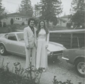
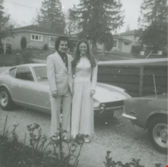
Mike Loynes and Linda
https://search.heritageburnaby.ca/link/archivedescription37673
- Repository
- City of Burnaby Archives
- Date
- 1973 (date of original), copied 1991
- Collection/Fonds
- Burnaby Historical Society fonds
- Description Level
- Item
- Physical Description
- 1 photograph : b&w ; 3.9 x 3.9 cm print on contact sheet 20.2 x 25.3 cm
- Scope and Content
- Photograph of Mike Loynes and his future wife, Linda, standing beside a car in the driveway of 1855 18th Avenue (old numbering) before attending a wedding.
- Repository
- City of Burnaby Archives
- Date
- 1973 (date of original), copied 1991
- Collection/Fonds
- Burnaby Historical Society fonds
- Subseries
- Burnaby Image Bank subseries
- Physical Description
- 1 photograph : b&w ; 3.9 x 3.9 cm print on contact sheet 20.2 x 25.3 cm
- Description Level
- Item
- Record No.
- 370-261
- Access Restriction
- No restrictions
- Reproduction Restriction
- No restrictions
- Accession Number
- BHS1999-03
- Scope and Content
- Photograph of Mike Loynes and his future wife, Linda, standing beside a car in the driveway of 1855 18th Avenue (old numbering) before attending a wedding.
- Media Type
- Photograph
- Notes
- Title based on contents of photograph
- 1 b&w copy negative accompanying
- Copied from col. photograph
- Negative has a pink cast
- Geographic Access
- 18th Avenue
- Historic Neighbourhood
- Edmonds (Historic Neighbourhood)
- Planning Study Area
- Stride Avenue Area
Images

Nichols Chemical Co. Ltd. - Drawing No. 511726
https://search.heritageburnaby.ca/link/museumdescription11393
- Repository
- Burnaby Village Museum
- Date
- 26 Jan. 1962
- Collection/Fonds
- Nichols Chemical Company fonds
- Description Level
- Item
- Physical Description
- 1 technical drawing : blueline print ; 87.5 x 111 cm
- Scope and Content
- Item consists of technical drawing titled "Assy. Det. No. 3 Ore Burner", "No. 511726" of Nichol's Chemical Plant. Includes "Parts Lists" index.
- Repository
- Burnaby Village Museum
- Collection/Fonds
- Nichols Chemical Company fonds
- Description Level
- Item
- Physical Description
- 1 technical drawing : blueline print ; 87.5 x 111 cm
- Material Details
- Scale 1:.25
- Scope and Content
- Item consists of technical drawing titled "Assy. Det. No. 3 Ore Burner", "No. 511726" of Nichol's Chemical Plant. Includes "Parts Lists" index.
- Subjects
- Buildings - Industrial - Factories
- Responsibility
- General Chemical Company
- Geographic Access
- Barnet Road
- Street Address
- 8655 Barnet Road
- Accession Code
- BV998.23.15
- Access Restriction
- No restrictions
- Reproduction Restriction
- No known restrictions
- Date
- 26 Jan. 1962
- Media Type
- Technical Drawing
- Historic Neighbourhood
- Barnet (Historic Neighbourhood)
- Planning Study Area
- Burnaby Mountain Area
- Scan Resolution
- 300
- Scan Date
- 2022-05-10
- Notes
- Title based on contents of item
- "Scale 1/4" = 1'
- Stamped with Print Date: "Jan 26 1962"
Images


Taxi Zone Sign
https://search.heritageburnaby.ca/link/archivedescription79924
- Repository
- City of Burnaby Archives
- Date
- September 24, 1976
- Collection/Fonds
- Burnaby Public Library Contemporary Visual Archive Project
- Description Level
- Item
- Physical Description
- 1 photograph : b&w ; 11 x 16 cm mounted on cardboard
- Scope and Content
- Photograph shows a taxi zone sign on a tree in the wilderness area near Kask Kamp in the 7200 block of Barnet Road.
- Repository
- City of Burnaby Archives
- Date
- September 24, 1976
- Collection/Fonds
- Burnaby Public Library Contemporary Visual Archive Project
- Physical Description
- 1 photograph : b&w ; 11 x 16 cm mounted on cardboard
- Description Level
- Item
- Record No.
- 556-495
- Access Restriction
- No restrictions
- Reproduction Restriction
- Reproduce for fair dealing purposes only
- Accession Number
- 2013-13
- Scope and Content
- Photograph shows a taxi zone sign on a tree in the wilderness area near Kask Kamp in the 7200 block of Barnet Road.
- Media Type
- Photograph
- Photographer
- Born, A. J.
- Notes
- Scope note taken directly from BPL photograph description.
- 1 b&w copy negative : 10 x 12.5 cm accompanying
- Geographic Access
- Barnet Road
- Historic Neighbourhood
- Barnet (Historic Neighbourhood)
- Planning Study Area
- Burnaby Mountain Area
Images
