Narrow Results By
Insurance Plan of the Municipality of Burnaby, B.C. Volume 1
https://search.heritageburnaby.ca/link/archivedescription71903
- Repository
- City of Burnaby Archives
- Date
- March 1964
- Collection/Fonds
- Planning Department fonds
- Description Level
- Item
- Physical Description
- 1 plan : col. ; both sides ; on 39 sheets 33 x 30 cm
- Scope and Content
- Item is volume one of the fire insurance plan for the Municipality of Burnaby for 1963, updated to 1964. This item was collected by the Burnaby Planning Department for information purposes. The Fire Insurance plans cover areas east of Boundary Road and west of Gilley Avenue with Burrard Inlet to th…
- Repository
- City of Burnaby Archives
- Date
- March 1964
- Collection/Fonds
- Planning Department fonds
- Series
- Planning General series
- Physical Description
- 1 plan : col. ; both sides ; on 39 sheets 33 x 30 cm
- Material Details
- Scale : 1 inch = 1200 feet
- Description Level
- Item
- Record No.
- 46225
- Accession Number
- 2012-15
- Scope and Content
- Item is volume one of the fire insurance plan for the Municipality of Burnaby for 1963, updated to 1964. This item was collected by the Burnaby Planning Department for information purposes. The Fire Insurance plans cover areas east of Boundary Road and west of Gilley Avenue with Burrard Inlet to the north and the Fraser River to the south.
- Media Type
- Cartographic Material
- Publisher
- Toronto, Ontario : Underwriters Survey Bureau
- Notes
- Transcribed title
Map of Greater Vancouver and Lower Mainland Area
https://search.heritageburnaby.ca/link/archivedescription65644
- Repository
- City of Burnaby Archives
- Date
- [1960]
- Collection/Fonds
- Burnaby Historical Society fonds
- Description Level
- Item
- Physical Description
- 1 map : col. ; on sheet 56 x 88 cm, folded to 19 x 10 cm + 1 p. cover ; 22 x 50 cm folded to 22 x 13 cm
- Scope and Content
- Item is a "Map of Greater Vancouver and Lower Mainland Area" with a detachable cardboard cover that lists "streets, districts, schools, churches, shopping centres, parks, etc."
- Repository
- City of Burnaby Archives
- Date
- [1960]
- Collection/Fonds
- Burnaby Historical Society fonds
- Subseries
- Municipal record subseries
- Physical Description
- 1 map : col. ; on sheet 56 x 88 cm, folded to 19 x 10 cm + 1 p. cover ; 22 x 50 cm folded to 22 x 13 cm
- Description Level
- Item
- Record No.
- 42574
- Accession Number
- BHS1995-15
- Scope and Content
- Item is a "Map of Greater Vancouver and Lower Mainland Area" with a detachable cardboard cover that lists "streets, districts, schools, churches, shopping centres, parks, etc."
- Media Type
- Cartographic Material
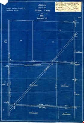
Survey made by Albert J. Hill
https://search.heritageburnaby.ca/link/museumdescription11149
- Repository
- Burnaby Village Museum
- Date
- 1885
- Collection/Fonds
- Ronald G. Scobbie collection
- Description Level
- Item
- Physical Description
- 1 survey plan : blueprint ; 43 x 30 cm
- Scope and Content
- Item consists of a "Survey" / Made by Albert J. Hill" re the north boundary of district lots 9 and 107 on the east side of North Road.
- Repository
- Burnaby Village Museum
- Collection/Fonds
- Ronald G. Scobbie collection
- Description Level
- Item
- Physical Description
- 1 survey plan : blueprint ; 43 x 30 cm
- Scope and Content
- Item consists of a "Survey" / Made by Albert J. Hill" re the north boundary of district lots 9 and 107 on the east side of North Road.
- Creator
- Hill, Albert James
- Geographic Access
- North Road
- Accession Code
- BV003.83.28
- Access Restriction
- No restrictions
- Reproduction Restriction
- No known restrictions
- Date
- 1885
- Media Type
- Cartographic Material
- Scan Resolution
- 600
- Scan Date
- 15-Jan-2021
- Scale
- 100
- Notes
- Transcribed title
- Handwritten note pasted in upper right corner reads: "This is the blue print referred to in the letter" "dated. 13. December - 1910, sent by order of the Board to Messrs W.N. Draper & Albert J. Hill" "Re: North Boundary. Lots. 9 & 107." "New Westminster District" "Corp. B.C.L. Surveyors" "Victoria. B.C." "-- Roberts" "Sec Treas & Registrar"
- Note in pencil on verso reads: “North / Road”
- Note in red crayon on verso reads: “001607”
