Narrow Results By
Subject
- Academic Disciplines
- Accidents 1
- Accidents - Automobile Accidents 2
- Accidents - Train Accidents 2
- Adornment - Jewelry 2
- Advertising Medium 2
- Advertising Medium - Signs and Signboards
- Aerial Photographs 50
- Agricultural Tools and Equipment 6
- Agricultural Tools and Equipment - Gardening Equipment 2
- Agricultural Tools and Equipment - Plows 4
- Agriculture 7

Arrow Neon Sign
https://search.heritageburnaby.ca/link/landmark861
- Repository
- Burnaby Heritage Planning
- Description
- Commercial building.
- Associated Dates
- 1961
- Other Names
- Lost in the 50's Drive-in
- Street View URL
- Google Maps Street View
- Repository
- Burnaby Heritage Planning
- Other Names
- Lost in the 50's Drive-in
- Geographic Access
- Edmonds Street
- Associated Dates
- 1961
- Description
- Commercial building.
- Heritage Value
- The Arrow Neon Sign was built in 1961 by the Neonette Sign Company of New Westminster when this property was opened as the Tomahawk Drive-in Restaurant. The restaurant was later known as Lindy's Burger and in 1990, the business was renamed Lost in the 50's Drive-in. It stands 20-foot tall and is composed of a large double-sided hollow steel panel serpentine arrow mounted on a pole supporting a lexan sign panel measuring approximately 8 feet wide by 4 feet tall. The sign was designed with three illuminated features: a round lamp at the top of the pole, a double-sided rectangular fluorescent sign panel box, and two double-sided rows of orange neon arrows that follow the large serpentine arrow. The Arrow Neon Sign remains as a rare surviving example of neon sign art in the city and is the only historic neon sign in South Burnaby. The sign has gained prominence over the years as it has been associated with this small iconic drive-in which has also been utilized as a set for film production. Additionally, the drive-in has played a prominent role in the Edmonds community as a popular setting for recent "Show and Shine" participants to park their classic cars.
- Locality
- Edmonds
- Historic Neighbourhood
- East Burnaby (Historic Neighbourhood)
- Planning Study Area
- Lakeview-Mayfield Area
- Builder
- Neonette Sign Company
- Community
- Burnaby
- Contributing Resource
- Structure
- Ownership
- Public (local)
- Street Address
- 7741 Edmonds Street
- Street View URL
- Google Maps Street View
Images


1923 Ford Touring Car
https://search.heritageburnaby.ca/link/archivedescription35542
- Repository
- City of Burnaby Archives
- Date
- 1923 (date of original), copied 1986
- Collection/Fonds
- Burnaby Historical Society fonds
- Description Level
- Item
- Physical Description
- 1 photograph : b&w ; 12.7 x 17.8 cm print
- Scope and Content
- Photograph of (left to right) Bill Anthony and Jim Warren, with a 1923 Ford touring car, Jim's first car. They became brothers-in-law when Bill married Mary Warren. The pair are about to leave on motor tour of Oregon.
- Repository
- City of Burnaby Archives
- Date
- 1923 (date of original), copied 1986
- Collection/Fonds
- Burnaby Historical Society fonds
- Subseries
- Pioneer Tales subseries
- Physical Description
- 1 photograph : b&w ; 12.7 x 17.8 cm print
- Description Level
- Item
- Record No.
- 204-400
- Access Restriction
- No restrictions
- Reproduction Restriction
- No known restrictions
- Accession Number
- BHS1988-03
- Scope and Content
- Photograph of (left to right) Bill Anthony and Jim Warren, with a 1923 Ford touring car, Jim's first car. They became brothers-in-law when Bill married Mary Warren. The pair are about to leave on motor tour of Oregon.
- Media Type
- Photograph
- Notes
- Title based on contents of photograph
Images

![3951 and 3953 Hastings Street, [1965] thumbnail](/media/hpo/_Data/_Archives_Images/_Unrestricted/316/366-014.jpg?width=280)
3951 and 3953 Hastings Street
https://search.heritageburnaby.ca/link/archivedescription37385
- Repository
- City of Burnaby Archives
- Date
- [1965]
- Collection/Fonds
- Burnaby Historical Society fonds
- Description Level
- Item
- Physical Description
- 1 photograph : b&w negative
- Scope and Content
- Photograph of the buildings at 3951 and 3953 Hastings Street. A number of business signs are visible including "Paulettes Beauty Salon" and "Norburn Secondhand Store."
- Repository
- City of Burnaby Archives
- Date
- [1965]
- Collection/Fonds
- Burnaby Historical Society fonds
- Subseries
- Municipal record subseries
- Physical Description
- 1 photograph : b&w negative
- Description Level
- Item
- Record No.
- 366-014
- Access Restriction
- No restrictions
- Reproduction Restriction
- Reproduce for fair dealing purposes only
- Accession Number
- BHS1998-12
- Scope and Content
- Photograph of the buildings at 3951 and 3953 Hastings Street. A number of business signs are visible including "Paulettes Beauty Salon" and "Norburn Secondhand Store."
- Media Type
- Photograph
- Notes
- Title based on contents of photograph
- Geographic Access
- Hastings Street
- Street Address
- 3953 Hastings Street
- 3951 Hastings Street
- Historic Neighbourhood
- Vancouver Heights (Historic Neighbourhood)
- Planning Study Area
- Burnaby Heights Area
Images
![3951 and 3953 Hastings Street, [1965] thumbnail](/media/hpo/_Data/_Archives_Images/_Unrestricted/316/366-014.jpg)
![Allen Sharpe's First Store on Kingsway, [192-] (date of original), copied 1992 thumbnail](/media/hpo/_Data/_Archives_Images/_Unrestricted/315/315-051.jpg?width=280)
Allen Sharpe's First Store on Kingsway
https://search.heritageburnaby.ca/link/archivedescription36696
- Repository
- City of Burnaby Archives
- Date
- [192-] (date of original), copied 1992
- Collection/Fonds
- Burnaby Historical Society fonds
- Description Level
- Item
- Physical Description
- 1 photograph : b&w ; 13 x 8.5 cm print
- Scope and Content
- Photograph of the exterior of Allen Sharpe's first store on Kingsway (at Kathleen Avenue), a sign shop and store that also sold groceries and Mrs. Rose Sharpe's hand-made linens. The Sharpes bought the property in 1919.
- Repository
- City of Burnaby Archives
- Date
- [192-] (date of original), copied 1992
- Collection/Fonds
- Burnaby Historical Society fonds
- Subseries
- Burnaby Centennial Anthology subseries
- Physical Description
- 1 photograph : b&w ; 13 x 8.5 cm print
- Description Level
- Item
- Record No.
- 315-051
- Access Restriction
- No restrictions
- Reproduction Restriction
- No known restrictions
- Accession Number
- BHS1994-04
- Scope and Content
- Photograph of the exterior of Allen Sharpe's first store on Kingsway (at Kathleen Avenue), a sign shop and store that also sold groceries and Mrs. Rose Sharpe's hand-made linens. The Sharpes bought the property in 1919.
- Names
- Sharpe Signs
- Media Type
- Photograph
- Notes
- Title based on contents of photograph
- Geographic Access
- Kingsway
- Kathleen Avenue
- Street Address
- 4360 Kingsway
- Historic Neighbourhood
- Central Park (Historic Neighbourhood)
- Planning Study Area
- Maywood Area
Images
![Allen Sharpe's First Store on Kingsway, [192-] (date of original), copied 1992 thumbnail](/media/hpo/_Data/_Archives_Images/_Unrestricted/315/315-051.jpg)
![Allen Sharpe's Gas Station on Kingsway, [192-] (date of original), copied 1992 thumbnail](/media/hpo/_Data/_Archives_Images/_Unrestricted/315/315-049.jpg?width=280)
Allen Sharpe's Gas Station on Kingsway
https://search.heritageburnaby.ca/link/archivedescription36694
- Repository
- City of Burnaby Archives
- Date
- [192-] (date of original), copied 1992
- Collection/Fonds
- Burnaby Historical Society fonds
- Description Level
- Item
- Physical Description
- 1 photograph : b&w ; 8.7 x 12.6 cm print
- Scope and Content
- Photograph of Allen Sharpe's gas station on Kingsway (at Kathleen Avenue) with a group of men standing in front. Mr. Sharpe is on the right wearing a cap and tie. Signs on the building read, "Sharpe Service Garage / Shell Gasoline / Motor Oil / Tires."
- Repository
- City of Burnaby Archives
- Date
- [192-] (date of original), copied 1992
- Collection/Fonds
- Burnaby Historical Society fonds
- Subseries
- Burnaby Centennial Anthology subseries
- Physical Description
- 1 photograph : b&w ; 8.7 x 12.6 cm print
- Description Level
- Item
- Record No.
- 315-049
- Access Restriction
- No restrictions
- Reproduction Restriction
- No known restrictions
- Accession Number
- BHS1994-04
- Scope and Content
- Photograph of Allen Sharpe's gas station on Kingsway (at Kathleen Avenue) with a group of men standing in front. Mr. Sharpe is on the right wearing a cap and tie. Signs on the building read, "Sharpe Service Garage / Shell Gasoline / Motor Oil / Tires."
- Names
- Sharpe Service Garage
- Media Type
- Photograph
- Notes
- Title based on contents of photograph
- Geographic Access
- Kingsway
- Street Address
- 4360 Kingsway
- Historic Neighbourhood
- Central Park (Historic Neighbourhood)
- Planning Study Area
- Maywood Area
Images
![Allen Sharpe's Gas Station on Kingsway, [192-] (date of original), copied 1992 thumbnail](/media/hpo/_Data/_Archives_Images/_Unrestricted/315/315-049.jpg)

Burnaby Players on Kingsway
https://search.heritageburnaby.ca/link/archivedescription37771
- Repository
- City of Burnaby Archives
- Date
- 1963 (date of original), copied 1991
- Collection/Fonds
- Burnaby Historical Society fonds
- Description Level
- Item
- Physical Description
- 1 photograph : b&w ; 2.6 x 4.0 cm print on contact sheet 20.3 x 26.2 cm
- Scope and Content
- Photograph of the Burnaby Players parading along Kingsway in costume. Some members are in a car with a sign reading "Burnaby Players," while others walk alongside. The photo was taken at the corner of Kingsway and Silver Avenue facing north.
- Repository
- City of Burnaby Archives
- Date
- 1963 (date of original), copied 1991
- Collection/Fonds
- Burnaby Historical Society fonds
- Subseries
- Burnaby Image Bank subseries
- Physical Description
- 1 photograph : b&w ; 2.6 x 4.0 cm print on contact sheet 20.3 x 26.2 cm
- Description Level
- Item
- Record No.
- 370-359
- Access Restriction
- No restrictions
- Reproduction Restriction
- No restrictions
- Accession Number
- BHS1999-03
- Scope and Content
- Photograph of the Burnaby Players parading along Kingsway in costume. Some members are in a car with a sign reading "Burnaby Players," while others walk alongside. The photo was taken at the corner of Kingsway and Silver Avenue facing north.
- Subjects
- Occupations - Actors
- Transportation - Automobiles
- Advertising Medium - Signs and Signboards
- Names
- Burnaby Players
- Media Type
- Photograph
- Notes
- Title based on contents of photograph
- 1 b&w copy negative accompanying
- Negative has a pink cast
- Geographic Access
- Kingsway
- Silver Avenue
- Historic Neighbourhood
- Central Park (Historic Neighbourhood)
- Planning Study Area
- Marlborough Area
Images


Central Park
https://search.heritageburnaby.ca/link/archivedescription34862
- Repository
- City of Burnaby Archives
- Date
- 1920 (date of original), photographed 1985
- Collection/Fonds
- Burnaby Historical Society fonds
- Description Level
- Item
- Physical Description
- 1 photograph : b&w ; 8.8 x 11.3 cm
- Scope and Content
- Photograph of the Central Park entrance arch with the "Central Park" electric sign. An Interurban tram can be seen on the right. This photograph used to be hung at the Central Park branch of the Burnaby Public Library.
- Repository
- City of Burnaby Archives
- Date
- 1920 (date of original), photographed 1985
- Collection/Fonds
- Burnaby Historical Society fonds
- Subseries
- Evelyn Salisbury subseries
- Physical Description
- 1 photograph : b&w ; 8.8 x 11.3 cm
- Description Level
- Item
- Record No.
- 145-010
- Access Restriction
- No restrictions
- Reproduction Restriction
- No known restrictions
- Accession Number
- BHS1985-15
- Scope and Content
- Photograph of the Central Park entrance arch with the "Central Park" electric sign. An Interurban tram can be seen on the right. This photograph used to be hung at the Central Park branch of the Burnaby Public Library.
- Subjects
- Structures - Arches
- Advertising Medium - Signs and Signboards
- Geographic Features - Parks
- Transportation - Electric Railroads
- Media Type
- Photograph
- Notes
- Title based on contents of photograph
- Geographic Access
- Central Park
- Imperial Street
- Street Address
- 3883 Imperial Street
- Historic Neighbourhood
- Central Park (Historic Neighbourhood)
- Planning Study Area
- Maywood Area
Images

![Denby Brothers Shoe Company trucks, [1921] thumbnail](/media/hpo/_Data/_BVM_Images/1977/1977_0084_0004_001.jpg?width=280)
Denby Brothers Shoe Company trucks
https://search.heritageburnaby.ca/link/museumdescription554
- Repository
- Burnaby Village Museum
- Date
- [1921]
- Collection/Fonds
- Burnaby Village Museum Photograph collection
- Description Level
- Item
- Physical Description
- 1 photograph : b&w ; 20.2 x 25.4 cm
- Scope and Content
- Photograph of two Johnston Storage Company trucks loaded with rolls and stacks of leather for Denby Brothers shoe company. Banner signs that read "for DENBY BROS & Co. Vancouver BC" hang on the sides of the trucks that are parked just outside of the Denby Brothers store. Beside the store is another…
- Repository
- Burnaby Village Museum
- Collection/Fonds
- Burnaby Village Museum Photograph collection
- Description Level
- Item
- Physical Description
- 1 photograph : b&w ; 20.2 x 25.4 cm
- Scope and Content
- Photograph of two Johnston Storage Company trucks loaded with rolls and stacks of leather for Denby Brothers shoe company. Banner signs that read "for DENBY BROS & Co. Vancouver BC" hang on the sides of the trucks that are parked just outside of the Denby Brothers store. Beside the store is another business with a sign that reads "A. Ramsay & Son Company." The street is brick laid, and to the right can be seen a large sign for The Vancouver Sun, advertised as publisher, printer, and bookbinder. Inscribed in the negative and printed on photograph, front lower right: "8160." An annotation on the back of the photo reads: "circa 1921." Stamped on the back of the photo is: "Leonard Frank / Photographic Artist / 553 Granville St. / Bay. 1029 Vancouver, B.C./ In re-ordering prints mention no. 8160."
- Geographic Access
- Vancouver
- Accession Code
- HV977.84.4
- Access Restriction
- No restrictions
- Reproduction Restriction
- No known restrictions
- Date
- [1921]
- Media Type
- Photograph
- Scan Resolution
- 600
- Scan Date
- 2023-07-11
- Photographer
- Frank, Leonard
- Notes
- Title based on contents of photograph
Images
![Denby Brothers Shoe Company trucks, [1921] thumbnail](/media/hpo/_Data/_BVM_Images/1977/1977_0084_0004_001.jpg)
![Entrance to Oasis Tourist Camp, [192-] thumbnail](/media/hpo/_Data/_BVM_Images/1977/1977_0121_0003_001.jpg?width=280)
Entrance to Oasis Tourist Camp
https://search.heritageburnaby.ca/link/museumdescription594
- Repository
- Burnaby Village Museum
- Date
- [192-]
- Collection/Fonds
- Roy Bernard Raymer fonds
- Description Level
- Item
- Physical Description
- 1 photograph : sepia ; 8.6 x 15.1 cm
- Scope and Content
- Photograph of the entrance to Oasis Tourist Camp, which is marked by a large sign put up with two posts on either side of the sign . It reads, "Tea Gardens / The Oasis / 'Rest and Refresh' / Free Tourist Camp." Further along the driveway is a smaller sign that reads: "'Welcome.' Drive In." To the…
- Repository
- Burnaby Village Museum
- Collection/Fonds
- Roy Bernard Raymer fonds
- Description Level
- Item
- Physical Description
- 1 photograph : sepia ; 8.6 x 15.1 cm
- Scope and Content
- Photograph of the entrance to Oasis Tourist Camp, which is marked by a large sign put up with two posts on either side of the sign . It reads, "Tea Gardens / The Oasis / 'Rest and Refresh' / Free Tourist Camp." Further along the driveway is a smaller sign that reads: "'Welcome.' Drive In." To the left of the entrance is a modified house building with a sign advertising for Fraser Valley ice cream placed outside the extended patio. The Oasis Tourist Camp was located at 2675 Kingsway (after 1959 address became 6105 Kingsway) in Burnaby and was owned and operated by the Raymer family.
- Names
- Oasis
- Geographic Access
- Kingsway
- Street Address
- 6105 Kingsway
- Accession Code
- HV977.121.3
- Access Restriction
- No restrictions
- Reproduction Restriction
- No known restrictions
- Date
- [192-]
- Media Type
- Photograph
- Planning Study Area
- Windsor Area
- Scan Resolution
- 600
- Scan Date
- 23-Aug-06
- Scale
- 100
- Notes
- Title based on contents of photograph
Images
![Entrance to Oasis Tourist Camp, [192-] thumbnail](/media/hpo/_Data/_BVM_Images/1977/1977_0121_0003_001.jpg)

Frances, Sean and Wendy Johnston
https://search.heritageburnaby.ca/link/archivedescription51383
- Repository
- City of Burnaby Archives
- Date
- 1962
- Collection/Fonds
- Harold H. Johnston fonds
- Description Level
- Item
- Physical Description
- 1 photograph (jpeg) : b&w
- Scope and Content
- Photograph of Frances Johnston and her two children, Sean and Wendy, seated and eating at an unidentified fast food restaurant. Numerous signs and advertisements can be seen on the windows behind the family.
- Repository
- City of Burnaby Archives
- Date
- 1962
- Collection/Fonds
- Harold H. Johnston fonds
- Physical Description
- 1 photograph (jpeg) : b&w
- Description Level
- Item
- Record No.
- 483-018
- Access Restriction
- No restrictions
- Reproduction Restriction
- No reproduction permitted
- Accession Number
- 2008-08
- Scope and Content
- Photograph of Frances Johnston and her two children, Sean and Wendy, seated and eating at an unidentified fast food restaurant. Numerous signs and advertisements can be seen on the windows behind the family.
- Media Type
- Photograph
- Photographer
- Johnston, Harold H.
- Notes
- Title based on contents of photograph
Images


Grant family home
https://search.heritageburnaby.ca/link/archivedescription36865
- Repository
- City of Burnaby Archives
- Date
- 1925
- Collection/Fonds
- Burnaby Historical Society fonds
- Description Level
- Item
- Physical Description
- 1 photograph : b&w ; 8.7 x 12.7 cm print
- Scope and Content
- Photograph of the playroom of the Grant family home at 2772 Sussex Avenue (old street numbering). In the room is a sign for the Imperial Order Daughters of the Empire (I.O.D.E.) with which Mrs. Grant was involved. Alice and George A. Grant moved here with their family in 1925.
- Repository
- City of Burnaby Archives
- Date
- 1925
- Collection/Fonds
- Burnaby Historical Society fonds
- Subseries
- Burnaby Centennial Anthology subseries
- Physical Description
- 1 photograph : b&w ; 8.7 x 12.7 cm print
- Description Level
- Item
- Record No.
- 315-323
- Access Restriction
- No restrictions
- Reproduction Restriction
- No known restrictions
- Accession Number
- BHS1994-04
- Scope and Content
- Photograph of the playroom of the Grant family home at 2772 Sussex Avenue (old street numbering). In the room is a sign for the Imperial Order Daughters of the Empire (I.O.D.E.) with which Mrs. Grant was involved. Alice and George A. Grant moved here with their family in 1925.
- Media Type
- Photograph
- Notes
- Title based on contents of photograph
- Geographic Access
- Sussex Avenue
- Kingsway
- Street Address
- 4700 Kingsway
- Historic Neighbourhood
- Central Park (Historic Neighbourhood)
- Planning Study Area
- Maywood Area
Images


Hastings Street
https://search.heritageburnaby.ca/link/archivedescription51467
- Repository
- City of Burnaby Archives
- Date
- 1968
- Collection/Fonds
- Harold H. Johnston fonds
- Description Level
- Item
- Physical Description
- 1 photograph (jpeg) : b&w
- Scope and Content
- Photograph taken looking east along Hastings Street, near Gilmore Avenue. The photograph was taken at night and a number of businesses and business signs are visible, including those for Wosk's and the Admiral Hotel (at 4125 Hastings).
- Repository
- City of Burnaby Archives
- Date
- 1968
- Collection/Fonds
- Harold H. Johnston fonds
- Physical Description
- 1 photograph (jpeg) : b&w
- Description Level
- Item
- Record No.
- 483-068
- Access Restriction
- No restrictions
- Reproduction Restriction
- No reproduction permitted
- Accession Number
- 2008-08
- Scope and Content
- Photograph taken looking east along Hastings Street, near Gilmore Avenue. The photograph was taken at night and a number of businesses and business signs are visible, including those for Wosk's and the Admiral Hotel (at 4125 Hastings).
- Names
- Admiral Hotel
- Media Type
- Photograph
- Photographer
- Johnston, Harold H.
- Notes
- Title based on contents of photograph
- Geographic Access
- Hastings Street
- Street Address
- 4125 Hastings Street
- Historic Neighbourhood
- Vancouver Heights (Historic Neighbourhood)
- Planning Study Area
- Burnaby Heights Area
Images


The Hot Dog Inn and proprietors
https://search.heritageburnaby.ca/link/archivedescription34311
- Repository
- City of Burnaby Archives
- Date
- 1924
- Collection/Fonds
- Burnaby Historical Society fonds
- Description Level
- Item
- Physical Description
- 1 photograph : b&w ; 8 x 12.9 cm on page 17.5 x 24.5 cm
- Scope and Content
- Photograph of the hot dog stand built at Deer Lake for ice skaters. Standing in front of it are the "proprietors" A. D. Bowker and Abe Rowe. The sign affixed to the stand reads: "This Is The Hot Dog Inn And It's Cold Outside / Come Right In / Coffee 5 cents / Hot Dogs 10 cents".
- Repository
- City of Burnaby Archives
- Date
- 1924
- Collection/Fonds
- Burnaby Historical Society fonds
- Subseries
- Peers family subseries
- Physical Description
- 1 photograph : b&w ; 8 x 12.9 cm on page 17.5 x 24.5 cm
- Description Level
- Item
- Record No.
- 020-018
- Access Restriction
- No restrictions
- Reproduction Restriction
- No known restrictions
- Accession Number
- BHS2007-04
- Scope and Content
- Photograph of the hot dog stand built at Deer Lake for ice skaters. Standing in front of it are the "proprietors" A. D. Bowker and Abe Rowe. The sign affixed to the stand reads: "This Is The Hot Dog Inn And It's Cold Outside / Come Right In / Coffee 5 cents / Hot Dogs 10 cents".
- Subjects
- Buildings - Commercial - Restaurants
- Structures - Tents
- Advertising Medium - Signs and Signboards
- Names
- Bowker, A.D.
- Rowe, Abe
- Media Type
- Photograph
- Notes
- Title based on caption accompanying photograph
- Geographic Access
- Deer Lake
- Historic Neighbourhood
- Burnaby Lake (Historic Neighbourhood)
- Planning Study Area
- Morley-Buckingham Area
Images

Interview with Ron Baker by Kathy Bossort November 27, 2015 - Track 1
https://search.heritageburnaby.ca/link/oralhistory635
- Repository
- City of Burnaby Archives
- Date Range
- 1963-1965
- Length
- 0:18:05
- Summary
- This portion of the interview is about Dr. Ron Baker’s stories about the beginnings of Simon Fraser University, how he became involved, and the attraction of being able to try different things with little interference. He talks about SFU Chancellor Gordon Shrum’s ideas for all year quarter system a…
- Repository
- City of Burnaby Archives
- Summary
- This portion of the interview is about Dr. Ron Baker’s stories about the beginnings of Simon Fraser University, how he became involved, and the attraction of being able to try different things with little interference. He talks about SFU Chancellor Gordon Shrum’s ideas for all year quarter system and for large lecture/small tutorials, and his counter proposal for a trimester system. He also describes his working relationship with Dr. Shrum.
- Date Range
- 1963-1965
- Length
- 0:18:05
- Geographic Access
- Burnaby Mountain Conservation Area
- Interviewer
- Bossort, Kathy
- Interview Date
- November 27, 2015
- Scope and Content
- Recording is of an interview with Dr. Ronald James Baker conducted by Kathy Bossort. Ron Baker was one of 23 participants interviewed as part of the Community Heritage Commission’s Burnaby Mountain Oral History Project. The interview is mainly about the founding of Simon Fraser University from the perspective of SFU’s first faculty member and Director of Academic Planning, Ron Baker. Ron Baker talks about John B. Macdonald’s report on higher education in BC (1962) and how it lead to the provincial government’s decision to establish a new university and to put it in the Burnaby area. He tells stories about how the site on Burnaby Mountain was chosen; about the building of the campus; and about the challenges of planning the academic structure of the university. He also talks about the attraction of creating with little interference an institution trying out new ideas and tells stories about his working relationship with Gordon Shrum. He considers the problems created by building universities in out of the way places and the ideas such as UniverCity for dealing with SFU’s isolation.
- Biographical Notes
- Ron Baker was born in London, England, in 1924, and served in the Royal Air Force during WW2. He emigrated to Canada in 1947 and studied at UBC where he obtained a BA degree (1951) and MA degree (1953) in English Language and Literature. He served on the faculty of the UBC English Department beginning as a lecturer in 1951 and advanced to positions of Assistant Professor (1958-63) and Associate Professor (1963-65). He was a contributor to John B. Macdonald’s 1962 report “Higher Education in British Columbia and a Plan for the Future”, and continued to make significant contributions to the establishment of the community college system in Canada throughout his career. In 1963 the newly established Simon Fraser University hired Ron as its first Director of Academic Planning, serving also as first head of SFU’s English Department. In 1969 Ron left SFU to become the first President of the University of Prince Edward Island, a position he held until 1978. In 1978 he was made an Officer of the Order of Canada for his contributions to higher education. Ron has contributed to many organizations, including serving as a member of the Board of Directors of the Association of Universities and Colleges of Canada, on Canada Council, and as President of Association of Atlantic Universities and the Association of Canadian University Teachers of English. In 1990 Ron Baker was asked by the government of BC to prepare a preliminary report on the establishment of the future UNBC in Prince George. Now retired Ron Baker lives in the Edmonds area of Burnaby.
- Total Tracks
- 7
- Total Length
- 1:33:46
- Interviewee Name
- Baker, Ronald J. "Ron"
- Interview Location
- Ron Baker's home in Burnaby
- Interviewer Bio
- Kathy Bossort is a retired archivist living in Ladner, BC. She worked at the Delta Museum and Archives after graduating from SLAIS (UBC) in 2001 with Masters degrees in library science and archival studies. Kathy grew up in Calgary, Alberta, and, prior to this career change, she lived in the West Kootenays, earning her living as a cook for BC tourist lodges and work camps. She continues to be interested in oral histories as a way to fill the gaps in the written record and bring richer meaning to history.
- Collection/Fonds
- Community Heritage Commission Special Projects fonds
- Media Type
- Sound Recording
Audio Tracks
Track one of interview with Dr. Ron Baker
Track one of interview with Dr. Ron Baker
https://search.heritageburnaby.ca/media/hpo/_Data/_Archives_Oral_Histories/_Unrestricted/MSS196-013/MSS196-013_Track_1.mp3Interview with Ron Baker by Kathy Bossort November 27, 2015 - Track 4
https://search.heritageburnaby.ca/link/oralhistory638
- Repository
- City of Burnaby Archives
- Date Range
- 1963-1970
- Length
- 0:11:00
- Summary
- This portion of the interview is about Dr. Ron Baker talking about Dr. Shrum’s attraction to the mountain top as site for university and his grand ideas for the university, including scholarships for an athletic program. He also talks about how original SFU faculty was more West Point Grey centered…
- Repository
- City of Burnaby Archives
- Summary
- This portion of the interview is about Dr. Ron Baker talking about Dr. Shrum’s attraction to the mountain top as site for university and his grand ideas for the university, including scholarships for an athletic program. He also talks about how original SFU faculty was more West Point Grey centered and preferred to commute from the North shore, and how this changed for new faculty who settled in Burnaby and Coquitlam.
- Date Range
- 1963-1970
- Length
- 0:11:00
- Subjects
- Academic Disciplines
- Planning
- Transportation
- Geographic Access
- Burnaby Mountain Conservation Area
- Interviewer
- Bossort, Kathy
- Interview Date
- November 27, 2015
- Scope and Content
- Recording is of an interview with Dr. Ronald James Baker conducted by Kathy Bossort. Ron Baker was one of 23 participants interviewed as part of the Community Heritage Commission’s Burnaby Mountain Oral History Project. The interview is mainly about the founding of Simon Fraser University from the perspective of SFU’s first faculty member and Director of Academic Planning, Ron Baker. Ron Baker talks about John B. Macdonald’s report on higher education in BC (1962) and how it lead to the provincial government’s decision to establish a new university and to put it in the Burnaby area. He tells stories about how the site on Burnaby Mountain was chosen; about the building of the campus; and about the challenges of planning the academic structure of the university. He also talks about the attraction of creating with little interference an institution trying out new ideas and tells stories about his working relationship with Gordon Shrum. He considers the problems created by building universities in out of the way places and the ideas such as UniverCity for dealing with SFU’s isolation.
- Biographical Notes
- Ron Baker was born in London, England, in 1924, and served in the Royal Air Force during WW2. He emigrated to Canada in 1947 and studied at UBC where he obtained a BA degree (1951) and MA degree (1953) in English Language and Literature. He served on the faculty of the UBC English Department beginning as a lecturer in 1951 and advanced to positions of Assistant Professor (1958-63) and Associate Professor (1963-65). He was a contributor to John B. Macdonald’s 1962 report “Higher Education in British Columbia and a Plan for the Future”, and continued to make significant contributions to the establishment of the community college system in Canada throughout his career. In 1963 the newly established Simon Fraser University hired Ron as its first Director of Academic Planning, serving also as first head of SFU’s English Department. In 1969 Ron left SFU to become the first President of the University of Prince Edward Island, a position he held until 1978. In 1978 he was made an Officer of the Order of Canada for his contributions to higher education. Ron has contributed to many organizations, including serving as a member of the Board of Directors of the Association of Universities and Colleges of Canada, on Canada Council, and as President of Association of Atlantic Universities and the Association of Canadian University Teachers of English. In 1990 Ron Baker was asked by the government of BC to prepare a preliminary report on the establishment of the future UNBC in Prince George. Now retired Ron Baker lives in the Edmonds area of Burnaby.
- Total Tracks
- 7
- Total Length
- 1:33:46
- Interviewee Name
- Baker, Ronald J. "Ron"
- Interview Location
- Ron Baker's home in Burnaby
- Interviewer Bio
- Kathy Bossort is a retired archivist living in Ladner, BC. She worked at the Delta Museum and Archives after graduating from SLAIS (UBC) in 2001 with Masters degrees in library science and archival studies. Kathy grew up in Calgary, Alberta, and, prior to this career change, she lived in the West Kootenays, earning her living as a cook for BC tourist lodges and work camps. She continues to be interested in oral histories as a way to fill the gaps in the written record and bring richer meaning to history.
- Collection/Fonds
- Community Heritage Commission Special Projects fonds
- Media Type
- Sound Recording
Audio Tracks
Track four of interview with Dr. Ron Baker
Track four of interview with Dr. Ron Baker
https://search.heritageburnaby.ca/media/hpo/_Data/_Archives_Oral_Histories/_Unrestricted/MSS196-013/MSS196-013_Track_4.mp3Interview with Ron Baker by Kathy Bossort November 27, 2015 - Track 5
https://search.heritageburnaby.ca/link/oralhistory639
- Repository
- City of Burnaby Archives
- Date Range
- 1963-1968
- Length
- 0:15:36
- Summary
- This portion of the interview is about Dr. Ron Baker’s description of the attraction SFU had for mature students; the reasons for making courses in languages, etc. non-compulsory; the pressure from the public in Burnaby and elsewhere to offer certain kinds of courses. He talks about the desire expr…
- Repository
- City of Burnaby Archives
- Summary
- This portion of the interview is about Dr. Ron Baker’s description of the attraction SFU had for mature students; the reasons for making courses in languages, etc. non-compulsory; the pressure from the public in Burnaby and elsewhere to offer certain kinds of courses. He talks about the desire expressed for theological courses and how he responded.
- Date Range
- 1963-1968
- Length
- 0:15:36
- Names
- Simon Fraser University
- Subjects
- Academic Disciplines
- Planning
- Geographic Access
- Burnaby Mountain Conservation Area
- Interviewer
- Bossort, Kathy
- Interview Date
- November 27, 2015
- Scope and Content
- Recording is of an interview with Dr. Ronald James Baker conducted by Kathy Bossort. Ron Baker was one of 23 participants interviewed as part of the Community Heritage Commission’s Burnaby Mountain Oral History Project. The interview is mainly about the founding of Simon Fraser University from the perspective of SFU’s first faculty member and Director of Academic Planning, Ron Baker. Ron Baker talks about John B. Macdonald’s report on higher education in BC (1962) and how it lead to the provincial government’s decision to establish a new university and to put it in the Burnaby area. He tells stories about how the site on Burnaby Mountain was chosen; about the building of the campus; and about the challenges of planning the academic structure of the university. He also talks about the attraction of creating with little interference an institution trying out new ideas and tells stories about his working relationship with Gordon Shrum. He considers the problems created by building universities in out of the way places and the ideas such as UniverCity for dealing with SFU’s isolation.
- Biographical Notes
- Ron Baker was born in London, England, in 1924, and served in the Royal Air Force during WW2. He emigrated to Canada in 1947 and studied at UBC where he obtained a BA degree (1951) and MA degree (1953) in English Language and Literature. He served on the faculty of the UBC English Department beginning as a lecturer in 1951 and advanced to positions of Assistant Professor (1958-63) and Associate Professor (1963-65). He was a contributor to John B. Macdonald’s 1962 report “Higher Education in British Columbia and a Plan for the Future”, and continued to make significant contributions to the establishment of the community college system in Canada throughout his career. In 1963 the newly established Simon Fraser University hired Ron as its first Director of Academic Planning, serving also as first head of SFU’s English Department. In 1969 Ron left SFU to become the first President of the University of Prince Edward Island, a position he held until 1978. In 1978 he was made an Officer of the Order of Canada for his contributions to higher education. Ron has contributed to many organizations, including serving as a member of the Board of Directors of the Association of Universities and Colleges of Canada, on Canada Council, and as President of Association of Atlantic Universities and the Association of Canadian University Teachers of English. In 1990 Ron Baker was asked by the government of BC to prepare a preliminary report on the establishment of the future UNBC in Prince George. Now retired Ron Baker lives in the Edmonds area of Burnaby.
- Total Tracks
- 7
- Total Length
- 1:33:46
- Interviewee Name
- Baker, Ronald J. "Ron"
- Interview Location
- Ron Baker's home in Burnaby
- Interviewer Bio
- Kathy Bossort is a retired archivist living in Ladner, BC. She worked at the Delta Museum and Archives after graduating from SLAIS (UBC) in 2001 with Masters degrees in library science and archival studies. Kathy grew up in Calgary, Alberta, and, prior to this career change, she lived in the West Kootenays, earning her living as a cook for BC tourist lodges and work camps. She continues to be interested in oral histories as a way to fill the gaps in the written record and bring richer meaning to history.
- Collection/Fonds
- Community Heritage Commission Special Projects fonds
- Media Type
- Sound Recording
Audio Tracks
Track five of interview with Dr. Ron Baker
Track five of interview with Dr. Ron Baker
https://search.heritageburnaby.ca/media/hpo/_Data/_Archives_Oral_Histories/_Unrestricted/MSS196-013/MSS196-013_Track_5.mp3![Jubilee Avenue, [192-] (date of original), copied 1986 thumbnail](/media/hpo/_Data/_Archives_Images/_Unrestricted/126/187-002.jpg?width=280)
Jubilee Avenue
https://search.heritageburnaby.ca/link/archivedescription35069
- Repository
- City of Burnaby Archives
- Date
- [192-] (date of original), copied 1986
- Collection/Fonds
- Burnaby Historical Society fonds
- Description Level
- Item
- Physical Description
- 1 photograph : b&w ; 11.4 x 7.1 cm
- Scope and Content
- Photograph of stores on Jubilee Avenue looking north from Imperial Street (later the location of Bonsor Park, 6550 Bonsor Avenue). Signs visible read; "Jubilee Drug Store," "Drugs," "Jubilee [Mercantile?] Co. / Groceries," "Nabob Tea," and "[Carvers or Corvers]." An accompanying description in the…
- Repository
- City of Burnaby Archives
- Date
- [192-] (date of original), copied 1986
- Collection/Fonds
- Burnaby Historical Society fonds
- Subseries
- Heyworth family subseries
- Physical Description
- 1 photograph : b&w ; 11.4 x 7.1 cm
- Description Level
- Item
- Record No.
- 187-002
- Access Restriction
- No restrictions
- Reproduction Restriction
- No known restrictions
- Accession Number
- BHS1986-38
- Scope and Content
- Photograph of stores on Jubilee Avenue looking north from Imperial Street (later the location of Bonsor Park, 6550 Bonsor Avenue). Signs visible read; "Jubilee Drug Store," "Drugs," "Jubilee [Mercantile?] Co. / Groceries," "Nabob Tea," and "[Carvers or Corvers]." An accompanying description in the accession file states that a man named Pat Flannagan ran the grocery.
- Media Type
- Photograph
- Notes
- Title based on contents of photograph
- Stamp on verso of photograph reads: "5272"
- Geographic Access
- Jubilee Avenue
- Bonsor Avenue
- Street Address
- 6550 Bonsor Avenue
- Historic Neighbourhood
- Central Park (Historic Neighbourhood)
- Planning Study Area
- Marlborough Area
Images
![Jubilee Avenue, [192-] (date of original), copied 1986 thumbnail](/media/hpo/_Data/_Archives_Images/_Unrestricted/126/187-002.jpg)
Kiddieland
https://search.heritageburnaby.ca/link/archivedescription51395
- Repository
- City of Burnaby Archives
- Date
- 1964
- Collection/Fonds
- Harold H. Johnston fonds
- Description Level
- Item
- Physical Description
- 1 photograph (jpeg) : b&w
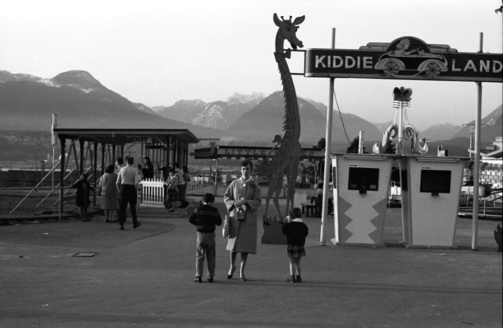
- Scope and Content
- Photograph of Frances Johnston and her children Sean and Wendy standing underneath a sign for "Kiddieland" at Playland in Vancouver. A large, giraffe-shaped signboard can be seen next to the entrance booths and a number of amusement rides are visible in the background.
- Repository
- City of Burnaby Archives
- Date
- 1964
- Collection/Fonds
- Harold H. Johnston fonds
- Physical Description
- 1 photograph (jpeg) : b&w
- Description Level
- Item
- Record No.
- 483-030
- Access Restriction
- No restrictions
- Reproduction Restriction
- No reproduction permitted
- Accession Number
- 2008-08
- Scope and Content
- Photograph of Frances Johnston and her children Sean and Wendy standing underneath a sign for "Kiddieland" at Playland in Vancouver. A large, giraffe-shaped signboard can be seen next to the entrance booths and a number of amusement rides are visible in the background.
- Media Type
- Photograph
- Photographer
- Johnston, Harold H.
- Notes
- Title based on contents of photograph
Images

Kingsway
https://search.heritageburnaby.ca/link/archivedescription34510
- Repository
- City of Burnaby Archives
- Date
- 1920
- Collection/Fonds
- Burnaby Historical Society fonds
- Description Level
- Item
- Physical Description
- 1 photograph : sepia ; 12.6 x 17.7 cm
- Scope and Content
- Photograph of Kingsway looking east at Boundary Road. A sign on the right reads, "Burnaby / Vehicles must slow down at all schools and intersections marked thus: X." A sign on a building at the left reads, "Arctic Ice Cream." Central Park is on the right.
- Repository
- City of Burnaby Archives
- Date
- 1920
- Collection/Fonds
- Burnaby Historical Society fonds
- Subseries
- Photographs subseries
- Physical Description
- 1 photograph : sepia ; 12.6 x 17.7 cm
- Description Level
- Item
- Record No.
- 031-001
- Access Restriction
- No restrictions
- Reproduction Restriction
- No known restrictions
- Accession Number
- BHS2007-04
- Scope and Content
- Photograph of Kingsway looking east at Boundary Road. A sign on the right reads, "Burnaby / Vehicles must slow down at all schools and intersections marked thus: X." A sign on a building at the left reads, "Arctic Ice Cream." Central Park is on the right.
- Media Type
- Photograph
- Notes
- Title based on contents of photograph
- Geographic Access
- Kingsway
- Central Park
- Boundary Road
- Historic Neighbourhood
- Central Park (Historic Neighbourhood)
- Planning Study Area
- Garden Village Area
- Maywood Area
Images


Kingsway
https://search.heritageburnaby.ca/link/archivedescription34511
- Repository
- City of Burnaby Archives
- Date
- 1920
- Collection/Fonds
- Burnaby Historical Society fonds
- Description Level
- Item
- Physical Description
- 1 photograph : sepia ; 12.6 x 17.6 cm
- Scope and Content
- Photograph of Kingsway looking east at Boundary Road. A sign on the right reads, "Burnaby / Vehicles must slow down at all schools and intersections marked thus: X." A sign on a building at the left reads, "Arctic Ice Cream." Central Park is on the right.
- Repository
- City of Burnaby Archives
- Date
- 1920
- Collection/Fonds
- Burnaby Historical Society fonds
- Subseries
- Photographs subseries
- Physical Description
- 1 photograph : sepia ; 12.6 x 17.6 cm
- Description Level
- Item
- Record No.
- 031-002
- Access Restriction
- No restrictions
- Reproduction Restriction
- No known restrictions
- Accession Number
- BHS2007-04
- Scope and Content
- Photograph of Kingsway looking east at Boundary Road. A sign on the right reads, "Burnaby / Vehicles must slow down at all schools and intersections marked thus: X." A sign on a building at the left reads, "Arctic Ice Cream." Central Park is on the right.
- Subjects
- Geographic Features - Roads
- Advertising Medium - Signs and Signboards
- Transportation - Automobiles
- Media Type
- Photograph
- Notes
- Title based on contents of photograph
- Geographic Access
- Kingsway
- Central Park
- Boundary Road
- Historic Neighbourhood
- Central Park (Historic Neighbourhood)
- Planning Study Area
- Garden Village Area
- Maywood Area
Images
