Narrow Results By
Decade
- 2020s 261
- 2010s 388
- 2000s 895
- 1990s 967
- 1980s 939
- 1970s 1548
- 1960s 694
- 1950s 906
- 1940s 793
- 1930s 676
- 1920s 698
- 1910s 746
- 1900s 266
- 1890s
- 1880s 58
- 1870s 9
- 1860s 5
- 1850s 4
- 1840s 1
- 1830s 1
- 1820s 1
- 1810s 1
- 1800s
- 1790s 1
- 1780s 1
- 1770s 1
- 1760s 1
- 1750s 1
- 1740s 1
- 1730s 1
- 1720s 1
- 1710s 1
- 1700s 1
- 1690s 1
- 1680s 1
- 1670s 1
- 1660s 1
- 1650s
- 1640s 1
- 1630s 1
- 1620s 1
- 1610s 1
- 1600s 1
- 1520s 1
Subject
- Agriculture - Fruit and Berries 1
- Animals - Dogs 1
- Buildings 1
- Buildings - Civic - City Halls 1
- Buildings - Commercial - Grocery Stores 1
- Buildings - Commercial - Hotels and Motels 1
- Buildings - Commercial - Stores 1
- Buildings Components - Fireplaces 1
- Buildings - Industrial - Factories 2
- Buildings - Industrial - Powerhouses 1
- Buildings - Industrial - Saw Mills 1
- Buildings - Industrial - Sawmills 1
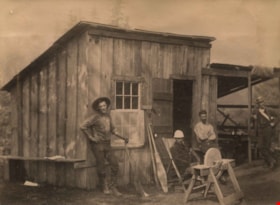
Four men in front of a cabin
https://search.heritageburnaby.ca/link/archivedescription39513
- Repository
- City of Burnaby Archives
- Date
- 1890
- Collection/Fonds
- Peers Family and Hill Family fonds
- Description Level
- Item
- Physical Description
- 1 photograph : b&w ; 9.8 x 13.5 cm on page 21.5 x 28 cm (pasted in album)
- Scope and Content
- Photograph of four men in front of a cabin. The man sitting behind the grindstone is Claude Hill. This cabin was most likely Claude Hill's residence in Murrayville (Langley) near the United States border where he lived during the late 1880s and early 1890s. Another later Burnaby resident, Charles …
- Repository
- City of Burnaby Archives
- Date
- 1890
- Collection/Fonds
- Peers Family and Hill Family fonds
- Physical Description
- 1 photograph : b&w ; 9.8 x 13.5 cm on page 21.5 x 28 cm (pasted in album)
- Description Level
- Item
- Record No.
- 477-832
- Access Restriction
- No restrictions
- Reproduction Restriction
- No known restrictions
- Accession Number
- 2007-12
- Scope and Content
- Photograph of four men in front of a cabin. The man sitting behind the grindstone is Claude Hill. This cabin was most likely Claude Hill's residence in Murrayville (Langley) near the United States border where he lived during the late 1880s and early 1890s. Another later Burnaby resident, Charles Sprott also lived in that area but both men eventually relocated to Burnaby.
- Subjects
- Buildings - Residential - Cabins
- Media Type
- Photograph
- Notes
- Title based on caption accompanying photograph
Images
![Interior of the Patterson house, [189-?] (date of original), copied 1977 thumbnail](/media/hpo/_Data/_BVM_Images/1977/1977_0099_0022_001.jpg?width=280)
Interior of the Patterson house
https://search.heritageburnaby.ca/link/museumdescription580
- Repository
- Burnaby Village Museum
- Date
- [189-?] (date of original), copied 1977
- Collection/Fonds
- Burnaby Village Museum Photograph collection
- Description Level
- Item
- Physical Description
- 1 photograph : b&w ; 20.2 x 25.2 cm print
- Scope and Content
- Photograph of a house identified by accession register, catalogue record and inscription as the Patterson house, possibly built in 1890s. This house was located either on Patterson Street (where the family first lived in Burnaby) or Edmonds Street (where they later moved to). The photograph is ta…
- Repository
- Burnaby Village Museum
- Collection/Fonds
- Burnaby Village Museum Photograph collection
- Description Level
- Item
- Physical Description
- 1 photograph : b&w ; 20.2 x 25.2 cm print
- Scope and Content
- Photograph of a house identified by accession register, catalogue record and inscription as the Patterson house, possibly built in 1890s. This house was located either on Patterson Street (where the family first lived in Burnaby) or Edmonds Street (where they later moved to). The photograph is taken from a living room, looking towards a reading room. The living room has a fireplace with a mantle decorated with framed photographs. Through a wide doorway is shown a reading room with long drapes over the window, a piano, and a chair with an antimacassar. An annotation on the back of the photo reads: "Interior of Pateron [sic] home. / Located on Edmonds or Pateron [sic] St. ? / Built 1890's."
- Accession Code
- HV977.99.22
- Access Restriction
- No restrictions
- Reproduction Restriction
- May be restricted by third party rights
- Date
- [189-?] (date of original), copied 1977
- Media Type
- Photograph
- Scan Resolution
- 600
- Scan Date
- 2023-07-11
- Notes
- Title based on contents of photograph
Images
![Interior of the Patterson house, [189-?] (date of original), copied 1977 thumbnail](/media/hpo/_Data/_BVM_Images/1977/1977_0099_0022_001.jpg)

Interview with Alfred Bingham June 10, 1975 - Track 1
https://search.heritageburnaby.ca/link/oralhistory58
- Repository
- City of Burnaby Archives
- Date Range
- 1892-1919
- Length
- 0:07:22
- Summary
- This portion of the interview pertains to Alfred Bingham's memories of his first years in the Lochdale district of Burnaby, including his first job building a sawmill on Burnaby Lake.
- Repository
- City of Burnaby Archives
- Summary
- This portion of the interview pertains to Alfred Bingham's memories of his first years in the Lochdale district of Burnaby, including his first job building a sawmill on Burnaby Lake.
- Date Range
- 1892-1919
- Photo Info
- Alfred Bingham, April 20, 1947. Item no. 010-066
- Length
- 0:07:22
- Historic Neighbourhood
- Burnaby Lake (Historic Neighbourhood)
- Interviewer
- Bradbury, Dr. Bettina
- Interview Date
- June 10, 1975
- Scope and Content
- Recording is a taped interview with Alfred Bingham by SFU graduate student Bettina Bradbury June 10, 1975. Major themes discussed are: the Depression, Pioneers, and the Co-operative Movement. To view "Narrow By" terms for each track expand this description and see "Notes".
- Biographical Notes
- Alfred "Alf" Bingham was born in England in 1892 and moved to Canada in 1912. His first job in Canada was laying track for the Grand Trunk Pacific Railway (GTPR) from Edmonton to McBride in 1912. His second was in Vancouver at the Rat Portage Mill on False Creek, working on the Resaw machine. He quit after one week due to poor working conditions. After taking part in the 1919 Winnipeg General Strike as a delegate of the Retail and Mailorder Union (A.F.L.) on the Winnipeg Trades and Labour Council, Alfred moved to Burnaby where he and fellow Burnaby residents Angus McLean and Percy Little worked ten hour days to build a Shingle Mill on the edge of Burnaby Lake for Simpson & Giberson. George Green, carpenter and millwright (author of “The History of Burnaby”) also helped in the construction of the mill. Alfred built his own home from lumber cut from the mill in the Lochdale area on Sherlock Street between Curtis Street and Kitchener Street. On April 10, 1920 Alfred married Mary Jane “Ada” Reynolds. Alfred and Ada often took in foster children during their marriage. Due to her nursing experience, Ada was often called upon to deliver babies in the Burnaby area. Alfred and Ada Bingham were instrumental members of the Army of the Common Good, collecting vegetables and grains from growers in the area and even producing over 125 tons of vegetables from its own gardens to feed children and youth suffering from the lack of resources during the Depression years. The army was in operation for ten years and during that time the members organised the Credit Union movement of British Columbia and drew up the Credit Union act thorough the Vancouver Co-operative Council. They also started Co-Op stores and the Co-Op Wholesale Society. Alfred was also Secretary of the Burnaby Housing committee and in 1946 he became the Secretary of the North Burnaby Labour Progressive Party (LPP). Mary Jane “Ada” (Reynolds) Bingham died on August 9, 1969. Her husband Alfred died on April 29, 1979.
- Total Tracks
- 14
- Total Length
- 1:57:27
- Interviewee Name
- Bingham, Alfred "Alf"
- Interviewer Bio
- Bettina Bradbury teaches history and women's studies at York University. She is the author of Wife to Widow. Lives, Laws and Politics in Nineteenth-century Montreal. (Vancouver: University of British Columbia Press, June 2011), 520p; Working Families. Age, Gender and Daily Survival in Industrializing Montreal. (Toronto: Canadian Social History Series, McClelland and Stewart, 1993); (Republished Toronto: Oxford University Press, 1996) (3rd edition, Toronto: University of Toronto Press, 2007). These interviews were undertaken after she completed her MA at Simon Fraser University in 1975 with the support of an LIP grant.
- Collection/Fonds
- Burnaby Historical Society fonds
- Subseries
- Oral history subseries
- Media Type
- Sound Recording
- Web Notes
- Interview was digitized in 2010 allowing it to be accessible on Heritage Burnaby. The digitization project was initiated by the Community Heritage Commission with support from City of Burnaby Council and the BC History Digitization Program of the Irving K. Barber Learning Centre, University of British Columbia. It was recognized by the Heritage Society of BC with an award in 2012.
Images

Audio Tracks
Track one of interview with Alfred Bingham
Track one of interview with Alfred Bingham
https://search.heritageburnaby.ca/media/hpo/_Data/_Archives_Oral_Histories/_Unrestricted/100-13-20-1/100-13-20-1_Track_1.mp3Interview with Kathleen Rose July 14, 1975 - Track 1
https://search.heritageburnaby.ca/link/oralhistory146
- Repository
- City of Burnaby Archives
- Date Range
- 1897-1934
- Length
- 0:10:37
- Summary
- This portion of the interview pertains to Kathleen Rose's first memories of coming to North Burnaby as well as of her husband's employment. She discusses quilt-making among families experiencing economic hardship.
- Repository
- City of Burnaby Archives
- Summary
- This portion of the interview pertains to Kathleen Rose's first memories of coming to North Burnaby as well as of her husband's employment. She discusses quilt-making among families experiencing economic hardship.
- Date Range
- 1897-1934
- Length
- 0:10:37
- Subjects
- Buildings - Residences - Houses
- Geographic Access
- Albert Street
- Historic Neighbourhood
- Capitol Hill (Historic Neighbourhood)
- Planning Study Area
- Capitol Hill Area
- Interviewer
- Bradbury, Dr. Bettina
- Interview Date
- July 14, 1975
- Scope and Content
- Recording is of an interview with Kathleen Rose by SFU (Simon Fraser University) student Bettina Bradbury, July 14, 1975. Major theme discussed is: the Depression.
- Biographical Notes
- Kathleen Rose was born in Dublin, Ireland in 1897 and immigrated to Prince Albert, Saskatchewan in 1907 with her family. Kathleen lived on the Prairie for eighteen years before getting married in 1923 and moving to Burnaby to be with her husband. The couple moved to the 4600 block of Albert Street in North Burnaby, where Kathleen’s husband cleared all of the land by hand. The Roses had help putting in the foundation but otherwise built their house themselves. Kathleen’s husband was a longshoreman at that time. They had a son, born in 1925, who suffered from rheumatic fever during the Depression.
- Total Tracks
- 4
- Total Length
- 0:35:42
- Interviewee Name
- Rose, Kathleen
- Interviewer Bio
- Bettina Bradbury teaches history and women's studies at York University. She is the author of Wife to Widow. Lives, Laws and Politics in Nineteenth-century Montreal. (Vancouver: University of British Columbia Press, June 2011), 520p; Working Families. Age, Gender and Daily Survival in Industrializing Montreal. (Toronto: Canadian Social History Series, McClelland and Stewart, 1993); (Republished Toronto: Oxford University Press, 1996) (3rd edition, Toronto: University of Toronto Press, 2007). These interviews were undertaken after she completed her MA at Simon Fraser University in 1975 with the support of an LIP grant.
- Collection/Fonds
- Burnaby Historical Society fonds
- Subseries
- Oral history subseries
- Media Type
- Sound Recording
- Web Notes
- Interview was digitized in 2010 allowing it to be accessible on Heritage Burnaby. The digitization project was initiated by the Community Heritage Commission with support from City of Burnaby Council and the BC History Digitization Program of the Irving K. Barber Learning Centre, University of British Columbia. It was recognized by the Heritage Society of BC with an award in 2012.
Audio Tracks
Track one of interview with Kathleen Rose
Track one of interview with Kathleen Rose
https://search.heritageburnaby.ca/media/hpo/_Data/_Archives_Oral_Histories/_Unrestricted/100-13-21/100-13-21_Track_1.mp3![Jesse Love farmhouse, [between 1893 and 1897] (date of original), copied 1998 thumbnail](/media/hpo/_Data/_BVM_Images/2000/200000450002.jpg?width=280)
Jesse Love farmhouse
https://search.heritageburnaby.ca/link/museumdescription1551
- Repository
- Burnaby Village Museum
- Date
- [between 1893 and 1897] (date of original), copied 1998
- Collection/Fonds
- Love family fonds
- Description Level
- Item
- Physical Description
- 1 photograph : b&w ; 19 x 25 cm print
- Scope and Content
- Photograph of the Jesse Love farmhouse. The Love farmhouse was located at 1390 Cumberland Road (after 1960- address was changed to 7651 Cumberland Street). The Love farmhouse was relocated to the site of the Burnaby Village Museum in 1988 where it was restored to the 1920s era.
- Repository
- Burnaby Village Museum
- Collection/Fonds
- Love family fonds
- Description Level
- Item
- Physical Description
- 1 photograph : b&w ; 19 x 25 cm print
- Scope and Content
- Photograph of the Jesse Love farmhouse. The Love farmhouse was located at 1390 Cumberland Road (after 1960- address was changed to 7651 Cumberland Street). The Love farmhouse was relocated to the site of the Burnaby Village Museum in 1988 where it was restored to the 1920s era.
- Subjects
- Buildings - Residential - Houses
- Geographic Access
- Cumberland Street
- Street Address
- 7651 Cumberland Street
- Accession Code
- BV000.45.2
- Access Restriction
- No restrictions
- Date
- [between 1893 and 1897] (date of original), copied 1998
- Media Type
- Photograph
- Historic Neighbourhood
- East Burnaby (Historic Neighbourhood)
- Planning Study Area
- Cariboo-Armstrong Area
- Scan Resolution
- 600
- Scan Date
- 09-Jun-09
- Scale
- 100
- Notes
- Title based on note on verso of photograph
- Note in pencil on verso of photograph reads: "Jesse Love Farmhouse"
Images
![Jesse Love farmhouse, [between 1893 and 1897] (date of original), copied 1998 thumbnail](/media/hpo/_Data/_BVM_Images/2000/200000450002.jpg)
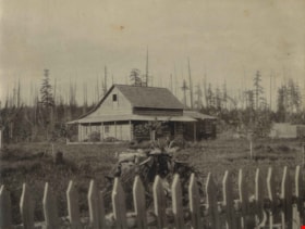
Kirby Cottage
https://search.heritageburnaby.ca/link/archivedescription39579
- Repository
- City of Burnaby Archives
- Date
- 1892
- Collection/Fonds
- Peers Family and Hill Family fonds
- Description Level
- Item
- Physical Description
- 1 photograph : b&w ; 7.2 x 9.4 cm on page 21.5 x 28 cm (pasted in album)
- Scope and Content
- Photograph of a cottage identified as the Kirby cottage in Whonnock, BC. A fence is seen in the foreground and cleared land can be seen in the background.
- Repository
- City of Burnaby Archives
- Date
- 1892
- Collection/Fonds
- Peers Family and Hill Family fonds
- Physical Description
- 1 photograph : b&w ; 7.2 x 9.4 cm on page 21.5 x 28 cm (pasted in album)
- Description Level
- Item
- Record No.
- 477-898
- Access Restriction
- No restrictions
- Reproduction Restriction
- No known restrictions
- Accession Number
- 2007-12
- Scope and Content
- Photograph of a cottage identified as the Kirby cottage in Whonnock, BC. A fence is seen in the foreground and cleared land can be seen in the background.
- Subjects
- Buildings - Residential - Cabins
- Media Type
- Photograph
- Notes
- Title based on caption accompanying photograph
Images
![M. G. Hill, [between 1899 and 1910] thumbnail](/media/hpo/_Data/_Archives_Images/_Unrestricted/550/550-112.jpg?width=280)
M. G. Hill
https://search.heritageburnaby.ca/link/archivedescription82537
- Repository
- City of Burnaby Archives
- Date
- [between 1899 and 1910]
- Collection/Fonds
- Hill family and Vidal family fonds
- Description Level
- Item
- Physical Description
- 1 photograph : sepia ; 10.5 x 16.5 cm
- Scope and Content
- Photograph is a portrait of one man and five rows of boys. Identified fourth from the right in the back row is Minard G. Hill.
- Repository
- City of Burnaby Archives
- Date
- [between 1899 and 1910]
- Collection/Fonds
- Hill family and Vidal family fonds
- Physical Description
- 1 photograph : sepia ; 10.5 x 16.5 cm
- Description Level
- Item
- Record No.
- 550-111
- Access Restriction
- No restrictions
- Reproduction Restriction
- No known restrictions
- Accession Number
- 2013-03
- Scope and Content
- Photograph is a portrait of one man and five rows of boys. Identified fourth from the right in the back row is Minard G. Hill.
- Subjects
- Persons - Children
- Buildings - Schools
- Media Type
- Photograph
- Notes
- Title based on note accompanying photograph
- Note in pencil on album page reads: "M.G. Hill / (4th from right back row)"
Images
![M. G. Hill, [between 1899 and 1910] thumbnail](/media/hpo/_Data/_Archives_Images/_Unrestricted/550/550-112.jpg)
M. G. Hill
https://search.heritageburnaby.ca/link/archivedescription82538
- Repository
- City of Burnaby Archives
- Date
- [between 1899 and 1910]
- Collection/Fonds
- Hill family and Vidal family fonds
- Description Level
- Item
- Physical Description
- 1 photograph : sepia ; 10.5 x 16.5 cm
- Scope and Content
- Photograph is a portrait of one man and five rows of boys. Identified fourth from the right in the back row is Minard G. Hill.
- Repository
- City of Burnaby Archives
- Date
- [between 1899 and 1910]
- Collection/Fonds
- Hill family and Vidal family fonds
- Physical Description
- 1 photograph : sepia ; 10.5 x 16.5 cm
- Description Level
- Item
- Record No.
- 550-112
- Access Restriction
- No restrictions
- Reproduction Restriction
- No known restrictions
- Accession Number
- 2013-03
- Scope and Content
- Photograph is a portrait of one man and five rows of boys. Identified fourth from the right in the back row is Minard G. Hill.
- Subjects
- Persons - Children
- Buildings - Schools
- Media Type
- Photograph
- Notes
- Title based on note accompanying photograph
- Note in pencil on album page reads: "M.G. Hill / (4th from right back row)"
Images
![Ontario Liquor Store, [between 1880 and 1899] thumbnail](/media/hpo/_Data/_BVM_Images/1974/1974_0130_0056_001.jpg?width=280)
Ontario Liquor Store
https://search.heritageburnaby.ca/link/museumdescription3061
- Repository
- Burnaby Village Museum
- Date
- [between 1880 and 1899]
- Collection/Fonds
- Burnaby Village Museum Photograph collection
- Description Level
- Item
- Physical Description
- 1 photograph : b&w tintype ; 10.6 x 13.8 cm
- Scope and Content
- Photograph of an L shaped building with a flat front. Letters on the front of the store read, "Ontario Liquor Store / Grocery / Tailor." Four men are standing near the store on the boardwalk, three boys are sitting, and a woman is standing on the boardwalk leaning against the fence on the far lef…
- Repository
- Burnaby Village Museum
- Collection/Fonds
- Burnaby Village Museum Photograph collection
- Description Level
- Item
- Physical Description
- 1 photograph : b&w tintype ; 10.6 x 13.8 cm
- Scope and Content
- Photograph of an L shaped building with a flat front. Letters on the front of the store read, "Ontario Liquor Store / Grocery / Tailor." Four men are standing near the store on the boardwalk, three boys are sitting, and a woman is standing on the boardwalk leaning against the fence on the far left. As is normal for most tintypes, the image appears reversed, left to right. (Few tintype cameras included a mirror or prism that made the image appear 'right way round').
- History
- From Denby Bros. Shoe Store at 163 West Pender in Vancouver. Stafford Ague Denby (1882-1957) started peddling shoe findings in 1918 around Vancouver to repair shops around town from the back of an old Ford. Two of his brothers, William Albert (1873-1947) and Melvin Stanley (1879-1953) joined him in 1919 to form Denby Bros & Co. Ltd Leather and Shoe Findings at 163 West Pender. William Gordon Pope started helping out in the shoe store at the age of 10. He eventually ran the store with his cousin, Pat Denby (son of William A. Denby) starting in the 1950s. The store closed in 1974.
- Subjects
- Buildings - Commercial - Stores
- Accession Code
- HV974.130.56
- Access Restriction
- No restrictions
- Reproduction Restriction
- No known restrictions
- Date
- [between 1880 and 1899]
- Media Type
- Photograph
- Scan Resolution
- 600
- Scan Date
- 2023-05-09
- Scale
- 100
- Notes
- Title based on contents of photograph
Images
![Ontario Liquor Store, [between 1880 and 1899] thumbnail](/media/hpo/_Data/_BVM_Images/1974/1974_0130_0056_001.jpg)
![West Burnaby School, [1898] thumbnail](/media/hpo/_Data/_Archives_Images/_Unrestricted/251/297-001.jpg?width=280)
West Burnaby School
https://search.heritageburnaby.ca/link/archivedescription36571
- Repository
- City of Burnaby Archives
- Date
- [1898]
- Collection/Fonds
- Burnaby Historical Society fonds
- Description Level
- Item
- Physical Description
- 1 photograph : sepia ; 18.5 x 23.5 cm, mounted on board 21.5 x 25 cm + 1p. accompanying
- Scope and Content
- Photograph of West Burnaby School students standing outside in front of their school in two long rows, with their teacher and school staff members standing on the right. Daisy Birchell is the smallest in the group, standing in the front row, eighth from the left, and her cousin is standing beside h…
- Repository
- City of Burnaby Archives
- Date
- [1898]
- Collection/Fonds
- Burnaby Historical Society fonds
- Subseries
- Photographs subseries
- Physical Description
- 1 photograph : sepia ; 18.5 x 23.5 cm, mounted on board 21.5 x 25 cm + 1p. accompanying
- Description Level
- Item
- Record No.
- 297-001
- Access Restriction
- No restrictions
- Reproduction Restriction
- No known restrictions
- Accession Number
- BHS1992-37
- Scope and Content
- Photograph of West Burnaby School students standing outside in front of their school in two long rows, with their teacher and school staff members standing on the right. Daisy Birchell is the smallest in the group, standing in the front row, eighth from the left, and her cousin is standing beside her, ninth from the left. The school was later renamed Kingsway West School and remained in operations until 1952.
- Subjects
- Buildings - Schools
- Media Type
- Photograph
- Notes
- Title based on contents of photograph
- Note in accompanying material states that the photograph is the property of Charles Burchell's family, and "children as pupils" were; William, Frederick, Lily, and Daisy Burchell.
- Geographic Access
- Kingsway
- Street Address
- 4800 Kingsway
- Historic Neighbourhood
- Central Park (Historic Neighbourhood)
- Planning Study Area
- Maywood Area
Images
![West Burnaby School, [1898] thumbnail](/media/hpo/_Data/_Archives_Images/_Unrestricted/251/297-001.jpg)
![William Brenchley house, [between 1890 and 1895] (date of original), copied 1985 thumbnail](/media/hpo/_Data/_Archives_Images/_Unrestricted/126/146-001.jpg?width=280)
William Brenchley house
https://search.heritageburnaby.ca/link/archivedescription34863
- Repository
- City of Burnaby Archives
- Date
- [between 1890 and 1895] (date of original), copied 1985
- Collection/Fonds
- Burnaby Historical Society fonds
- Description Level
- Item
- Physical Description
- 1 photograph : b&w ; 8.8 x 12.5 cm print
- Scope and Content
- Photograph of the exterior of the house of William Brenchley at 10th Avenue and Kingsway, northeast corner. A number of people are standing outside. Partially cleared land can be seen in the background.
- Repository
- City of Burnaby Archives
- Date
- [between 1890 and 1895] (date of original), copied 1985
- Collection/Fonds
- Burnaby Historical Society fonds
- Subseries
- W.E. Brenchley subseries
- Physical Description
- 1 photograph : b&w ; 8.8 x 12.5 cm print
- Description Level
- Item
- Record No.
- 146-001
- Access Restriction
- No restrictions
- Reproduction Restriction
- No known restrictions
- Accession Number
- BHS1985-16
- Scope and Content
- Photograph of the exterior of the house of William Brenchley at 10th Avenue and Kingsway, northeast corner. A number of people are standing outside. Partially cleared land can be seen in the background.
- Subjects
- Buildings - Residential - Houses
- Media Type
- Photograph
- Notes
- Title based on contents of photograph
- Geographic Access
- 10th Avenue
- Kingsway
- Historic Neighbourhood
- Edmonds (Historic Neighbourhood)
- Planning Study Area
- Edmonds Area
Images
![William Brenchley house, [between 1890 and 1895] (date of original), copied 1985 thumbnail](/media/hpo/_Data/_Archives_Images/_Unrestricted/126/146-001.jpg)
Evelyn Salisbury subseries
https://search.heritageburnaby.ca/link/archivedescription45
- Repository
- City of Burnaby Archives
- Date
- 1870 (date of original)-1991
- Collection/Fonds
- Burnaby Historical Society fonds
- Description Level
- Subseries
- Physical Description
- 2 m of textual records and other material
- Scope and Content
- Subseries consists of textual records and photographs that were collected by Lillian Evelyn Salisbury during her lifetime as a citizen of Burnaby. Records document historical sites and events in and related to Burnaby, as well as various heritage groups and events in British Columbia. Included in t…
- Repository
- City of Burnaby Archives
- Date
- 1870 (date of original)-1991
- Collection/Fonds
- Burnaby Historical Society fonds
- Subseries
- Evelyn Salisbury subseries
- Physical Description
- 2 m of textual records and other material
- Description Level
- Subseries
- Accession Number
- BHS1985-04
- BHS1985-15
- BHS1986-12
- BHS1986-25
- BHS1986-26
- BHS1987-04
- BHS1989-13
- BHS1989-18
- BHS1991-24
- Scope and Content
- Subseries consists of textual records and photographs that were collected by Lillian Evelyn Salisbury during her lifetime as a citizen of Burnaby. Records document historical sites and events in and related to Burnaby, as well as various heritage groups and events in British Columbia. Included in this subseries are the publication and papers related to "Metrotown - Burnaby Heritage Resource Inventory."
- History
- Lillian Evelyn "Evelyn" Salisbury was born in 1915 and moved to Burnaby in 1945. She had three children with her husband Fred: Gordon, Lorne, and Karen. While living in Burnaby, she worked with the Red Cross blood donor clinic and the Burnaby Health Unit. In 1958, she participated in the Greater Vancouver Health League’s campaign for fluoridation as the Health Chairman of the Burnaby Parent-Teacher Council. Evelyn Salisbury served two-year terms as secretary, vice-president and president of the Burnaby Historical Society and spearheaded a 1985 project to record Burnaby’s historical inventory of churches, schools, industries, homes and other pre-1930 buildings. When the building of Metrotown shopping centre threatened to clear historic homes in Central Park area, the Society produced a record of the historic buildings in the area. In 1988, as president of the Burnaby Historical Society, she convinced City of Burnaby aldermen to set up a heritage advisory committee. She was appointed to the Burnaby Centennial Committee the next year and in 1990 she was named Citizen of the Year by the Burnaby City Council. During her lifetime, Evelyn Salisbury endeavoured to collect papers of historical significance. She died in 1991.
- Media Type
- Textual Record
- Photograph
- Creator
- Salisbury, Evelyn
- Notes
- Title based on creator of subseries
- PC145, PC177, PC178, PC195, PC221, PC261, MSS061
The History Guard slide presentation
https://search.heritageburnaby.ca/link/museumdescription13077
- Repository
- Burnaby Village Museum
- Date
- [1895-1979] (dates of originals), copied [198-]
- Collection/Fonds
- Century Park Museum Association fonds
- Description Level
- File
- Physical Description
- 89 photographs : col. slides ; 35 mm
- Scope and Content
- File consists of a series of eighty nine slides that were used for a Heritage Village educational presentation titled "The History Guard". The slides are copies of historic images of Burnaby that were accompanied by a narrative sound recording. In the recording, narrator "John Stable" pontificates…
- Repository
- Burnaby Village Museum
- Collection/Fonds
- Century Park Museum Association fonds
- Description Level
- File
- Physical Description
- 89 photographs : col. slides ; 35 mm
- Scope and Content
- File consists of a series of eighty nine slides that were used for a Heritage Village educational presentation titled "The History Guard". The slides are copies of historic images of Burnaby that were accompanied by a narrative sound recording. In the recording, narrator "John Stable" pontificates about his role as the guard for history at Burnaby Village and shares historical information about Burnaby, heritage buildings, the Interurban tram, roads, transporation and how Burnaby transformed over time. Images include views of Heritage Village buildings and exhibits, Ceperley house, the Gilley Brothers logging, the Interurban tram, historic maps, roads, street scenes and the BC Tel building.
- Names
- Burnaby Village Museum
- Accession Code
- BV020.5.717
- Access Restriction
- No restrictions
- Reproduction Restriction
- May be restricted by third party rights
- Date
- [1895-1979] (dates of originals), copied [198-]
- Media Type
- Photograph
- Notes
- Title based on contents of file
- For recordings of the History Guard See- BV020.5.714; BV020.5.715; BV020.5.716
- For Script of Slide presentation see - BV020.5.1840
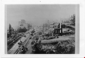
Aftermath of Great Fire of New Westminster, 1898
https://search.heritageburnaby.ca/link/museumdescription4781
- Repository
- Burnaby Village Museum
- Date
- 1898
- Collection/Fonds
- Burnaby Village Museum Photograph collection
- Description Level
- Item
- Physical Description
- 1 photograph : b&w ; 8.8 x 12.7 cm ; copy print
- Scope and Content
- Brick ruins of buildings on either side of a street with people, wagons and horses. Street runs top to bottom on left hand side of photograph.
- Repository
- Burnaby Village Museum
- Collection/Fonds
- Burnaby Village Museum Photograph collection
- Description Level
- Item
- Physical Description
- 1 photograph : b&w ; 8.8 x 12.7 cm ; copy print
- Material Details
- "Columbian files 1971" written on verso in black pen. ""FIRE" NEW WESTMINSTER SEPT. 1898." written on verso in pencil.
- Scope and Content
- Brick ruins of buildings on either side of a street with people, wagons and horses. Street runs top to bottom on left hand side of photograph.
- History
- Part of a set of photographs from the Columbian Newspaper, which operated out of New Westminster under this name starting in 1900 until its dissolution in 1988. Photographs found in the collection of the Burnaby Village are dated 1971.
- Other Title Information
- title based on content and note on verso of photograph
- Accession Code
- BV018.19.7
- Access Restriction
- No restrictions
- Reproduction Restriction
- May be restricted by third party rights
- Date
- 1898
- Media Type
- Photograph
- Scan Resolution
- 600
- Scan Date
- 24-04-2018
Images

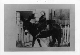
Child on donkey
https://search.heritageburnaby.ca/link/museumdescription4789
- Repository
- Burnaby Village Museum
- Date
- 1890-1900
- Collection/Fonds
- Burnaby Village Museum Photograph collection
- Description Level
- Item
- Physical Description
- 1 photograph : b&w ; 8.9 x 13.8 cm ; copy print
- Scope and Content
- Child mounted on saddled donkey facing left. Child's feet do not reach stirrups. Saddle blanket is plaid. Background includes wooden slatted buildings and picket fence.
- Repository
- Burnaby Village Museum
- Collection/Fonds
- Burnaby Village Museum Photograph collection
- Description Level
- Item
- Physical Description
- 1 photograph : b&w ; 8.9 x 13.8 cm ; copy print
- Material Details
- "Columbian files 1971." written on verso in black pen. "031" stamped on verso.
- Scope and Content
- Child mounted on saddled donkey facing left. Child's feet do not reach stirrups. Saddle blanket is plaid. Background includes wooden slatted buildings and picket fence.
- History
- Part of a set of photographs from the Columbian Newspaper, which operated out of New Westminster under this name starting in 1900 until its dissolution in 1988. Photographs found in the collection of the Burnaby Village are dated 1971.
- Other Title Information
- title based on content of photograph
- Accession Code
- BV018.19.15
- Access Restriction
- No restrictions
- Reproduction Restriction
- May be restricted by third party rights
- Date
- 1890-1900
- Media Type
- Photograph
- Scan Resolution
- 600
- Scan Date
- 24-04-2018
Images

![Douglas Road, [1897] (date of original), copied 1978 thumbnail](/media/hpo/_Data/_BVM_Images/1978/1978_0001_0001_001.jpg?width=280)
Douglas Road
https://search.heritageburnaby.ca/link/museumdescription447
- Repository
- Burnaby Village Museum
- Date
- [1897] (date of original), copied 1978
- Collection/Fonds
- Burnaby Village Museum Photograph collection
- Description Level
- Item
- Physical Description
- 1 photograph : b&w ; 20.2 x 25.2 cm print
- Scope and Content
- Photograph of Douglas Road (later renamed in part Canada Way), near Stanley Street. To the right is the Sprott family property, where a few wooden buildings are visible in the cleared area. Charles Sprott, head of the Sprott family, was an important Burnaby politician who was continuously elected t…
- Repository
- Burnaby Village Museum
- Collection/Fonds
- Burnaby Village Museum Photograph collection
- Description Level
- Item
- Physical Description
- 1 photograph : b&w ; 20.2 x 25.2 cm print
- Scope and Content
- Photograph of Douglas Road (later renamed in part Canada Way), near Stanley Street. To the right is the Sprott family property, where a few wooden buildings are visible in the cleared area. Charles Sprott, head of the Sprott family, was an important Burnaby politician who was continuously elected to serve in the municiality as councillor from 1895 to 1903 and as Reeve from 1904 to 1905.
- Subjects
- Geographic Features - Roads
- Land Clearing
- Geographic Access
- Douglas Road
- Canada Way
- Stanley Street
- Accession Code
- HV978.1.1
- Access Restriction
- No restrictions
- Reproduction Restriction
- No known restrictions
- Date
- [1897] (date of original), copied 1978
- Media Type
- Photograph
- Historic Neighbourhood
- Burnaby Lake (Historic Neighbourhood)
- Planning Study Area
- Lakeview-Mayfield Area
- Scan Resolution
- 600
- Scan Date
- 2023-07-25
- Notes
- Title based on contents of photograph
Images
![Douglas Road, [1897] (date of original), copied 1978 thumbnail](/media/hpo/_Data/_BVM_Images/1978/1978_0001_0001_001.jpg)
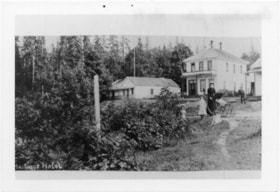
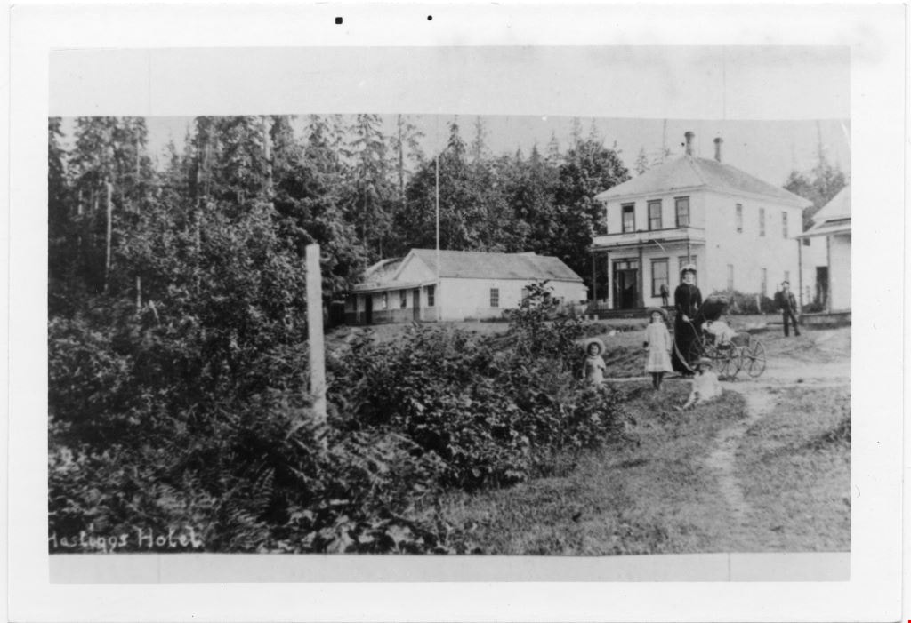
Family group in grounds of Hastings Hotel
https://search.heritageburnaby.ca/link/museumdescription4787
- Repository
- Burnaby Village Museum
- Date
- 1890-1905
- Collection/Fonds
- Burnaby Village Museum Photograph collection
- Description Level
- Item
- Physical Description
- 1 photograph : b&w ; 8.8 x 12.7 cm ; copy print
- Scope and Content
- Shrubs on left and trees in background. On right a woman with 3 children and one infant in pram. On right two and one partial white buildings in background. Two men in background. Writing on bottom left edge.
- Repository
- Burnaby Village Museum
- Collection/Fonds
- Burnaby Village Museum Photograph collection
- Description Level
- Item
- Physical Description
- 1 photograph : b&w ; 8.8 x 12.7 cm ; copy print
- Material Details
- "Columbian files Nov 71" written on verso in black pen. "Hastings Hotel" written in white on front bottom left of photograph.
- Scope and Content
- Shrubs on left and trees in background. On right a woman with 3 children and one infant in pram. On right two and one partial white buildings in background. Two men in background. Writing on bottom left edge.
- History
- Part of a set of photographs from the Columbian Newspaper, which operated out of New Westminster under this name starting in 1900 until its dissolution in 1988. Photographs found in the collection of the Burnaby Village are dated 1971.
- Other Title Information
- title based on note on and content of photograph
- Accession Code
- BV018.19.13
- Access Restriction
- No restrictions
- Reproduction Restriction
- May be restricted by third party rights
- Date
- 1890-1905
- Media Type
- Photograph
- Scan Resolution
- 600
- Scan Date
- 24-04-2018
Images
Miscellaneous papers
https://search.heritageburnaby.ca/link/archivedescription58196
- Repository
- City of Burnaby Archives
- Date
- 1870 (date of original) -1991
- Collection/Fonds
- Burnaby Historical Society fonds
- Description Level
- File
- Physical Description
- 1 file of textual records
- Scope and Content
- File consists of papers pertaining to Deer Lake's development, Burnaby's Heritage Week celebrations and potential heritage buildings. Also included in the file are Real Estate pamphlets, information on Banff Alberta as well as photocopies of early newspaper articles.
- Repository
- City of Burnaby Archives
- Date
- 1870 (date of original) -1991
- Collection/Fonds
- Burnaby Historical Society fonds
- Subseries
- Evelyn Salisbury subseries
- Physical Description
- 1 file of textual records
- Description Level
- File
- Record No.
- MSS061-036
- Access Restriction
- No restrictions
- Accession Number
- BHS1991-24
- Scope and Content
- File consists of papers pertaining to Deer Lake's development, Burnaby's Heritage Week celebrations and potential heritage buildings. Also included in the file are Real Estate pamphlets, information on Banff Alberta as well as photocopies of early newspaper articles.
- Media Type
- Textual Record
- Notes
- Title based on contents of file
Rhymes of the kings and queens of England
https://search.heritageburnaby.ca/link/museumlibrary2904
- Repository
- Burnaby Village Museum
- Author
- Leslie, Mary, 1842-1920
- Publication Date
- 1896
- Call Number
- 811.4 LES
- Repository
- Burnaby Village Museum
- Collection
- Special Collection
- Material Type
- Book
- Accession Code
- HV973.160.2
- Call Number
- 811.4 LES
- Author
- Leslie, Mary, 1842-1920
- Place of Publication
- Toronto
- Publisher
- William Briggs, Wesley Buildings
- Publication Date
- 1896
- Physical Description
- 177 p. : ill., ports. ; 18 cm.
- Inscription
- Front endpaper: "1909 D. Chartere" [written in pencil] "NOT IN LIBRARY SERVICE" [written in pencil] Piece of thin tissue paper between frontispiece and title page: An attempt at tracing the frontispiece portrait of Queen Victoria - part of face and right arm. Title page and front endpapers have the following stamped in purple ink: "Gilmore Avenue School LIBRARY Book Number ________ Catalogue Page ______" "R 134" is written in blue ink in the "Book Number" blank, on the endpaper stamps.
- Library Subject (LOC)
- Poetry
- Queens--Great Britain
- Great Britain--Kings and rulers
- Notes
- "Being an account of the rulers of England from the Normal conquest to the reign of Victoria." -- t.p.
![Survey and Subdivision plans in New Westminster District Group 1 – Burnaby
, [1861]-[1910] thumbnail](/media/hpo/_Data/_BVM_Cartographic_Material/1977/1977_0093_0019a_001.jpg?width=280)
Survey and Subdivision plans in New Westminster District Group 1 – Burnaby
https://search.heritageburnaby.ca/link/museumdescription6988
- Repository
- Burnaby Village Museum
- Date
- [1861]-[1910]
- Collection/Fonds
- Burnaby Village Museum Map collection
- Description Level
- File
- Physical Description
- 14 plans : 3 plans : black ink on paper hand col. + 7 plans : black ink on paper + 4 plans : graphite on paper mounted on 2 sides of cardboard 76 x 102 cm
- Scope and Content
- Item consists of a large board of four New Westminster District Gp 1 - subdivision plans mounted on one side and ten New Westminster District Gp 1 - subdivision plans mounted on the other side. Side A: 1. "Plan /of / Lots 166A, 166 and 167 /, Gr.1, N.W.D. / Showing Misconstructed Roads in Gree…
- Repository
- Burnaby Village Museum
- Collection/Fonds
- Burnaby Village Museum Map collection
- Description Level
- File
- Physical Description
- 14 plans : 3 plans : black ink on paper hand col. + 7 plans : black ink on paper + 4 plans : graphite on paper mounted on 2 sides of cardboard 76 x 102 cm
- Material Details
- Scales [between 1:2376 and 1:7920]
- Index number on edge of board reads: "19"
- Scope and Content
- Item consists of a large board of four New Westminster District Gp 1 - subdivision plans mounted on one side and ten New Westminster District Gp 1 - subdivision plans mounted on the other side. Side A: 1. "Plan /of / Lots 166A, 166 and 167 /, Gr.1, N.W.D. / Showing Misconstructed Roads in Green / 5 chs = 1 in.". (plan is drawn in black ink and hand coloured in red, green and orange ink). A section in the centre of the plan is coloured in red ink and identified as "C.S. Richmond" running from the North Arm of Fraser River to Wiggins Road and divided by "New Wiggins Rd. (as gazetted)" (coloured in orange ink) and two"Constructed Road(s)" (coloured in green ink). Plan is initialed by: "RB" [sic] (in blue pencil crayon) 2. Plan of / Subdivision of / Lot 166 / Group One / New Westminster District / Scale 4 chs = 1 in. / Map No 524". Plan is drawn in graphite and signed by "Surrig [sic] Welhams [sic] / P.L.S." Plan is initialed by: "RB" [sic] (in blue pencil crayon) 3. Plan of "Survey / of Highway / For / Burnaby Council / in / Lots 13 _14 / Group One / Scale 4 chs = 1 in." Signed by "Albert J. Hill, P.L.S." Caribou Street and Caribou Road run through the centre of the plan. Plan is stamped: "Albert J. Hill, Civil Engineer / and / Provincial Land Surveyor, / New Westminster, / B.C.". Plan is initialed by: "RB" [sic] (in blue pencil crayon) 4. A Plan of Lots 166A, 166 and 167, Group One, New Westminster District (drawn in graphite). A section in the centre of the plan is identified as "C.S. Richmond" running from the North Arm of Fraser River and divided by "New Wiggins Rd. (as gazetted)" and two "Constructed Road(s)". Plan is initialed by: "RB" [sic] (in blue pencil crayon) Side B: 1. Small plan drawn in black ink (no title) identifying lots north of the "North Arm" of the Fraser River. Lots identified include: Lot 99, Lot 98, Lot 157, Lot 158, Lot 163, Lot 162, Lot 159, Lot 163, Lot 162, Lot 165, Lot 166A, Lot 155B, Lot 155A and Lot 159. "Scale 40 chains to one inch" . Plan is initialed by: "RB" [sic] (in blue pencil crayon) (Geographic location: Burnaby) 2. Small plan drawn in black ink (no title) identifying lots north of the North Arm of the Fraser River as "Lots 155, 155A, 155B, 155C, 162, 163, 164, 165, 166A and 167". Plan is initialed by: "RB" [sic] (in blue pencil crayon) (Geographic location: Burnaby) 3. Small plan drawn in black ink (no title) which identifies "Lot 151 / Reserve/ for / Race Course"; "Reserve / 64 A / L. 152 G.1"; and other Lots: 32, 33, 34, 35, 36, 38, 39. The plan is signed "Surveyor G.Turn [sic] July / 61 / from Vol 40 R.L. notes [sic]" Plan is stamped: "Albert J. Hill, Civil Engineer / and / Provincial Land Surveyor, / New Westminster, / B.C." Plan is initialed by: "RB" [sic] (in blue pencil crayon) (Geographic location: Burnaby) 4. Small plan drawn in black in with faded red colouring on centre lot identified as "Lot 34" running north from "Vancouver Road" . Plan is stamped: "Albert J. Hill, Civil Engineer / and / Provincial Land Surveyor, / New Westminster, / B.C." Plan is initialed by: "RB" [sic] (in blue pencil crayon) (Geographic location: Burnaby) 5. Plan drawn in graphite and identified as "Lot 98, Gr.1," along with the intials "RB" [sic] (both are handwritten in blue crayon pencil on top of plan) The B.C.E.Railway is identified running through the plan along with Jubilee Road and Royal Oak Road. The plan is signed with the name "Wm. Murray" and the Plan is stamped: "Albert J. Hill, Civil Engineer / and / Provincial Land Surveyor, / New Westminster, / B.C.". (Geographic location: Burnaby) 6. Plan drawn in graphite identified as "Port Lot 13, Gr.1" along with the intials "RB" [sic] (both are handwritten in blue crayon pencil on top of plan) Plan is stamped: "Albert J. Hill, Civil Engineer / and / Provincial Land Surveyor, / New Westminster, / B.C.". (Geographic location: Burnaby) 7.Plan drawn in black ink and identified as "Lot 98 G.1" along with the intials "RB" [sic] (both are handwritten in blue crayon pencil on top of plan). A "Road Reservation" is identified running north between "Electric Tramway" and connecting with "Royal Oak Road". Plan is stamped: "Albert J. Hill, Civil Engineer / and / Provincial Land Surveyor, / New Westminster, / B.C." (Geographic location: Burnaby) 8. Plan drawn in black ink and divided into two sections, the upper plan is identified as "Portion / Lots 100 / area / 101, Gr.1" and the lower plan is identified as "Portion L. 3 G. 1" along with the intials "RB" [sic] (these identifiers are handwritten in blue crayon pencil on top of the plan). Portions of Lot 100 and Lot 101 are each divided into 6 sections and the Portion of Lot 3 plan is divided into 24 sections. The plan includes a note in black ink that reads: " Received from Wm Fromme [sic] / from Wm. Trapp / Nov. 28, 1895 / A. J. T...[sic]". (Geographic location: Burnaby) 9. Plan drawn in black ink (no title) identifying soil, buildings and geographic features in southern Burnaby. The plan is bordered by "New Westminster City" (Tenth Avenue and DL 172) to the south east and DL 173 to the south, DL 158 to the west and the B.C.E. Tramway to the north. Plan includes District Lots: 155A, 158, 159, 171, 160, 53 and 95 and identifies soil, marshland and ravines throughout. Plan identifies the following features: a "Team Road" running through Lots 158 and 159 along with "Fair Orchard Soil / Even Surface Throughout / No Ravines", "Gravel and Shingle" (bottom of Lot 158), "North Arm Road" crossing "Byrne Road" and connecting with "Power House Road" which runs north to connect with "Highland Park Station" and the B.C.E. Tramway, "Power Ho" in the northeast corner of DL 160, a "Brook" connected with a "Deep Ravine" running between DL 53, DL 95 and DL 160 along with "Good Soil" and "Fair Orchard Soil" identified nearby in DL 95. Scale is identified as "10 chs = 1 in." Plan is stamped: "Albert J. Hill, Civil Engineer / and / Provincial Land Surveyor, / New Westminster, / B.C." Plan is initialed by: "RB" [sic] (in blue pencil crayon) (Geographic location: Burnaby) 10. Plan drawn in black ink (no title) with Burnaby Lake and Deer Lake at the centre. The plan is bordered by the following District Lots identified as: 117, 118 and 68 to the west, Lots 80, 79 and 85 to the southwest, Lots 11, 13, and 1 (City of New Westminster) to the south east, the North Road boundary to the east and Lots 8, 56, 57, 59, and 136 to the North. The lower right hand corner of the plan has a small inset which reads: "Burnaby Lake" and "Page 19 R.B. Notes". Plan is initialed by: "RB" [sic] (in blue pencil crayon) (Geographic location: Burnaby)
- Creator
- Hill, Albert James
- Accession Code
- HV977.93.19
- Access Restriction
- No restrictions
- Reproduction Restriction
- No known restrictions
- Date
- [1861]-[1910]
- Media Type
- Cartographic Material
- Scan Resolution
- 300
- Scale
- 72
- Notes
- Title based on contents of file
- Scale is measured in chains. (One chain equals 792 inches)
- The term "Lot" can also refer to a "District Lot”
- Some plans are stamped: "Albert J. Hill, Civil Engineer / and / Provincial Land Surveyor, / New Westminster, / B.C." and intialed: "RB" [sic]
Images
![Survey and Subdivision plans in New Westminster District Group 1 – Burnaby
, [1861]-[1910] thumbnail](/media/hpo/_Data/_BVM_Cartographic_Material/1977/1977_0093_0019a_001.jpg)
