Narrow Results By
Person / Organization
- Alpha Secondary School 1
- Beamish, Agnes 1
- Burnaby Central Secondary School 1
- Cascade Heights Elementary School 1
- Cliff's Can Factory 1
- Derrick, Brenda 1
- Derrick, Ethel Beamish 1
- Gilmore Avenue School 1
- Gooden, Tom 1
- James Brookes Woodworking Limited 1
- Moscrop Secondary School 1
- Schou Street School 1
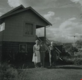
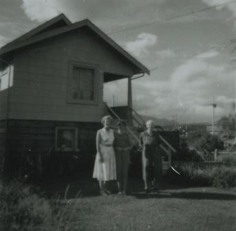
Ethel Derrick, Brenda Derrick and Agnes Beamish
https://search.heritageburnaby.ca/link/archivedescription37679
- Repository
- City of Burnaby Archives
- Date
- 1958 (date of original), copied 1991
- Collection/Fonds
- Burnaby Historical Society fonds
- Description Level
- Item
- Physical Description
- 1 photograph : b&w ; 3.7 x 3.7 cm print on contact sheet 20.2 x 25.3 cm
- Scope and Content
- Photograph of three generations; Ethel Beamish Derrick, her daughter Brenda Derrick and her mother Agnes Beamish, standing in front of the Beamish family home at 277 17th Avenue (later renumbered 8059 17th Avenue).
- Repository
- City of Burnaby Archives
- Date
- 1958 (date of original), copied 1991
- Collection/Fonds
- Burnaby Historical Society fonds
- Subseries
- Burnaby Image Bank subseries
- Physical Description
- 1 photograph : b&w ; 3.7 x 3.7 cm print on contact sheet 20.2 x 25.3 cm
- Description Level
- Item
- Record No.
- 370-267
- Access Restriction
- No restrictions
- Reproduction Restriction
- No restrictions
- Accession Number
- BHS1999-03
- Scope and Content
- Photograph of three generations; Ethel Beamish Derrick, her daughter Brenda Derrick and her mother Agnes Beamish, standing in front of the Beamish family home at 277 17th Avenue (later renumbered 8059 17th Avenue).
- Subjects
- Buildings - Residential - Houses
- Media Type
- Photograph
- Notes
- Title based on contents of photograph
- 1 b&w copy negative accompanying
- Geographic Access
- 17th Avenue
- Street Address
- 8059 17th Avenue
- Historic Neighbourhood
- East Burnaby (Historic Neighbourhood)
- Planning Study Area
- Second Street Area
Images
![Inter-City Golf Driving Range, [195-] (date of original); 2013 (date of duplication) thumbnail](/media/hpo/_Data/_Archives_Images/_Unrestricted/550/557-021.jpg?width=280)
Inter-City Golf Driving Range
https://search.heritageburnaby.ca/link/archivedescription78770
- Repository
- City of Burnaby Archives
- Date
- [195-] (date of original); 2013 (date of duplication)
- Collection/Fonds
- Walker family fonds
- Description Level
- Item
- Physical Description
- 1 photograph (jpeg) : b&w ; 96 dpi
- Scope and Content
- Photograph of the Inter-City Golf Driving Range in Burnaby.
- Repository
- City of Burnaby Archives
- Date
- [195-] (date of original); 2013 (date of duplication)
- Collection/Fonds
- Walker family fonds
- Physical Description
- 1 photograph (jpeg) : b&w ; 96 dpi
- Description Level
- Item
- Record No.
- 557-021
- Access Restriction
- No restrictions
- Reproduction Restriction
- No restrictions
- Accession Number
- 2013-15
- Scope and Content
- Photograph of the Inter-City Golf Driving Range in Burnaby.
- Media Type
- Photograph
- Notes
- Title based on contents of photograph
- Geographic Access
- 10th Avenue
- Historic Neighbourhood
- Edmonds (Historic Neighbourhood)
- Planning Study Area
- Edmonds Area
Images
![Inter-City Golf Driving Range, [195-] (date of original); 2013 (date of duplication) thumbnail](/media/hpo/_Data/_Archives_Images/_Unrestricted/550/557-021.jpg)
![Inter-City Golf Driving Range clubhouse, [1954] (date of original); 2013 (date of duplication) thumbnail](/media/hpo/_Data/_Archives_Images/_Unrestricted/550/557-024.jpg?width=280)
Inter-City Golf Driving Range clubhouse
https://search.heritageburnaby.ca/link/archivedescription78773
- Repository
- City of Burnaby Archives
- Date
- [1954] (date of original); 2013 (date of duplication)
- Collection/Fonds
- Walker family fonds
- Description Level
- Item
- Physical Description
- 1 photograph (jpeg) : b&w ; 300 dpi
- Scope and Content
- Photograph of a tractor attempting to move the Inter-City Golf Driving Range's clubhouse.
- Repository
- City of Burnaby Archives
- Date
- [1954] (date of original); 2013 (date of duplication)
- Collection/Fonds
- Walker family fonds
- Physical Description
- 1 photograph (jpeg) : b&w ; 300 dpi
- Description Level
- Item
- Record No.
- 557-024
- Access Restriction
- No restrictions
- Reproduction Restriction
- No known restrictions
- Accession Number
- 2013-15
- Scope and Content
- Photograph of a tractor attempting to move the Inter-City Golf Driving Range's clubhouse.
- Media Type
- Photograph
- Notes
- Title based on contents of photograph
- Geographic Access
- 10th Avenue
- Historic Neighbourhood
- Edmonds (Historic Neighbourhood)
- Planning Study Area
- Edmonds Area
Images
![Inter-City Golf Driving Range clubhouse, [1954] (date of original); 2013 (date of duplication) thumbnail](/media/hpo/_Data/_Archives_Images/_Unrestricted/550/557-024.jpg)
![Inter-City Golf Driving Range clubhouse, [1954] (date of original); 2013 (date of duplication) thumbnail](/media/hpo/_Data/_Archives_Images/_Unrestricted/550/557-025.jpg?width=280)
Inter-City Golf Driving Range clubhouse
https://search.heritageburnaby.ca/link/archivedescription78774
- Repository
- City of Burnaby Archives
- Date
- [1954] (date of original); 2013 (date of duplication)
- Collection/Fonds
- Walker family fonds
- Description Level
- Item
- Physical Description
- 1 photograph (jpeg) : b&w ; 300 dpi
- Scope and Content
- Photograph of a tractor attempting to move the Inter-City Golf Driving Range's clubhouse.
- Repository
- City of Burnaby Archives
- Date
- [1954] (date of original); 2013 (date of duplication)
- Collection/Fonds
- Walker family fonds
- Physical Description
- 1 photograph (jpeg) : b&w ; 300 dpi
- Description Level
- Item
- Record No.
- 557-025
- Access Restriction
- No restrictions
- Reproduction Restriction
- No known restrictions
- Accession Number
- 2013-15
- Scope and Content
- Photograph of a tractor attempting to move the Inter-City Golf Driving Range's clubhouse.
- Media Type
- Photograph
- Notes
- Title based on contents of photograph
- Geographic Access
- 10th Avenue
- Historic Neighbourhood
- Edmonds (Historic Neighbourhood)
- Planning Study Area
- Edmonds Area
Images
![Inter-City Golf Driving Range clubhouse, [1954] (date of original); 2013 (date of duplication) thumbnail](/media/hpo/_Data/_Archives_Images/_Unrestricted/550/557-025.jpg)
![Inter-City Golf Range, [1952] (date of original); 2013 (date of annotation) thumbnail](/media/hpo/_Data/_Archives_Images/_Unrestricted/550/557-035.jpg?width=280)
Inter-City Golf Range
https://search.heritageburnaby.ca/link/archivedescription78785
- Repository
- City of Burnaby Archives
- Date
- [1952] (date of original); 2013 (date of annotation)
- Collection/Fonds
- Walker family fonds
- Description Level
- Item
- Physical Description
- 1 photograph (jpeg) : b&w ; 96 dpi
- Scope and Content
- Photograph of members of the Walker family teeing off at the Inter-City Golf Range annotated with date, title and identification key.
- Repository
- City of Burnaby Archives
- Date
- [1952] (date of original); 2013 (date of annotation)
- Collection/Fonds
- Walker family fonds
- Physical Description
- 1 photograph (jpeg) : b&w ; 96 dpi
- Description Level
- Item
- Record No.
- 557-035
- Access Restriction
- No restrictions
- Reproduction Restriction
- No known restrictions
- Accession Number
- 2013-15
- Scope and Content
- Photograph of members of the Walker family teeing off at the Inter-City Golf Range annotated with date, title and identification key.
- Media Type
- Photograph
- Notes
- Transcribed title
- Geographic Access
- 10th Avenue
- Historic Neighbourhood
- Edmonds (Historic Neighbourhood)
- Planning Study Area
- Edmonds Area
Images
![Inter-City Golf Range, [1952] (date of original); 2013 (date of annotation) thumbnail](/media/hpo/_Data/_Archives_Images/_Unrestricted/550/557-035.jpg)
Interview with Janet White May 10, 2005 - Track 1
https://search.heritageburnaby.ca/link/museumdescription4370
- Repository
- Burnaby Village Museum
- Date
- [195-] (interview content), interviewed May 10, 2005
- Collection/Fonds
- Burnaby Village Museum fonds
- Description Level
- Item
- Physical Description
- 1 sound recording (mp3) (0:03:12 min)
- Scope and Content
- Track 1: This portion of the recording pertains to Janet White’s school years and the activities and sports she participated in, formally and informally. She lived near 6th and Edmonds St., and then in the Cascades area, by Nithsdale St., and attended Schou Elementary. She attended many schools as …
- Repository
- Burnaby Village Museum
- Collection/Fonds
- Burnaby Village Museum fonds
- Series
- Museum Oral Histories series
- Subseries
- Growing Up in Burnaby subseries
- Description Level
- Item
- Physical Description
- 1 sound recording (mp3) (0:03:12 min)
- Material Details
- Interviewer: Tom Gooden Interviewee: Janet White Date of interview: May 10, 2005 Total Number of Tracks: 8 Total length of all Tracks: 0:31:34
- Scope and Content
- Track 1: This portion of the recording pertains to Janet White’s school years and the activities and sports she participated in, formally and informally. She lived near 6th and Edmonds St., and then in the Cascades area, by Nithsdale St., and attended Schou Elementary. She attended many schools as soon as they were built, attending Gilmore Avenue, then Cascade Heights, Alpha Junior High, Moscrop Secondary, and finally Burnaby Central Secondary. Play was unstructured, with the Cascades bush and the tunnel parallel to and going under Smith Avenue being favourite places to play.
- History
- Recording of an interview with Janet White recording by Tom Gooden on May 10 2005. This recording was completed for an exhibit, Growing Up in Burnaby, for the Burnaby Village Museum. Major themes discussed are growing up in Burnaby in the 1950s.
- Creator
- Burnaby Village Museum
- Names
- Gooden, Tom
- White, Janet
- Schou Street School
- Gilmore Avenue School
- Cascade Heights Elementary School
- Alpha Secondary School
- Moscrop Secondary School
- Burnaby Central Secondary School
- Geographic Access
- 6th Street
- Edmonds Street
- Accession Code
- BV017.45.1
- Access Restriction
- No restrictions
- Reproduction Restriction
- May be restricted by third party rights
- Date
- [195-] (interview content), interviewed May 10, 2005
- Media Type
- Sound Recording
- Planning Study Area
- Cascade-Schou Area
Audio Tracks
Interview with Janet White May 10, 2005 - Track 1, [195-] (interview content), interviewed May 10, 2005
Interview with Janet White May 10, 2005 - Track 1, [195-] (interview content), interviewed May 10, 2005
https://search.heritageburnaby.ca/media/hpo/_Data/_BVM_Sound_Recordings/Oral_Histories/2017_0045_0001_001.mp3
Woodworking Plant
https://search.heritageburnaby.ca/link/archivedescription35247
- Repository
- City of Burnaby Archives
- Date
- 1954 (date of original), copied 1986
- Collection/Fonds
- Burnaby Historical Society fonds
- Description Level
- Item
- Physical Description
- 1 photograph : b&w ; 12.7 x 17.8 cm print
- Scope and Content
- Photograph of James Brookes Woodworking Plant, located at 7730 6th Street, taken from 6th Avenue after a heavy snowfall. The plant was built originally as Cliff's Can Factory, and also served as Western Canadian Can Factory.
- Repository
- City of Burnaby Archives
- Date
- 1954 (date of original), copied 1986
- Collection/Fonds
- Burnaby Historical Society fonds
- Subseries
- Pioneer Tales subseries
- Physical Description
- 1 photograph : b&w ; 12.7 x 17.8 cm print
- Description Level
- Item
- Record No.
- 204-104
- Access Restriction
- No restrictions
- Reproduction Restriction
- Reproduce for fair dealing purposes only
- Accession Number
- BHS1988-03
- Scope and Content
- Photograph of James Brookes Woodworking Plant, located at 7730 6th Street, taken from 6th Avenue after a heavy snowfall. The plant was built originally as Cliff's Can Factory, and also served as Western Canadian Can Factory.
- Media Type
- Photograph
- Notes
- Title based on contents of photograph
- Geographic Access
- 6th Street
- Street Address
- 7730 6th Street
- Historic Neighbourhood
- East Burnaby (Historic Neighbourhood)
- Planning Study Area
- Second Street Area
Images
